Items Similar to Nova Persiae, Armeniae, Natoliae et Ara.. - Etching by Frederick de Wit - 1680ca
Want more images or videos?
Request additional images or videos from the seller
1 of 5
Frederick de WitNova Persiae, Armeniae, Natoliae et Ara.. - Etching by Frederick de Wit - 1680ca 1680 ca
1680 ca
$1,420.18
£1,079.88
€1,200
CA$1,992.67
A$2,177.40
CHF 1,128.84
MX$26,012.17
NOK 14,365.15
SEK 13,449.19
DKK 9,139.86
About the Item
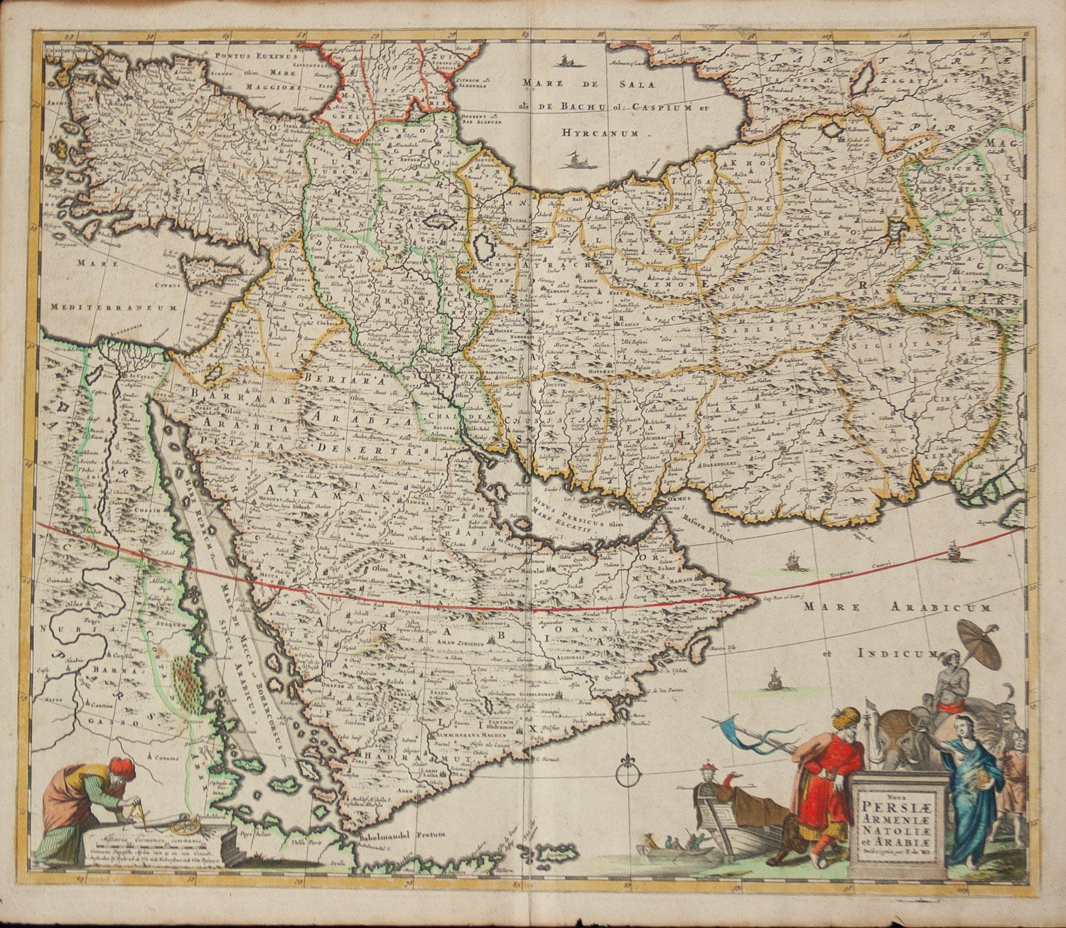
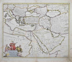
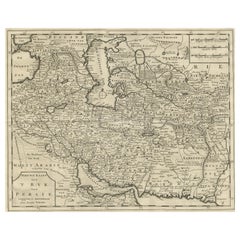
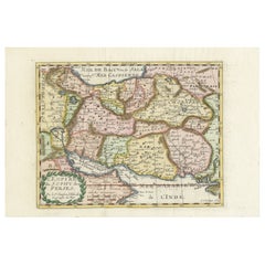
This double-page etching with contemporary coloring, entitled Nova Persiae, Armeniae, Natoliae et Arabiae, was realized by the cartographer Frederick de Wit for the famous Atlas published in Amsterdam in ca. 1680.
The state of preservation is fair: central fold reinforced in antiquity on the reverse, cropped margins, slight defects, stains and browning of the paper.
Folio, measures ca. cm 51,5x59,8
Inscription on the reverse "Foglio 18 / Persia Armenia Natolia Arabia "
Frederick de Wit was a cartographer and map-seller who was best known for his atlases and his Dutch town maps. His maps were known for their accuracy and detail, and contributed significantly to the documentation and understanding of the lands explored and discovered in the 17th century. His work had a considerable influence on the diffusion of geographical and cartographic knowledge of the time.
- Creator:Frederick de Wit (1630 - 1706, Dutch)
- Creation Year:1680 ca
- Dimensions:Height: 20.28 in (51.5 cm)Width: 23.55 in (59.8 cm)Depth: 0.04 in (1 mm)
- Medium:
- Movement & Style:
- Period:1680-1689
- Framing:Framing Options Available
- Condition:Insurance may be requested by customers as additional service, contact us for more information.
- Gallery Location:Roma, IT
- Reference Number:Seller: T-1549081stDibs: LU650316393492

Frederick de Wit
Frederick De Wit (1629-1706) was an engraver, cartographer and map dealer who ran a prominent and productive printing business in Amsterdam, founded in 1654 and initially called The Three Crabs and later The White Chart. He published his first atlas in 1662. In 1695 he purchased a large collection of the plates of the prestigious Blaeu publishing business. After his death in 1706, his wife Maria continued in the business for four years before selling it at the auction. A majority of the plates were purchased by Pieter Mortier. His thriving and growing business eventually became Covens & Mortier, one of the largest and most successful cartography and printing businesses of the eighteenth century.
About the Seller
4.9
Platinum Seller
Premium sellers with a 4.7+ rating and 24-hour response times
1stDibs seller since 2017
7,813 sales on 1stDibs
Typical response time: 1 hour
- ShippingRetrieving quote...Shipping from: Grasse, France
- Return Policy
More From This Seller
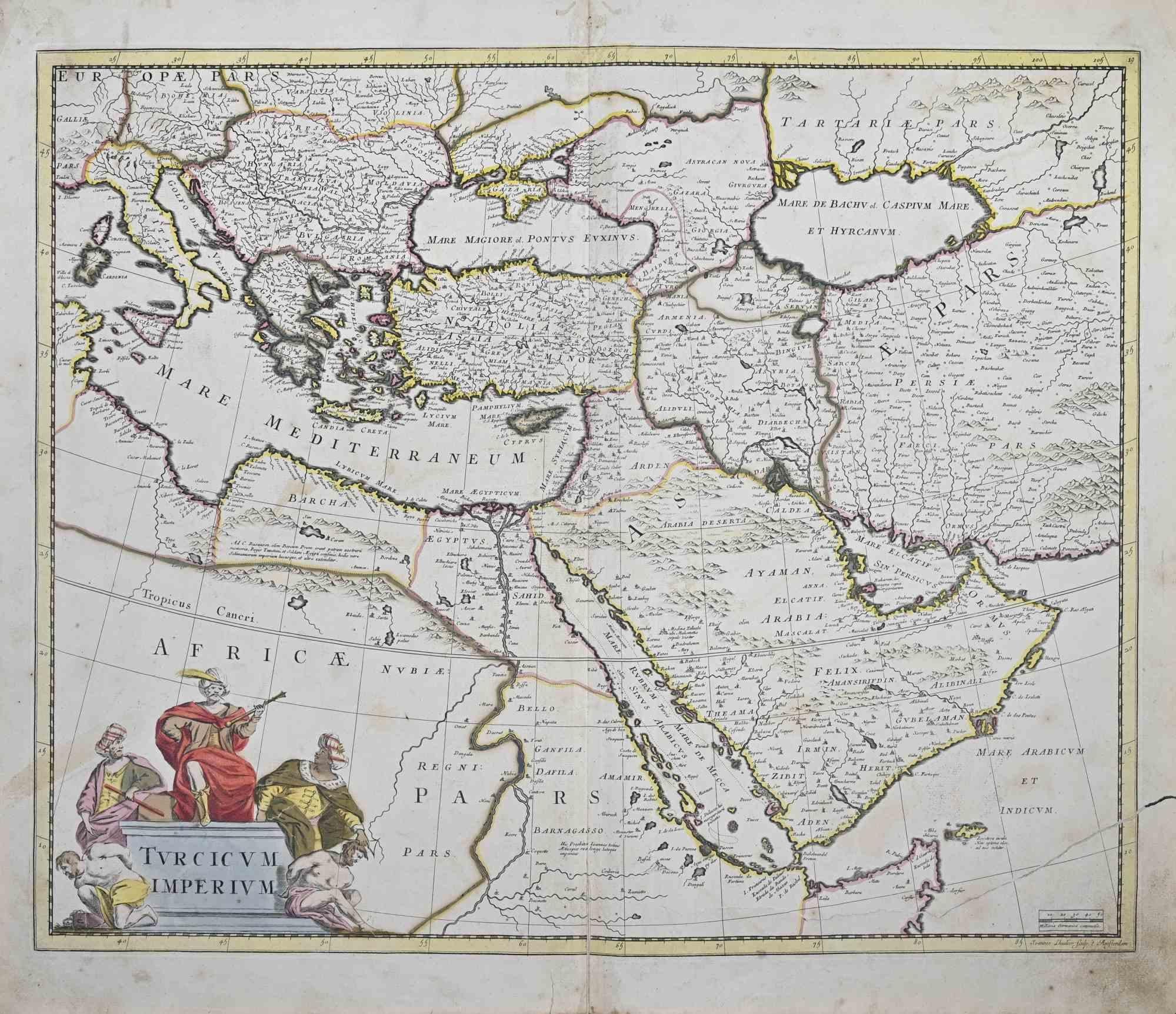
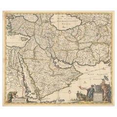
View AllTurcicum Imperium - Etching by Frederick de Wit - 1680ca
By Frederick de Wit
Located in Roma, IT
This double-page etching with contemporary coloring, entitled Turcicum Imperium, was realized by the cartographer Frederick de Wit for the famous Atlas published in Amsterdam in ca. ...
Category
1680s Modern Figurative Prints
Materials
Etching
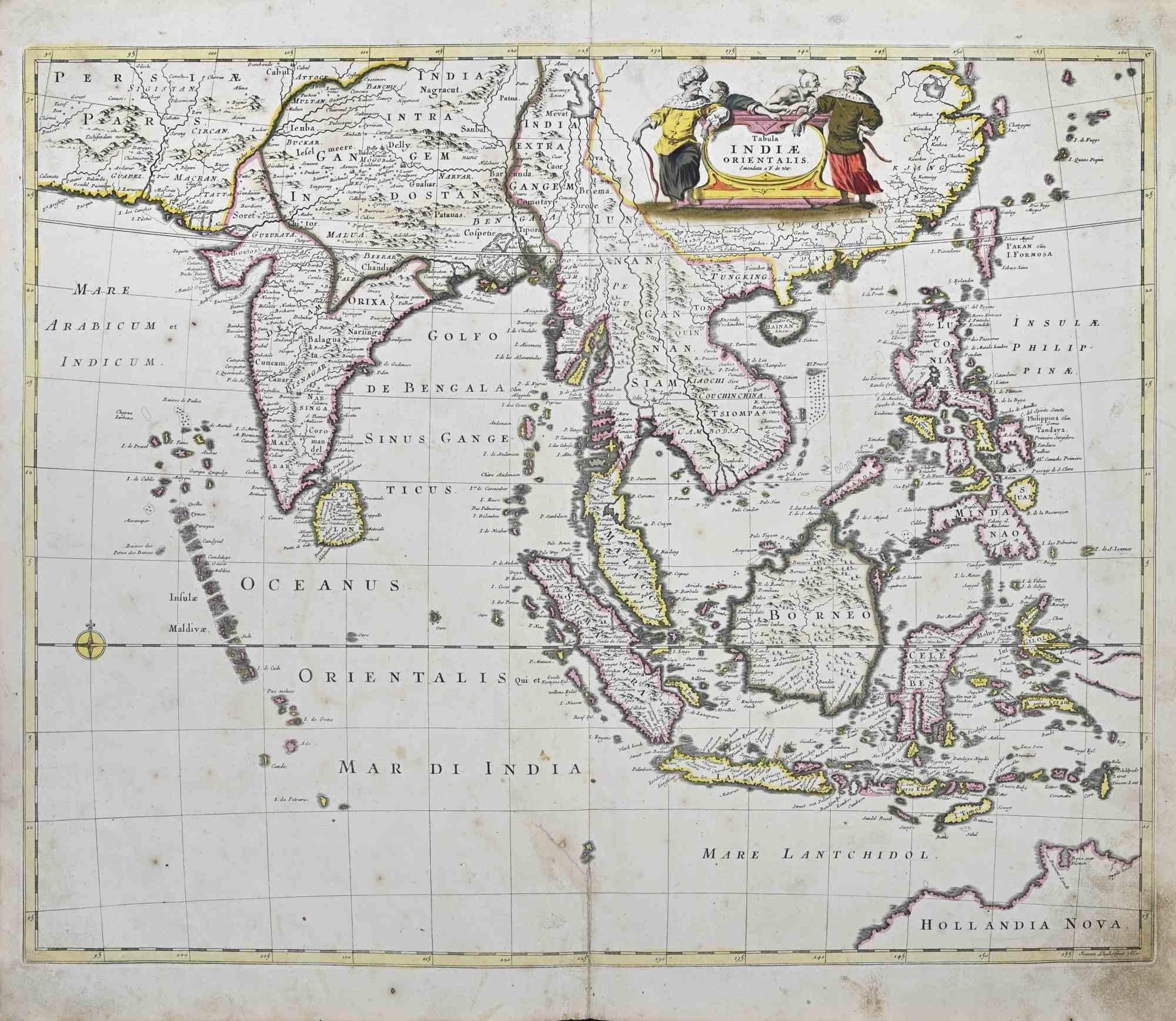
Tabula Indiae Orientalis - Etching by Frederick de Wit - 1680ca
By Frederick de Wit
Located in Roma, IT
This double-page etching with contemporary coloring, entitled Tabula Indiae orientalis, was realized by the cartographer Frederick de Wit for the famous Atlas published in Amsterdam ...
Category
1680s Modern Figurative Prints
Materials
Etching

$1,325 Sale Price
20% Off
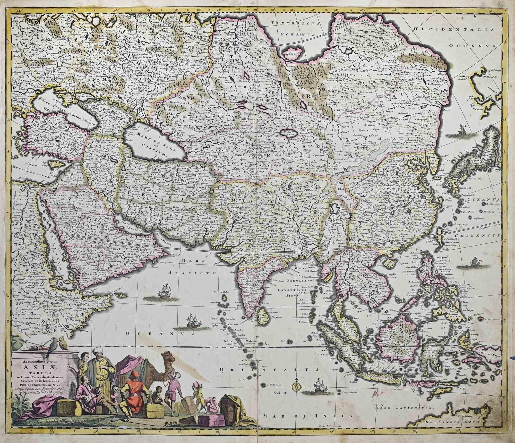
Accuratissima Totius Asiae Tabula - Etching by Frederick de Wit - 1680 ca
By Frederick de Wit
Located in Roma, IT
This double-page etching with contemporary coloring, entitled Accuratissima totius Asiae Tabula, was realized by the cartographer Frederick de Wit for the famous Atlas published in A...
Category
1680s Modern Figurative Prints
Materials
Etching

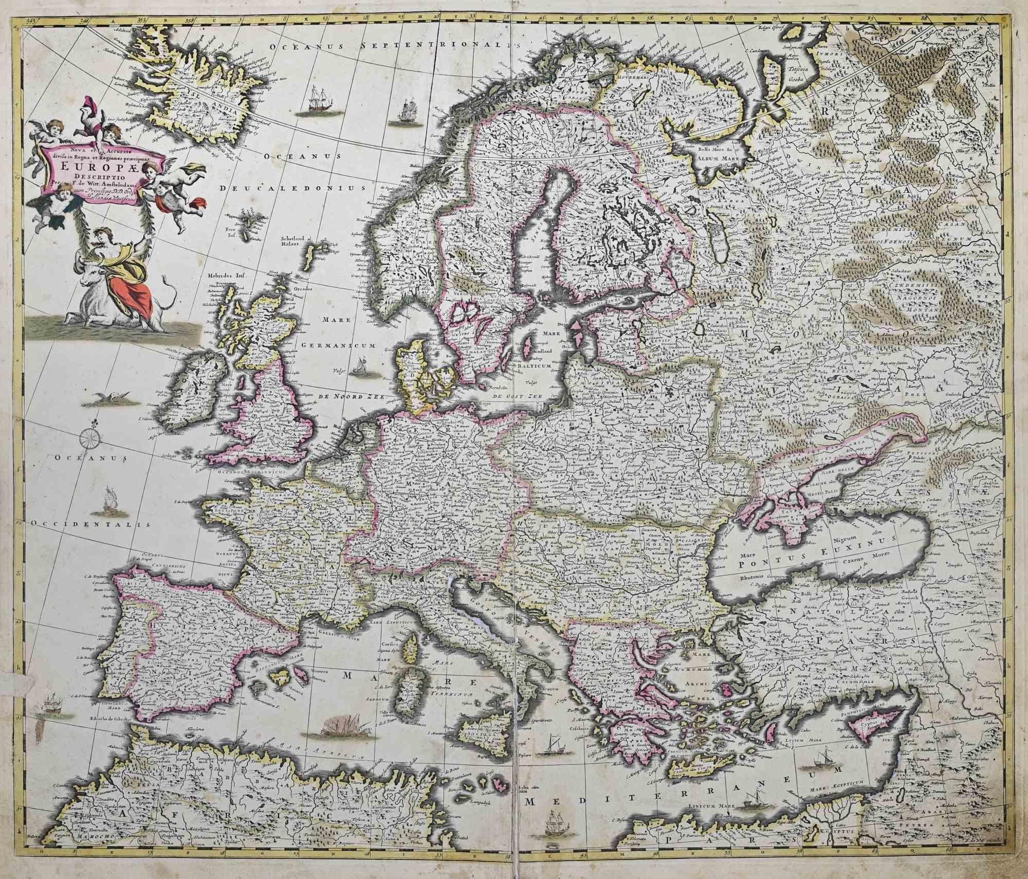
Nova et Accurata Totius Europae Descriptio- Etching by Frederick de Wit - 1680ca
By Frederick de Wit
Located in Roma, IT
This double-page etching with contemporary coloring, entitled Nova et Accurata Totius Europae Descriptio, was realized by the cartographer Frederick de Wit for the famous Atlas publi...
Category
1680s Modern Figurative Prints
Materials
Etching
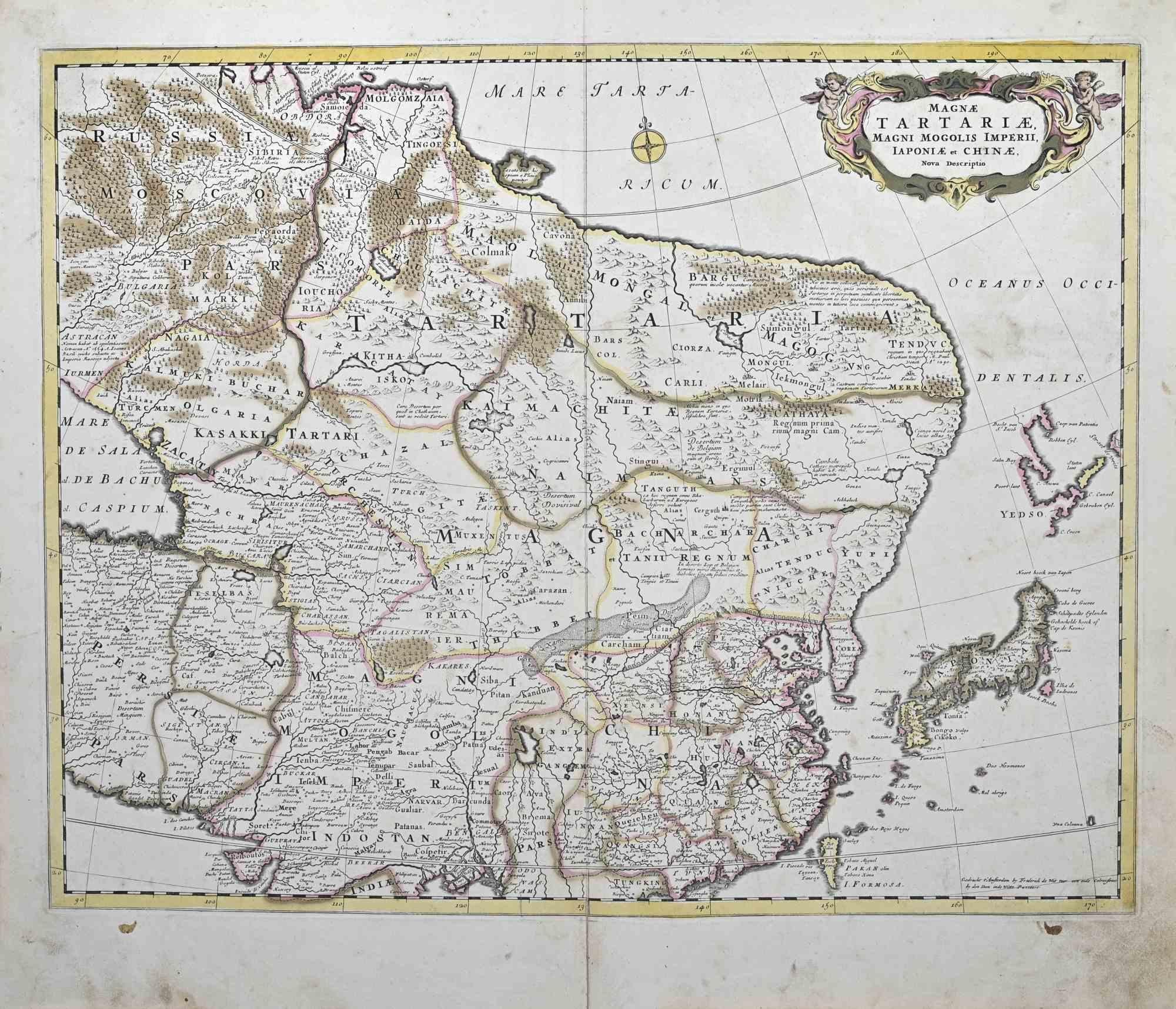
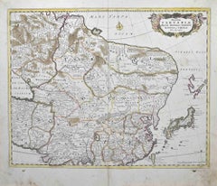
Magnae Tartariae - Etching by Frederick de Wit - 1680ca
By Frederick de Wit
Located in Roma, IT
This double-page etching with contemporary coloring, entitled Magnae Tartariae, was realized by the cartographer Frederick de Wit for the famous Atlas published in Amsterdam in ca. 1...
Category
1680s Modern Figurative Prints
Materials
Etching
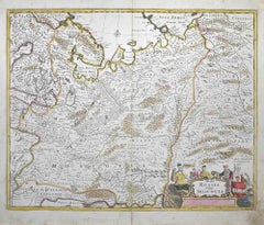
Tabula Russia Vulgo Moscovia - Etching by Frederick de Wit - 1680ca
By Frederick de Wit
Located in Roma, IT
This double-page etching with contemporary coloring, entitled Tabula Russia vulgo Moscovia, was realized by the cartographer Frederick de Wit for the famous Atlas published in Amster...
Category
1680s Modern Figurative Prints
Materials
Etching
You May Also Like
Persiae, Armeniae, Natoliae et Arabiae Descriptio per Frederick deWit 1666 map
Located in Paonia, CO
Map of Persiae, Armeniae, Natoliae et Arabiae Descriptio per F de Wit 1688 engraving from: Atlas Contractus Orbis Terrarum Praecipuas ac Novissimas Complectens Tabulas. Amsterdam, N. Visscher, 1656-77. (Koeman III, Vis5-8) This highly decorative map of the Middle East is by the Dutch engraver, publisher, and map seller...
Category
1660s Realist Landscape Prints
Materials
Engraving

Map of Persia, the Caspian & India – Isaak Tirion, c.1730
Located in Langweer, NL
Map of Persia and Surrounding Regions – “Nieuwe Kaart van 't Ryck van Persie” by Isaak Tirion, Amsterdam, c. 1730
This finely detailed copperplate map titled “Nieuwe Kaart van 't Ry...
Category
Antique Mid-18th Century Dutch Maps
Materials
Paper
Finely Engraved Historical Map of Middle East and Asia, c.1745
Located in Langweer, NL
Description: Antique map titled'Theatrum Historicum pars Orientalis.'
Finely engraved historical map with a profusion of details. It shows the Middle East and Asia. Decorative ti...
Category
Antique 1740s Maps
Materials
Paper

Circa 1691 Frederick de Wit Map: Middle East with Arabia, Persia & More
Located in Langweer, NL
Circa 1691 Frederick de Wit Map: Middle East with Arabia, Persia & More
This exquisite hand-colored map, circa 1691, by Frederick de Wit, illustrates the Middle East, spanning from Turkey and Egypt to Afghanistan, with a detailed representation of the Arabian Peninsula.
The map's detailing in Arabia is based on Nicolas Sanson's influential 1654 map, which was one of the most accurate and detailed depictions of the region up to the mid-seventeenth century.
The decorative title cartouche is richly adorned with images of exotic figures, animals, and a merchant ship, symbolizing the region's historical trade importance. Additionally, a mapmaker is shown working with traditional tools, adding a touch of authenticity to the cartographic art.
This is the fourth state of the map, published between 1691 and 1696. The map measures 21.8 inches in width by 18.5 inches in height, featuring a sharp impression, with minimal staining and a carefully repaired centerfold separation at the bottom.
Keywords:
- Middle East historical map
- Frederick de Wit map
- 17th century maps
- Arabian Peninsula map
- Persia (Iran) map
- Turkey and Egypt map...
Category
Antique 1690s Maps
Materials
Paper
$2,319 Sale Price
20% Off
Map of the Persian Empire by Nicolas Sanson, Hand-colored, circa 1683
Located in Langweer, NL
Map of the Persian Empire by Nicolas Sanson, hand-colored, circa 1683
This finely detailed and delicately hand-colored map titled *L'Empire du Sophy des Perses* presents a late 17th...
Category
Antique 1680s Maps
Materials
Paper
Antique Map of Western Asia by Van Dùren '1752'
Located in Langweer, NL
Antique map titled 'Neue Geographische Vorstellung von Asien'. Original antique map of Western Asia. This map originates from 'Neue Sammlung der merkwürdigsten Reisegeschichten, inso...
Category
Antique Mid-18th Century Maps
Materials
Paper

$426 Sale Price
20% Off