Items Similar to Moscovie dite autrement... - Etching by Pierre Duval - 1676

Want more images or videos?
Request additional images or videos from the seller
1 of 5
Pierre Duval-LecamusMoscovie dite autrement... - Etching by Pierre Duval - 16761676
1676
$1,437.66
£1,066.91
€1,200
CA$1,981.16
A$2,180.20
CHF 1,143.30
MX$26,459.51
NOK 14,291.03
SEK 13,529.65
DKK 9,135.88
About the Item
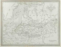
Etching on copper with colored borders.
Image dimension: 40x50.8 cm.
Unusual map of European Russia extending from the Gulf of Finland south to just before the Black Sea and the Caspian Sea.
It includes Finland, Poland and the Baltics.
Moscow is located at the bottom center, with topography and cities pictorially indicated. Only the western coast of Novaya Zemlya is shown.
First edition before the date and the coastline of Siberia, here still blank, features present in the updated edition of 1677.
Intact sheet with margins as original. Vertical binding fold in the center open at the bottom for a short stretch and with residue of codpiece on the back. Very slight yellowing at the ends.
- Creator:Pierre Duval-Lecamus (1790 - 1854, French)
- Creation Year:1676
- Dimensions:Height: 17.72 in (45 cm)Width: 22.84 in (58 cm)Depth: 0.04 in (1 mm)
- Medium:
- Movement & Style:
- Period:1670-1679
- Framing:Framing Options Available
- Condition:Insurance may be requested by customers as additional service, contact us for more information.
- Gallery Location:Roma, IT
- Reference Number:Seller: T-1532411stDibs: LU650315864052
About the Seller
4.9
Platinum Seller
Premium sellers with a 4.7+ rating and 24-hour response times
1stDibs seller since 2017
7,707 sales on 1stDibs
Typical response time: 2 hours
- ShippingRetrieving quote...Shipping from: Grasse, France
- Return Policy
Authenticity Guarantee
In the unlikely event there’s an issue with an item’s authenticity, contact us within 1 year for a full refund. DetailsMoney-Back Guarantee
If your item is not as described, is damaged in transit, or does not arrive, contact us within 7 days for a full refund. Details24-Hour Cancellation
You have a 24-hour grace period in which to reconsider your purchase, with no questions asked.Vetted Professional Sellers
Our world-class sellers must adhere to strict standards for service and quality, maintaining the integrity of our listings.Price-Match Guarantee
If you find that a seller listed the same item for a lower price elsewhere, we’ll match it.Trusted Global Delivery
Our best-in-class carrier network provides specialized shipping options worldwide, including custom delivery.More From This Seller
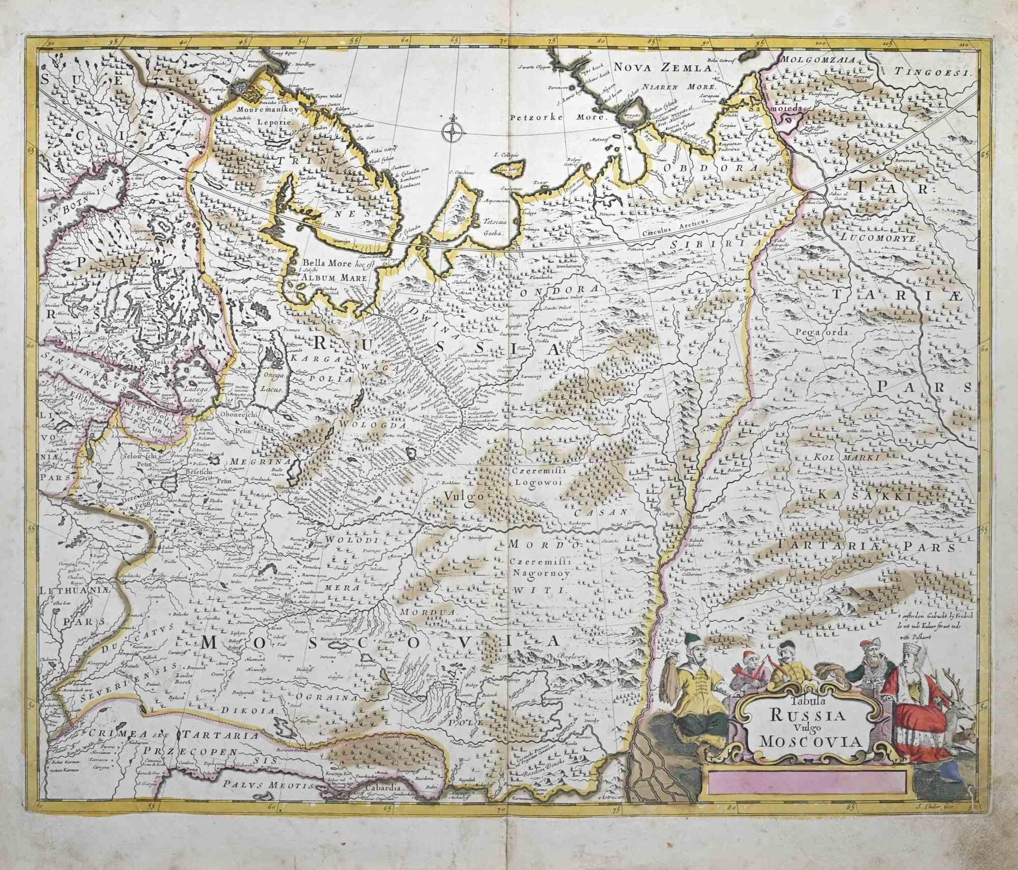
View AllTabula Russia Vulgo Moscovia - Etching by Frederick de Wit - 1680ca
By Frederick de Wit
Located in Roma, IT
This double-page etching with contemporary coloring, entitled Tabula Russia vulgo Moscovia, was realized by the cartographer Frederick de Wit for the famous Atlas published in Amster...
Category
1680s Modern Figurative Prints
Materials
Etching
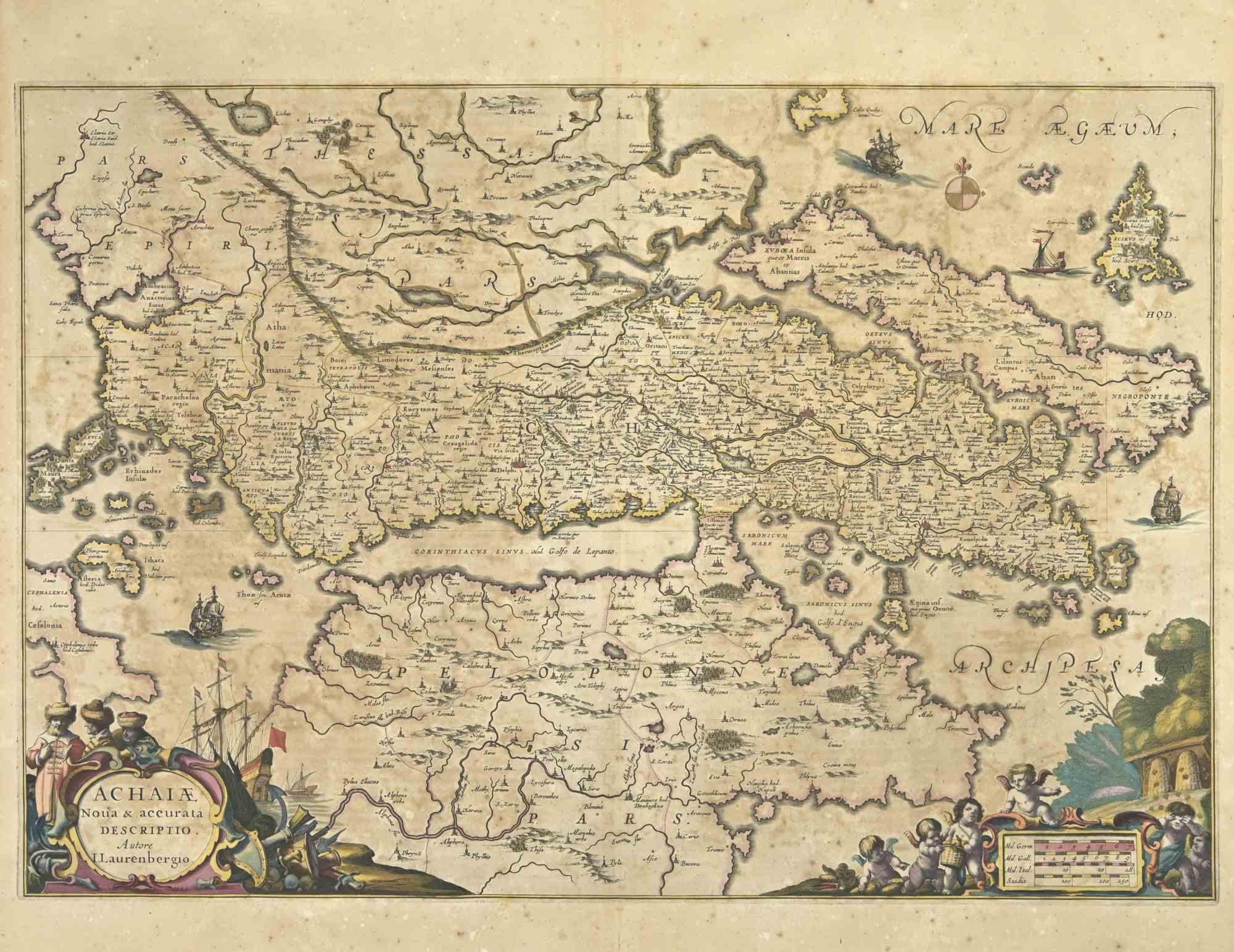
Achaiae Noua - Etching by Johannes Janssonius - 1650s
By Johannes Janssonius
Located in Roma, IT
Achaiae Noua is an ancient map realized in 1650 by Johannes Janssonius (1588-1664).
Good conditions.
From Atlantis majoris quinta pars, Orbem maritimum [Novus Atlas, volume V: cart...
Category
1650s Modern Figurative Prints
Materials
Etching
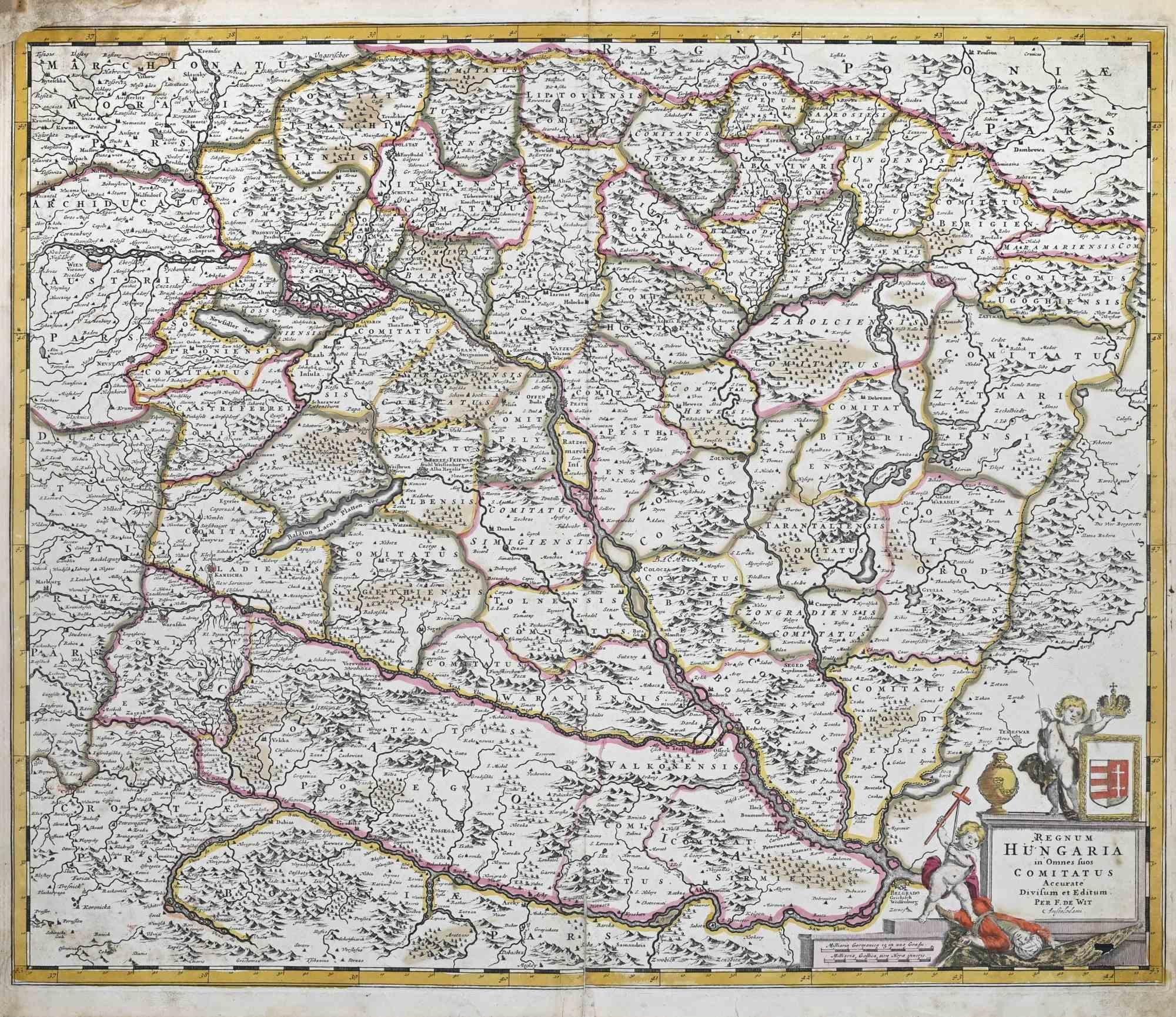
Regnum Hungariae - Etching by Frederick de Wit - 1680ca
By Frederick de Wit
Located in Roma, IT
This double-page etching with contemporary coloring, entitled Regnum Hungariae, was realized by the cartographer Frederick de Wit for the famous Atlas published in Amsterdam in ca. 1...
Category
1680s Modern Figurative Prints
Materials
Etching

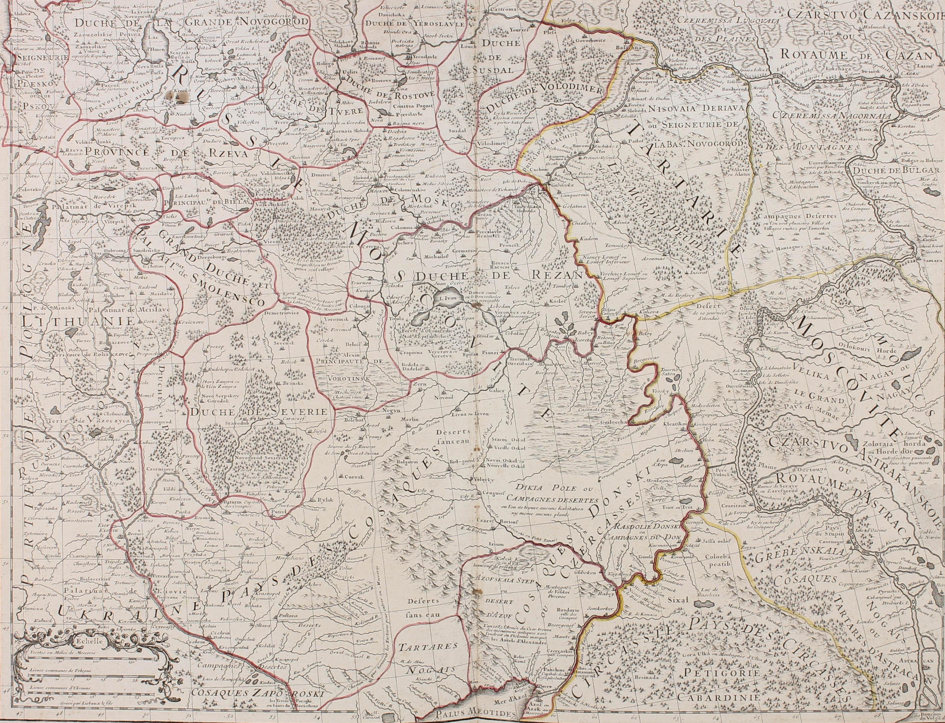
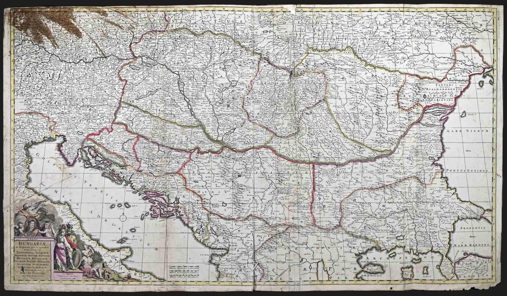
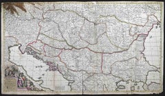
Regni Hungariae et Regionum - Etching by Frederick de Wit - 1680ca
By Frederick de Wit
Located in Roma, IT
This triple-page etching with contemporary coloring, entitled Regni Hungariae et Regionum, was realized by the cartographer Frederick de Wit for the famous Atlas published in Amsterd...
Category
1680s Modern Figurative Prints
Materials
Etching
Accuratissima Galliae Tabula - Etching by Frederick de Wit - 1680ca
By Frederick de Wit
Located in Roma, IT
This double-page etching with contemporary coloring, entitled Accuratissima Galliae Tabula [...], was realized by the cartographer Frederick de Wit for the famous Atlas published in ...
Category
1680s Modern Figurative Prints
Materials
Etching

Campagne de Russie - Etching by Pierre François Tardieu - 1837
Located in Roma, IT
Campagne de Russie is an Etching realized by Pierre François Tardieu in 1837.
Good conditions.
The artwork is realized in a well-balanced composition. the artwork and belongs to th...
Category
1830s Modern Figurative Prints
Materials
Lithograph
You May Also Like
Henri Liebaux and Guillaume De L'Isle - 1706 Engraving, Map Of The Moscovites
Located in Corsham, GB
A early 18th Century map showing a section of Muscovite Russia. This is the lower half of the complete original map, finished with hand colouring. The artist's names are engraved in ...
Category
18th Century More Prints
Materials
Engraving
Antique Map of Western Russia by Covens & Mortier, 1740
Located in Langweer, NL
Antique map titled 'Carte de Moscovie'. Antique map of the western portion of Russia. The map centers on Moscow (shown near the top of the lower sheet) and spans from the Sea of Azov...
Category
Antique Mid-18th Century Maps
Materials
Paper

$910 Sale Price
20% Off
Antique Map of Russia by N. Sanson, 1705
Located in Langweer, NL
A strongly engraved map of European Russia showing its political divisions, major topographical features, cities and towns. Extends to the Sea of Azov and the tip of the Caspian Sea ...
Category
Antique Early 18th Century Maps
Materials
Paper

$287 Sale Price
20% Off
Antique Map of the Region of Picardy by Janssonius, 1657
By Johannes Janssonius
Located in Langweer, NL
Antique map of France titled 'Picardia vera et inferior'. Detailed map of the Picardy region of France. This map originates from 'Atlas Novus, Sive Theatrum Orbis Orbis Terrarum: In ...
Category
Antique Mid-17th Century Maps
Materials
Paper

$479 Sale Price
20% Off
1714 Henri Chatelain "Nouvelle Carte Des Etatas Du Grand.Duc De Mos Moscovie Eur
Located in Norton, MA
A 1714 Henri Chatelain map, entitled
"Nouvelle Carte Des Etatas Du Grand Duc De Moscovie En Europe,"
Ricb001
Henri Abraham Chatelain (1684-1743) was a Huguenot pastor of Parisi...
Category
Antique Early 18th Century Dutch Maps
Materials
Paper

Antique Map of Beauce by Janssonius, 1657
By Johannes Janssonius
Located in Langweer, NL
Antique map 'Belsia vulgo la Beausse'. Decorative map of the region of Beauce, a natural region in northern France, located between the Seine and Loire rivers. This map originates fr...
Category
Antique Mid-17th Century Maps
Materials
Paper

$479 Sale Price
20% Off
More Ways To Browse
Picasso Picador Et Taureau
Picasso Satyr
Pierre Bonnard Signed
Pkz Posters
Rare Vintage Original Skate Decks
Rembrandt Etching Amsterdam
Renoir Hand Signed
Roger Jourdain
Rouault Passion
Roy Lichtenstein Composition
Roz Chast
Sally Michael
Salvador Dali Cerberus
Salvador Dali Ea
Salvador Dali Heart
Salvador Dali Moses
Sandu Liberman Lithograph
Scott Jacobs