Items Similar to Map of China - Etching - 19th Century


Want more images or videos?
Request additional images or videos from the seller
1 of 5
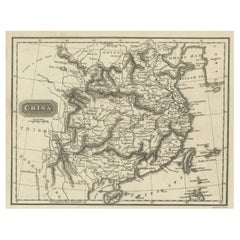
UnknownMap of China - Etching - 19th Century19th Century
19th Century
$294.73
£223.86
€250
CA$413.70
A$451.80
CHF 237.16
MX$5,418.91
NOK 2,986.85
SEK 2,805.80
DKK 1,904.13
About the Item
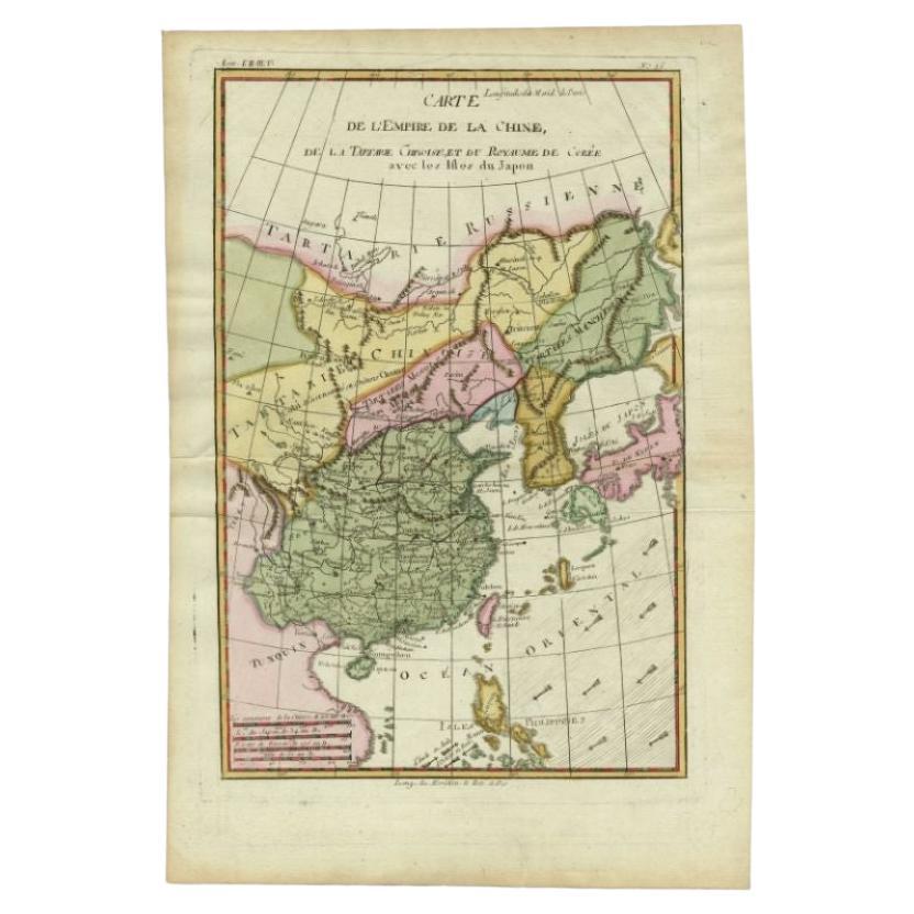
This map of China is an etching realized in 19th century.
The state of preservation of the artwork is excellent. At the top of the paper, the inscription “Longitudine del Meridiano dell'Isola del Ferro”, whilst at the bottom, just below the image, the inscription “Longitudine Est del Meridiano di Parigi”. At the top right, the number of the sheet "XXVI” is printed.
Image Dimensions: 26 x 20 cm
- Creation Year:19th Century
- Dimensions:Height: 18.51 in (47 cm)Width: 11.42 in (29 cm)Depth: 0.04 in (1 mm)
- Medium:
- Period:
- Framing:Framing Options Available
- Condition:Insurance may be requested by customers as additional service, contact us for more information.
- Gallery Location:Roma, IT
- Reference Number:Seller: M-1087221stDibs: LU65038033872
About the Seller
4.9
Platinum Seller
Premium sellers with a 4.7+ rating and 24-hour response times
1stDibs seller since 2017
7,795 sales on 1stDibs
Typical response time: 1 hour
- ShippingRetrieving quote...Shipping from: Grasse, France
- Return Policy
Authenticity Guarantee
In the unlikely event there’s an issue with an item’s authenticity, contact us within 1 year for a full refund. DetailsMoney-Back Guarantee
If your item is not as described, is damaged in transit, or does not arrive, contact us within 7 days for a full refund. Details24-Hour Cancellation
You have a 24-hour grace period in which to reconsider your purchase, with no questions asked.Vetted Professional Sellers
Our world-class sellers must adhere to strict standards for service and quality, maintaining the integrity of our listings.Price-Match Guarantee
If you find that a seller listed the same item for a lower price elsewhere, we’ll match it.Trusted Global Delivery
Our best-in-class carrier network provides specialized shipping options worldwide, including custom delivery.More From This Seller
View AllMap of Switzerland - Etching - 19th Century
Located in Roma, IT
This map of Netherlands is an etching realized in 19th century.
The state of preservation of the artwork is excellent. The signature "F.B." is engraved on the lower right. At the to...
Category
19th Century Figurative Prints
Materials
Etching

Map of the World - Original Etching - 1820
Located in Roma, IT
Map of the World is an Original Etching realized by an unknown artist of 19th century in 1820.
Very good condition on two sheets of white paper joine...
Category
1820s Modern Figurative Prints
Materials
Etching

Map of Russia - Etching by Marco Di Pietro - 19th Century
Located in Roma, IT
This map of Russia is an etching realized by the Italian engraver Marco Di Pietro in 19th century.
The state of preservation of the artwork is excellent. The signature is engraved o...
Category
19th Century Old Masters Figurative Prints
Materials
Etching
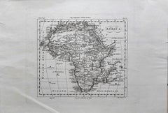
Ancient Map of Africa - Etching - 19th century
Located in Roma, IT
This Map of Africa is an etching realized in the 19th century.
The state of preservation of the artwork is good. At the top of the paper, the inscription “Longitudine del Meridiano ...
Category
19th Century More Prints
Materials
Etching
Map of Greece - Original Etching by Antonio Zatta - 18th Century
Located in Roma, IT
This Map of Greece is an etching realized by Antonio Zatta, Cartographer, publisher and typographer.
The state of preservation of the artwork is good except for the worn paper and t...
Category
1780s Figurative Prints
Materials
Etching

Map of Campaign of 1814 - Etching by Pierre François Tardieu - 1837
Located in Roma, IT
Map of Campaign of 1814 is an Etching realized by Pierre François Tardieu in 1837.
Good conditions.
The artwork is realized in a well-balanced composition. the artwork and belongs ...
Category
1830s Modern Figurative Prints
Materials
Lithograph

You May Also Like
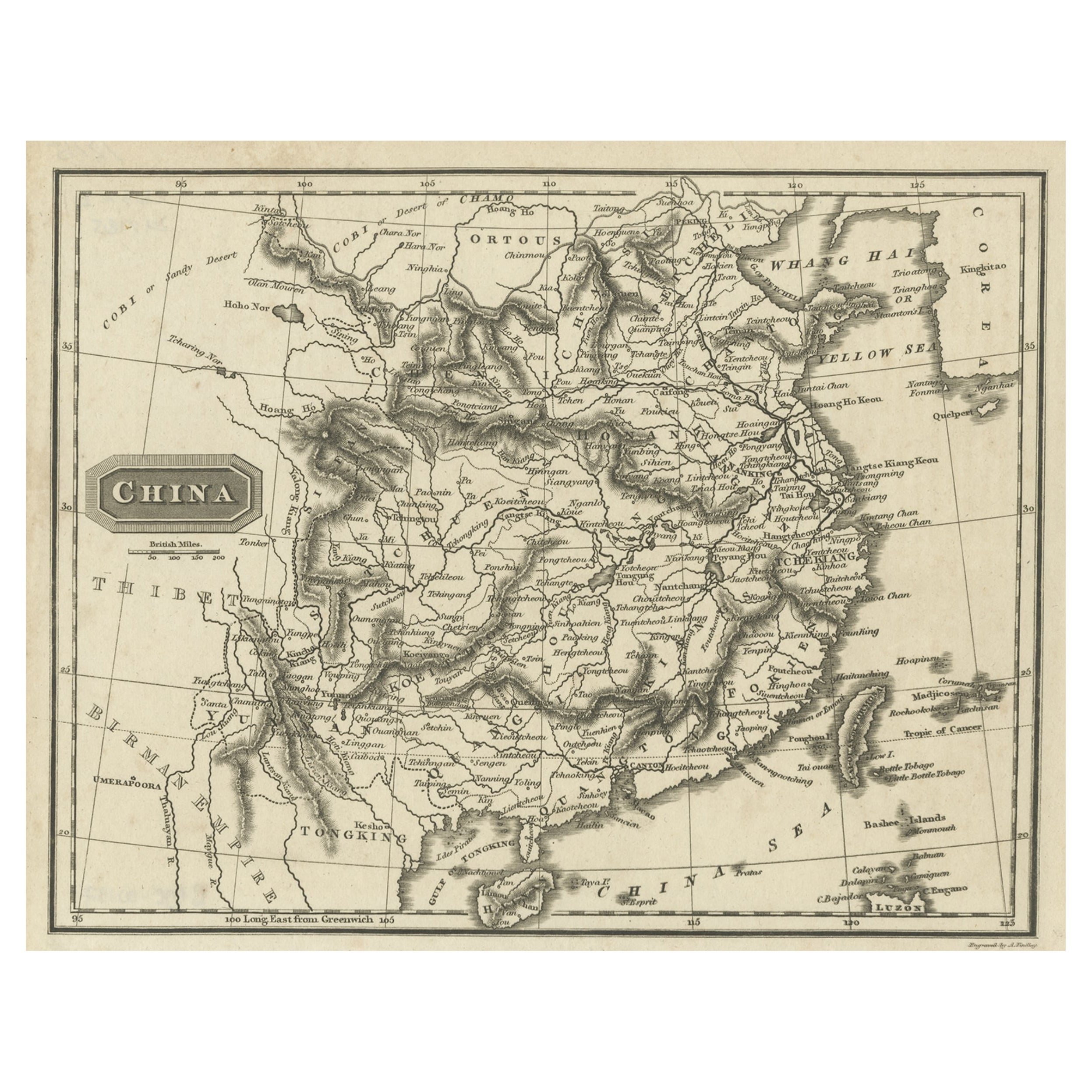
Old Map of the Mainland of China and the Islands of Formosa or Taiwan, c.1817
Located in Langweer, NL
Antique map titled 'China'. Old map of the mainland of China and the islands of Formosa or Taiwan. This map originates from 'Universal Geography' by T. Kelly.
Artists and Engrave...
Category
Antique 19th Century Maps
Materials
Paper
Antique Map of the Empire of China by Bonne, c.1780
By Rigobert Bonne
Located in Langweer, NL
Antique map titled 'Carte de L'Empire de la Chine.' Decorative map of the Empire of China, depicting China, Corea ( Korea ), Japan, Tonquin and the Philippine island Lucon. Source un...
Category
Antique 18th Century Maps
Materials
Paper

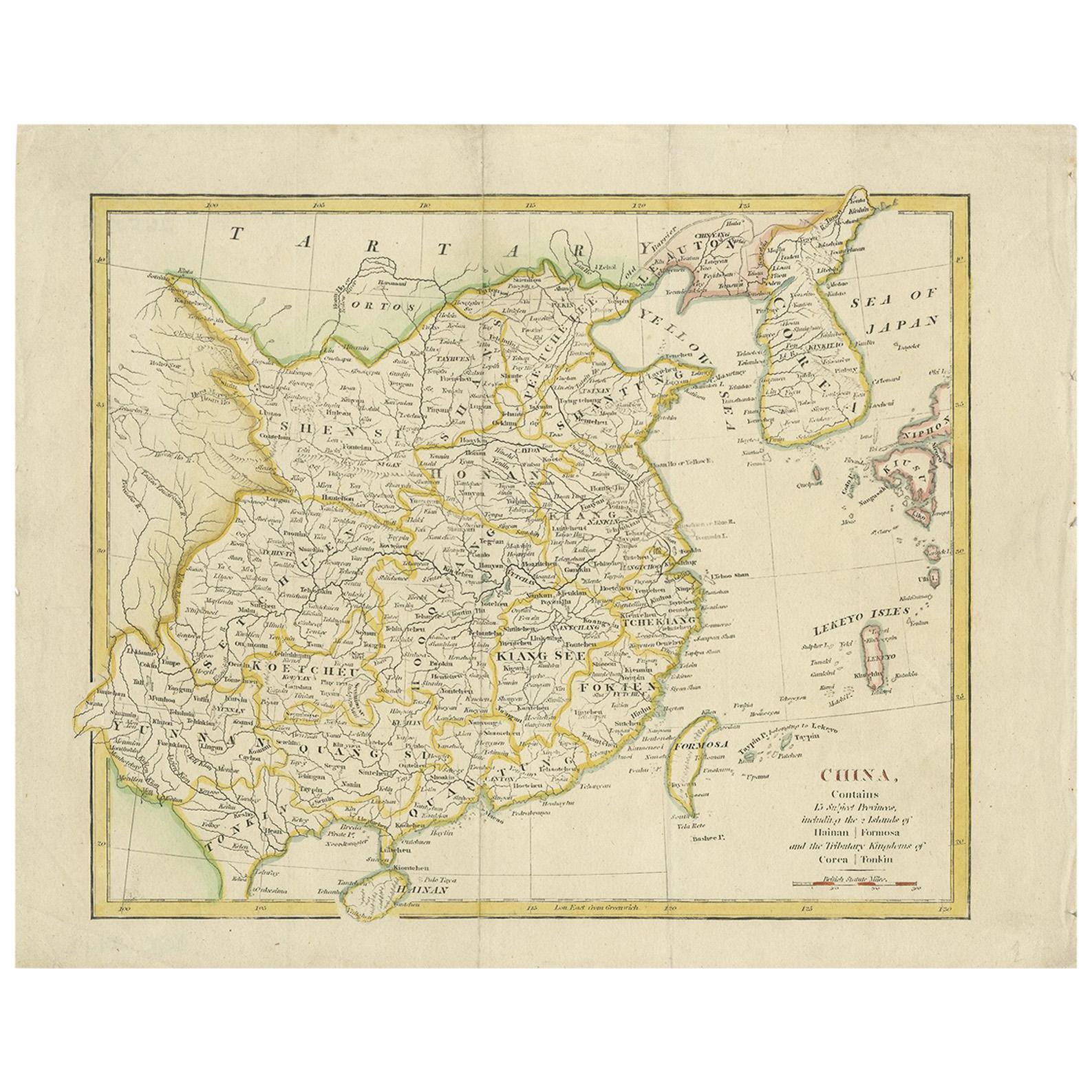
Antique Map of China by Wilkinson '1803'
Located in Langweer, NL
Antique map titled 'China, Contains 15 Subject Provinces Including the 2 Islands of Hainan, Formosa and the Tributary Kingdoms of Korea, Tonkin'. Old map depicting China, extending f...
Category
Antique Early 19th Century Maps
Materials
Paper

Original Antique Map of China, Arrowsmith, 1820
Located in St Annes, Lancashire
Great map of China
Drawn under the direction of Arrowsmith
Copper-plate engraving
Published by Longman, Hurst, Rees, Orme and Brown, 1820
Unfr...
Category
Antique 1820s English Maps
Materials
Paper

Antique Map of China by A & C, Black, 1870
Located in Langweer, NL
Antique map titled 'China'. Original antique map of China. This map originates from ‘Black's General Atlas of The World’. Published by A & C. Black, 1870.
Category
Antique Late 19th Century Maps
Materials
Paper

$259 Sale Price
20% Off
Antique Map of Asia by A. Blondeau, circa 1800
Located in Langweer, NL
This is a fine circa 1800 map of Asia by Alexandre Blondeau. It covers the entire continent from Africa and the Mediterranean east to the Bering Sea and south as far as Java and New ...
Category
Antique Early 19th Century Maps
Materials
Paper

More Ways To Browse
Penal Cross
Peter Doig Zermatt
Peter Forster
Peter Max 9 11
Peter Max Earth Day
Peter Max Friends
Peter Max Ladies
Peter Max World Cup
Peter Wever On Sale
Phyllis Lucas Gallery Old Print Center
Picasso 156 Series Etchings
Picasso 1970 100
Picasso Bacchus
Picasso Eau Forte
Picasso Erotic Art
Picasso Etching Femme Assise
Picasso Lamb
Picasso Lithograph Don Quixote