Want more images or videos?
Request additional images or videos from the seller
1 of 22
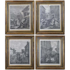
UnknownThree Engravings Depicting Sailing Yachts Competing in 1885 America's Cup Trials1885
1885
$2,875List Price
About the Item
About the Seller
5.0
Platinum Seller
Premium sellers with a 4.7+ rating and 24-hour response times
Established in 2011
1stDibs seller since 2019
299 sales on 1stDibs
Typical response time: 1 hour
Authenticity Guarantee
In the unlikely event there’s an issue with an item’s authenticity, contact us within 1 year for a full refund. DetailsMoney-Back Guarantee
If your item is not as described, is damaged in transit, or does not arrive, contact us within 7 days for a full refund. Details24-Hour Cancellation
You have a 24-hour grace period in which to reconsider your purchase, with no questions asked.Vetted Professional Sellers
Our world-class sellers must adhere to strict standards for service and quality, maintaining the integrity of our listings.Price-Match Guarantee
If you find that a seller listed the same item for a lower price elsewhere, we’ll match it.Trusted Global Delivery
Our best-in-class carrier network provides specialized shipping options worldwide, including custom delivery.You May Also Like
1776 Navigational chart/map of the Delaware bay and river including Philadelphia
Located in Philadelphia, PA
JOSHUA FISHER
(AMERICAN, EIGHTEENTH CENTURY)
A Chart of Delaware Bay and River, 1776
Printed for John Bennet and Robert Sayer, London
Engraving on pape...
Category
1770s Realist Landscape Prints
Materials
Paper, Engraving

$5,000
H 19.5 in W 28.25 in
Plan of the Park, Garden and Plantations of Goodwood, 18th century engraving
By Colen Campbell
Located in Melbourne, Victoria
Plan of the Park, Garden and Plantations of Goodwood in Sussex the Seat of his Grace the Duke of Richmond and Lenox &c
Copper-line engraving with later hand-colouring by Hendrik Hul...
Category
18th Century English School Landscape Prints
Materials
Engraving
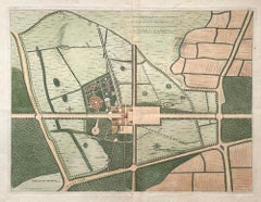
$450
H 21.26 in W 27.56 in
Les Bergers Romains, landscape with Roman ruins, 18th century engraving
Located in Melbourne, Victoria
Les Bergers Romains
Copper-line engraving by Jean Jacques Leveau (1729-1786) after Pierre Mettay (1728-1759). C1755.
Proof, before lettering. Laid, watermarked paper.
A landscap...
Category
18th Century French School Landscape Prints
Materials
Engraving
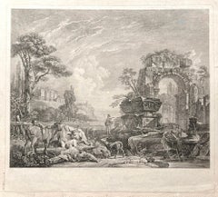
$980
H 17.33 in W 19.3 in
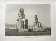
Colossi of Memnon, Thebes, Egypt. Early 19th century engraving, 1820
Located in Melbourne, Victoria
'Vue des Deux Colosses. Thebes, Memnonium'
Elephant folio engraving, by Baltard after Dutetre, from 'Description de l'Egypte', published after Napoleon's expedition to colonize Egyp...
Category
Early 19th Century Other Art Style Landscape Prints
Materials
Engraving
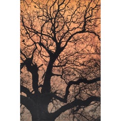
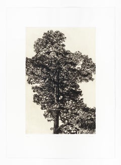
Autumn Pine, Limited edition print, Landscape, Tree, Nature art
By Fiona Hamilton
Located in Deddington, GB
This print of a pine tree uses kitakata Japanese tissue chine collé to depict the warmth and colour of early autumnal light. It is then backed onto Hahnemule printmaking paper. The subject matter is from Ashton Court Estate in Bristol. This body of work is based on the book by Suzanne Simard, 'Finding the Mother Tree'. Trees communicate via mycorrhizal fungi to trade water and other nutrients. Ancient and mature trees nurture their offspring via these networks, as well as trading nutrients between other species. Botanist Simard has spent years working on this theory as part of a wider body of work, discovering what it means for forests, the climate and the wider Anthropocene. My work explores the ecological sublime and an appreciation of the majesty of nature. I use detailed intaglio etching, drypoint, lithography and chine collé to draw the viewer into an ethereal landscape that has an impact on our sense of place in relation to the natural world. I use primarily black and white with natural tones of chine collé and sometimes layers of lithographic texture to introduce warmth to the stark palette and to invoke a sublime emotional connection. I work from sketches, photographs, notes and memory to create my prints.
ADDITIONAL INFORMATION:
Black & White, Chine Collé, Drypoint, Drypoint print, Etching, Etching print on Paper
Edition of 20
44 H x 32 W x 1 D cm (17.32 x 12.60 x 0.39 in)
Sold unframed
Image size:
Height: 30cm (11.81 in)
Width: 20cm (7.87 in)
Complete size of sheet
Height: 44cm (17.32 in)
Width: 32cm (12.60 in)
Depth: 1cm (0.39 in)
ARTIST BIOGRAPHY:
Fiona Hamilton is a printmaker based in Bristol. Interested in process she uses a combination of mediums, both traditional and contemporary, to produce unique imagery, often as one off pieces or in small limited editions. She currently works in silkscreen, cyanotype and foil.
Fiona’s artwork draws on a lot of natural themes such as plants, leaves, trees and creatures including lots of birds. She mostly works directly from nature or from photographs she has taken. She regularly lugs a heavy telephoto lens about to get photos of birds...
Category
2010s Contemporary Landscape Prints
Materials
Drypoint, Etching
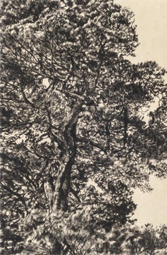
$268
H 17.33 in W 12.6 in D 0.4 in
Branches Gold, Limited edition print, Landscape, Tree, Nature art
By Fiona Hamilton
Located in Deddington, GB
Scots Pine drypoint etching printed onto Japanese gampi tissue and backed onto German Hahnemule printmaking paper. This print depicts a mature pine tree, standing proud from the rest...
Category
2010s Contemporary Landscape Prints
Materials
Drypoint, Etching
$103
H 22.05 in W 14.97 in D 0.4 in
Winter Chestnut, Limited edition print, Landscape, Tree, Nature art
By Fiona Hamilton
Located in Deddington, GB
Scots Pine drypoint etching printed onto Japanese gampi tissue and backed onto German Hahnemule printmaking paper. This print depicts a mature pine tree, standing proud from the rest...
Category
2010s Contemporary Landscape Prints
Materials
Drypoint, Etching
$240
H 24.81 in W 18.12 in D 0.4 in
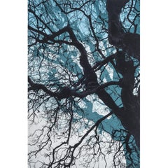
Branches Blue, Limited edition print, Landscape, Tree, Nature art
By Fiona Hamilton
Located in Deddington, GB
This print is part of a small series of works to investigate the use of layering, colour blends and texture in screen print to elicit an ethereal, eerie and potentially dizzying sens...
Category
2010s Contemporary Landscape Prints
Materials
Drypoint, Etching
$103
H 22.05 in W 14.97 in D 0.4 in
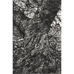
Greville Smyth Pine, Limited edition print, Landscape, Tree, Nature art
By Fiona Hamilton
Located in Deddington, GB
A very detailed drypoint etching of a Pine tree printed onto gampi Japanese tissue and backed onto Hahnemule printmaking paper. This print considers how we view the contemporary sublime landscape and how easy it can be to experience when we take the time to look. We often don’t have to travel far: parks in cities, the coastline and stars in the night sky. The mature Scots Pine tree pictured...
Category
2010s Contemporary Landscape Prints
Materials
Drypoint, Etching
$392
H 24.81 in W 18.12 in D 0.4 in
Scots Pine, Limited edition print, Landscape, Tree, Nature art
By Fiona Hamilton
Located in Deddington, GB
Scots Pine drypoint etching printed onto Japanese gampi tissue and backed onto German Hahnemule printmaking paper. This print depicts a mature pine tree, standing proud from the rest...
Category
2010s Contemporary Landscape Prints
Materials
Drypoint, Etching
$337
H 24.81 in W 18.12 in D 0.4 in
More From This Seller
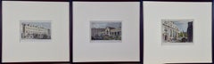
View AllThree 19th C. Hand Colored Engravings of London Architecture by T. Shepherd
By Thomas Hosmer Shepherd
Located in Alamo, CA
A set of three hand-colored engravings from "Metropolitan Improvements; or London in the Nineteenth Century", published in London, England in 1828. The scenes were drawn by Thomas Ho...
Category
1820s Realist Landscape Prints
Materials
Engraving
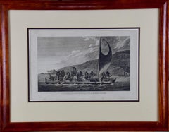
Sandwich Islands Canoe (Hawaii): Framed 18th C. Engraving Captain Cook's Journal
By John Webber
Located in Alamo, CA
"A Canoe of the Sandwich Islands, the Rowers Masked" is an engraving created by Charles Grignion, from a drawing by John Webber (1752-1793), who was the artist on Captain James Cook's 3rd and final voyage of discovery. It is Plate 65 in the atlas of "A Voyage to the Pacific Ocean Undertaken by the Command of His Majesty, for Making Discoveries in the Northern Hemisphere", the official British Admiralty sanctioned journal published upon completion of the voyage in London in 1784 by Strahan & Cadell.
This famous image of ten Hawaiian rowers transporting a priest who is carrying a feather-covered image of Kukailimoku, the Hawaiian god of war. The priests and paddlers are all wearing gourd masks in their double-hulled canoe with an upright lateen woven sail. Each hull was shaped from a single large Koa log harvested from island rainforests, where they were carved before being transported to the coast.
This engraving is presented in a Koa wood frame and a white mat. There are occasional faint spots, but the print is otherwise in very good condition. Koa is the same wood as was used to make the canoe. Koa wood is legendary in Hawaii. Not only is this amazing wood native to Hawaii, but it is known for the deep rich colors and varied grain pattern. Koa has an honored heritage in Hawaii and is highly revered and sacred. The word “koa” means “warrior” in Hawaiian. The warriors of King Kamehameha the Great, created canoes and weapons from a wood plentiful on the Big Island of Hawaii. This wood became synonymous with the warriors themselves, and it became known as koa. The frame measures 20.75" high, 26.75" wide and 0.88" deep.
There are three other engravings listed from the official journal of Captain Cook's 3rd voyage available that are presented in identical Koa wood frames and mat (LU117324682022, LU117324684052, LU117324684062). They would make a wonderful grouping for a display of 2, 3 or 4 prints. A discount is available for a grouping depending on the number of items included.
Hawaii was discovered by Captain Cook (1728-1779) during this voyage. Hawaii was originally called The Sandwich Islands in honor of The Earl of Sandwich...
Category
1780s Landscape Prints
Materials
Engraving
Map of the Holy Land "Carte de la Syrie et de l'Egypte" by Pierre Lapie
By Pierre M. Lapie
Located in Alamo, CA
This is an early 19th century map of ancient Syria and Egypt entitled "Carte de la Syrie et de l'Egypte anciennes/dressée par M. Lapie, Colonel d'Etat M...
Category
1830s Landscape Prints
Materials
Engraving

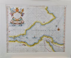
Edinburgh, Scotland: An Original 17th C. Hand-Colored Engraved Sea Chart
By Captain Greenvile Collins
Located in Alamo, CA
This hand-colored sea chart is entitled "Edinburgh Firth" from "Great Britain's Coasting Pilot. Being a New and Exact Survey of the Sea-Coast of England" by Captain Greenville Collin...
Category
Late 17th Century Landscape Prints
Materials
Engraving
Four Framed Hogarth Engravings "Four Times of the Day"
By William Hogarth
Located in Alamo, CA
The four plates in this "Four Times of the Day" set were created utilizing both engraving and etching techniques by William Hogarth in 1738. Hogarth's original copper plates were refurbished where needed by James Heath and these engravings were republished in London in 1822 by Braddock, Cradock & Joy. This was the last time Hogarth's original copper plates were used for printing. Most were melted down during World War I for the construction of bombs. Printed upon early nineteenth century wove paper and with large, full margins as published by William Heath in 1822. The inscription below each print reads "Invented Painted & Engraved by Wm. Hogarth & Publish'd March 25. 1738 according to Act of Parliament".
These large folio sized "Four Times of the Day" engravings/etchings are presented in complex gold-colored wood frames with black bands and scalloped gold inner trim. A majority of each thick impressive frame is covered with glass applied near the outer edge. Each frame measures 25.75" high, 22.25" wide and 1.88" deep. There are a few small dents in the edge of these frames, which are otherwise in very good condition. "Morning" has two focal areas of discoloration in the upper margin and some discoloration in the right margin, a short tear in the left margin and a short tear or crease in the right margin. "Noon" has a spot in the upper margin that extends into the upper image, but it is otherwise in very good condition. "Evening" has a faint spot in the upper margin, but it is otherwise in very good condition. "Night" is in excellent condition.
The "Four Times of the Day" series is in the collection of many major museums, including: The British Museum, The Metropolitan Museum of Art, The Tate Museum, The Chicago Art Institute and The Victoria and Albert Museum.
Through this series Hogarth is portraying early 18th century London street life at "Four Times of the Day". His characters are exhibiting their personalities, quircks, strange activities, but he also wants to draw attention the disparities between the wealthy aristocracy and the common working class.
Plate 1, "Morning" depicts morning in Covent Garden in the winter in front of Tom King...
Category
Mid-18th Century Old Masters Landscape Prints
Materials
Engraving, Etching
$5,420 Sale Price
20% Off
Spain and Portugal: A Hand-colored 17th/18th Century Map by Visscher
By Nicolaus Visscher
Located in Alamo, CA
This is an early 18th century map of Spain and Portugal, with attractive original hand-coloring, entitled "Hispaniae et Portugalliae Regna per Nicolaum Visscher cum Privilegio Ordinum Hollandiae et Westfrisiae" first published by Nicolaes Visscher II (1649-1702) in 1688, and later re-published from Visscher's original copper plate by Peter Schenk, Junior in Amsterdam in 1725. The cartouche in the right lower corner depicts a coat of arms representing one combined kingdom of Spain and Portugal before their break-up. Putti hold up the coat-of-arms of Phillip II on the right and a queen reaches for it on the left. There is a scale cartouche in the lower left corner surmounted by two putti and a wheel. This is an outstanding depiction of the Iberian peninsula, showing Spain and Portugal and Balearic Islands. The map includes portions of North Africa and the Strait of Gibralter.
This copperplate engraved map is presented in a cream-colored mat. It is printed on fine chain-linked, laid paper. The mat measures 26.5" high by 30" wide and the sheet measures 21.75" high by 26.375" wide. There is a central fold, as issued. The lower portion of the fold is reinforced on the verso. There is a small paper defect at the lower edge of the fold and another at the edge of the right corner, as well as a few small tears along the lower edge; none affecting the map and all covered by the mat. There are a few small faint spots in the upper margin and on the left. The map is otherwise in very good condition.
The Visscher family were one of the great art and cartographic printing families of the 17th century. Begun by Claes Jansz Visscher...
Category
Late 17th Century Other Art Style Landscape Prints
Materials
Engraving

$1,020 Sale Price
20% Off