Items Similar to John Senex (1678-1740) - 18th Century Engraving, A New Map of Great Britain


Want more images or videos?
Request additional images or videos from the seller
1 of 8
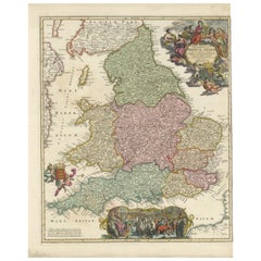
John SenexJohn Senex (1678-1740) - 18th Century Engraving, A New Map of Great Britain18th Century
18th Century
$867
£656.28
€752.76
CA$1,218.66
A$1,341.13
CHF 703.27
MX$16,275.84
NOK 8,790.78
SEK 8,322.44
DKK 5,619.72
About the Item
A New Map of Great Britain - Corrected from the Observations Communicated to the Royal Society at London. By John Senex F.R.S. A double-page engraved map on 2 sheets joined, with later hand-colouring. Well presented in a beautiful, heavy oak frame. Glazed. On laid.
- Creator:
- Creation Year:18th Century
- Dimensions:Height: 40.16 in (102 cm)Width: 28.75 in (73 cm)
- Medium:
- Period:
- Condition:The engraving has been trimmed within the plate. Previous cleaning attempts caused bleaching on the left edge. There is notable discoloration, fine creases across the surface, and light wear to the heavy oak frame.
- Gallery Location:Corsham, GB
- Reference Number:Seller: sk4161stDibs: LU881315801202
About the Seller
4.9
Platinum Seller
Premium sellers with a 4.7+ rating and 24-hour response times
Established in 2010
1stDibs seller since 2018
1,357 sales on 1stDibs
Typical response time: 2 hours
- ShippingRetrieving quote...Shipping from: Corsham, United Kingdom
- Return Policy
Authenticity Guarantee
In the unlikely event there’s an issue with an item’s authenticity, contact us within 1 year for a full refund. DetailsMoney-Back Guarantee
If your item is not as described, is damaged in transit, or does not arrive, contact us within 7 days for a full refund. Details24-Hour Cancellation
You have a 24-hour grace period in which to reconsider your purchase, with no questions asked.Vetted Professional Sellers
Our world-class sellers must adhere to strict standards for service and quality, maintaining the integrity of our listings.Price-Match Guarantee
If you find that a seller listed the same item for a lower price elsewhere, we’ll match it.Trusted Global Delivery
Our best-in-class carrier network provides specialized shipping options worldwide, including custom delivery.More From This Seller
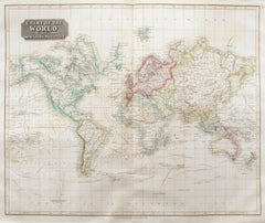
View AllJohn Thomson (1777-1840) - 1830 Map Engraving, Chart of the World
By John Thomson
Located in Corsham, GB
A fine engraved map of the world on Mercator's projection, from the second edition of John Thomson's 'New General Atlas' published in 1830. On paper.
Category
Early 19th Century More Prints
Materials
Engraving
$316 Sale Price
20% Off
After Johann B. Homann (1664-1724) - 19th C, General Map of Spain and Portugal
Located in Corsham, GB
General map of Spain and Portugal divided into its current provinces by D.T. Lopez, newly drawn by F. L. G. in Nuremberg at the Heret of Homann, 1782. A double-page engraved map with...
Category
19th Century More Prints
Materials
Engraving

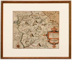
Christopher Saxton & William Kip - Framed 17th Century Engraving, Merionith
Located in Corsham, GB
An early copper-engraved county map of Merioneth, based on the work of Christopher Saxton (1540-1610), and engraved by William Kip (fl.1598-1610) for William Camden's 'Britannia'. Wi...
Category
18th Century More Prints
Materials
Engraving
John Thomson (1777-1840) - 1830 Map Engraving, The Rivers of the World
By John Thomson
Located in Corsham, GB
A fine engraved chart table showing the lengths of the principal rivers across the world, from the second edition of John Thomson's 'New General Atlas' published in 1830. On paper.
Category
Early 19th Century More Prints
Materials
Engraving
$349 Sale Price
20% Off
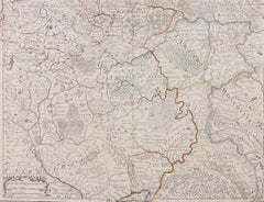
Henri Liebaux and Guillaume De L'Isle - 1706 Engraving, Map Of The Moscovites
Located in Corsham, GB
A early 18th Century map showing a section of Muscovite Russia. This is the lower half of the complete original map, finished with hand colouring. The artist's names are engraved in ...
Category
18th Century More Prints
Materials
Engraving
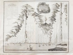
18th Century Map Engraving - Newport, a Strong Sea-Port Town in Flanders
Located in Corsham, GB
A map of Nieuwpoort, anglicised to 'Newport', in northern Belgium. There is a panorama in the upper quarter depicting major landmarks. Below is a plan of the town, including its strong defences and ships at the port in the lower register. Inscribed with the title in plate to the lower edge, 'Newport a Strong Sea-Port Town...
Category
18th Century More Prints
Materials
Engraving

$269 Sale Price
20% Off
You May Also Like
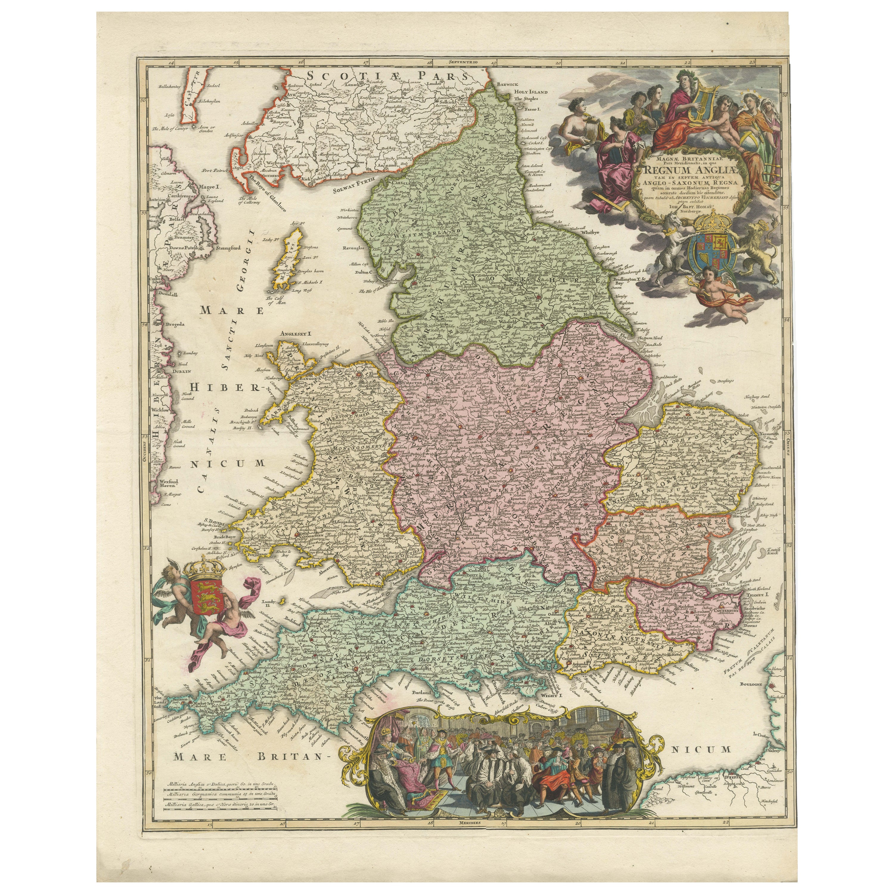
Rare 1690 Map of England by Nicolaes Visscher II – Heptarchy Depicted
Located in Langweer, NL
Map of England 1690 by Nicolaes Visscher II – Heptarchy and Counties Shown
Antique 1690 map of England by Nicolaes Visscher II, showing the Anglo-Saxon Heptarchy and detailed county...
Category
Antique Late 17th Century Dutch Maps
Materials
Paper
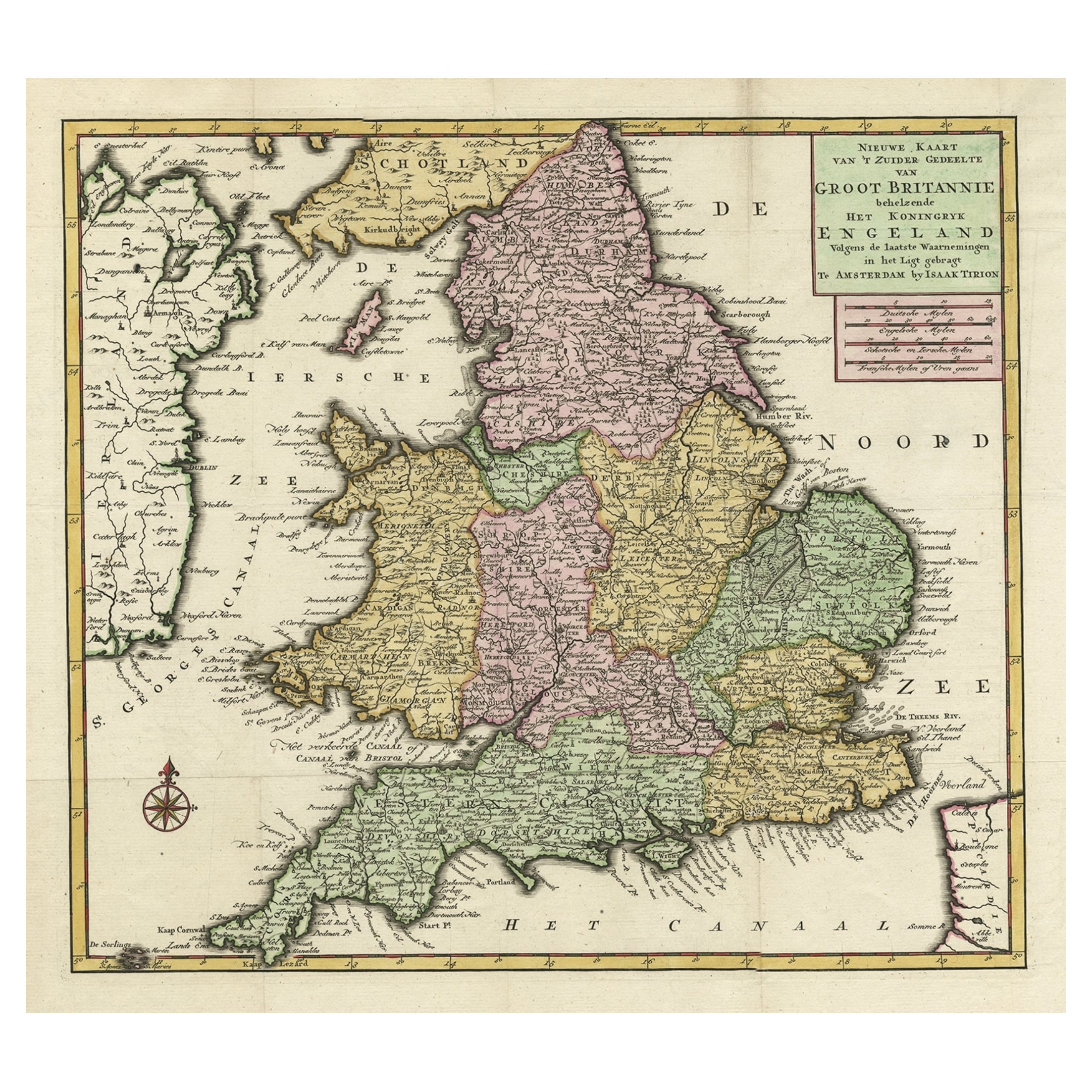
Antique Map of the South Part of Great Britain by Tirion, c.1750
By Isaak Tirion
Located in Langweer, NL
Antique map titled 'Nieuwe Kaart van 'T Zuider Gedeelte van Groot Britannie behelzende Het Koningryk Engeland (..).'
Attractive map showing the south part of Great Britain; the K...
Category
Antique 18th Century Maps
Materials
Paper
$431 Sale Price
20% Off
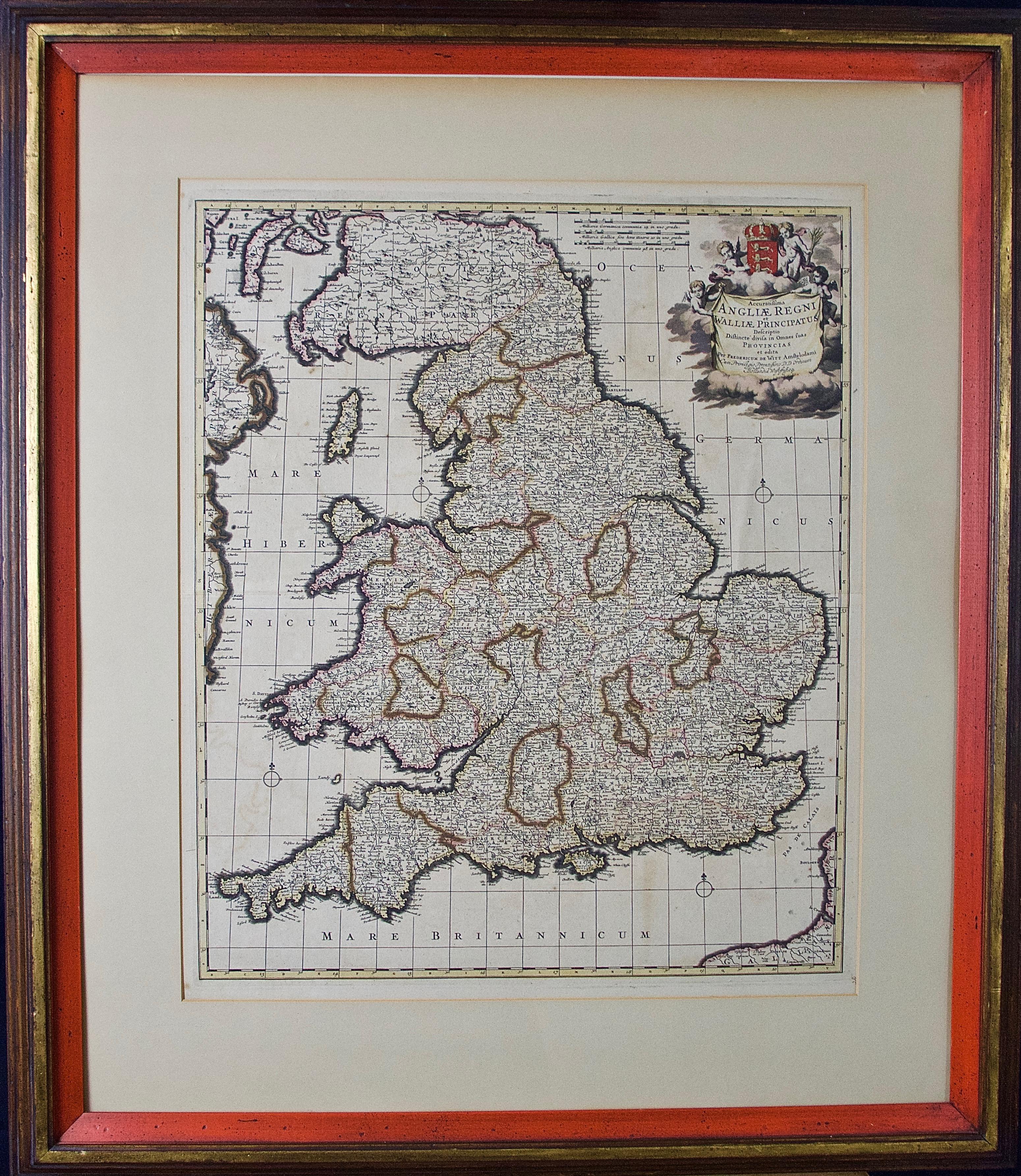
England and the British Isles: A Large 17th Century Hand-colored Map by de Wit
By Frederick de Wit
Located in Alamo, CA
This is a large hand-colored 17th century map of England and the British Isles by Frederick de Wit entitled "Accuratissima Angliæ Regni et Walliæ Principatus", published in Amsterdam in 1680. It is a highly detailed map of England, Scotland, the Scottish Isles...
Category
Late 17th Century Other Art Style Landscape Prints
Materials
Engraving

Antique Map of the British Isles by Covens & Mortier, 1730
By Covens & Mortier
Located in Langweer, NL
Covens and Mortier's attractive double-page engraved map of the British Isles, based on the 1702 De L'Isle map. The map features a large car...
Category
Antique Mid-18th Century Maps
Materials
Paper

$623 Sale Price
20% Off
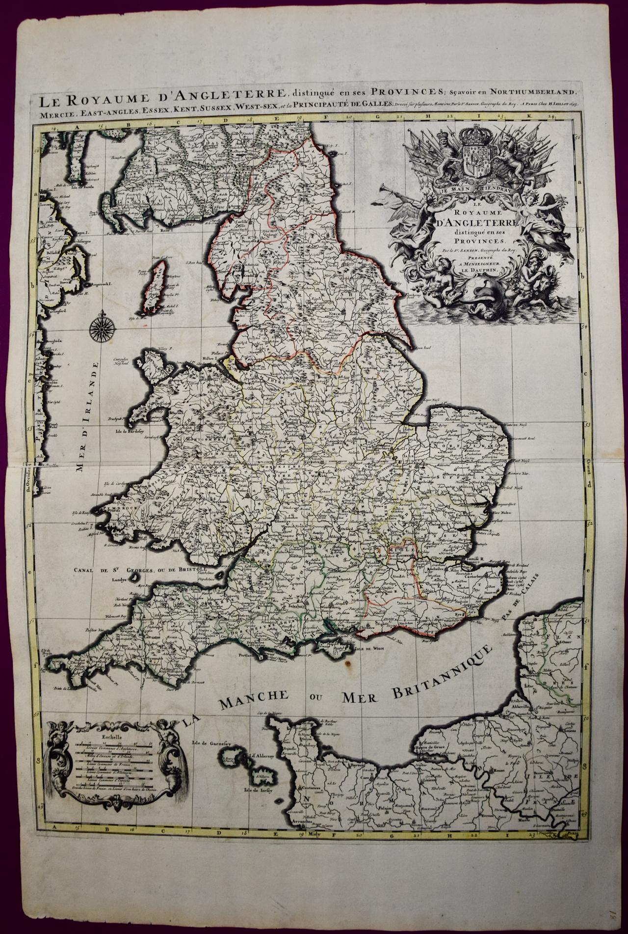
Great Britain, N. France: A Large 17th C. Hand-colored Map by Sanson and Jaillot
By Nicholas Sanson d'Abbeville
Located in Alamo, CA
This large hand-colored 17th century copperplate engraved map entitled "Le Royaume D Angleterre, distingué en ses Provinces. Par le Sr. Sanson. Geographe du Roy. Presenté A Monseigne...
Category
1690s Landscape Prints
Materials
Engraving

Antique Map of the British Isles by H. Chatelain, 1719
By Henri-Abraham Chatelain
Located in Langweer, NL
Beautiful hand colored large format map of the British Isles, with large insets of the Eastern and Western Hemispheres and the coats of arms for Engl...
Category
Antique Early 18th Century Maps
Materials
Paper

$718 Sale Price
20% Off
More Ways To Browse
Map Of Britain
Antique Maps Of Britain
Poster Futbol Vintage
Priceless Oil
Rallye Monte Carlo
Sandra Fisher
Shepard Fairey Money
Us Army Poster
Vintage American Football Posters
Vintage Beetle Print
Vintage Campari Prints
Vintage Farm Tractors
Vintage Football Prints
Vintage Hindu Posters
Vintage Ski Poster Sweden
Vintage Surf Art
Vintage Wimbledon Posters
White Star Line Poster