
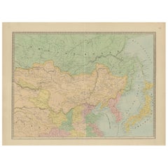
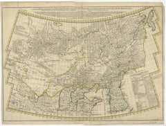
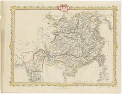
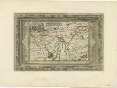
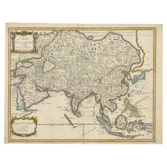
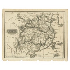
Antique Map of Northern China and Eastern Russia by Bellin, 1757
Located in Langweer, NL
Original antique map of what is present day northern China and far eastern Russia.
Category
Antique 18th Century Maps
Materials
Paper
Antique Map of Northern China and Eastern Russia by Bellin, 1757
Located in Langweer, NL
Original antique map of what is present day northern China and far eastern Russia.
Paper
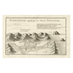
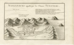
Antique Map of Nagasaki – Nangasacki Called Tchangki by the Chinese, circa 1790
Located in Langweer, NL
Map of Nagasaki – “Nangasacki appellé par les Chinois Tchangki”, c.1760 This finely engraved 18th-century map depicts the Japanese port city of Nagasaki (Nangasacki), here noted as ...
Paper
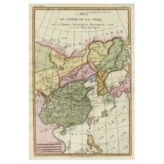
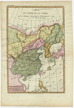
Antique Map of China, Japan & Korea – Eastern Asia by Andriveau-Goujon, 1860
Located in Langweer, NL
Antique Map of China, Japan & Korea – Eastern Asia by Andriveau-Goujon, 1860 This beautifully hand-colored antique map, titled “Carte de la Chine, de la Corée et du Japon,” was publ...
Paper
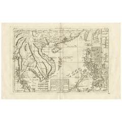
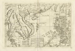
The Philippines & Southeast Asia – Bonne’s Antique Map of Indo-China, c.1780
Located in Langweer, NL
French Indian Ocean Islands – Bourbon, Isle de France & Rodrigues, Bonne c.1780 Description: This finely engraved 18th-century map depicts the key French-controlled islands of t...
Paper

Super Rare Antique French Map of Chine and the Chinese Empire, 1780
Located in Amsterdam, Noord Holland
Super Rare Antique French Map of Chine and the Chinese Empire, 1780 Very nice map of Asia. 1780 Made by Bonne.
Paper
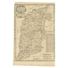
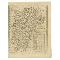
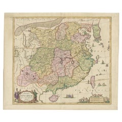
Antique Map of the Shanxi Province of China by Du Halde, 1738
Located in Langweer, NL
Antique map titled 'Province IX Shan-Si'. Old map depicting the Shanxi province of China.
Paper
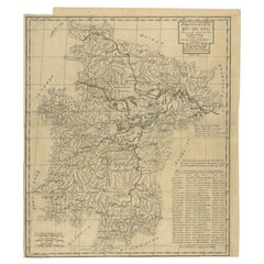
Antique Map of the Huguang Province of China by Du Halde, 1738
Located in Langweer, NL
Antique map titled 'Province VI Hu-Quang'. Old map depicting the Huguang province of China.
Paper

Antique Map of the Jiangxi Province of China by Du Halde, 1738
Located in Langweer, NL
Antique map titled 'Province III Kyang-Si'. Old map depicting the Jiangxi province of China.
Paper
$2,557Sale Price|20% Off
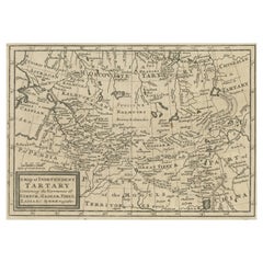
Rare Hand-Colored Antique Map of Tartary, China and Korea, ca.1741
Located in Langweer, NL
Rare antique map of Tartary, China and Korea. Includes a nice detail of Korea, Japan and China, along with a detailed chart explaining the subdivisions within Tartary.
Paper
$744Sale Price|20% Off
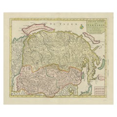
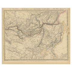
Antique Map op Siberia and Chinese Tartary with original hand coloring, 1732
Located in Langweer, NL
Map op Siberia and Chinese tartary. In the north Novaya Zemlya curls back to attach itself to the mainland by a narrow isthmus.
Paper


Antique Map of China, Korea, Japan and the Northern Philippines, circa 1780
Located in Langweer, NL
Interesting and detailed map of China, Korea, Japan and the Northern Philippines.
Paper

$204Sale Price|20% Off
Antique Map of Asia with the Porcelain Tower at Nanjing, China, 1884
Located in Langweer, NL
Antique map titled 'Asie'. Map of the Asian continent, with an illustration of the porcelain tower at Nanjing, China.
Paper
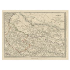
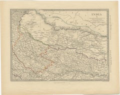
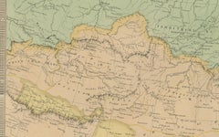
Original Old Map Northeast India, incl Part of Himalayas and China, 1853
Located in Langweer, NL
Antique map titled 'India X'. Old map of the the northeast region of India, including part of Himalayas and China.
Paper
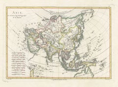
Elegant 18th Century Map of Asia by Rigobert Bonne Showing Siberia & China, 1787
Located in Langweer, NL
Elegant 18th Century Map of Asia by Rigobert Bonne Showing Siberia and China Description: This elegant late eighteenth-century map titled Asie was engraved by the celebrated French ...
Paper
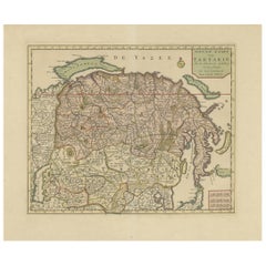

Antique Map of Siberia and Chinese Tartary, Incl Nova Zembla, ca.1732
Located in Langweer, NL
Map op Siberia and Chinese tartary. In the north Novaya Zemlya curls back to attach itself to the mainland by a narrow isthmus.
Paper


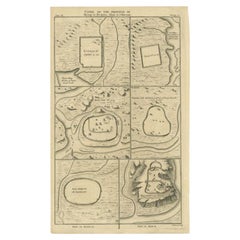
Antique Map of Cities in the Region of Hubei in China, 1758
Located in Langweer, NL
Hubei (/hu?'be?/;[6] Chinese: ??; alternately Hupeh) is a landlocked province of the People's Republic of China, and is part of the Central China region.
Paper

$3,740Sale Price|35% Off
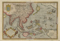
Antique Ortelius Map of Asia Featuring Japan, China, Taiwan & East Indies, 1587
By Abraham Ortelius
Located in Langweer, NL
Ortelius Asia Japan China Taiwan Philippines East Indies Antique Map 1570 This highly important early map of Asia titled “Indiae Orientalis Insularumque Adiacientium Typus” is one o...
Paper

$316Sale Price|20% Off
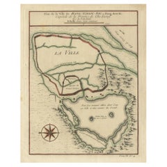
Antique Map of Hangzhou, Capital of the Province of Zheijang, China, 1748
Located in Langweer, NL
This original print shows a map of the city of Hangzhou, capital of the province of Zheijang, China.
Paper
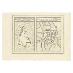

Antique Map of Cities of the Jiangsu Region in China, c.1760
By Jacques-Nicolas Bellin
Located in Langweer, NL
Antique map titled 'Plan de l' Enceinte de la Ville de Nan-King ou Kyang-Ning-Fou et plan de la ville de Su-Tcheou-Fou.' A map of the city of Nanking or Nanjing and a second map show...
Paper


Antique Map of Cities of the Province of Shanxi in China, 1749
By Jacques-Nicolas Bellin
Located in Langweer, NL
Antique print titled: 'Lan-Tcheou ou Lan-Chew dan la province Chensi; Can Tcheou ou Kan-Chew dan la province de Chensi; Tchin-Ywe-Fou ou Chin-Ywen-Fu dans la province de Koei-Tcheou ...
Paper
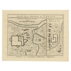

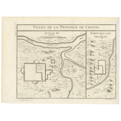
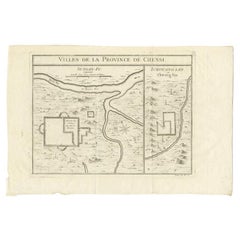
Antique Map of Cities in the Province of Shanxi in China, 1749
Located in Langweer, NL
Antique print titled 'Villes de la Province de Chensi - Steden van 't Landschap Shensi of Shansi'. Interesting set of two local town plans of ""Si-Ngan-Fu: Capitale."" and ""Tchang L...
Paper
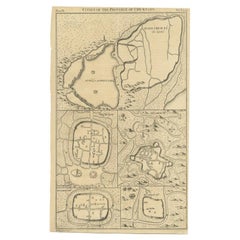

Antique Map of Cities of the Province of Che-Kyang in China, 1738
Located in Langweer, NL
Old map depicting four walled cities of the Chinese Qing dynasty province of Che-Kiang (modern day CHEKIANG): Hang Chew Fu (Hangchow) with the West Lake depicted, Ping-hu hyen, Hu-Ch...
Paper
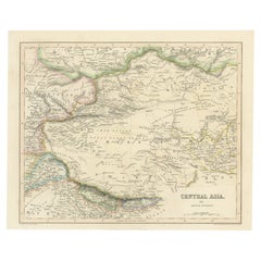

Steel Engraved Map of Central Asia Covering the Chinese Empire, Tibet Etc, C1843
Located in Langweer, NL
Steel engraved map of Central Asia covering the Chinese Empire, Tibet and surroundings.
Paper

Antique Map of Cities of the Province of Che-Kiang in China, 1738
Located in Langweer, NL
Old map depicting four walled cities of the Chinese Qing dynasty province of Che-Kiang (modern day CHEKIANG): Hang Chew Fu (Hangchow) with the West Lake depicted, Ping-hu hyen, Hu-Ch...
Paper
Antique Map of Tibet, The Gobi Desert and China by Bellin, circa 1764
Located in Langweer, NL
Old map of Tibet, Gobi desert and China depicting the Great Wall of China and caravan routes.
Paper

$325Sale Price|20% Off
Old Map of Tartary with Persia, Siberia, the Mogul Territories & China, ca.1717
Located in Langweer, NL
Old map depicting east of the Caspian Sea with parts of Persia, Siberia, the Mogul territories and on to western China.
Paper
$604Sale Price|20% Off
Decorative Map of the Empire of China, Korea, Japan, Taiwan, Lucon, Macau, 1780
Located in Langweer, NL
Decorative map of the Empire of China, depicting China, Corea ( Korea ), Japan, Tonquin and the Philippine island Lucon.
Paper
Map of Australia, New Zealand, Part of China, Japan and Southeast Asia, 1857
Located in Langweer, NL
German Antique map titled 'Australien'. Map of Australia, New Zealand, part of China, Japan and Southeast Asia.
Paper
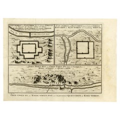

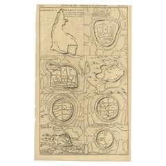
Antique Map of Three Chinese Cities in Chensi and Koei Tcheou, c.1758
Located in Langweer, NL
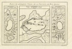
Three plans of old Chinese cities. While these maps by Van Schley after Bellin were initially made for 'Histoire Generale des Voyages' (Paris 1746-1759), this is from the 1758 Dutch ...
Paper


Antique Map of Cities in the Hubei and Hunan Provinces of China, 1755
By Jacques-Nicolas Bellin
Located in Langweer, NL
Depending on the individual map, presentation, and context, a rare or antique map can be modern, traditional, abstract, figurative, serious or whimsical.
Paper
1851 Tallis Map of China with Tibet, Formosa, and Burma – Engraved by J. Rapkin
Located in Langweer, NL
Title: 1851 Tallis Map of China with Tibet, Formosa, and Burma – Engraved by J.
Paper
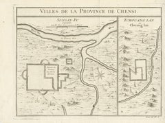
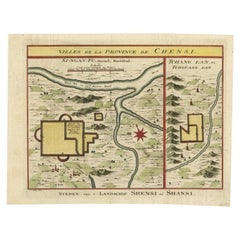
Antique Map of Si-Ngan-fu and Tchang Lan 'China' by Bellin '1748'
By Jacques-Nicolas Bellin
Located in Langweer, NL
Antique map China titled ‘Villes de la Province de Chensi’.
Paper

$316Sale Price|20% Off
Antique Map of Hangzhou, Capital of the Province of Zheijang, China, c.1750
Located in Langweer, NL
This original print shows a map of the city of Hangzhou, capital of the province of Zheijang, China.
Paper

$241Sale Price|20% Off
Antique Map of the Cities of the Qing Dynasty Provinces in China, 1738
Located in Langweer, NL
Antique print titled 'Cities of the Province of Kyang-si, Fo-kyen, Shan-Si & Yun-nan'. Old map depicting four walled cities of the Chinese Qing dynasty provinces Yunnan, Shanxi, Fuji...
Paper


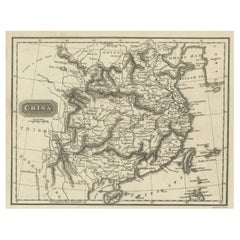
Antique Map of China, Also Depicting Formosa 'Taiwan' and Part of Korea, c.1840
Located in Langweer, NL
Antique map titled 'China'. Old map of China, also depicting Formosa (Taiwan) and part of Korea.
Paper
$502Sale Price|20% Off
Benedictus Goes’ Route – Antique Map of Tartary to China by Van der Aa, 1714
Located in Langweer, NL
Benedictus Goes’ Route – Antique Map of Tartary to China by Van der Aa, 1714 This fascinating antique map titled De Land-Reyse door Benedictus Goes, van Lahor gedaan, door Tartaryen...
Paper

Antique Map of China and Korea incl Formosa and Hainan, by Janssonius, ca.1650
Located in Langweer, NL
Antique map titled 'Imperii Sinarum Nova Descriptio'. Beautiful map of China and Korea, much detail troughout the map.
Paper

$642Sale Price|34% Off
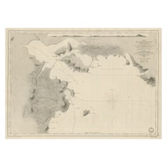
Antique Map of Part of the Chinese Coast, Explored by the French, Ca.1852
Located in Langweer, NL
Old map of part of the Chinese coast, explored with the French corvette 'Caprieuse'.
Paper

Antique Map of Two Cities in the Province of Shanxi or Chensi, China, 1748
By Jacques-Nicolas Bellin
Located in Langweer, NL
Antique map China titled ‘Villes de la Province de Chensi’.
Paper


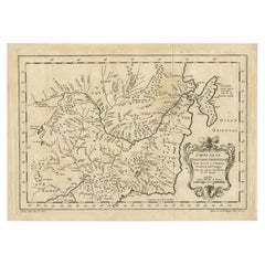
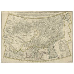
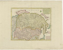
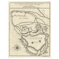
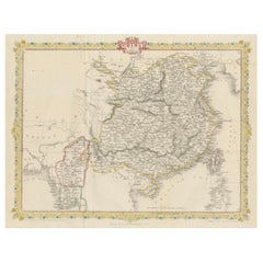
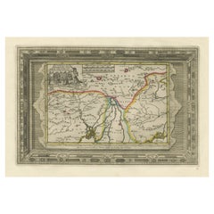
Antique Map of Northern China and Far Eastern Russia Around the Amur River, 1754
Located in Langweer, NL
A map for this far eastern portion of what is present day northern China and far eastern Russia.
Paper

Antique Hand-Coloured Map of Cities in the Province of Shanxi in China, 1749
Located in Langweer, NL
Antique print titled 'Villes de la Province de Chensi - Steden van 't Landschap Shensi of Shansi'. Interesting set of two local town plans of ""Si-Ngan-Fu: Capitale."" and ""Tchang L...
Paper
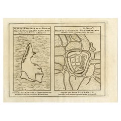

Antique Map of Cities Nanking and Suzhou in the Jiangsu Region, China, c.1758
Located in Langweer, NL
Antique map titled 'Plan de l' Enceinte de la Ville de Nan-King ou Kyang-Ning-Fou et plan de la ville de Su-Tcheou-Fou.' A map of the city of Nanking or Nanjing. A second map shows S...
Paper
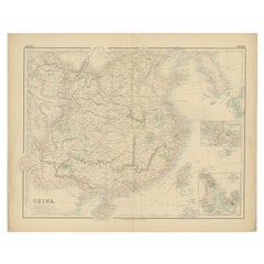

Antique Map of China with insets the Island of Chusan and Canton River, c.1860
Located in Langweer, NL
Antique map titled 'China'. Large map of China, with insets the Island of Chusan, and the Estuary of the Canton River from Hong Kong to Canton.
Paper

Antique Duval Map of East Asia with China, Japan, Korea and the Great Wall, 1663
Located in Langweer, NL
Duval Asia Map 1663 China Japan Korea Great Wall Antique French Cartography This elegant 17th-century map titled “L’Asie” is a finely executed French representation of the Asian con...
Paper
Antique Map of Three Cities of China's Hubei and Hunan Provinces by Bellin, 1755
By Jacques-Nicolas Bellin
Located in Langweer, NL
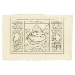
Antique print titled 'Plans de Quelques villes de la province de Hou-Quang.' Three bird's-eye view plans of walled cities in what are now China's Hubei (Hou-Quang) and Hunan Provin...
Paper


Antique Map of the Mouth of the Yangtze River 'China' by J.N. Bellin, 1764
Located in Langweer, NL
This detailed regional map of China is a historical cartographic work from the mid-18th century and is attributed to Antoine-François Prévost, a prominent French cartographer and geo...
Paper
Old Map of the Mainland of China and the Islands of Formosa or Taiwan, c.1817
Located in Langweer, NL
Antique map titled 'China'. Old map of the mainland of China and the islands of Formosa or Taiwan.
Paper
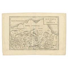

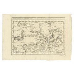
Antique Map of the Region Between the Caspian and the Sea of China by Toms, 1799
Located in Langweer, NL
Antique map titled 'Scythia et Serica'. Old map of the region between the Caspian and the Sea of China.
Paper

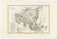
Antique Map of Asia by Dussy, 1778
Located in Langweer, NL
Depicting South-East Asia including Hindustan, India and China. This map originates from "Nouvel Atlas Portatif destine principalement sur l'Etude de la Geographie par le S.Robert Va...
Paper

$204Sale Price|20% Off
Antique Map of Southeast Asia by Dussy, 1778
Located in Langweer, NL
"Antique map titled 'Indostan presqu'isles de l'Inde, Chine, Tartarie Independante.' - A map of Asia: Hindustan, India and China.
Paper

$418Sale Price|20% Off
Antique Map of Southeast Asia by Van Dùren, 1752
Located in Langweer, NL
Antique map titled 'Neue Vorstellung von Indien und China'.
Paper

$353Sale Price|20% Off
Antique Map of the region of Siberia, Mongolia and Manchuria
Located in Langweer, NL
Antique map titled 'Siberia and Chinese Tartary'. Detailed antique map of the region of Siberia, Mongolia and Manchuria.
Paper


$390Sale Price|20% Off
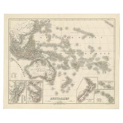
Mid-19th Century Map of Australasia by Carl Flemming - 1855
Located in Langweer, NL
Australia is centrally highlighted, with "AUSTRAL-LAND" boldly marked, showing the territories as they were known in the mid-19th century. The map's detail extends to the surrounding...
Paper
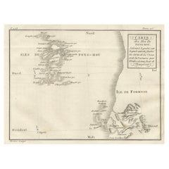
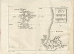
Map of Pescadores Islands (Pong-Hou) & Formosa – French Jesuit Engraving, 1790
Located in Langweer, NL
The map is titled in French as “Carte des Isles de Pong-Hou suivant le point sur lequel ont été faites les Cartes de la Chine et de la Tartarie par l’ordre et aux frais de l’Empereur...
Paper

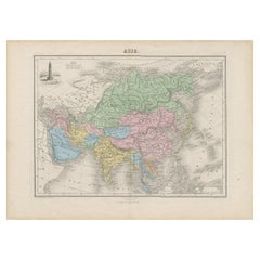
Antique Map of Asia with Intricate Provincial Boundaries, Published in 1903
Located in Langweer, NL
The map highlights key geographical features such as the Himalayas, the vast deserts of Central Asia, and the river systems of China and India.
Paper
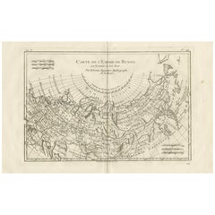
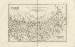
Russian Empire in Europe & Asia – Enlightenment Map by Rigobert Bonne, c.1780
Located in Langweer, NL
SEO keywords Russian Empire antique map, Russia antique map 18th century, Siberia antique map, Tartary antique map, Great Tartary map, Imperial Russia cartography, Enlightenment map ...
Paper
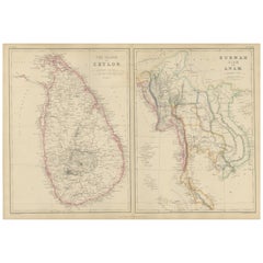
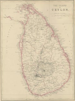
Ceylon, Burmah, Siam and Anam, Antique Map of South & Southeast Asia, 1860
Located in Langweer, NL
Blackie, Scotland, 1860 Keywords: Ceylon map, Sri Lanka map, Island of Ceylon, Colombo, Kandy, Galle, Trincomalee, Indian Ocean map, British Ceylon, plantation era, tea and spice tr...
Paper
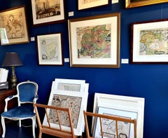
Antique and vintage collectibles and curiosities can bring whimsy and wonder to any interior.
Decorating with old scientific instruments, historical memorabilia and vintage musical instruments, as well as other authentic collectibles and curiosities that can be found on 1stDibs, presents an opportunity to create a unique, natural history museum-like atmosphere in your home that can provoke conversation as often as it pays tribute to how far we’ve come in understanding our world.
And bringing collectibles and curiosities into your space is actually on trend — Wunderkammern, or curiosity cabinets, were all the rage in Europe during the 1500s and continued to have adherents there and in the U.S. in the following centuries. Today, however, they’re experiencing a real surge in popularity and influencing how many interior designers are furnishing and decorating homes — combining contemporary with antique, scientific with tribal, earthly with extraterrestrial, Les Lalanne tables with Flemish tapestries.
The original Wunderkammern were entire rooms filled with objects demonstrating their owners’ worldly knowledge: A proper one included artificiala or preciosa (objets d’art); naturalia (such as skeletons, shells, minerals); exotica (taxidermy or dried plants); and scientifica (scientific instruments), frequently alongside religious relics and ancient artifacts.
Pay tribute to a history of rich and diverse musical traditions that have taken shape all over the world by decorating your home with a collection of antique and vintage musical instruments — with a little help from strong hanging wire or some wall hooks, vintage brass instruments such as a gong, French horn or trumpet can help elevate a home office or complement the efforts you’ve made to ensure a welcoming vibe in your home’s entryway. Bells or antique wind instruments can add provocative metallic contrasts to dark woods as tabletop decorative objects.
Create an intriguing focal point with Georgian scientific instruments, such as stick barometers with mahogany cases or lacquered brass telescopes. These items stem from an era named for the monarchies of the four King Georges, who ruled England in succession starting in 1714 (plus King William’s reign, which lasted until 1837). Just as there was beautiful jewelry produced during the period that today is coveted by collectors, there is much to be found in the collectibles and curiosities realm too.
Wanderlust, nostalgia and a shared love of good design are contributing factors to certain trends in decorating — just as vintage trunks and luggage have reappeared as furniture or home accents in a bedroom or foyer, decorating with globes, maps or nautical objects is similarly rooted in the allure of travel and a penchant for the stylish finishing touch that collectibles bring to our homes.
Find a wide range of antique and vintage collectibles and curiosities on 1stDibs.
It's hard to resist the allure of a beautiful pool. So, go ahead and daydream about whiling away your summer in paradise.
It’s never too early for good design. These interiors combine elevated furnishings and a youthful spirit, resulting in spaces that are at once elegant and whimsical.
Produced in 1843, the well-preserved volume is evidence of the author's exacting specifications.
New or old, the coverlets add old-time charm to any space.
Get into the games! These items celebrate the events, athletes, host countries and sporting spirit.
French trendsetter and serial collector Daniel Rozensztroch tells us about his obsession with objects related to seafaring men.
The sought-after designer worked with the team at Hoffman Creative to produce a monograph that beautifully showcases some of Studio Shamshiri's most inspiring projects.
Italian writer and collector Umberto Pasti opens the doors to his remarkable cave of wonders in North Africa.