Items Similar to Antique Map of the North Pole by V.M. Coronelli, circa 1692


Want more images or videos?
Request additional images or videos from the seller
1 of 6
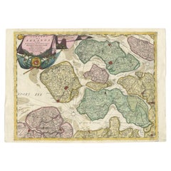
Antique Map of the North Pole by V.M. Coronelli, circa 1692
About the Item
Globe gore by Vincenzo Maria Coronelli shows the North Pole with the coasts of Canada, Greenland, Scandinavia and Siberia, and is decorated with pictorial scenes of bear, seal and whale hunters. The globe gore is based on the north part of Coronelli’s large terrestrial globe for Louis XIV.
- Creator:Vincenzo Coronelli (Artist)
- Dimensions:Height: 19.3 in (49 cm)Width: 26.78 in (68 cm)Depth: 0.02 in (0.5 mm)
- Materials and Techniques:
- Period:Late 17th Century
- Date of Manufacture:circa 1692
- Condition:Wear consistent with age and use. Minor fading. Please study images carefully.
- Seller Location:Langweer, NL
- Reference Number:Seller: BG-008741stDibs: LU305438972401
About the Seller
5.0
Platinum Seller
These expertly vetted sellers are 1stDibs' most experienced sellers and are rated highest by our customers.
Established in 2009
1stDibs seller since 2017
1,933 sales on 1stDibs
Typical response time: <1 hour
- ShippingRetrieving quote...Ships From: Langweer, Netherlands
- Return PolicyA return for this item may be initiated within 14 days of delivery.
Auctions on 1stDibs
Our timed auctions are an opportunity to bid on extraordinary design. We do not charge a Buyer's Premium and shipping is facilitated by 1stDibs and/or the seller. Plus, all auction purchases are covered by our comprehensive Buyer Protection. Learn More
More From This SellerView All
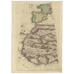
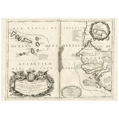
- Rare Antique Map of Southwestern Europe and West Africa by V.M. Coronelli, 1692By Vincenzo CoronelliLocated in Langweer, NLBeautiful hand-colored example of the Southwestern Europe and West Africa globe gore from Coronelli's 42 inch Terrestrial Globe. The globe gore embraces France, Iberia and all of Africa west of a line running from Algeria down to the Bight of Benin, as well as the Canary Islands and Madeira. One of the most accurate and finely engraved cartographic depictions of its era, the coastline of Africa appears in well-formed detail. The interior, which was an almost complete enigma, is adorned with mythical mountain ranges and exotic animals such as giraffes, elephants, lions and strange giant birds. The Gambia...Category
Antique Late 17th Century Maps
MaterialsPaper
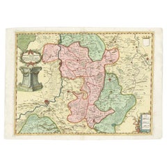
- Antique Map of the Province of Limburg by Coronelli, 1692Located in Langweer, NLAntique map titled 'Ducea di Limburgo (..)'. Beautiful map of the Dutch province of Limburg. Originates from 'Corso Geographico Universale'. Artists and Engravers: Published in Ven...Category
Antique 17th Century Maps
MaterialsPaper
- Antique Map of the Region of Liege by Coronelli, 1690By Vincenzo CoronelliLocated in Langweer, NLAntique map titled 'Vescovato di Liege (..)'. Map of the Belgium area centered on Liege and the course of Meuse/Maas River. Also depicts the cities of Maastricht, Namur and Tienen. O...Category
Antique 17th Century Maps
MaterialsPaper
- Antique Map of the Province of Zeeland, The Netherlands by Coronelli, 1692Located in Langweer, NLAntique map titled 'Contado di Zelanda'. Beautiful map of the Dutch province of Zeeland. With the islands of Walcheren, Schouwen-Duiveland, Noord-Beveland, Zuid-Beveland, Tholen and ...Category
Antique 17th Century Maps
MaterialsPaper
- Antique Map of Western Africa and the Cape Verde Islands by Coronelli, 1691By Vincenzo CoronelliLocated in Langweer, NLAntique map titled 'Bocche del Fiume Negro et Isole di Capo Verde'. Antique map of Western Africa with the Cape Verde Islands and an inset of Goree Island. Originates from 'Atlante V...Category
Antique Late 17th Century Italian Maps
MaterialsPaper
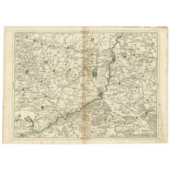
- Detailed Antique Map of Western Belgium and Eastern France by Coronelli, 1690By Vincenzo CoronelliLocated in Langweer, NLAntique map titled 'Contado d'Hannonia (..)'. Map of western Belgium and eastern France, from south of Brussels (not shown) to Cambrai, France, generally centered around the towns of...Category
Antique 17th Century Maps
MaterialsPaper

You May Also Like
- Large Antique 1859 Map of North AmericaLocated in Sag Harbor, NYThis Map was made by Augustus Mitchell in 1859 It is in amazing condition for being 163 years old. This price is for the rolled up easy to ship version of this piece. I will be Frami...Category
Antique Mid-19th Century American Maps
MaterialsCanvas, Paper

- New Map of North America from the Latest Discoveries, 1763Located in Philadelphia, PAA fine antique 18th century map of the North American seaboard. Entitled "A New Map of North America from the Latest Discoveries 1763". By the Cartographer/Engraver - John Spil...Category
Antique Mid-18th Century English Georgian Maps
MaterialsPaper
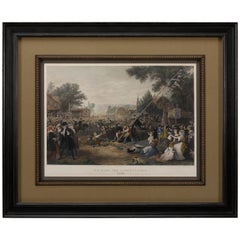
- "Raising the Liberty Pole" Hand-Colored Antique Print, 1875Located in Colorado Springs, COThis nineteenth-century engraving shows a liberty pole being raised in a town square in 1776, while a sign bearing the face of King George III is removed in the background. The rioto...Category
Antique 1870s American Historical Memorabilia
MaterialsPaper
- Map of the Republic of GenoaLocated in New York, NYFramed antique hand-coloured map of the Republic of Genoa including the duchies of Mantua, Modena, and Parma. Europe, late 18th century. Dimension: 25...Category
Antique Late 18th Century European Maps
- Antique Map of Italy by Andriveau-Goujon, 1843By Andriveau-GoujonLocated in New York, NYAntique Map of Italy by Andriveau-Goujon, 1843. Map of Italy in two parts by Andriveau-Goujon for the Library of Prince Carini at Palazzo Carini i...Category
Antique 1840s French Maps
MaterialsLinen, Paper
- Antique Map of Principality of MonacoBy Antonio Vallardi EditoreLocated in Alessandria, PiemonteST/619 - "Old Geographical Atlas of Italy - Topographic map of ex-Principality of Monaco" - ediz Vallardi - Milano - A somewhat special edition ---Category
Antique Late 19th Century Italian Other Prints
MaterialsPaper