Items Similar to 1690 Frederick de Wit Sea Chart of Hudson Bay, Baffin Bay and Greenland

Want more images or videos?
Request additional images or videos from the seller
1 of 6
1690 Frederick de Wit Sea Chart of Hudson Bay, Baffin Bay and Greenland
$1,603.80
£1,183.05
€1,340
CA$2,222.15
A$2,412.82
CHF 1,277.77
MX$29,574.30
NOK 15,812.86
SEK 14,942.32
DKK 10,201.23
About the Item
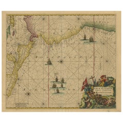
Title: c. 1690 Frederick de Wit Sea Chart of Hudson Bay, Baffin Bay, and Greenland - Engraved by Romeyn de Hooghe
This striking sea chart by Frederick de Wit, titled "Septemtrionaliora Americae à Groenlandia, per Freta Davidis et Hudson, ad Terram Novam," beautifully captures the coastlines of Hudson Bay, Baffin Bay, Davis Strait, and the surrounding parts of Canada and Greenland. Engraved by the talented Romeyn de Hooghe, this map was produced around 1690 and is based on earlier Arctic navigational maps from Jansson and Blaeu, along with information from Sanson's 1656 map. De Wit's chart was part of a significant series of Arctic maps that dominated navigation for the region throughout the late 17th century.
The map features vivid original coloring, decorative cartouches, and numerous rhumb lines that crisscross the chart, indicating the complexities of navigation in this remote part of the world. It includes depictions of ships, symbolic of maritime exploration, and a decorative title cartouche portraying explorers in a scene of adventure and discovery.
Frederick de Wit, originally from Gouda, was an influential Amsterdam-based mapmaker and publisher. His works were celebrated for their detail, accuracy, and aesthetic appeal. Following his death in 1706, much of his map collection was acquired by Pieter Mortier, whose firm eventually became part of Covens & Mortier, a significant player in 18th-century cartography.
This particular map is an excellent example of the intricate craftsmanship and geographic knowledge of the time, reflecting the rich history of exploration and the drive to chart the northernmost reaches of the American continent.
The map is in good condition, with several notable features:
- Paper Quality: The paper shows signs of age-related toning, particularly around the edges, consistent with its age. There are minor creases along the edges but no significant tears.
- Coloring: The original hand coloring remains vibrant, enhancing both the cartouches and geographical features. The colors have aged well, with minimal fading.
- Edges and Margins: The margins are intact, though there is some wear and toning along the edges. There are a few small edge tears, but they do not affect the map’s printed area.
- Folds and Creases: There are visible creases, particularly along the central fold, from the original binding. These creases are not heavily worn or significantly damaged.
- Cartouche and Details: The decorative cartouches are crisp, with clear detailing, and the rhumb lines across the map are still sharp and visible.
Summary: Overall, the map is in good condition for its age, with vibrant original coloring and clear engraving. Minor edge wear, creases, and toning are present but do not detract from the overall quality or displayability of the piece.
- Dimensions:Height: 21.07 in (53.5 cm)Width: 24.22 in (61.5 cm)Depth: 0.01 in (0.2 mm)
- Materials and Techniques:Paper,Engraved
- Period:1690-1699
- Date of Manufacture:1690
- Condition:Summary: Overall, the map is in good condition for its age, with vibrant original coloring and clear engraving. Minor edge wear, creases, and toning are present but do not detract from the overall quality or displayability of the piece.
- Seller Location:Langweer, NL
- Reference Number:Seller: BHZ113771stDibs: LU3054342590902
About the Seller
5.0
Recognized Seller
These prestigious sellers are industry leaders and represent the highest echelon for item quality and design.
Platinum Seller
Premium sellers with a 4.7+ rating and 24-hour response times
Established in 2009
1stDibs seller since 2017
2,622 sales on 1stDibs
Typical response time: <1 hour
- ShippingRetrieving quote...Shipping from: Langweer, Netherlands
- Return Policy
Authenticity Guarantee
In the unlikely event there’s an issue with an item’s authenticity, contact us within 1 year for a full refund. DetailsMoney-Back Guarantee
If your item is not as described, is damaged in transit, or does not arrive, contact us within 7 days for a full refund. Details24-Hour Cancellation
You have a 24-hour grace period in which to reconsider your purchase, with no questions asked.Vetted Professional Sellers
Our world-class sellers must adhere to strict standards for service and quality, maintaining the integrity of our listings.Price-Match Guarantee
If you find that a seller listed the same item for a lower price elsewhere, we’ll match it.Trusted Global Delivery
Our best-in-class carrier network provides specialized shipping options worldwide, including custom delivery.More From This Seller
View AllAntique Sea Chart of Hudson Bay and Arctic Canada by Van Keulen, circa 1681
Located in Langweer, NL
Antique map titled 'Pascaarte vande Noorderzee Custen van America (..)'. Sea chart of Hudson Bay and Arctic Canada. Compass roses, loxodromic lines, and ships decorate the oceans and...
Category
Antique Late 17th Century Maps
Materials
Paper
Rare North Atlantic and Caribbean Sea Chart: Newfoundland to Venezuela, 1745
Located in Langweer, NL
This impressive map titled "Terra Neuf, en de Custen van Nieu Vranckryck, Nieuw Engeland... Venezuela," published by Louis Renard in 1745, captures the North Atlantic coastline, enco...
Category
Antique 1740s Maps
Materials
Paper
1717 Johannes Van Keulen Sea Chart of the Eastern Atlantic - Amsterdam to Gambia
Located in Langweer, NL
1717 Johannes Van Keulen Sea Chart of the Eastern Atlantic - Amsterdam to Gambia
This 1717 sea chart by Johannes Van Keulen, titled "Nieuwe Paskaert vande ...
Category
Antique 1710s Maps
Materials
Paper
Antique Sea Chart of North America by Ottens, circa 1745
Located in Langweer, NL
Antique map titled 'Septemtrionaliora Americae a Groenlandia (..)'. Sea chart of the northern waters of North America, including the coast of Labrador and pa...
Category
Antique Mid-18th Century Maps
Materials
Paper

Sea Chart of Central America and the Northwest Coast of South America, ca.1745
Located in Langweer, NL
Antique map titled 'Novae Hispaniae, Chili, Peruviae et Guatamala Littorae.'
Sea chart of Central America and the northwest coast of South America, oriented to the east, by Reinier & Joshua Ottens (after Frederick de Wit - 1675) in 1745 ('Atlas van de Zeevaart'). The map shows all or parts of the coasts of Peru, Chili, Honduras, Costa Rica and Mexico as well as the western Caribbean and the Galapagos...
Category
Antique 1740s Maps
Materials
Paper
$2,345 Sale Price
20% Off
Free Shipping
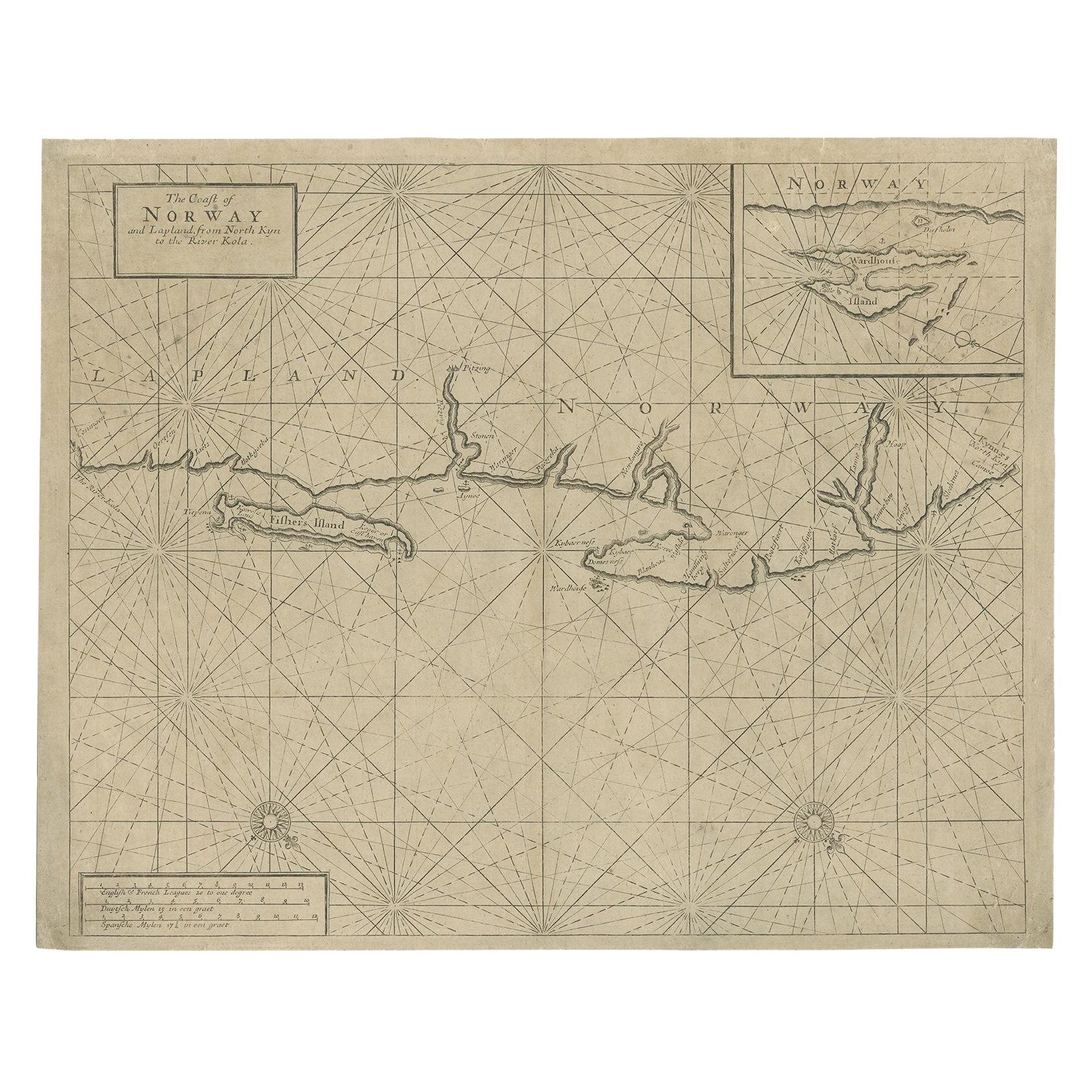
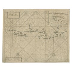
Old Sea Chart of Northern Norway, also depicting Part of Lapland & Russia, 1702
Located in Langweer, NL
Antique map titled 'The Coast of Norway and Lapland, from North kyn to the River Kola'.
Sea Chart of Northern Norway, also depicting part of Lapland and Russia. The map covers from the Kola river to what the map calls Fishers Island...
Category
Antique Early 1700s Maps
Materials
Paper
$469 Sale Price
20% Off
You May Also Like
Ancient Map-Poli Arctici (Map of the Poles)-Etching by Johannes Janssonius-1650s
By Johannes Janssonius
Located in Roma, IT
Poli Arctici is an ancient map realized in 1650 by Johannes Janssonius (1588-1664).
The Map is a Hand-colored etching, with coeval watercoloring.
Good conditions with slight foxing...
Category
1650s Modern Figurative Prints
Materials
Etching

Rugen Island, Germany: An Early 17th Century Map by Mercator and Hondius
By Gerard Mercator
Located in Alamo, CA
This is an early 17th century map entitled "Nova Famigerabilis Insulae Ac Ducatus Rugiae Desciptio" (Map of Rugen Island, Germany) by Gerard Mercator and Henricus and Joducus Hondiu...
Category
Early 17th Century Old Masters Landscape Prints
Materials
Engraving

California: 18th Century Hand-colored Map by de Vaugondy
By Didier Robert de Vaugondy
Located in Alamo, CA
This is an 18th century hand-colored map of the western portions of North America entitled "Carte de la Californie et des Pays Nord-Ouest separés de l'Asie par le détroit d'Anian, ex...
Category
1770s Landscape Prints
Materials
Engraving

Antique Map - Mare Pacificum - Etching by Johannes Janssonius - 1650s
By Johannes Janssonius
Located in Roma, IT
Mare Pacificum is an antique map realized in 1650 by Johannes Janssonius (1588-1664).
The Map is Hand-colored etching, with coeval watercolorang.
Good conditions with slight foxing...
Category
1650s Modern Figurative Prints
Materials
Etching

Northwest Coast and Isle of Man Map
Located in Cheshire, GB
Greenville Collins Northwest Coast and Isle of Man. hand coloured chart, encased in an ebonised frame.
Dimensions
Height 26.5 Inches
Width 30 Inches
Depth 1 Inches
Category
Early 20th Century British Maps
Materials
Paper

$525 Sale Price
20% Off
Siberia as Explored by Behring: Original 18th Century Hand-colored Map by Bowen
Located in Alamo, CA
This is an original 18th century hand-colored map entitled "An Exact Chart of all the Countries through which Capt. Behring Travelled from Tobolski, Capital of Siberia to the Country...
Category
Mid-18th Century Old Masters Landscape Prints
Materials
Engraving

More Ways To Browse
Frederick Antique Furniture
Antique Hudson Bay
18th Century Wood Side Tables
Antique Hand Carved Dining Room Sets
Mid Century Modern Pitcher
Vintage Italian Leather Dining Chair
Vintage Movie Posters
Blue Green Wool And Silk Rug
Brown Sheepskin Chair
Vintage Brass Bar Carts
Antique Botanical Prints
Green Persian Rug
17th Century Blue And White
50 X 50 Coffee Table
Antique Wood Panel Painted
Milo Baughman 1970
Spanish Baroque Furniture
Stone China