1 of 9
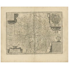
17th Century Hand-Colored Map of a Region in West Germany by Janssonius
$1,275List Price
About the Item
- Creator:Johannes Janssonius (Artist)
- Dimensions:Height: 27.5 in (69.85 cm)Width: 30 in (76.2 cm)Depth: 0.13 in (3.31 mm)
- Materials and Techniques:Paper,Engraved
- Place of Origin:
- Period:Mid-17th Century
- Date of Manufacture:1640
- Condition:Wear consistent with age and use.
- Seller Location:Alamo, CA
- Reference Number:Seller: # 16131stDibs: LU5206220491362
Authenticity Guarantee
In the unlikely event there’s an issue with an item’s authenticity, contact us within 1 year for a full refund. DetailsMoney-Back Guarantee
If your item is not as described, is damaged in transit, or does not arrive, contact us within 7 days for a full refund. Details24-Hour Cancellation
You have a 24-hour grace period in which to reconsider your purchase, with no questions asked.Vetted Professional Sellers
Our world-class sellers must adhere to strict standards for service and quality, maintaining the integrity of our listings.Price-Match Guarantee
If you find that a seller listed the same item for a lower price elsewhere, we’ll match it.Trusted Global Delivery
Our best-in-class carrier network provides specialized shipping options worldwide, including custom delivery.You May Also Like
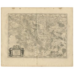
Antique Map of the Maine Region by Janssonius, 1657
By Johannes Janssonius
Located in Langweer, NL
Antique map of France titled 'Diocese du Mans vulgo le Mains'. Decorative map of the region of Maine, France. This map originates from 'Atlas Novus, Sive Theatrum Orbis Orbis Terraru...
Category
Antique 17th Century Maps
Materials
Paper

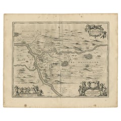
Antique Map of the Region of Picardy by Janssonius, 1657
By Johannes Janssonius
Located in Langweer, NL
Antique map of France titled 'Picardia vera et inferior'. Detailed map of the Picardy region of France. This map originates from 'Atlas Novus, Sive Theatrum Orbis Orbis Terrarum: In ...
Category
Antique Mid-17th Century Maps
Materials
Paper

$479 Sale Price
20% Off
H 19.69 in W 23.63 in D 0.02 in
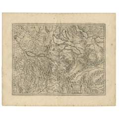
Antique Map of the Region of Lyonnais by Janssonius, '1657'
By Johannes Janssonius
Located in Langweer, NL
Antique map 'Lionnois, forest, beauviolois et masconnois'. Decorative map of the Lyonnais region, France. The Lyonnais is a historical province of France which owes its name to the c...
Category
Antique Mid-17th Century Maps
Materials
Paper

$479 Sale Price
20% Off
H 19.69 in W 23.63 in D 0.02 in
Antique Map of the Region of Limoge by Janssonius, '1657'
By Johannes Janssonius
Located in Langweer, NL
Antique map 'Totius Lemovici et consinium provinciaru quantum ad dioecesin Lemovicensen spectant'. Decorative map of the province of Limoge based on the important map of Antoin-Jean ...
Category
Antique Mid-17th Century Maps
Materials
Paper
$575 Sale Price
20% Off
H 19.69 in W 23.63 in D 0.02 in
Antique Map of the Region of Saintonge by Janssonius, 1657
By Johannes Janssonius
Located in Langweer, NL
Antique map 'La Saintonge vers le Midy avecq le Brovageais'. Decorative map of the Saintonge region, a former province of France located on the west central Atlantic coast. This map ...
Category
Antique Mid-17th Century Maps
Materials
Paper

$575 Sale Price
20% Off
H 19.69 in W 23.63 in D 0.02 in
Antique Map of the Region of Charolais by Janssonius, 1657
By Johannes Janssonius
Located in Langweer, NL
Antique map 'Les environs de L'Estang de Longpendu, comprenant une grande partie du Comté de Charolois'. Decorative map of the Charolais region. This map originates from 'Atlas Novus...
Category
Antique Mid-17th Century Maps
Materials
Paper
$503 Sale Price
20% Off
H 19.69 in W 23.63 in D 0.02 in
Antique Map of the Region of Aiguillon by Janssonius, 1657
By Johannes Janssonius
Located in Langweer, NL
Antique map 'Le Duche d'Aiguillon'. Decorative map of the Aiguillon region, France. Located at the confluence of the Lot and Garonne rivers. The map is based on the cartography of Pi...
Category
Antique Mid-17th Century Maps
Materials
Paper
$527 Sale Price
20% Off
H 19.69 in W 23.63 in D 0.02 in
Antique Map of the Region of Aargau by Janssonius, '1657'
By Johannes Janssonius
Located in Langweer, NL
Antique map 'Argow cum parte merid. Zurichgow'. Detailed map of Switzerland showing Aargau with the southern part of Zürich. This map originates from 'Atlas Novus, Sive Theatrum Orbi...
Category
Antique Mid-17th Century Maps
Materials
Paper
$575 Sale Price
20% Off
H 14.97 in W 19.69 in D 0.02 in
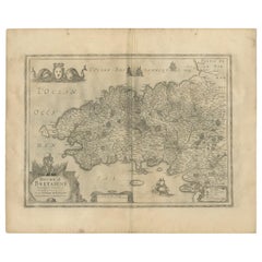
Antique Map of the Region of Bretagne by Janssonius '1657'
By Johannes Janssonius
Located in Langweer, NL
Antique map 'Duche de Bretaigne'. Detailed map of Bretagne, France. With decorative cartouches for the title, key and scale, a large armorial and several vignette galleons. This map ...
Category
Antique Mid-17th Century Maps
Materials
Paper
$575 Sale Price
20% Off
H 14.97 in W 19.69 in D 0.02 in
Antique Map of the Region of Rethelois by Janssonius, 1657
By Johannes Janssonius
Located in Langweer, NL
Antique map of France titled 'Dioecese de Rheims et le Païs de Rethel'. Detailed map, centered on the River Ayne and the River Velle and sowing Reims, Chalons, Sedan, Charleville, as...
Category
Antique Mid-17th Century Maps
Materials
Paper

$474 Sale Price
20% Off
H 19.69 in W 23.63 in D 0.02 in
Recently Viewed
View AllMore Ways To Browse
Mercator Map
Antique Maps Australia
Used Nautical Charts
Antique Collectables Australia
Joan Blaeu
Map Greece
Antique Maps Of New York City
Map Railroad
Antique Railroad Maps
Pirate Antique
Antique Maps Of Greece
Brazilian Antiques
Turkey Map
Map Of Japan
Antique Nautical Charts
Denmark Map
Antique Macedonia
Hemispheres Map