Items Similar to 18th-Century Map of the Swiss Confederation by Robert de Vaugondy


Want more images or videos?
Request additional images or videos from the seller
1 of 10
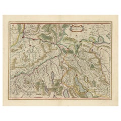
18th-Century Map of the Swiss Confederation by Robert de Vaugondy
$951.19
£707
€799
CA$1,313.34
A$1,456.40
CHF 765.23
MX$17,794.68
NOK 9,574.04
SEK 8,986.88
DKK 6,083.99
About the Item
Title: 18th-Century Map of the Swiss Confederation by Robert de Vaugondy
Description: This detailed 18th-century map by Gilles Robert de Vaugondy presents the Swiss Confederation, including its 13 cantons, allied territories, and subject lands during the Old Swiss Confederacy period.
The map provides a comprehensive view of the political landscape before the Napoleonic Wars, with cantonal borders highlighted in hand-coloring. Major cities such as Zurich, Bern, Geneva, and Lucerne are clearly marked, alongside significant Alpine passes, lakes, and rivers that played a crucial role in trade and military strategy.
The elaborate cartouche, adorned with Swiss heraldic symbols and military paraphernalia, reflects the confederation’s independence and martial history. The map also includes a legend explaining the alliances of the Swiss cantons with neighboring regions such as the Duchy of Savoy and the Holy Roman Empire.
Condition: The map is in very good condition, with sharp engraving and well-preserved hand-coloring. There is a visible centerfold, typical of antique maps, with minor creases and slight toning along the margins. No significant tears or stains, making this a highly collectible and display-worthy piece.
Framing tips: A classic wood or gilded frame enhances the historical charm of this map. Use acid-free matting and UV-resistant glass to protect against light exposure and aging. A double-matting approach, with a neutral inner border, can help emphasize the detailed cartography. Consider museum-grade framing to ensure long-term preservation.
- Dimensions:Height: 20.08 in (51 cm)Width: 25.6 in (65 cm)Depth: 0.01 in (0.2 mm)
- Materials and Techniques:Paper,Engraved
- Period:1750-1759
- Date of Manufacture:1756
- Condition:Condition: The map is in good condition, with sharp engraving and well-preserved hand-coloring. There is a visible centerfold, typical of antique maps, with minor creases and slight toning along the margins. No significant tears or stains.
- Seller Location:Langweer, NL
- Reference Number:Seller: BG-13668-11stDibs: LU3054343868422
About the Seller
5.0
Recognized Seller
These prestigious sellers are industry leaders and represent the highest echelon for item quality and design.
Platinum Seller
Premium sellers with a 4.7+ rating and 24-hour response times
Established in 2009
1stDibs seller since 2017
2,609 sales on 1stDibs
Typical response time: <1 hour
- ShippingRetrieving quote...Shipping from: Langweer, Netherlands
- Return Policy
Authenticity Guarantee
In the unlikely event there’s an issue with an item’s authenticity, contact us within 1 year for a full refund. DetailsMoney-Back Guarantee
If your item is not as described, is damaged in transit, or does not arrive, contact us within 7 days for a full refund. Details24-Hour Cancellation
You have a 24-hour grace period in which to reconsider your purchase, with no questions asked.Vetted Professional Sellers
Our world-class sellers must adhere to strict standards for service and quality, maintaining the integrity of our listings.Price-Match Guarantee
If you find that a seller listed the same item for a lower price elsewhere, we’ll match it.Trusted Global Delivery
Our best-in-class carrier network provides specialized shipping options worldwide, including custom delivery.More From This Seller
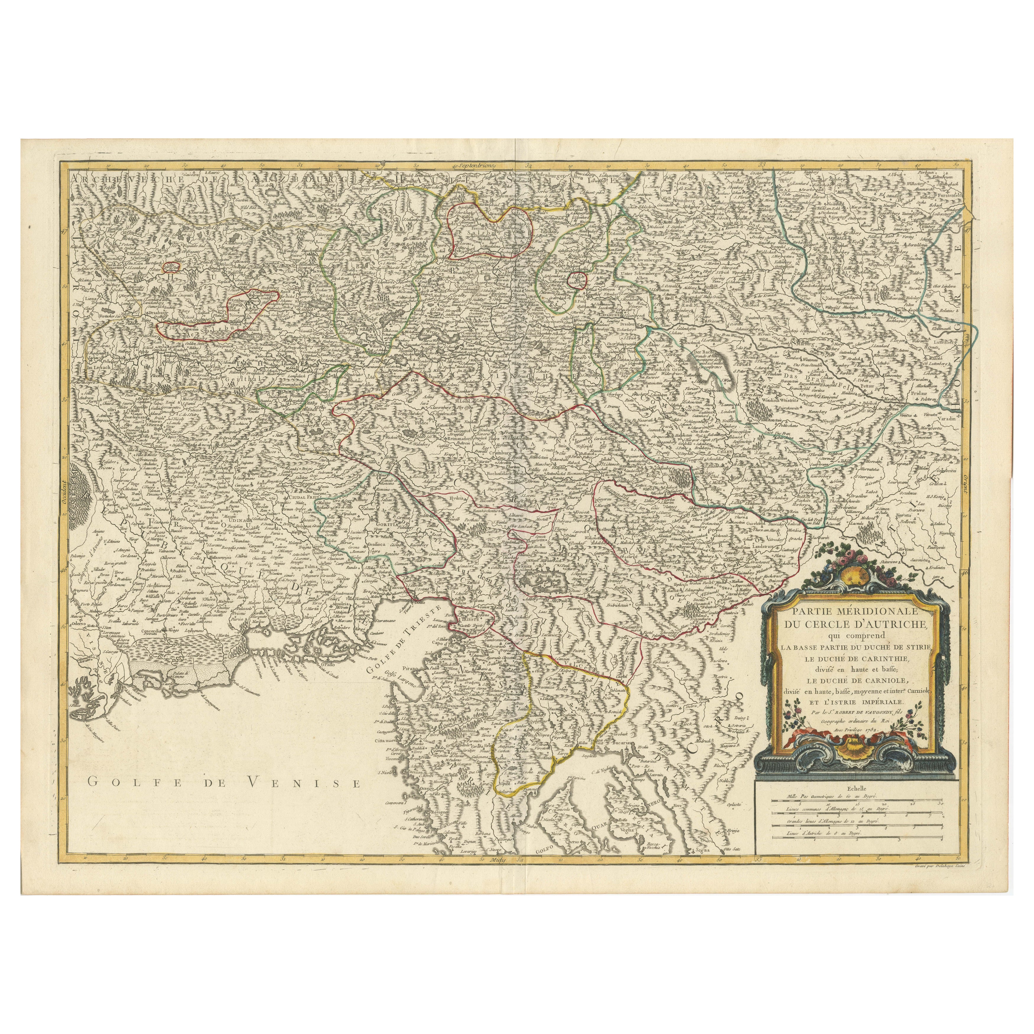
View AllOriginal 18th-Century Map of Southern Austria, Carinthia, Carniola, and Styria
Located in Langweer, NL
title: 18th-Century Map of Southern Austria, Carinthia, Carniola, and Styria by Robert de Vaugondy
Description: This finely engraved 18th-century map by Gilles Robert de Vaugondy ...
Category
Antique 1750s French Maps
Materials
Paper

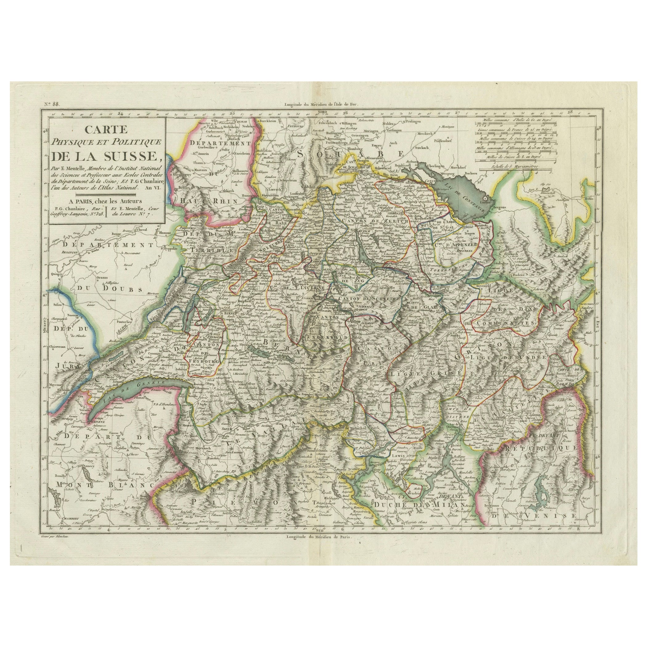
Physical & Political Map of Switzerland: Late 18th Century - Mentelle Atlas
Located in Langweer, NL
Antique Map with Title: 'Carte Physique et Politique de la Suisse'
**Publication Details:**
- **Atlas Title:** Nouvel Atlas Universel de Géographie Ancienne et Moderne
- **Purpose:...
Category
Antique 1790s Maps
Materials
Paper

$504 Sale Price
20% Off
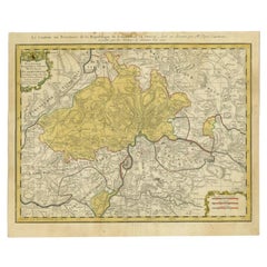
Original Hand-Colored Antique Regional Map of Switzerland, 1753
Located in Langweer, NL
Antique map Switzerland titled 'Territorium Reipublicae liberae Helveticae Scaphusiensis (..)'. Regional map of Switzerland.
Artists and En...
Category
Antique 1750s Maps
Materials
Paper
$561 Sale Price
20% Off
Map of Northwestern Switzerland (Basel and Zurich Region) by Willem & Jan Blaeu
Located in Langweer, NL
Map of Northwestern Switzerland by Willem & Jan Blaeu (Circa 1650)
This is a detailed map of Northwestern Switzerland, specifically depicting the region between Basel and Zurich, cr...
Category
Antique 1650s Maps
Materials
Paper
$904 Sale Price
30% Off
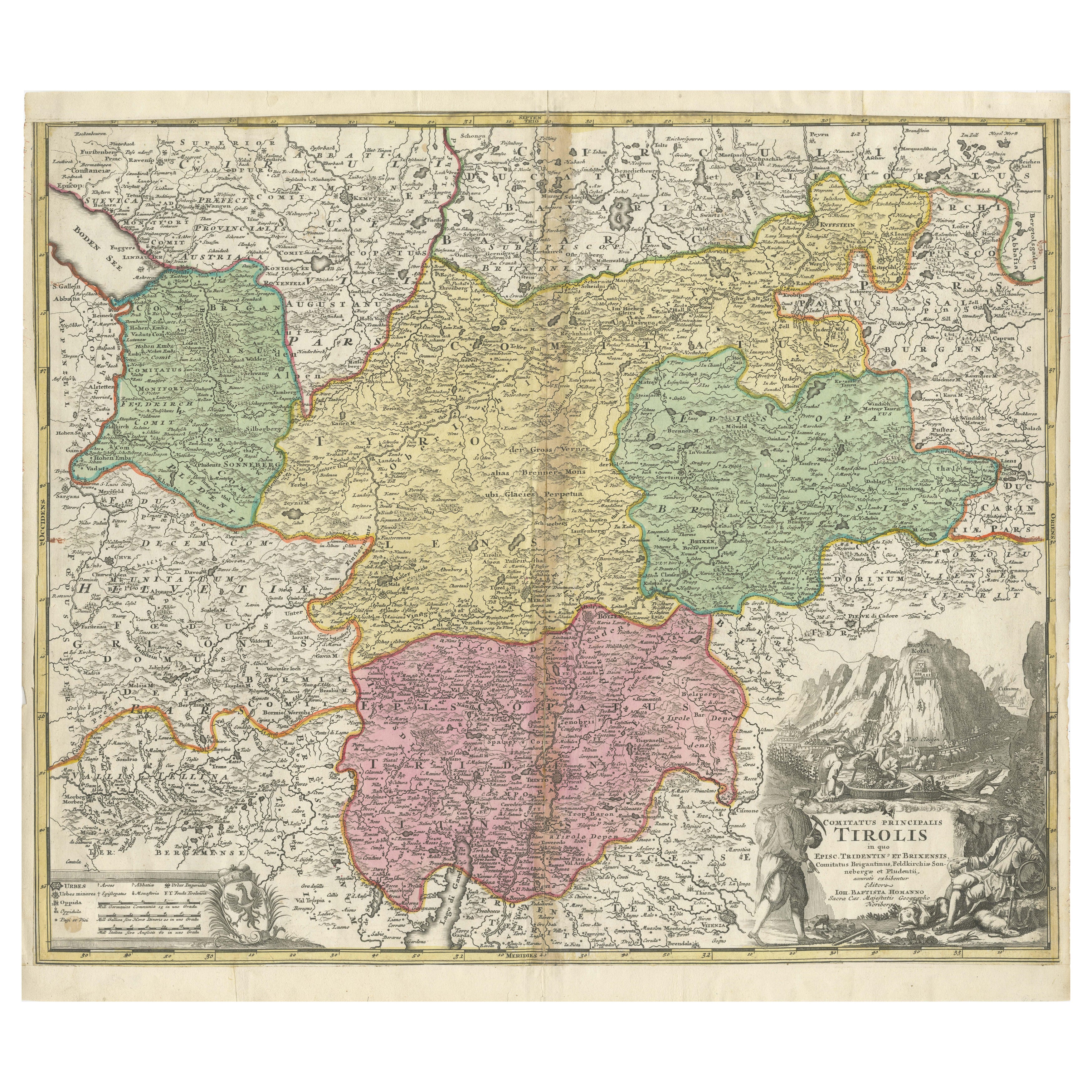
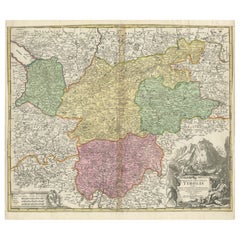
18th-Century Map of Tyrol and Surrounding Regions by Johann Baptist Homann
Located in Langweer, NL
18th-Century Map of Tyrol and Surrounding Regions by Johann Baptist Homann
Description: This striking 18th-century map by Johann Baptist Homann depicts the County of Tyrol (Tirol)...
Category
Antique 1720s Maps
Materials
Paper
Antique Map of Switzerland by Homann, 1753
Located in Langweer, NL
Antique map Switzerland titled 'Territorium Reipublicae liberae Helveticae Scaphusiensis (..)'. Regional map of Switzerland. Artists and Engrav...
Category
Antique 18th Century Maps
Materials
Paper
$283 Sale Price
20% Off
You May Also Like
Original Antique Map of Switzerland, Engraved By Barlow, Dated 1807
Located in St Annes, Lancashire
Great map of Switzerland
Copper-plate engraving by Barlow
Published by Brightly & Kinnersly, Bungay, Suffolk.
Dated 1807
Unframed.
Category
Antique Early 1800s English Maps
Materials
Paper

1752 Vaugoundy Map of Flanders : Belgium, France, and the Netherlands, Ric.a002
Located in Norton, MA
Large Vaugoundy Map of Flanders:
Belgium, France, and the Netherlands
Colored -1752
Ric.a002
Description: This is a 1752 Didier Robert de Vaugondy map of Flanders. The map de...
Category
Antique 17th Century Unknown Maps
Materials
Paper

1656 Jansson Map Metz Region of France Entitled "Territorium Metense" Ric0014
Located in Norton, MA
1656 Jansson map Metz Region of France entitled "Territorium Metense."
Ric0014
" Authentic" - Map of the historical region surrounding Metz, in Lorraine, France.
Oriented with ...
Category
Antique 17th Century Dutch Maps
Materials
Paper

17th Century Nicolas Visscher Map of Southeastern Europe
Located in Hamilton, Ontario
A beautiful, highly detailed map of southeastern Europe by Nicolas Visscher. Includes regions of Northern Italy (showing the cities Bologna, Padua, and Venice), Bohemia, Austria (sho...
Category
Antique 17th Century Dutch Maps
Materials
Paper

$1,350 Sale Price
38% Off
Antique Colored Belgium Map Flandria Gallica Flanders Henricus Hondius
Located in Dayton, OH
Antique hand colored map of Flanders, Belgium, engraved by Henricus Hondius.
Sans frame - 21.25” x 18”.
Category
Antique 19th Century Renaissance Maps
Materials
Paper

$262 Sale Price
25% Off
1640 Joan Bleau Map Entitled"Diocecese de rheims et le pais de rethel, " Eic.a011
Located in Norton, MA
1640 Joan Bleau map entitled
"Diocecese de rheims et le pais de rethel,"
Ric.a011
OAN BLAEU
Diocecese de Rheims, et le pais de Rethel.
Handcolored engraving, c.1640.
...
Category
Antique 17th Century Dutch Maps
Materials
Paper

More Ways To Browse
Napoleonic Wars
Swiss Alpine Furniture
Old Canton
Vintage Scandanavian Chairs
19th Century Red Glass
Antique French Console Table Tables
Silver Bowl Large
Antique French Silk
Down Couch
Used Lighter Art
Blue Edge Glass
Mahogany 1950s Furniture
Solid Mahogany Table
Dessert Glasses
Geometric Glass Table
Mid Century Pin
6x10 Rug
Studded Furniture