Items Similar to 1939 "A Good-Natured Map of the United States" by Greyhound


Want more images or videos?
Request additional images or videos from the seller
1 of 11
1939 "A Good-Natured Map of the United States" by Greyhound
$1,250
£949.48
€1,094.12
CA$1,760.31
A$1,951.56
CHF 1,025.62
MX$23,883.94
NOK 12,808.99
SEK 12,022.51
DKK 8,166.92
About the Item
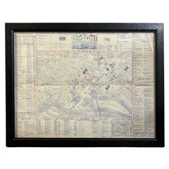
Presented is an original 1939 map, titled “A Good-Natured Map of the United States Setting Forth the Services of the Greyhound Lines and a Few Principal Connecting Bus Lines.” This brightly colored pictographic map was one of several similar United States maps issued by Greyhound in the 1930s and 1940s, during the heyday of bus transportation in the US.
The Greyhound bus routes are delineated in bold black lines with the interconnecting routes in bold dashed lines. In contrast, thin lines delineate state borders. Small pictographs scattered along and inside the map highlight the attractions throughout the country and along popular bus routes. Many of these pictographs are accompanied by light-hearted text or tongue-in-cheek puns, such as "Gosh! a mile up" in Denver, “Some Ditch” by the Grand Canyon, and in Nebraska, "no use making a pig of yourself, get out there an' give a lady a chance." Flanking the title cartouche at top are two vintage Greyhound buses. The map is further embellished with a fancy legend cartouche featuring the iconic greyhound silhouette, and a large compass rose in the Atlantic Ocean.
This full-color pictographic map is filled with charming vignettes and figures, and is a charming reminder of the printed advertising from that era. There is no artist attribution, besides a small monogram at lower right with a "K" followed by the delta symbol.
CONDITION:
Very good condition. Printed color is very vibrant, without fading. Paper is healthy and bright, with no marks or tears in the image. Map is artfully framed in a custom wood frame with UV glass.
Framed Dimensions: 22"H x 31 3/4"W x 5 /8"D.
Accompanied by our company's letter of authenticity.
- Dimensions:Height: 22 in (55.88 cm)Width: 31.75 in (80.65 cm)Depth: 0.63 in (1.61 cm)
- Style:Art Deco (Of the Period)
- Materials and Techniques:
- Place of Origin:
- Period:
- Date of Manufacture:1939
- Condition:Additions or alterations made to the original: Framed by Rio Grande in Colorado Springs, CO, in October of 2024. Wear consistent with age and use. Minor fading.
- Seller Location:Colorado Springs, CO
- Reference Number:Seller: M3691stDibs: LU909742692912
About the Seller
4.9
Vetted Professional Seller
Every seller passes strict standards for authenticity and reliability
Established in 2010
1stDibs seller since 2011
464 sales on 1stDibs
- ShippingRetrieving quote...Shipping from: Colorado Springs, CO
- Return Policy
Authenticity Guarantee
In the unlikely event there’s an issue with an item’s authenticity, contact us within 1 year for a full refund. DetailsMoney-Back Guarantee
If your item is not as described, is damaged in transit, or does not arrive, contact us within 7 days for a full refund. Details24-Hour Cancellation
You have a 24-hour grace period in which to reconsider your purchase, with no questions asked.Vetted Professional Sellers
Our world-class sellers must adhere to strict standards for service and quality, maintaining the integrity of our listings.Price-Match Guarantee
If you find that a seller listed the same item for a lower price elsewhere, we’ll match it.Trusted Global Delivery
Our best-in-class carrier network provides specialized shipping options worldwide, including custom delivery.More From This Seller
View All1960 "The 50 United States of America" Pictorial Map by Lorin Thompson
Located in Colorado Springs, CO
This colorful map of the United States was drawn by Lorin Thompson and published by the General Foods Corporation in 1960. The map was issued as a promotional pamphlet in advance of the 1960 presidential election. The cover title for the pamphlet reads: "Election Map and 1960 Presidential Fact Sheet...Yours Free with Any Purchase of Gravy Train."
The map has a unique pictorial style with bright colors and dynamic illustrations celebrating key moments of American history. The map is illustrated with past presidents, Native Americans, depictions of the "Golden Spike...
Category
Vintage 1960s Mid-Century Modern Prints
Materials
Paper
$1,750 Sale Price
22% Off
1943 "USO Map Guide to Washington"
Located in Colorado Springs, CO
This is a WWII map of Washington, DC, issued as a guide for service men and women visiting or working in the city during the war. The map was created by Allen F. Free and published a...
Category
Vintage 1940s American Mid-Century Modern Maps
Materials
Paper
1863 "Lloyd's New Map of the United States, the Canadas, and New Brunswick"
Located in Colorado Springs, CO
Presented is “Lloyd's New Map of the United States, the Canadas and New Brunswick, From the latest Surveys, Showing Every Railroad & Station Finished to June 1863, and the Atlantic and Gulf Coasts.” A large, Civil War-era hanging map of the United States and adjacent territories, this map covers the area from the Atlantic Ocean and extends as far west as the 103 meridian, to “Dacotah,” Nebraska, Kansas, "Indian Territory," and Texas. The southern continuation of Florida is shown in an inset map along the right margin. This map was published by J. T. Lloyd, in New York, in 1863. According to the publisher’s marking at lower right, this map was originally issued in two states: "in Sheets, Colored" for 50 cents, and "Varnished nicely, with Rollers" for $1.
Throughout the map, the counties are colored and the towns and cities well labeled. A reference key in the bottom margin provides symbols for railroads, turnpikes and wagon roads, state capitals, cities and towns, and village post offices. As emphasized in the map’s title, this map is especially notable for the countless railway lines and stations depicted, with distances noted between points, listing “every railroad and finished station to June 1863.” Additionally, two shipping agents and their routes are drawn out of New York City. The map includes details of the steamship routes into New York and Philadelphia from Liverpool and on to California and Oregon via an overland Nicaraguan trek, presumably to assist gold rush emigrants.
This expansive and impressive map depicts the eastern half of the United States in the third year of the Civil War. In order not to recognize the legitimacy of the Confederate States of America, each state is shown in the same manner as the Union states. The only indication that the American Civil War was in progress when this map was published is a printed notice that Gideon Wells, Secretary of the Navy, wishes to acquire a quote on 100 copies of Lloyd’s Mississippi River map...
Category
Antique 1860s American Maps
Materials
Linen, Wood, Paper

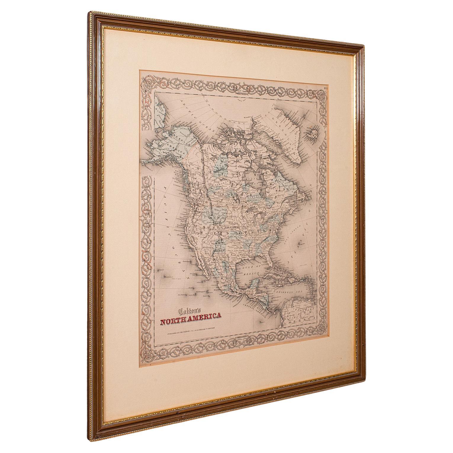
1859 "Map of the United States of America..." by J. H. Colton
By J.H. Colton
Located in Colorado Springs, CO
Presented is an 1859 “Map of the United States of America, the British Provinces, Mexico, the West Indies and Central America with Part of...
Category
Antique 1850s American Maps
Materials
Paper

1890 "Map of Oregon, Kansas, California, and the Territories" by S. A. Mitchell
By Samuel Augustus Mitchell 1
Located in Colorado Springs, CO
Presented is an 1890 map "Map of Oregon, Kansas, California, and the Territories" by S. A. Mitchell Jr. The map was issued in the atlas “Mitchell's New Intermediate Geography” publis...
Category
Antique 1890s American Victorian Maps
Materials
Paper

1846 "North America" Map, Engraved by I. Dower
Located in Colorado Springs, CO
Presented is an original 1846 map of “North America.” The map was drawn and engraved by I. Dower and published in London by Orr & Company. The map depicts North America, to include G...
Category
Antique 1840s English Victorian Maps
Materials
Paper

You May Also Like
Old Decorative Pictorial Map of the United States, circa 1953
Located in Langweer, NL
Antique map titled 'A Pictorial Map of the United States of America Showing Principal Regional Resources, Products, and Natural Features'.
This information-packed map was create by the General Drafting Company for the New Jersey Bell Telephone Company. The main map features over 700 drawings in full color including points of interest, natural resources, and agricultural products. At bottom are inset maps showing railroad lines, air routes, telephone lines, as well as a pictorial map of New Jersey...
Category
20th Century Maps
Materials
Paper

$713 Sale Price
20% Off
Vintage Framed United States Map
Located in Queens, NY
Vintage aged paper map of the United States mounted on particle board and framed in a simple wooden frame.
Category
20th Century American Mid-Century Modern Maps
Materials
Wood, Paper

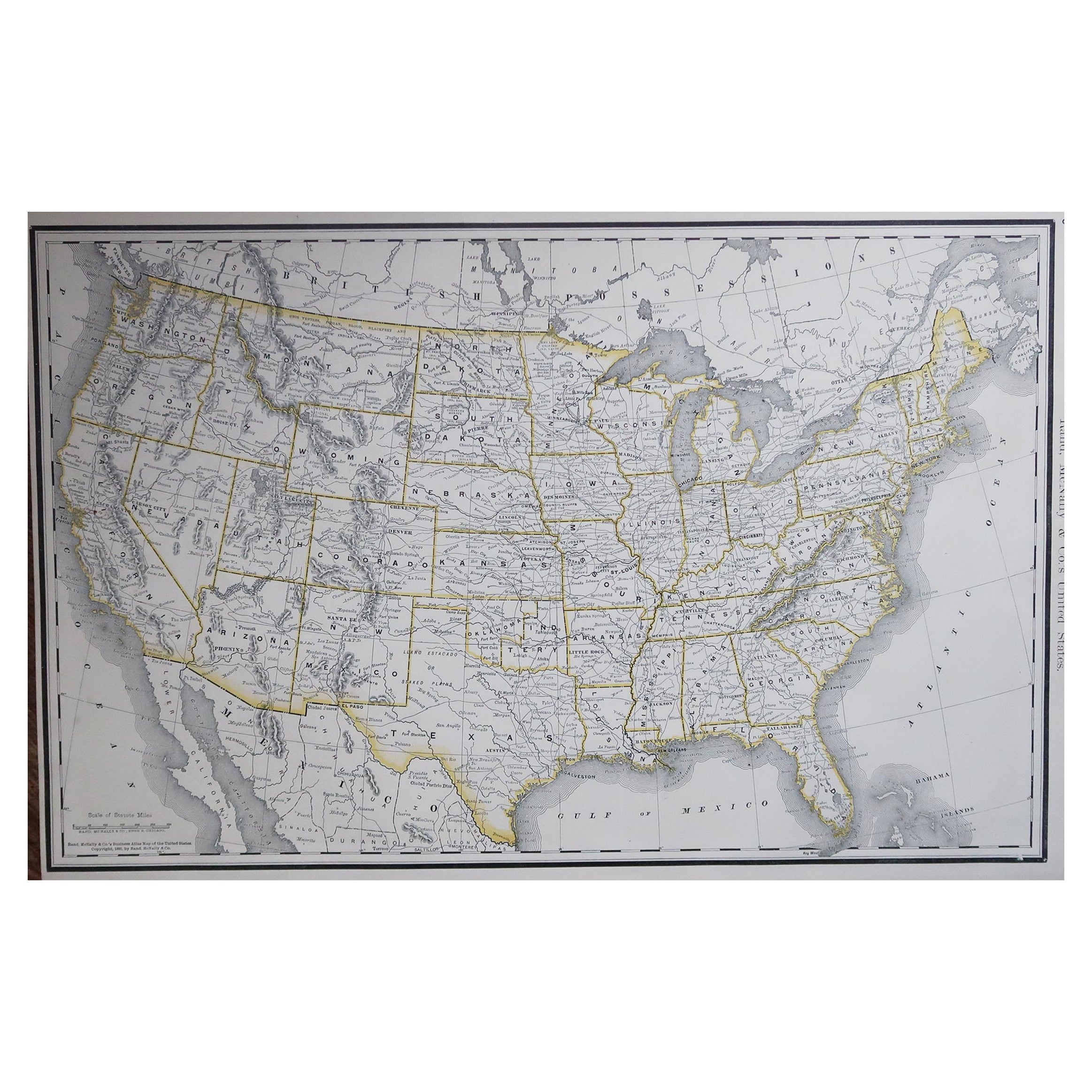
Large Original Antique Map of the United States of America. 1891
By Rand McNally & Co.
Located in St Annes, Lancashire
Fabulous map of The United States
Original color
By Rand, McNally & Co.
Dated 1891
Unframed
Free shipping.
Category
Antique 1890s American Maps
Materials
Paper

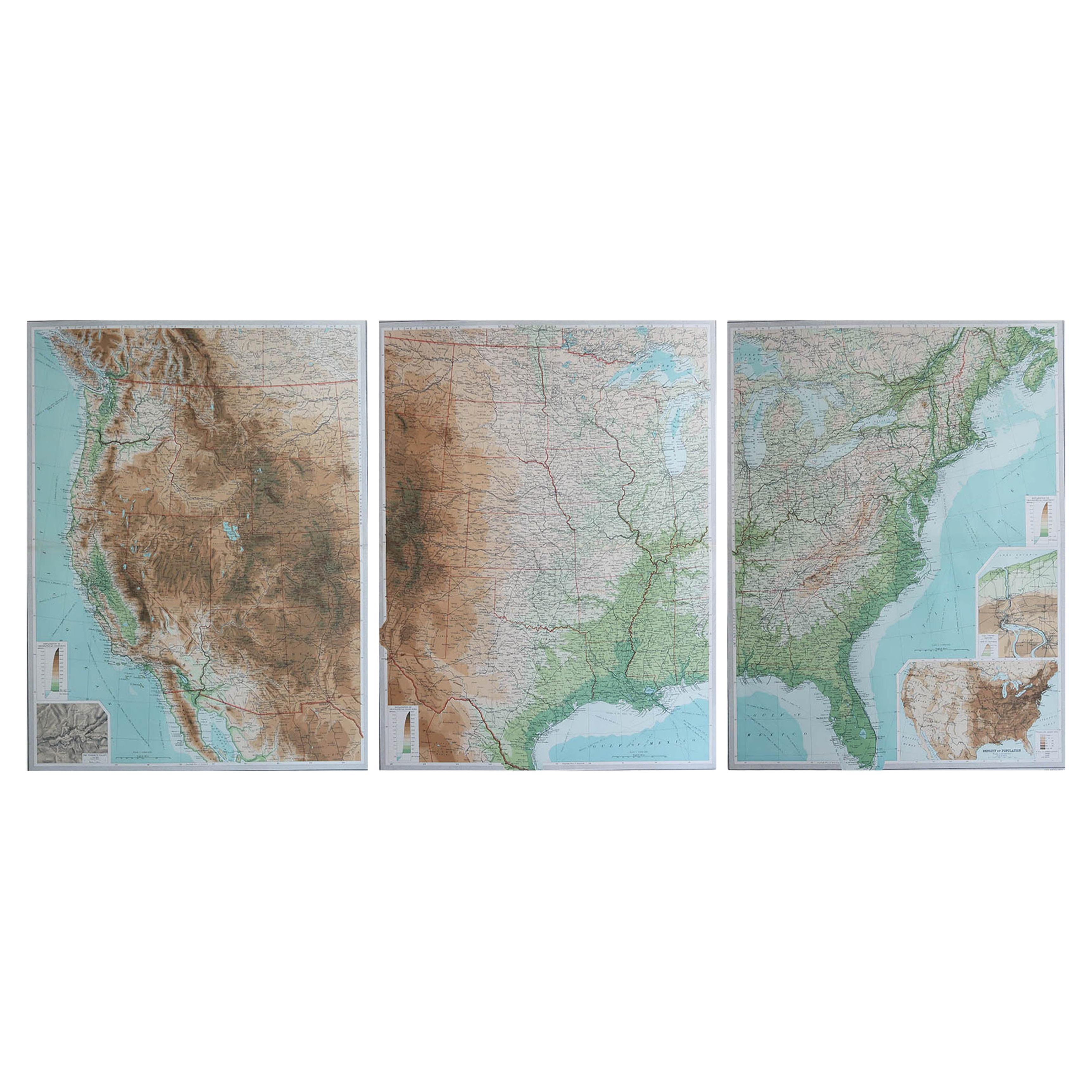
Large Vintage Maps of the United States, in 3 Sections, 1920
Located in St Annes, Lancashire
Great maps of the USA in 3 sections
Unframed
Original color
By John Bartholomew and Co. Edinburgh Geographical Institute
Published, circa 1920
The measurements given is for just...
Category
Vintage 1920s British Maps
Materials
Paper

Antique North America Map, USA, Canada, Mexico, Cartography, Colton, Victorian
Located in Hele, Devon, GB
This is an antique North America map. A USA, framed lithography atlas engraving of the continent by JH Colton, dating to the Victorian period and later, circa 1860.
Fascinating, large framed map...
Category
Antique Mid-19th Century American Victorian Maps
Materials
Paper

Antique Map of the United States ' North East ' by Johnston '1909'
Located in Langweer, NL
Antique map titled 'United States of North America'. Original antique map of United States of North America ( North East ). This map orig...
Category
Early 20th Century Maps
Materials
Paper

$237 Sale Price
20% Off
More Ways To Browse
The Vintage Map
Large Vintage Map
Glass Pig
Greyhound Glass
Vintage Letter K
Greyhound Bus
Red Retro Dining Set
Antique Silver Glasses Case
Carlo Scarpa 1934 Chairs
Christofle Marly
1900 Antique Chairs
Glass Table Italian Round
Mid Century Colonial
Alvar Aalto Poster
Geometric Metal Table
Post Modern High Chairs
United Nations
Vintage Vine Rug