Items Similar to A 19th-Century Map of West Canada with Niagara Falls and Indigenous Scenes


Want more images or videos?
Request additional images or videos from the seller
1 of 7
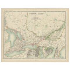
A 19th-Century Map of West Canada with Niagara Falls and Indigenous Scenes
$131.52
£97.36
€110
CA$181.99
A$200.64
CHF 104.97
MX$2,461.45
NOK 1,321.33
SEK 1,235.65
DKK 837.91
About the Item
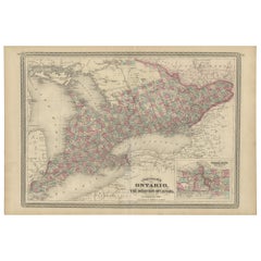
Decorative 19th-Century Map of West Canada with Niagara Falls and Indigenous Scenes
This detailed 19th-century map of West Canada, drawn and engraved by J. Rapkin and published by J & F Tallis, features finely hand-colored borders and intricate depictions of major settlements, roads, and waterways, including Lake Ontario and Lake Erie. The map highlights the regions of Southern Ontario during a period of significant development and growth.
Surrounding the map are stunning vignettes illustrated by H. Warren and engraved by J. H. Rogers. These include a scenic view of Niagara Falls, a depiction of Indigenous peoples in traditional settings, and other natural and cultural elements that add depth and historical context to the map. The decorative border enhances its artistic appeal, making it not only a practical geographical reference of its time but also a work of art.
Published in the mid-19th century, this map provides a fascinating glimpse into the geography and culture of West Canada during the Victorian era, making it a valuable addition for collectors of antique maps or those interested in Canadian history.
Year of Publication: Circa 1850s
Condition: Good with vibrant hand-colored bordelines, clear engravings, and minimal age-related wear, except for the folding line that is a bit rough and net yet flattened.
Keywords: West Canada, antique map, 19th-century map, decorative map, J. Rapkin, J & F Tallis, hand-colored map, Victorian cartography, engraved map, Niagara Falls, Lake Ontario, Lake Erie, Southern Ontario, Indigenous peoples, Canadian history, historical geography, cartographic art, H. Warren, J. H. Rogers, vintage Canada map, illustrated cartography, Canadian landmarks, Victorian-era Canada, Ontario settlements, cultural vignettes, exploration and discovery, decorative border, antique Canadian prints, early Canada maps.
- Dimensions:Height: 10.95 in (27.8 cm)Width: 14.26 in (36.2 cm)Depth: 0.01 in (0.2 mm)
- Materials and Techniques:Paper,Engraved
- Period:
- Date of Manufacture:circa 1850
- Condition:Condition: Good with vibrant hand-colored bordelines, clear engravings, and minimal age-related wear, except for the folding line that is a bit rough with tiny holes from the binding and not yet flattened.
- Seller Location:Langweer, NL
- Reference Number:Seller: BG-13999-221stDibs: LU3054342854172
About the Seller
5.0
Recognized Seller
These prestigious sellers are industry leaders and represent the highest echelon for item quality and design.
Platinum Seller
Premium sellers with a 4.7+ rating and 24-hour response times
Established in 2009
1stDibs seller since 2017
2,613 sales on 1stDibs
Typical response time: <1 hour
- ShippingRetrieving quote...Shipping from: Langweer, Netherlands
- Return Policy
Authenticity Guarantee
In the unlikely event there’s an issue with an item’s authenticity, contact us within 1 year for a full refund. DetailsMoney-Back Guarantee
If your item is not as described, is damaged in transit, or does not arrive, contact us within 7 days for a full refund. Details24-Hour Cancellation
You have a 24-hour grace period in which to reconsider your purchase, with no questions asked.Vetted Professional Sellers
Our world-class sellers must adhere to strict standards for service and quality, maintaining the integrity of our listings.Price-Match Guarantee
If you find that a seller listed the same item for a lower price elsewhere, we’ll match it.Trusted Global Delivery
Our best-in-class carrier network provides specialized shipping options worldwide, including custom delivery.More From This Seller
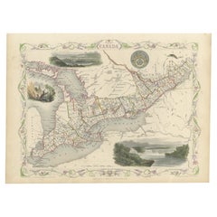
View AllAntique Map of West Canada by Tallis 'c.1850'
Located in Langweer, NL
Antique map titled 'West Canada'. Original antique map of West Canada, with decorative vignettes titled Kingston and Falls of Niagara. This map originates from 'The History and Topog...
Category
Antique Mid-19th Century Maps
Materials
Paper

$286 Sale Price
20% Off
Antique Map of Ontario with an Inset Map of the Niagara River by Johnson, 1872
Located in Langweer, NL
Antique map titled 'Johnson's Ontario, of the dominion of Canada (..)'. Original map of Ontario, Canada, with an inset map of the Niagara River and vicinity. This map originates from...
Category
Antique Late 19th Century Maps
Materials
Paper
$239 Sale Price
20% Off
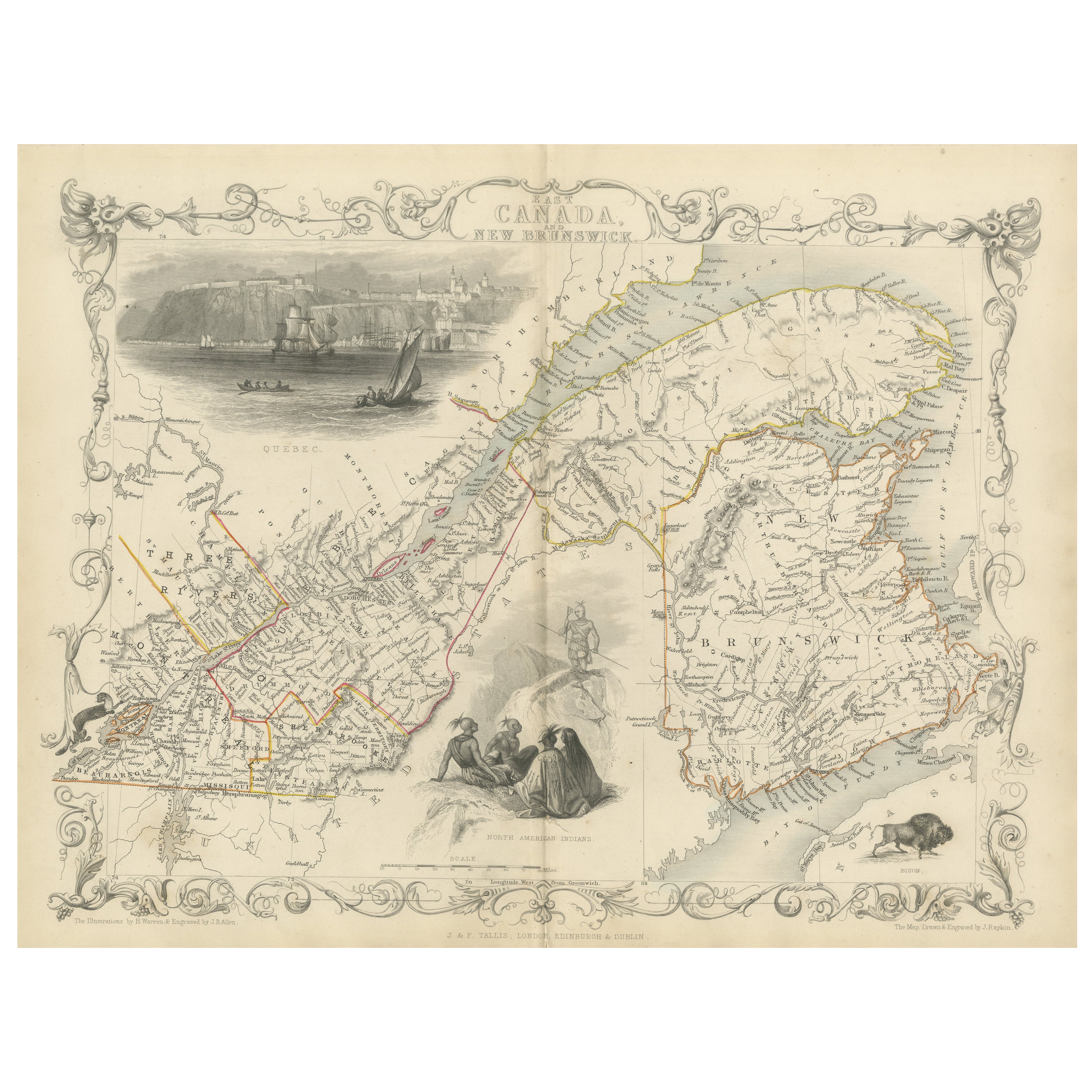
Decorative 1850s Map of Eastern Canada and New Brunswick with Historic Vignettes
Located in Langweer, NL
Decorative 1850s Map of Eastern Canada and New Brunswick with Historic Vignettes
This beautifully crafted 19th-century map of Eastern Canada and New Brunswick, drawn and engrave...
Category
Antique 1850s Maps
Materials
Paper

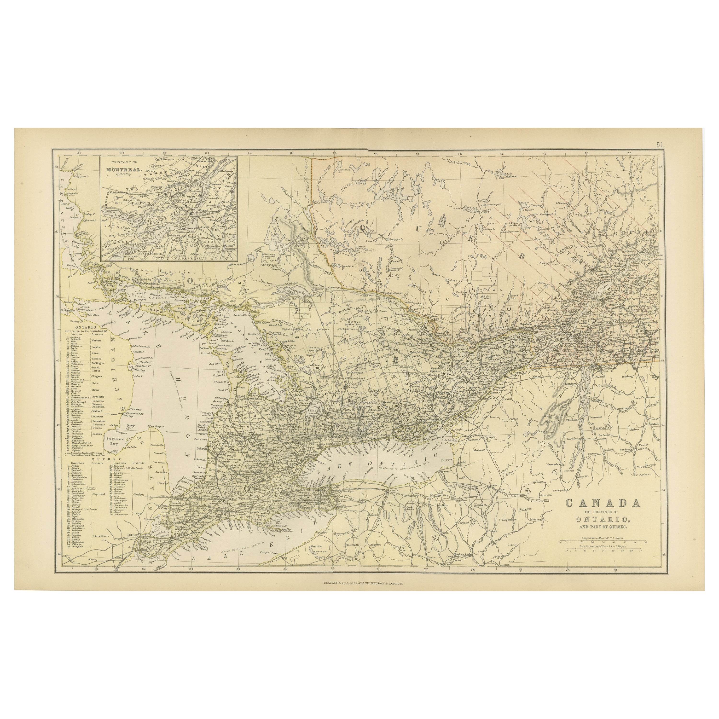
Antique Map of Canada, The Province of Ontario and Part of Quebec, 1882
Located in Langweer, NL
This is a historical map from the 1882 Blackie Atlas, this time detailing "The Province of Ontario, and Part of Quebec" in Canada. The map presents a detailed illustration of Ontario...
Category
Antique 1880s Maps
Materials
Paper

$239 Sale Price
20% Off
Free Shipping
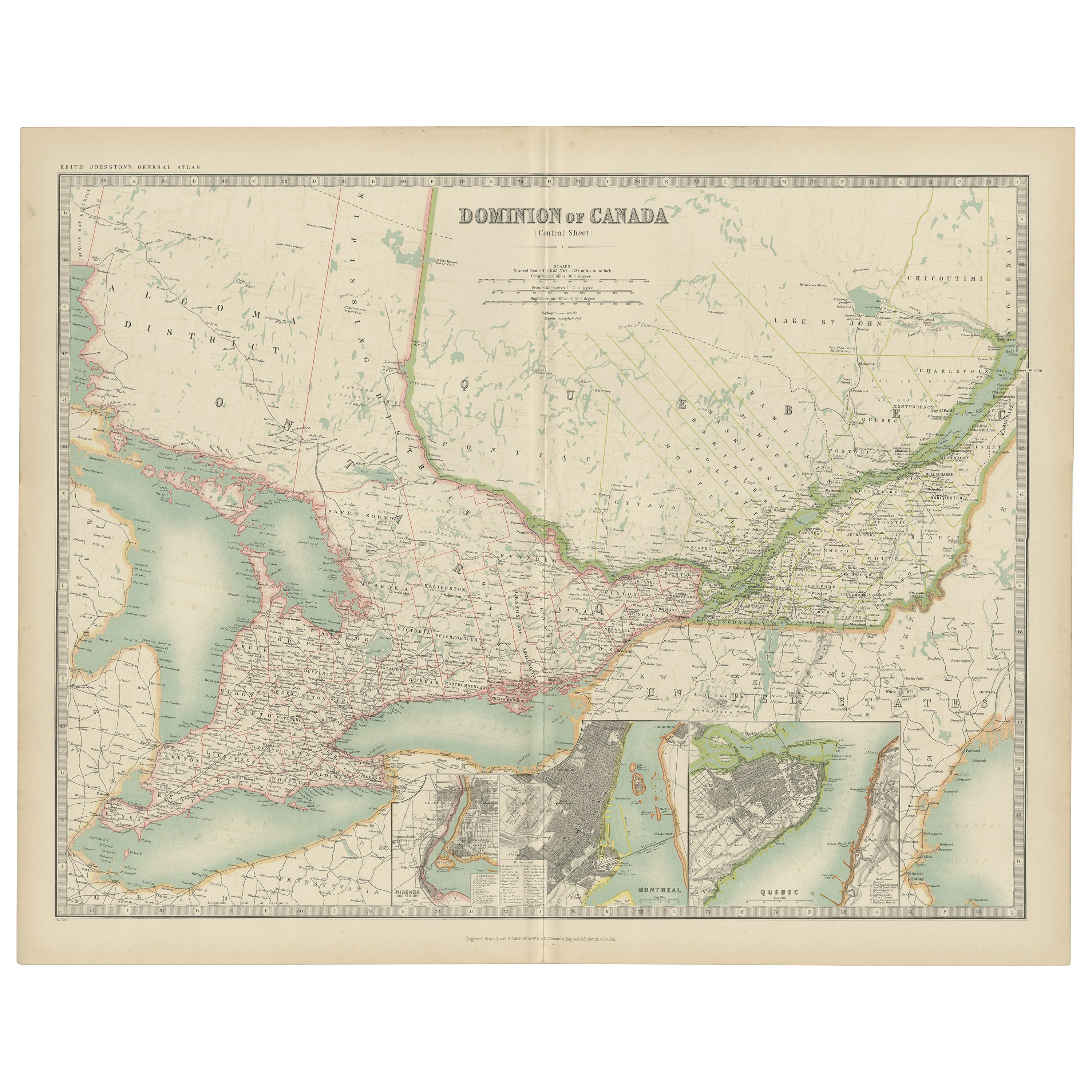
Antique Map of Canada by Johnston '1909'
Located in Langweer, NL
Antique map titled 'Dominion of Canada'. Original antique map of Canada. With inset maps of Niagara, Montreal, Quebec. This map originates from t...
Category
Early 20th Century Maps
Materials
Paper
$239 Sale Price
20% Off
Beautiful Decorative Hand-Colored Antique Map of West Canada, 1851
Located in Langweer, NL
Description: Antique map of Canada titled 'West Canada'.
With decorative vignettes titled Kingston and Falls of Niagara. Originates from 'The Illustrated Atlas, And Modern History Of The World Geographical, Political, Commercial & Statistical, Edited By R. Montgomery Martin'. Published; John Tallis London, New York, Edinburgh & Dublin. 1851.
Drawn and Engraved by J. Rapkin.
Artists and Engravers: John Tallis (1817-1876) was a British map...
Category
Antique 1850s Maps
Materials
Paper
$908 Sale Price
20% Off
You May Also Like
Original Antique Map of New Brunswick and Nova Scotia, 1889
Located in St Annes, Lancashire
Great map of New Brunswick and Nova Scotia
Drawn and Engraved by W. & A.K. Johnston
Published By A & C Black, Edinburgh.
Original colour
Unfr...
Category
Antique 1880s Scottish Victorian Maps
Materials
Paper

Original Antique Map of the American State of New York ( Western Part ) 1903
Located in St Annes, Lancashire
Antique map of New York ( Western Part )
Published By A & C Black. 1903
Original colour
Good condition
Unframed.
Free shipping
Category
Antique Early 1900s English Maps
Materials
Paper

Quebec. Canada. Century Atlas antique vintage map
Located in Melbourne, Victoria
'The Century Atlas. Quebec'
Original antique map, 1903.
Inset maps 'Sketch Map of Quebec', Quebec and Vicinity; and 'Montreal and Vicinity'.
Central fo...
Category
Early 20th Century Victorian More Prints
Materials
Lithograph

Original Antique Map of the American State of Michigan ( Northern Part ), 1903
Located in St Annes, Lancashire
Antique map of Michigan ( Northern part )
Published By A & C Black. 1903
Original colour
Good condition
Unframed.
Free shipping
Category
Antique Early 1900s English Maps
Materials
Paper

1858 Colton's Map of New York, Ric.B011
Located in Norton, MA
An 1858 Colton's map of New York
Ric.b011
Colton’s New York, 1858 - A large original color engraved and very detailed map of the state of New York,...
Category
Antique 19th Century Unknown Maps
Materials
Paper

Original Antique Map of North America by Dower, circa 1835
Located in St Annes, Lancashire
Nice map of North America
Drawn and engraved by J.Dower
Published by Orr & Smith. C.1835
Unframed.
Free shipping
Category
Antique 1830s English Maps
Materials
Paper

More Ways To Browse
Antique Rogers
Canadian Indigenous
China Silk Rug
Early English Silver
Italian Carved Dining Set
Antique Silver Basket
Black Crystal Glasses
Baker Furniture By
Oak Library
T Chair
Antique Italian Chairs
Antique Victorian Dining Tables
Veneer Dining Tables
Antique Brass And Copper
Antique English Country Furniture
Antique Russian Rugs
Beni Ourain Rugs
Glass Top Wood Base Coffee Tables