Maps
to
264
462
61
525
16
6
4
4
3
2
2
2,936
2,181
476
3
289
34
10
127
7
35
9
2
5
4
4
2
485
29
21
18
12
109
86
70
45
35
525
525
525
5
2
2
1
1
Maps For Sale
Period: 20th Century
Period: 1830s
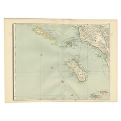
Antique Map of the Nias Archipelago, Sumatra, Indonsia, 1900
Located in Langweer, NL
Antique map of Nias Island and surrounding islands including the Banyak islands, Pini island and Simeulue Island. This map originates from 'Atlas van Nederlandsch Oost- en West-Indië...
Category
20th Century Maps
Materials
Paper
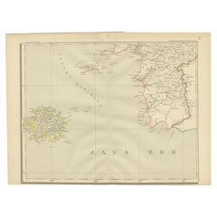
Antique Map of the Java Sea by Dornseiffen, 1900
Located in Langweer, NL
Antique map of the Java Sea. Also depicts Bilitung, the Karimata Islands and Sukadana, Borneo. This map originates from 'Atlas van Nederlandsch Oost- en West-Indië' by I. Dornseiffen...
Category
20th Century Maps
Materials
Paper
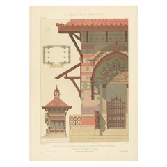
French Pavillon de la Grande Tuilerie, Chabat, Architectural Print, c.1900
Located in Langweer, NL
Antique print titled 'Pavillon de la Grande Tuilerie de Bourgogne (de Montghanin) Exposition Universelle de 1889, Mrs. Wulliam et Farge Architectes'. This print depicts the design of...
Category
20th Century Maps
Materials
Paper
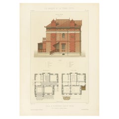
Pl. XLII Villa a Fontenay-Sous-Bois, Chabat, C.1900
Located in Langweer, NL
Antique print titled 'Villa A Fontenay-Sous-Bois, Mr. Ed. Jandelle-Ramier, Architecte'. This print depicts the design of a villa in France. Originates from 'La Brique et La Terre Cui...
Category
20th Century Maps
Materials
Paper
Pl. XXVIII Ecuries, Chabat, c.1900
Located in Langweer, NL
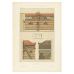
Antique print titled 'Ecuries (Boulevard Beauséjour) Mr. Pierre Chabat Architecte'. This print depicts the design of buildings in France. Originates from 'La Brique et La Terre Cuite...
Category
20th Century Maps
Materials
Paper
Antique Map of the Region of Utingeradeel by Meijer & Schaafsma, 1906
Located in Langweer, NL
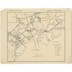
Antique map titled 'Gemeente Friesland. Gemeente Utingeradeel'. This map illustrates part of Friesland (The Netherlands) depicting Akkrum, Terkaple, Lekkerterp, Oldeboorn and more. Published by Tresling & Co, Amsterdam.
Artists and Engravers: Tresling and Co., Dutch Lithographers...
Category
20th Century Maps
Materials
Paper
Pl. VIII Villa a Luzarches, Chabat, c.1900
Located in Langweer, NL
Antique print titled 'Villa à Luzarches, Mr. Tronquois, Architecte'. This print depicts the design of a villa in France. Originates from 'La Brique et La Terre Cuite' by P. Chabat. A...
Category
20th Century Maps
Materials
Paper
Antique Architectural Print of Villa a Deauville in France, Chabat, c.1900
Located in Langweer, NL
Antique print titled 'Villa a Deauville, Mr. H. Blondel Architecte, Mr. Breney Architecte'. This print depicts the design of a building in France. Originates from 'La Brique et La Te...
Category
20th Century Maps
Materials
Paper
Architectural Building Design Print of Lycée Lakanal in France, Chabat, c.1900
Located in Langweer, NL
Antique print titled 'Lycée Lakanal a Sceaux (Seine) Mr. A. de Baudot Architecte'. This print depicts the design of a school in France. Originates from 'La Brique et La Terre Cuite' ...
Category
20th Century Maps
Materials
Paper
Pl. XLIV Maison A Neuilly 'Seine', Chabat, c.1900
Located in Langweer, NL
Antique print titled 'Maison A Neuilly (Seine) Mr. Paul Sédille, Architecte'. This print depicts the design of a building in France. Originates from 'La Brique et La Terre Cuite' by ...
Category
20th Century Maps
Materials
Paper
Pl. X Villa au Vésinet, Chabat, c.1900
Located in Langweer, NL
Antique print titled 'Villa au Vésinet (Seine et Oise) Mr. Héret Architecte'. This print depicts the design of a villa in France. Originates from 'La Brique et La Terre Cuite' by P. ...
Category
20th Century Maps
Materials
Paper
Antique Map of the Region of Banjarmasin, Indonesia 1900
Located in Langweer, NL
Antique Map of the Region of Banyuasin, Sumatra. Also depicting Bangka/Banka island. This map originates from 'Atlas van Nederlandsch Oost- en West-Indië' by I. Dornseiffen.
Artist...
Category
20th Century Maps
Materials
Paper
French Architectural Print of Souches de Cheminées - Chabat, c.1900
Located in Langweer, NL
Antique print titled 'Souches de Cheminées'. This print depicts the design of a building in France. Originates from 'La Brique et La Terre Cuite' by P. Chabat. Artists and Engravers:...
Category
20th Century Maps
Materials
Paper
Architectural Print of Villa Boulevard de Boulogne in France by Chabat, c.1900
Located in Langweer, NL
Antique print titled 'Villa Boulevard de Boulogne (Seine) Mr. L. Magne, Architecte'. This print depicts the design of a villa in France. Originates from 'La Brique et La Terre Cuite'...
Category
20th Century Maps
Materials
Paper
Old Street View in Guangzhou 'Canton' and Inhabitants of Guangzhou, China, 1834
Located in Langweer, NL
Antique print titled 'Une Rue de Canton - Barbier - Habitans de Canton'.
View of a street in Guangzhou (Canton) and inhabitants of Guangzhou, also includes a small image of a Chinese barber...
Category
1830s Antique Maps
Materials
Paper
Set of 11 Antique Maps of Japan Originating from a Japanese Atlas, 1906
Located in Langweer, NL
Set of 11 antique maps depicting various regions of Japan. These maps originate from a Japanese atlas, dated 1906. All text is in Japanese.
Category
20th Century Maps
Materials
Paper
Old Print of a Building Protecting the Warriors of Chief Palu, Tonga Tabu, 1836
Located in Langweer, NL
Antique print titled 'Anischt eines Schoppens der die Kriegspiroguen des Häuptlings Palu beschirmt'.
Old print of a building protecting the warriors of Chief Palu, Tonga Tabu. This print originates from 'Entdeckungs, Reise der Franzosischen Corvette Astrolabe Unternomen auf Befehl Konig Karls...
Category
1830s Antique Maps
Materials
Paper
Map of the Laughlan Islands, Rossel Island & Reef North of New Caledonia, 1833
Located in Langweer, NL
Antique map titled 'Plan de l'extremite septentrionale du Recif de D'entrecasteaux. Carte Particuliere d'un partie de l'Ile Rossel (Louisiade). Plan des Iles Laughlan.'
Map of th...
Category
1830s Antique Maps
Materials
Paper
Old Steel Engraved Map of the Western Part of the Madras Presidency, 1831
Located in Langweer, NL
Antique map titled 'India II Madras Presidency'.
Old steel engraved map of the western part of the Madras Presidency. The Madras Presidency, or the Presidency of Fort St. George, a...
Category
1830s Antique Maps
Materials
Paper
Antique Map of Denmark by Johnston '1909'
Located in Langweer, NL
Antique map titled 'Denmark'. Original antique map of Denmark. With inset maps of Iceland, Faroe Island, and Copenhagen. This map originates from the ‘Royal Atlas of Modern Geography...
Category
Early 20th Century Maps
Materials
Paper
Antique Map of Central Java Depicting The Karimun Islands, Indonesia, 1900
Located in Langweer, NL
Antique map of Central Java, also depicting the Karimun Islands. This map originates from 'Atlas van Nederlandsch Oost- en West-Indië' by I. Dornseiffen. ...
Category
20th Century Maps
Materials
Paper
Original Old Map of Eastern China, Also Depicting Taiwan 'Formosa', 1922
Located in Langweer, NL
Large map of China titled 'China - Peking'. Old map of eastern China depicting Kiangsi, Chekiang, Fukien, Kwangtung, Taiwan (Formosa) and surroundings. With inset map of Peking. This...
Category
20th Century Maps
Materials
Paper
Antique Map of the Dutch Provinces Groningen and Friesland, 1902
Located in Langweer, NL
Antique map titled 'Groningen en Friesland'. Lithographed map of the provinces of Groningen and Friesland, the Netherlands. This map originates from 'Atlas van Nederland'. Artists an...
Category
20th Century Maps
Materials
Paper
Antique Map of Turkey in Europe with Bulgaria by Johnston '1909'
Located in Langweer, NL
Antique map titled 'Turkey in Europe with Bulgaria'. Original antique map of Turkey in Europe with Bulgaria. With inset maps of The Bosporus & Constantinople, and Crete (or Candia). ...
Category
Early 20th Century Maps
Materials
Paper
Antique Map of Canada by Johnston '1909'
Located in Langweer, NL
Antique map titled 'Dominion of Canada'. Original antique map of Canada. With inset map of Newfoundland. This map originates from the ‘Royal Atla...
Category
Early 20th Century Maps
Materials
Paper
Vintage Road Map of the Netherlands '1928'
Located in Langweer, NL
Vintage map titled 'Volgens het vijfjarig Werkplan te verbeteren Rijkswegen en nieuw aan te leggen wegen welke voorkomen op het Rijkswegenplan'. Map of the Netherlands...
Category
20th Century Maps
Materials
Paper
Antique Map of Abyssinia with Upper Nubia by Johnston, '1909'
Located in Langweer, NL
Antique map titled 'Abyssinia with Upper Nubia'. Original antique map of Abyssinia with Upper Nubia. This map originates from the ‘Royal Atlas of Modern Geography’. Published by W. &...
Category
Early 20th Century Maps
Materials
Paper
Antique Map of the United States of North America by Johnston '1909'
Located in Langweer, NL
Antique map titled 'United States of North America'. Original antique map of United States of North America ( South West Sheet ). With inset maps of Chicago...
Category
Early 20th Century Maps
Materials
Paper
Antique Map of Turkey in Asia by Johnston '1909'
Located in Langweer, NL
Antique map titled 'Turkey Asia ( Asia Minor )'. Original antique map of Turkey in Asia. This map originates from the ‘Royal Atlas of Modern Geog...
Category
Early 20th Century Maps
Materials
Paper
Antique Map of Central Asia by Johnston '1909'
Located in Langweer, NL
Antique map titled 'Central Asia'. Original antique map of Central Asia. This map originates from the ‘Royal Atlas of Modern Geography’. Published by W. & A.K. Johnston, 1909.
Category
Early 20th Century Maps
Materials
Paper
Antique Map of the German Empire by Johnston, '1909'
Located in Langweer, NL
Antique map titled 'Empire of Germany'. Original antique map of the German Empire. With inset maps of Berlin and Potsdam. This map originates from the ‘R...
Category
Early 20th Century Maps
Materials
Paper
Antique Map of France by Johnston (1909)
Located in Langweer, NL
Antique map titled 'France'. Original antique map of France. With inset maps of France in provinces, part of the Riviera and Corsica. This map or...
Category
Early 20th Century Maps
Materials
Paper
Antique Map of Asia by Johnston '1909'
Located in Langweer, NL
Antique map titled 'Asia'. Depicting China, Japan, Indonesia, India, Arabia and more. This map originates from the ‘Royal Atlas of Modern Geography’. Published by W. & A.K. Johnston,...
Category
Early 20th Century Maps
Materials
Paper
Antique Chart of the World by Johnston '1909'
Located in Langweer, NL
Antique map titled 'Chart of the World on Mercator's Projection Showing the directions of the Oceans Currents with the Routes and Distances Between Principal Ports'. Detailed map of ...
Category
Early 20th Century Maps
Materials
Paper
Antique Map of Egypt, Arabia Petraea and Lower Nubia by Johnston '1909'
Located in Langweer, NL
Antique map titled 'Egypt, Arabia Petraea and Lower Nubia'. Original antique map of Egypt, Arabia Petraea and Lower Nubia. With inset maps of Alexandriam Cairo and the Suez Canal...
Category
Early 20th Century Maps
Materials
Paper
Antique Map of Belgium and the Netherlands by Johnston 'c.1920'
Located in Langweer, NL
Antique map titled 'Belgium and the Netherlands'. Original antique map of Belgium and the Netherlands. Published by W. & A.K. Johnston, circa 1920.
Category
20th Century Maps
Materials
Paper
1939 "A Good-Natured Map of the United States" by Greyhound
Located in Colorado Springs, CO
Presented is an original 1939 map, titled “A Good-Natured Map of the United States Setting Forth the Services of the Greyhound Lines and a Few Principal Connecting Bus Lines.” This brightly colored pictographic map was one of several similar United States maps...
Category
1930s American Art Deco Vintage Maps
Materials
Paper
Antique Map of the Orange River Colony in South Africa, 1901
Located in Langweer, NL
Antique map titled 'Orange River Colony, northern part'. Lithograph of the northern part of the Orange River Colony, Africa. The Orange River Colony was the British colony created af...
Category
Early 20th Century Maps
Materials
Paper
Art Deco Cartoon Style Map of Paris possibly by Arthur Zaindenberg circa 1930's
By Arthur Zaidenberg
Located in New York, NY
Art Deco cartoon style map of Paris possibly by Arthur Zaidenberg. The map depicts witty references to Parisians lifestyle, along with drawings of notable landmarks, circa 1930's. T...
Category
1930s American Art Deco Vintage Maps
Materials
Paper
Vintage Framed United States Map
Located in Queens, NY
Vintage aged paper map of the United States mounted on particle board and framed in a simple wooden frame.
Category
20th Century American Mid-Century Modern Maps
Materials
Wood, Paper
Antique Webber Costello Globe on Metal Tripod Base c 1900 / 1920's
Located in New York, NY
Rare floor model globe made by Weber Costello, circa 1900. The 12" globe rests on a folding metal base. This example is in very good, original condition, showing only light wear, nor...
Category
Early 20th Century American Industrial Maps
Materials
Metal
1918 American Frohse Anatomical Chart, A. J. Nystrom, Max Brodel Illustrator
By A.J. Nystrom & Co, Max Brödel
Located in Buffalo, NY
Antique American Frohse Anatomical pull down chart, by A. J. Nystrom, ,revised and augmented by Max Brodel illustrator... Amazing color, patina, age appropriate wear. dated 1918..
Max (Paul Heinrich) Brödel
1870-1941
Brödel, an illustrator and the first director of the Art as Applied to Medicine program at Johns Hopkins...
Category
1910s American Steampunk Vintage Maps
Materials
Wood, Paper
"The United States from the Latest Authorities" Antique Wall Map, 1835
Located in Colorado Springs, CO
This is a 1835 map of “The United States from the Latest Authorities” by Ezra Strong. A hand-colored engraved wall map of the eastern half of the United States, this map has a large inset of the "Oregon District" and several engraved city views and two portraits.
The primary map extends to Mexico Texas and the Missouri Territory, showing the course of the Missouri River to Ft. Mandan and Old Ft. Mandan, and noting many forts along the river. The territories to the east of Missouri Territory are separately delineated as Sioux District and Huron District. The western details of the map are very good for a map of this time period, with many Native American settlements, villages, forts and other details noted.
The map is bordered with vignettes of Boston, New York, Philadelphia, Hartford, Cincinnati, and Baltimore. Each vignette notes the date settled, primary settler, and the population as of 1830. Two portraits of LaFayette and George Washington are presented in full length with related biographical information.
A large inset map at lower right shows the Oregon District, centered on the Columbia River and extending to the Rocky Mountains. This is one of the earliest commercial appearances of a separate map of Oregon...
Category
1830s American Antique Maps
Materials
Paper
Cram's 16" Deluxe Globe W/Daily Sun Ray and Season Indicator
Located in San Francisco, CA
Cram's 16" Deluxe Globe W/Daily Sun Ray and Season Indicator
1936
Category
1930s Vintage Maps
Materials
Metal
East German Map
By VEB Hermann Haack
Located in Baltimore, MD
A brilliantly colourful map of the Leipzig, Karl Marx Stadt and Dresden area in the former German Democratic Republic by VEB Hermann Haack of Gotha.
Category
1970s German Vintage Maps
1943 "USO Map Guide to Washington"
Located in Colorado Springs, CO
This is a WWII map of Washington, DC, issued as a guide for service men and women visiting or working in the city during the war. The map was created by Allen F. Free and published a...
Category
1940s American Mid-Century Modern Vintage Maps
Materials
Paper
Antique Map of the West Indies and Ambon in Indonesia, 1900
Located in Langweer, NL
Two maps on one sheet titled 'De West-Indische Eilanden (Nederlandsch Gedeelte)' and 'Ambon, Leasi-Eilanden en Banda-Eilanden'. Old map of the Dutch West Indies and Ambon Island, Ind...
Category
20th Century Maps
Materials
Paper
Antique Political Map of Eastern China, 1922
Located in Langweer, NL
Antique map of China titled 'Eastern China - Political Map'. Old map of eastern China depicting Kiangsi, Chekiang, Fukien, Kwangtung, Taiwan (Formosa) an...
Category
20th Century Maps
Materials
Paper
George Philip's Large Relief Map of the World 150x110cm
Located in Linkebeek, BE
George Philip's Large Relief Map of the World 150x110cm
PHILIP, George Relief Map of the World. George Philip and Son Limited, c. 1950. Large 3D relief map of the world. Shaded relie...
Category
20th Century British Maps
Materials
Plastic, Wood
Original French Antique Map of the Russian Empire, 1837
Located in Langweer, NL
Antique map titled 'Tableau Historique et Géographique de L'Empire de Russie'.
Original antique map of the Russian Empire will detailed written information about the chronology, ...
Category
1830s Antique Maps
Materials
Paper
Old Handcolored Print of a Regiment of the Belgium Army, 1833
Located in Langweer, NL
One nicely hand colored print of an original serie of 23 plates, showing soldiers discussing matters in a village. published in 1833. Rare.
From a serie of beautiful lithographed plates with Belgian military costumes after Madou and printed by Dero-Becker. Comes from a Belgian military costume album, dedicated to the Belgian King, and financed by subscribers, some 90 Belgian nobility and officers of the Belgian Army...
Category
1830s Antique Maps
Materials
Paper
Antique Map of the Batu Islands by Dornseiffen, 1900
Located in Langweer, NL
Antique map of the Batu Islands with the large title 'Soematra, Bangka en de Riouw-Lingga Archipel'. This map originates from 'Atlas van Nederlandsch Oost- en West-Indië' by I. Dorns...
Category
20th Century Maps
Materials
Paper
Pl. XIV Remise De Locomotives, Chabat, c.1900
Located in Langweer, NL
Antique print titled 'Remise de Locomotives'. This print depicts the design of locomotives and a station. Originates from 'La Brique et La Terre Cuite' by P. Chabat. Artists and Engr...
Category
20th Century Maps
Materials
Paper
Pl. VII Villa a Luzarches, Chabat, C.1900
Located in Langweer, NL
Antique print titled 'Villa a Luzarches, Mr. Tronquois, Architecte'. This print depicts the design of a building in France. Originates from 'La Brique et La Terre Cuite' by P. Chabat...
Category
20th Century Maps
Materials
Paper
Pl. XXXIII Villa Eugène Decan, Chabat, c.1900
Located in Langweer, NL
Antique print titled 'Villa Eugène Decan, Villers-Sur-Mer'. This print depicts the design of a building in France. Originates from 'La Brique et La Terre Cuite' by P. Chabat. Artists...
Category
20th Century Maps
Materials
Paper
Architectural Print of Pharmacie Gymnase in France, Chabat, c.1900
Located in Langweer, NL
Antique print titled 'Pharmacie Gymnase, École Nationale Professionnelle d'Armentières, Mr. Charles Chipiez Architecte'. This print depicts the design of a building in France. Origin...
Category
20th Century Maps
Materials
Paper
Pl. XXII Maison rue Friant, Chabat, c.1900
Located in Langweer, NL
Antique print titled 'Maison rue Friant. Mr. A. Hedin, Architecte'. This print depicts the design of a building in France. Originates from 'La Brique et La Terre Cuite' by P. Chabat....
Category
20th Century Maps
Materials
Paper
Pl. XXIX Restaurant de Bercy, Chabat, c.1900
Located in Langweer, NL
Antique print titled 'Restaurant de Bercy, Mr. l 'Heureux Architecte'. This print depicts the design of a restaurant in France. Originates from 'La Brique et La Terre Cuite' by P. Ch...
Category
20th Century Maps
Materials
Paper
