Maps
to
128
268
21
289
3
3
2
1
2,926
2,181
476
3
289
34
10
127
7
35
9
2
5
3
4
2
279
12
9
9
2
80
76
63
22
15
289
289
289
5
1
1
1
1
Maps For Sale
Period: Early 20th Century
Period: Early 1900s
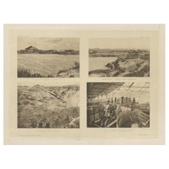
Four Rare Heliograph Views of Mining Near Sungei Bessi River in Malaysia, 1907
Located in Langweer, NL
Four views of early Mining operations in Malaysia at the beginning of the 20th century. Published in 1907.
1) A Sand-Lake of Residue (Sungai of Sungei Bessi)
2) Chinese Smelting...
Category
Early 1900s Antique Maps
Materials
Paper
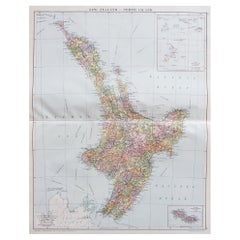
Large Original Vintage Map of New Zealand, North Island, circa 1920
Located in St Annes, Lancashire
Great map of North Island, New Zealand
Original color.
Good condition / minor foxing to right edge
Published by Alexander Gross
Unframed.
Category
1920s English Edwardian Vintage Maps
Materials
Paper
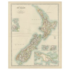
Antique Map of New Zealand by Johnston '1909'
Located in Langweer, NL
Antique map titled 'New Zealand'. Original antique map of New Zealand. With inset maps of Chatham, Auckland, Wellington, Dunedin, and New Gu...
Category
Early 20th Century Maps
Materials
Paper
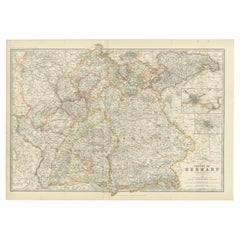
Antique Map of Germany by Johnston '1909'
Located in Langweer, NL
Antique map titled 'Empire of Germany'. Original antique map of Germany. With inset maps of Frankfurt and Munich. This map originates from the ‘...
Category
Early 20th Century Maps
Materials
Paper
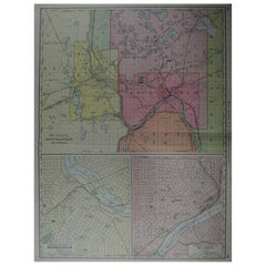
Large Original Antique City Plan of Minneapolis and St Paul, USA, circa 1900
Located in St Annes, Lancashire
Fabulous colorful map of Minneapolis and St Paul, Minnesota.
Original color
By Rand, McNally & Co.
Published, circa 1900
Unframed
Minor edge tears
Free shipping.
Category
Early 1900s American Antique Maps
Materials
Paper
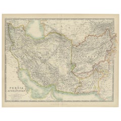
Antique Map of Persia and Afghanistan by Johnston '1909'
Located in Langweer, NL
Antique map titled 'Persia and Afghanistan'. Original antique map of Persia and Afghanistan. This map originates from the ‘Royal Atlas o...
Category
Early 20th Century Maps
Materials
Paper
Antique Map of the United States of North America by Johnston '1909'
Located in Langweer, NL
Antique map titled 'United States of North America'. Original antique map of United States of North America ( South West Sheet ). With inset maps of Chicago...
Category
Early 20th Century Maps
Materials
Paper
Antique Map of Austria- Hungary by Johnston, '1909'
Located in Langweer, NL
Antique map titled 'Austria- Hungary'. Original antique map of Austria- Hungary. This map originates from the ‘Royal Atlas of Modern Geography’....
Category
Early 20th Century Maps
Materials
Paper
Original Antique Map of England and Wales from the 1909 Royal Atlas
Located in Langweer, NL
The antique map titled 'England and Wales' is a historical cartographic representation of these two nations. This original antique map of England...
Category
Early 20th Century Maps
Materials
Paper
Antique Map of the United States ' North East ' by Johnston '1909'
Located in Langweer, NL
Antique map titled 'United States of North America'. Original antique map of United States of North America ( North East ). This map orig...
Category
Early 20th Century Maps
Materials
Paper
Large Sea Chart of the British Islands, 1918
Located in Langweer, NL
Antique map titled 'The British Islands'.
Large sea chart of the British Islands. It shows Ireland, Scotland, England, the Shetland Islands and part of Fra...
Category
1910s Vintage Maps
Materials
Paper
Antique Map of Denmark by Johnston '1909'
Located in Langweer, NL
Antique map titled 'Denmark'. Original antique map of Denmark. With inset maps of Iceland, Faroe Island, and Copenhagen. This map originates from the ‘Royal Atlas of Modern Geography...
Category
Early 20th Century Maps
Materials
Paper
Antique Map of Turkey in Europe with Bulgaria by Johnston '1909'
Located in Langweer, NL
Antique map titled 'Turkey in Europe with Bulgaria'. Original antique map of Turkey in Europe with Bulgaria. With inset maps of The Bosporus & Constantinople, and Crete (or Candia). ...
Category
Early 20th Century Maps
Materials
Paper
Antique Map of Canada by Johnston '1909'
Located in Langweer, NL
Antique map titled 'Dominion of Canada'. Original antique map of Canada. With inset map of Newfoundland. This map originates from the ‘Royal Atla...
Category
Early 20th Century Maps
Materials
Paper
Antique Map of Abyssinia with Upper Nubia by Johnston, '1909'
Located in Langweer, NL
Antique map titled 'Abyssinia with Upper Nubia'. Original antique map of Abyssinia with Upper Nubia. This map originates from the ‘Royal Atlas of Modern Geography’. Published by W. &...
Category
Early 20th Century Maps
Materials
Paper
Antique Map of Turkey in Asia by Johnston '1909'
Located in Langweer, NL
Antique map titled 'Turkey Asia ( Asia Minor )'. Original antique map of Turkey in Asia. This map originates from the ‘Royal Atlas of Modern Geog...
Category
Early 20th Century Maps
Materials
Paper
Antique Map of Central Asia by Johnston '1909'
Located in Langweer, NL
Antique map titled 'Central Asia'. Original antique map of Central Asia. This map originates from the ‘Royal Atlas of Modern Geography’. Published by W. & A.K. Johnston, 1909.
Category
Early 20th Century Maps
Materials
Paper
Antique Map of the German Empire by Johnston, '1909'
Located in Langweer, NL
Antique map titled 'Empire of Germany'. Original antique map of the German Empire. With inset maps of Berlin and Potsdam. This map originates from the ‘R...
Category
Early 20th Century Maps
Materials
Paper
Antique Map of France by Johnston (1909)
Located in Langweer, NL
Antique map titled 'France'. Original antique map of France. With inset maps of France in provinces, part of the Riviera and Corsica. This map or...
Category
Early 20th Century Maps
Materials
Paper
Antique Map of Asia by Johnston '1909'
Located in Langweer, NL
Antique map titled 'Asia'. Depicting China, Japan, Indonesia, India, Arabia and more. This map originates from the ‘Royal Atlas of Modern Geography’. Published by W. & A.K. Johnston,...
Category
Early 20th Century Maps
Materials
Paper
Antique Chart of the World by Johnston '1909'
Located in Langweer, NL
Antique map titled 'Chart of the World on Mercator's Projection Showing the directions of the Oceans Currents with the Routes and Distances Between Principal Ports'. Detailed map of ...
Category
Early 20th Century Maps
Materials
Paper
Antique Map of Egypt, Arabia Petraea and Lower Nubia by Johnston '1909'
Located in Langweer, NL
Antique map titled 'Egypt, Arabia Petraea and Lower Nubia'. Original antique map of Egypt, Arabia Petraea and Lower Nubia. With inset maps of Alexandriam Cairo and the Suez Canal...
Category
Early 20th Century Maps
Materials
Paper
Antique European War Folding Map, ‘circa 1915’
Located in Langweer, NL
Antique folding map of the European War (1914-1915) titled 'The Eastern Campaign '. From Petrograd to Berlin, geographically colored. Published on linen b...
Category
Early 20th Century Maps
Materials
Paper
Antique Map of the Orange River Colony in South Africa, 1901
Located in Langweer, NL
Antique map titled 'Orange River Colony, northern part'. Lithograph of the northern part of the Orange River Colony, Africa. The Orange River Colony was the British colony created af...
Category
Early 20th Century Maps
Materials
Paper
Early 20th Century American Library Globe
Located in Norwell, MA
Fine library globe with makers logo from Atlas School Supply Co., Chicago. Hardwood base with rich finish and nice detail. Celestial globe with equ...
Category
1920s North American Vintage Maps
Materials
Wood
1918 American Frohse Anatomical Chart, A. J. Nystrom, Max Brodel Illustrator
By Max Brödel, A.J. Nystrom & Co
Located in Buffalo, NY
Antique American Frohse Anatomical pull down chart, by A. J. Nystrom, ,revised and augmented by Max Brodel illustrator... Amazing color, patina, age appropriate wear. dated 1918..
Max (Paul Heinrich) Brödel
1870-1941
Brödel, an illustrator and the first director of the Art as Applied to Medicine program at Johns Hopkins...
Category
1910s American Steampunk Vintage Maps
Materials
Wood, Paper
1923 "Washington, The Beautiful Capital of the Nation" Baltimore and Ohio RR Map
Located in Colorado Springs, CO
This is a fabulous 1923 bird's eye map of Washington, DC that shows the city in amazing detail. Every building is individually drawn and all major roads in the city are shown. The vi...
Category
1920s American Art Deco Vintage Maps
Materials
Paper
Antique Webber Costello Globe on Metal Tripod Base c 1900 / 1920's
Located in New York, NY
Rare floor model globe made by Weber Costello, circa 1900. The 12" globe rests on a folding metal base. This example is in very good, original condition, showing only light wear, nor...
Category
Early 20th Century American Industrial Maps
Materials
Metal
"Atlas to Accompany Monograph XXXII on the Geology of Yellowstone National Park"
By United States Geological Survey
Located in Colorado Springs, CO
This is an original 1904 "Atlas to Accompany Monograph XXXII on the Geology of the Yellowstone National Park" by Arnold Hague. Published by the Department of the Interior, the Atlas ...
Category
Early 1900s American Antique Maps
Materials
Leather, Fabric, Paper
Rare and Early Plaster Relief Map of Adirondack Mountains by F J H Merrill
By P.F. Howells, E. W. Merrill
Located in Buffalo, NY
Rare and Early Monumental Plaster Relief Map of Adirondack Mountains by The University of the State of New York, New York State Museum..F J H Merrill director,,,modeled by Howell's ...
Category
1910s American Industrial Vintage Maps
Materials
Plaster, Wood
Vintage Swedish Topographic School Map of European Alps, Made in Sweden 1922
Located in Los Angeles, CA
Vintage Swedish Topographic School map of European Alps, Made in Sweden 1922
This vintage Swedish school map is so unique and a great example of why t...
Category
1920s Swedish Vintage Maps
Materials
Linen, Wood, Paper
1915 "San Francisco City and County" Hanging Map by W. Bashford Smith
Located in Colorado Springs, CO
Presented is a rare wall map of San Francisco by W. Bashford Smith. Published in San Francisco in 1915, this map indicates streets and city districts, and, most notably, shows the si...
Category
1910s American Art Deco Vintage Maps
Materials
Wood, Paper
Antique Map of India ( Southern ) by Johnston (1909)
Located in Langweer, NL
Antique map titled 'India'. Original antique map of India Southern sheet. With inset maps of south eastern provinces of India. This map originates from the ‘Royal Atlas of Modern Geo...
Category
Early 20th Century Maps
Materials
Paper
Antique Map of Spain and Portugal by Johnston, '1909'
Located in Langweer, NL
Antique map titled 'Spain and Portugal'. Original antique map of Spain and Portugal. With inset maps of the Canary Islands, Madeira, Lisbon and Ma...
Category
Early 20th Century Maps
Materials
Paper
Antique Map of the United States 'North West' by Johnston, '1909'
Located in Langweer, NL
Antique map titled 'United States of North America'. Original antique map of the United States of North America ( North West ). This map originates from the ‘Royal Atlas of Modern Ge...
Category
Early 20th Century Maps
Materials
Paper
Antique Map of India 'Northern' by Johnston '1909'
Located in Langweer, NL
Antique map titled 'India'. Original antique map of India, Northern sheet. This map originates from the ‘Royal Atlas of Modern Geography’. Published by W. & A.K. Johnston, 1909.
Category
Early 20th Century Maps
Materials
Paper
Antique Map of Belgium and the Netherlands by Johnston '1909'
Located in Langweer, NL
Antique map titled 'Belgium and The Netherlands'. Original antique map of Belgium and the Netherlands. With inset maps of Amsterdam and Brussels. This m...
Category
Early 20th Century Maps
Materials
Paper
Antique Map of Scotland 'Northern' by Johnston, '1909'
Located in Langweer, NL
Antique map titled 'Scotland'. Original antique map of Scotland. With inset map of the Shetland Islands. This map originates from the ‘Royal Atlas of M...
Category
Early 20th Century Maps
Materials
Paper
Antique Map of Sweden and Norway by Johnston (1909)
Located in Langweer, NL
Antique map titled 'Sweden and Norway'. Original antique map of Sweden and Norway. With inset maps of Christiania and Stockholm. This map originates from...
Category
Early 20th Century Maps
Materials
Paper
Antique Map of South-West Russia by Johnston (1909)
Located in Langweer, NL
Antique map titled 'South-West Russia'. Original antique map of South-West Russia. With inset map of Odessa. This map originates from the ‘Royal Atlas of Modern Geography’. Published...
Category
Early 20th Century Maps
Materials
Paper
Antique Map of South America by Johnston '1909'
Located in Langweer, NL
Antique map titled 'South America, Southern Sheet'. Depicting Chile, Argentina, Brazil, Patagonia, the Falkland Island and more. With inset maps of Valparaiso, Rio de Janeiro and Bue...
Category
Early 20th Century Maps
Materials
Paper
1850-1960 Cram's Superior Latest Federal Census Texas Map
By G. F. Cram Company
Located in New York, NY
The 1850-1960 Cram's Superior Latest Federal Census Texas Map, crafted from pine wood, steel, and canvas, is a valuable historical cartographic piece. Publi...
Category
1910s American Vintage Maps
Materials
Canvas
Antique Map of the East Indies by Brouwer, 1917
Located in Langweer, NL
Antique map titled 'Geotektonische Schetskaart van het Oostelijk Gedeelte van den Oost-Indischen Archipel':
**Title**: Geotektonische Schetskaart van het Oostelijk Gedeelte van den ...
Category
Early 20th Century Maps
Materials
Canvas, Paper
Antique Plan of Paramaribo 'Suriname' Published 1920
Located in Langweer, NL
Large lithographed plan of Paramaribo, capital city of Suriname, showing the situation, circa 1916-1917. With small inset plan. Published in 1920.
Category
Early 20th Century Maps
Materials
Paper
Antique Map of Northern Natal by Stanford, 1900
Located in Langweer, NL
Antique map titled 'Northern Natal'. Lithograph of Northern Natal. The Colony of Natal was a British colony in south-eastern Africa. It was proclaimed a British colony on 4 May 1843 ...
Category
Early 20th Century Maps
Materials
Paper
Mamaroneck New York Harbor Chart from 1901
Located in Norwell, MA
Original harbor chart by George Eldridge in 1801 of Mamaroneck New York. Showing Oriental Hen Island, Rye Point, Scotch Caps, Crane Island, Decency Point, etc.. Showing local water d...
Category
Early 1900s North American Antique Maps
Materials
Paper
1912 "Panoramic View of New York City and Vicinity" by Jacob Ruppert
Located in Colorado Springs, CO
This is an attractive and very scarce map of New York, published by the Yorkville brewer Jacob Ruppert in 1912. The map shows an expansive view of the region reaching from Sandy Hook in the south and Yonkers to the north, to Hicksville in the east and past Newark to the west. This beautifully colored birds eye view shows waterways with all shipping traffic, boroughs, and clearly labeled railroad routes. It is presented on period dowels and backed on its original linen.
Jacob Ruppert was born in New York City in 1842 to Bavarian immigrants. His father owned a brewery in Manhattan where young Jacob learned the business of brewing. In 1862, Jacob established the Jacob...
Category
1910s American Vintage Maps
Materials
Paper
Vintage Swedish School Map of Vastergötland, Made in Sweden 1920
Located in Los Angeles, CA
Vintage Swedish School Map of Vastergötland, Made in Sweden 1920
Västergötland also known as West Gothland or the Latinized version Westrogothia in older literature, is one of the...
Category
1920s Swedish Vintage Maps
Materials
Linen, Wood, Paper
Northwest Coast and Isle of Man Map
Located in Cheshire, GB
Greenville Collins Northwest Coast and Isle of Man. hand coloured chart, encased in an ebonised frame.
Dimensions
Height 26.5 Inches
Width 30 Inches
Depth 1 Inches
Category
Early 20th Century British Maps
Materials
Paper
Chart of the Harbour of Liverpool
Located in Cheshire, GB
PL Burdett A Chart of the Harbour of Liverpool hand coloured. Encased in an ebonised frame.
Dimensions
Height 23.5 Inches
Width 28 Inches
Depth 1 Inches
Category
Early 20th Century British Maps
Materials
Paper
Map of Lancashire
Located in Cheshire, GB
Saxton Map of Lancashire hand coloured. Encased in an ebonised frame.
Dimensions
Height 21 Inches
Width 24 Inches
Depth 1 Inches
Category
Early 20th Century British Maps
Materials
Paper
Mariners Chart of Quicks Hole and Tarpaulin Cove by George Eldridge 1901
Located in Norwell, MA
Nautical chart showing the harbor and local waters of Naushon Island Quick Holes. The chart display depths buoys, lightness, etc., The chart shows the cove in Naushon with ships stor...
Category
Early 1900s North American Antique Maps
Materials
Paper
University Chart “Black Map of North America
Located in Godshill, Isle of Wight
University Chart “Black Map of North America
W&A K Johnston’s Charts of Physical Maps By G W Bacon,
This is a Black Physical map of North A...
Category
Early 20th Century Industrial Maps
Materials
Linen
Large University Chart “Political Map of North America” by Bacon
Located in Godshill, Isle of Wight
Large University Chart “Political Map of North America” by Bacon
W&A K Johnston’s Charts of Physical Maps By G W Bacon,
This is colourful Physical map ...
Category
Early 20th Century American Empire Maps
Materials
Linen
Large University Chart “Political Map of North America” by Bacon
Located in Godshill, Isle of Wight
Large University chart “Political Map of North America” by Bacon
W&A K Johnston’s Charts of Political Maps by G W Bacon,
This is colorful Physical ...
Category
Early 20th Century American Empire Maps
Materials
Linen
Large University Chart “Africa Physical ” by Bacon
Located in Godshill, Isle of Wight
Large University chart “Africa Physical ” by Bacon
W&A K Johnston’s charts of physical maps by G W Bacon,
This is a Physical map of Africa, it is lithograph set on Linen mounte...
Category
Early 20th Century Beaux Arts Maps
Materials
Linen
Large University Chart “Physical Map of Africa” by Bacon
Located in Godshill, Isle of Wight
Large university chart “Physical Map of Africa” by Bacon
W&A K Johnston’s Charts of Physical Maps By G W Bacon,
This is colorful Physical map of North America, it is large lithograph set...
Category
Early 20th Century Folk Art Maps
Materials
Linen
