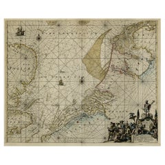
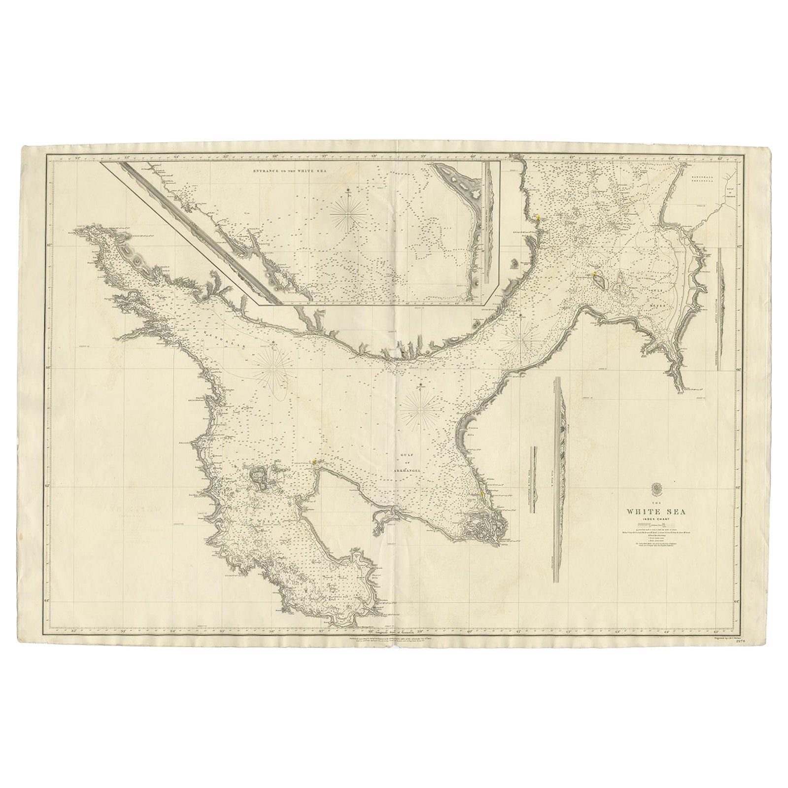
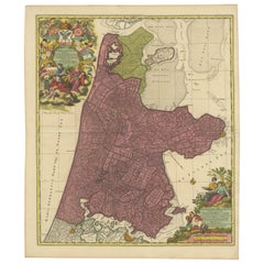
Antique Coastal Chart of the North Sea between England and the Netherlands, 1730
View Similar Items


Want more images or videos?
Request additional images or videos from the seller
1 of 5
Antique Coastal Chart of the North Sea between England and the Netherlands, 1730
About the Item
- Dimensions:Height: 20.63 in (52.4 cm)Width: 24.53 in (62.3 cm)Depth: 0 in (0.02 mm)
- Materials and Techniques:
- Period:1730-1739
- Date of Manufacture:circa 1730
- Condition:Repaired: backed using contemporary paper backed with acid free archival tape. Wear consistent with age and use.
- Seller Location:Langweer, NL
- Reference Number:Seller: PCT-56381 1stDibs: LU3054326706672
About the Seller
5.0
Recognized Seller
These prestigious sellers are industry leaders and represent the highest echelon for item quality and design.
Platinum Seller
Premium sellers with a 4.7+ rating and 24-hour response times
Established in 2009
1stDibs seller since 2017
2,434 sales on 1stDibs
Typical response time: 1 hour
Authenticity Guarantee
In the unlikely event there’s an issue with an item’s authenticity, contact us within 1 year for a full refund. DetailsMoney-Back Guarantee
If your item is not as described, is damaged in transit, or does not arrive, contact us within 7 days for a full refund. Details24-Hour Cancellation
You have a 24-hour grace period in which to reconsider your purchase, with no questions asked.Vetted Professional Sellers
Our world-class sellers must adhere to strict standards for service and quality, maintaining the integrity of our listings.Price-Match Guarantee
If you find that a seller listed the same item for a lower price elsewhere, we’ll match it.Trusted Global Delivery
Our best-in-class carrier network provides specialized shipping options worldwide, including custom delivery.More From This Seller
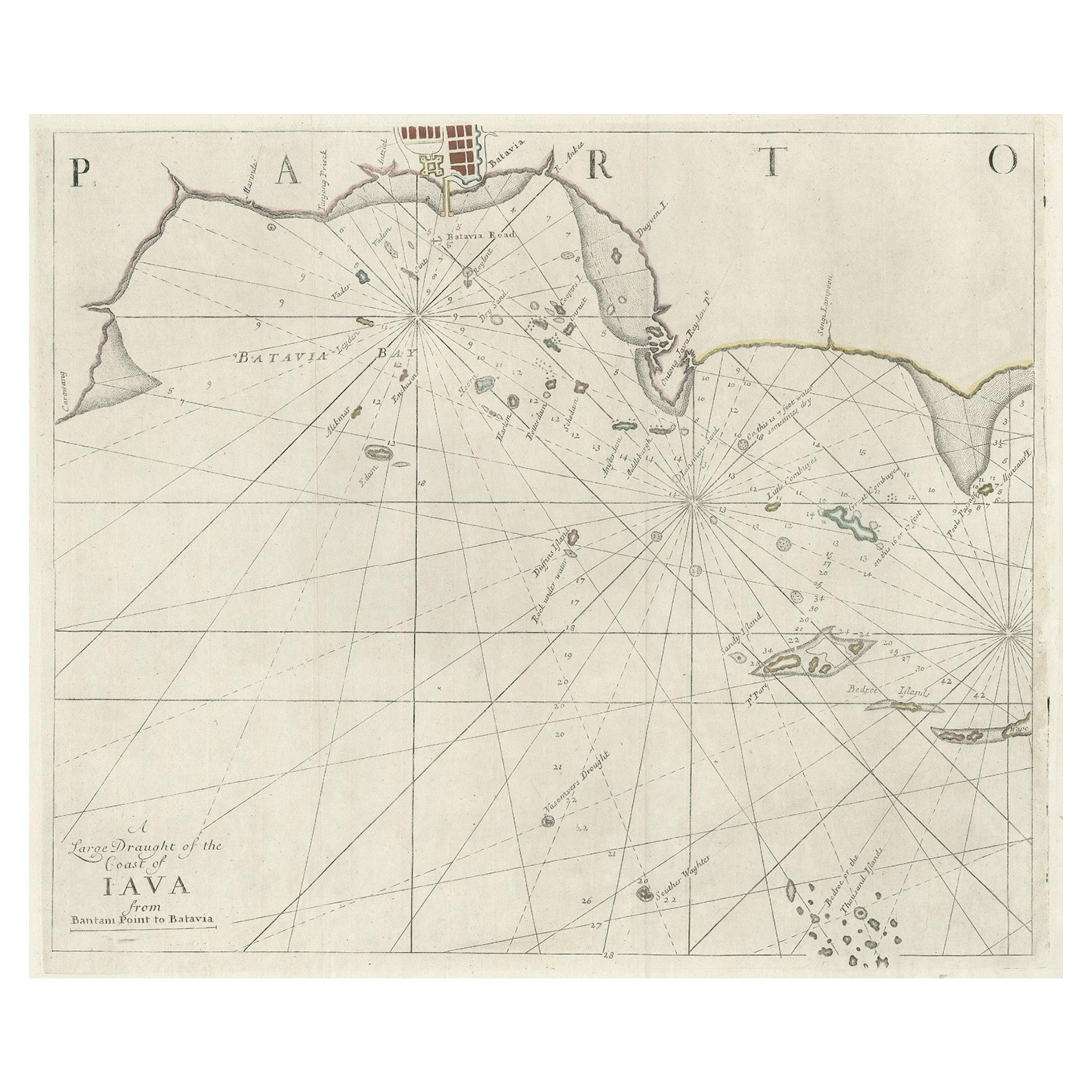
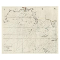
View AllTwo Antique Sea Charts of the Thousand Islands between Batavia and Bantam, c1734
Located in Langweer, NL
Antique maps titled 'A large draught of the Coast of Iava from Bantam Point to Batavia'. Two seperate sheets, joined together they depict the island of Java, Indonesia.
Condition...
Category
Antique 1730s Maps
Materials
Paper
$1,530 Sale Price / set
20% Off
Antique Sea Chart of North America by Ottens, circa 1745
Located in Langweer, NL
Antique map titled 'Septemtrionaliora Americae a Groenlandia (..)'. Sea chart of the northern waters of North America, including the coast of Labrador and pa...
Category
Antique Mid-18th Century Maps
Materials
Paper

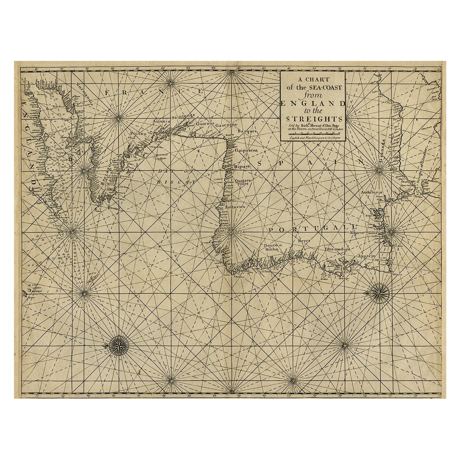
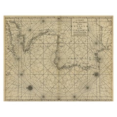
Original Antique Sea Chart of the Coastline from England to Gibraltar, ca.1700
Located in Langweer, NL
Antique map titled 'A Chart of the Sea-Coast from England to the Streights.'
Original antique map showing the European coastline from the South of England (and North of France) to ...
Category
Antique Early 1700s Maps
Materials
Paper
$881 Sale Price
20% Off
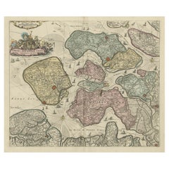
Decorative Antique Sea Chart of Zeeland, a Province of the Netherlands, ca.1730
Located in Langweer, NL
Antique map titled 'Comitatus Zelandiae Tabula emendata a Frederico De Wit'.
Decorative sea chart of Zeeland, a province of the Netherlands. Although the title reads F. de Wit, thi...
Category
Antique 1730s Maps
Materials
Paper
$1,066 Sale Price
20% Off
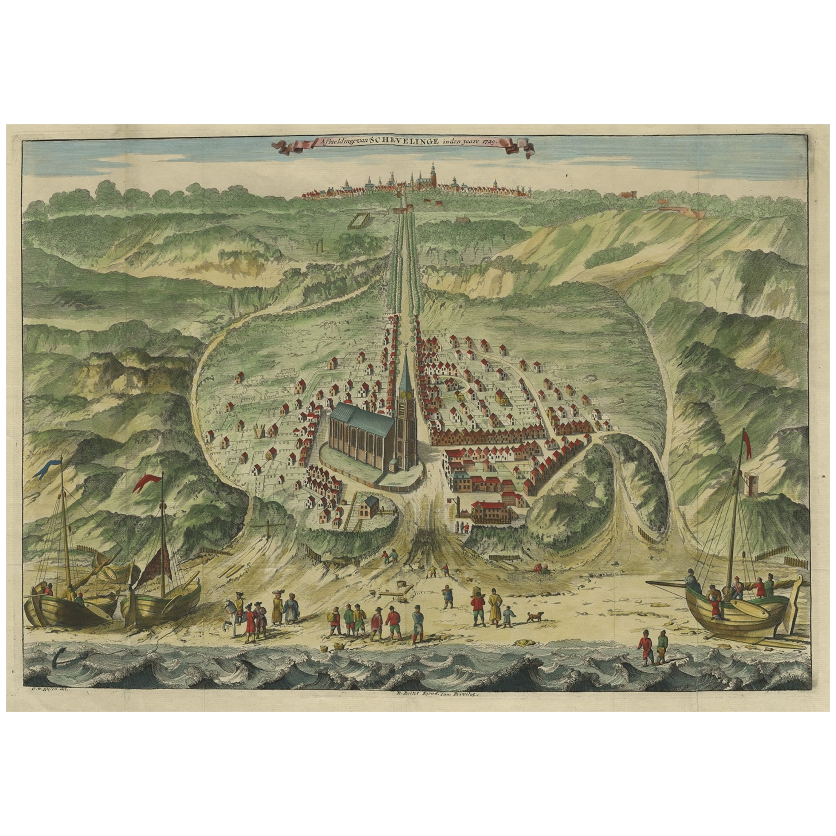
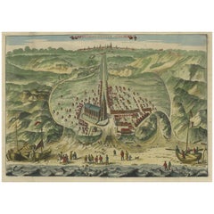
Antique Bird's Eye View of Scheveningen Near The Hague, the Netherlands, 1730
Located in Langweer, NL
Antique print titled 'Afbeeldinge van Schevelinge in den Jaare 1729'.
Bird's eye view of Scheveningen near The Hague / Den Haag, the Netherlands. This print originates from 'Beschr...
Category
Antique 1730s Maps
Materials
Paper
$1,246 Sale Price
20% Off
Beautiful Antique Map of the Province of Noord-Holland, the Netherlands, Ca.1730
Located in Langweer, NL
Antique map titled 'Kennemaria et Westfrisia vulgo et vernaculé Noord-Holland'.
Beautiful original antique map of the province of Noord-Holland, the Netherlands. Two large elaborat...
Category
Antique 1730s Maps
Materials
Paper
$1,345 Sale Price
20% Off
You May Also Like
Antique Anatomical Wall Chart Depicting the Human Skeleton
Located in Berghuelen, DE
A rare 19th century anatomical wall chart depicting the human skeleton. On the sides On the sides are detailed description in German language. The wall...
Category
Early 20th Century German Victorian Prints
Materials
Paper

Chart of the East Coast of England
Located in Norwell, MA
Chart of the East Coast of England, from Dungeness to Flamborough, including the entrances to the Thames River. Drawn by hydrographer J.W. Norie in 1841. Includes Kent, Essex and Suf...
Category
Antique 1840s English Nautical Objects
Materials
Paper

Anatomical Wall Chart Depicting the Human Lymphatic and Blood Vessels
Located in Berghuelen, DE
A rare 19-carat anatomical wall chart depicting the human lymphatic and blood vessels. On the sides with detailed description in German language. Print...
Category
Early 20th Century German Victorian Prints
Materials
Paper

Antique Foldable Anatomical Wall Chart Depicting Human Musculature
Located in Berghuelen, DE
Antique Foldable Anatomical Wall Chart Depicting Human Musculature
The rare 19th century anatomical wall chart depicts the human musculature and inter...
Category
Early 20th Century German Victorian Prints
Materials
Wood, Paper

New Map of North America from the Latest Discoveries, 1763
Located in Philadelphia, PA
A fine antique 18th century map of the North American seaboard.
Entitled "A New Map of North America from the Latest Discoveries 1763".
By the Cartographer/Engraver - John Spil...
Category
Antique Mid-18th Century English Georgian Maps
Materials
Paper

“A Football Match, Scotland v. England” Antique Engraving, Proof Edition of 100
By Overend and Smythe
Located in Colorado Springs, CO
This is the 1889 William H. Overend (1851-1898) and Lionel Smythe (1839-1918) first edition, photogravure of the Calcutta Cup – a Rugby match between Scotland and England, that has been played over 100 times, the first match...
Category
Antique 19th Century English Prints
Materials
Paper
