Items Similar to Antique Map of the 1591 Siege and Occupation of Deventer City, Holland, c1610

Want more images or videos?
Request additional images or videos from the seller
1 of 6
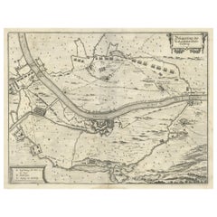
Antique Map of the 1591 Siege and Occupation of Deventer City, Holland, c1610
About the Item
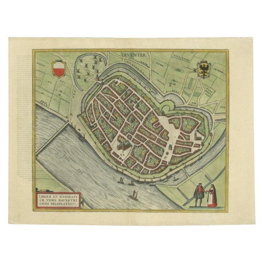
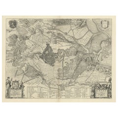
Antique map titled 'Daventria'. Old map of the city of Deventer, the Netherlands. The print illustrates the siege and occupation of Deventer by the State army under command of prince Maurits on 10 June 1591. It shows the city of Deventer and the surrounding land with walls and ramparts. With two pontoon bridges over the IJssel river. This map originates from 'Den Nassauschen Lauren-Crans: Beschrijvinghe ende af-beeldinge van alle de victorien' by Jan Jansz. Orlers en Hendrik van Haestens.
Artists and Engravers: Jan Janszoon Orlers (1570 - 1646), Dutch historian.
Condition: Good, general age-related toning. Some soiling, please study image carefully.
Date: 1610
Overall size: 37.5 x 31 cm.
Image size: 31 x 22 cm.
- Dimensions:Height: 12.21 in (31 cm)Width: 14.77 in (37.5 cm)Depth: 0 in (0.01 mm)
- Materials and Techniques:
- Period:
- Date of Manufacture:1610
- Condition:
- Seller Location:Langweer, NL
- Reference Number:
About the Seller
5.0
Platinum Seller
These expertly vetted sellers are 1stDibs' most experienced sellers and are rated highest by our customers.
Established in 2009
1stDibs seller since 2017
1,932 sales on 1stDibs
Typical response time: <1 hour
- ShippingRetrieving quote...Ships From: Langweer, Netherlands
- Return PolicyA return for this item may be initiated within 14 days of delivery.
More From This SellerView All
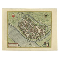
- Antique Original Map of the City of Deventer, the Netherlands, 1588Located in Langweer, NLAntique map titled 'Liberae et Hanseaticae urbis Daventriensis delineatio'. Original bird's eye plan of the Dutch hanseatic city Deventer, on the situated IJssel river. This map ...Category
Antique 16th Century Maps
MaterialsPaper
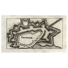
- Antique Map of Deventer in the Netherlands, 1691Located in Langweer, NLPlate 'Devendr.' (Plan of the fortified city of Deventer, The Netherlands.) This attractive original old antique print / plate originates from: 'Aus...Category
Antique 17th Century Maps
MaterialsPaper
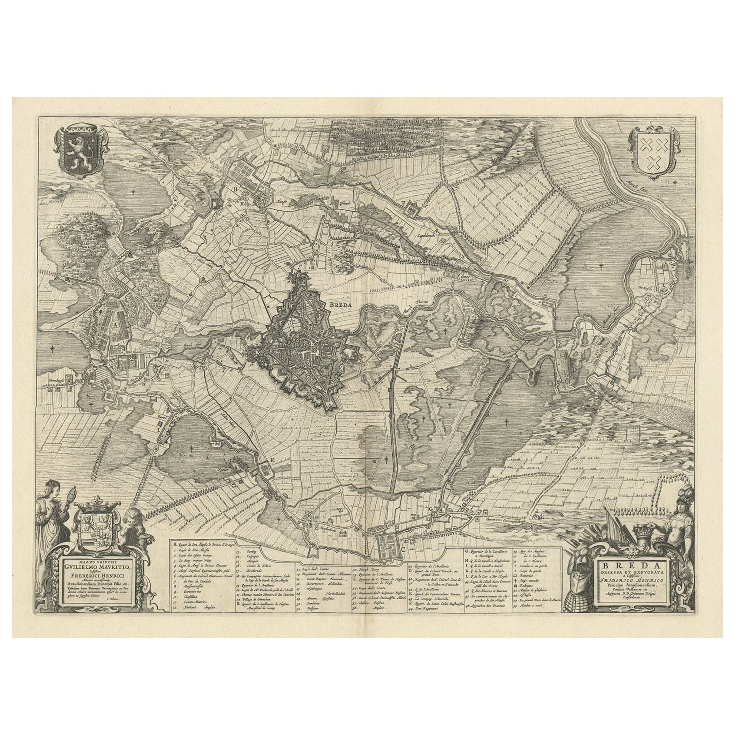
- Antique Map of the Siege of Breda, City in the Netherlands by Blaeu, 1649Located in Langweer, NLAntique map titled 'Breda obsessa et expugnata a Celsissimo Frederico Henrico'. Old map of the city of Breda, the Netherlands. It shows the Siege of Breda in 1637. Originates fro...Category
Antique 17th Century Maps
MaterialsPaper
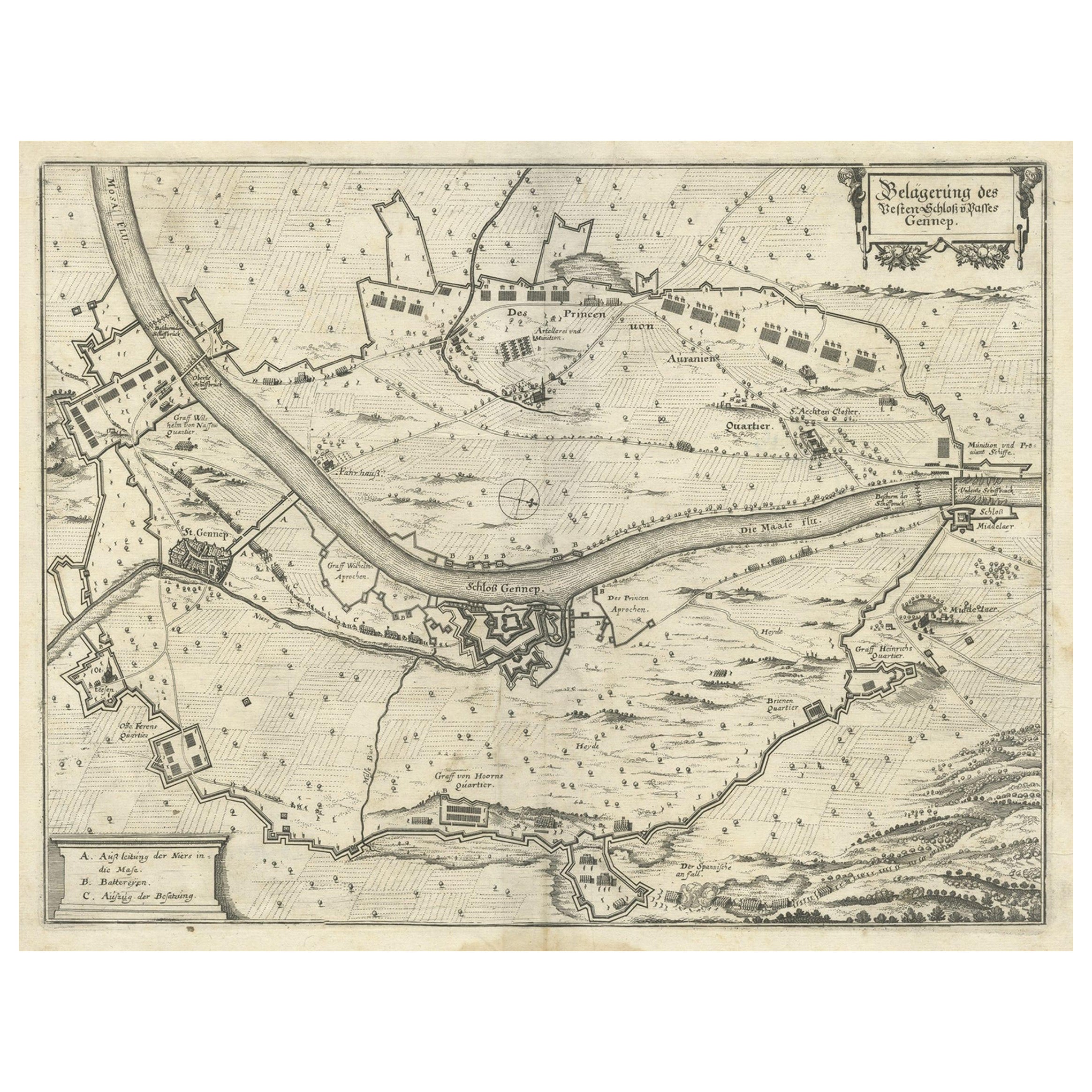
- Antique Map of The Siege of Gennep, the Netherlands, c.1650Located in Langweer, NLAntique map titled 'Belagerung des Besten Schloss und Passes Gennep'. Old map of the Siege of Gennep, the Netherlands. This map originates from 'Theatrum Europaeum' by M. Merian. Art...Category
Antique 17th Century Maps
MaterialsPaper
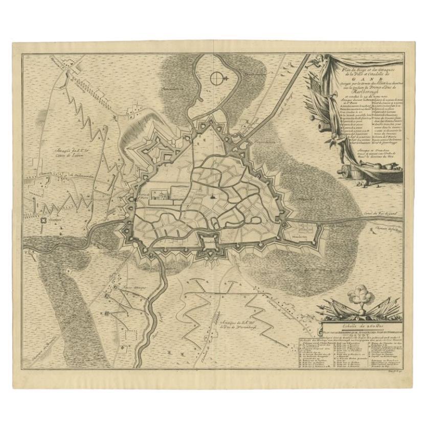
- Antique Map of the Siege of Gent by Dumont, 1729By DumontLocated in Langweer, NLAntique map titled 'Plan of the Siege and Attacks of the City and Citadel of Ghent'. Large map depicting the siege of the Belgian city of Gent in 1708 during the war of the Spanish S...Category
Antique 18th Century Maps
MaterialsPaper
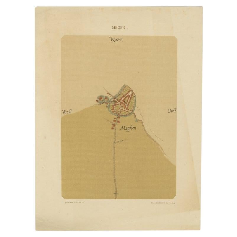
- Old Map of the Dutch City of Megen in Holland, 1916Located in Langweer, NLAntique map Megen titled 'Megen'. Antique map depicting the city of Megen, Noord-Brabant, The Netherlands. Artists and Engravers: Lithograph by J. Smulders & Co, Den Haag. Con...Category
20th Century Maps
MaterialsPaper

You May Also Like
- 17th Century John Speed Map of Denbighshire, c.1610By John SpeedLocated in Royal Tunbridge Wells, KentAntique early 17th century British very rare and original John Speed, hand coloured map of Denbighshire, dated 1610, by John Sunbury and George Humble. John...Category
Antique 17th Century British Maps
MaterialsWood, Paper
- Italian Parchment Map of the City of Pisa Dated, 1640By Matthäus Merian the ElderLocated in Roma, ITAn antique map of the Tuscan city of Pisa engraved for The 'Itinerarium Italiæ Nov-antiquæ' by Matthäus Merian the Elder and printed in 1640....Category
Antique 1640s Italian Maps
MaterialsPaper
- Italian Parchment Map of the City of Lucca Dated 1640By Matthäus Merian the ElderLocated in Roma, ITAn antique map of the Tuscan city of Lucca engraved for The 'Itinerarium Italiæ Nov-antiquæ' by Matthäus Merian the Elder and printed in 1640...Category
Antique 1640s Italian Maps
MaterialsParchment Paper, Paper
- 1840 Map of the City of Washington Published by William M. MorrisonLocated in Colorado Springs, COThis map, printed in 1840, is a detailed representation of Washington, D.C. in the mid-19th century. The map shows block numbers, wards, and government buildings as well as details o...Category
Antique 1840s American Federal Maps
MaterialsPaper
- 1861 Topographical Map of the District of Columbia, by Boschke, Antique MapLocated in Colorado Springs, COPresented is an original map of Albert Boschke's extremely sought-after "Topographical Map of the District of Columbia Surveyed in the Years 1856 ...Category
Antique 1860s American Historical Memorabilia
MaterialsPaper
- Dutch Map and City Plan of La Roche-sur-Foron, France, 17th Century Hand ColoredBy Coenraet DeckerLocated in Alamo, CA"Rupes Allobrogum vulgo La Roche" by Dutch engraver Coenraet Decker (1650-1685) is from the atlas Theatrum Statuum Regiae Celestudinis Sabaudiae Ducis, published in 1682. This richly...Category
Antique Late 17th Century Dutch Maps
MaterialsPaper


Recently Viewed
View AllMore Ways To Browse
Map Wall
Antique Prince And
Antique Wall Map
Antique Wall Maps
Antique 17th Century Dutch
Siege Of
Antique State Maps
Prince Dutch
Siege Antique
Jan Hendrik
Used Pontoons
Antique Furniture Long Island
London Antique Map
London Map Antique
Antique Maps London
Antique London Maps
Antique London Map
London Antique Maps