Items Similar to Antique Map of Asia by Sanson, circa 1705


Want more images or videos?
Request additional images or videos from the seller
1 of 10
Antique Map of Asia by Sanson, circa 1705
$382.19
$477.7420% Off
£283.20
£35420% Off
€320
€40020% Off
CA$528.70
CA$660.8820% Off
A$582.67
A$728.3320% Off
CHF 305.05
CHF 381.3120% Off
MX$7,156.99
MX$8,946.2320% Off
NOK 3,832.96
NOK 4,791.2020% Off
SEK 3,587.35
SEK 4,484.1820% Off
DKK 2,437.04
DKK 3,046.3020% Off
About the Item
Dutch edition of Sanson's map of Asia. Shows a large, dramatic version of Terre de Jesso, drawn from the discoveries of the Maarten de Vries expedition of 1643.
- Creator:Nicolas Sanson (Artist)
- Dimensions:Height: 10.04 in (25.5 cm)Width: 16.15 in (41 cm)Depth: 0.02 in (0.5 mm)
- Materials and Techniques:
- Place of Origin:
- Period:
- Date of Manufacture:circa 1705
- Condition:General age-related toning. Some marginal tears, please study image carefully.
- Seller Location:Langweer, NL
- Reference Number:Seller: BG-099821stDibs: LU3054313306782
About the Seller
5.0
Recognized Seller
These prestigious sellers are industry leaders and represent the highest echelon for item quality and design.
Platinum Seller
Premium sellers with a 4.7+ rating and 24-hour response times
Established in 2009
1stDibs seller since 2017
2,618 sales on 1stDibs
Typical response time: <1 hour
- ShippingRetrieving quote...Shipping from: Langweer, Netherlands
- Return Policy
Authenticity Guarantee
In the unlikely event there’s an issue with an item’s authenticity, contact us within 1 year for a full refund. DetailsMoney-Back Guarantee
If your item is not as described, is damaged in transit, or does not arrive, contact us within 7 days for a full refund. Details24-Hour Cancellation
You have a 24-hour grace period in which to reconsider your purchase, with no questions asked.Vetted Professional Sellers
Our world-class sellers must adhere to strict standards for service and quality, maintaining the integrity of our listings.Price-Match Guarantee
If you find that a seller listed the same item for a lower price elsewhere, we’ll match it.Trusted Global Delivery
Our best-in-class carrier network provides specialized shipping options worldwide, including custom delivery.More From This Seller
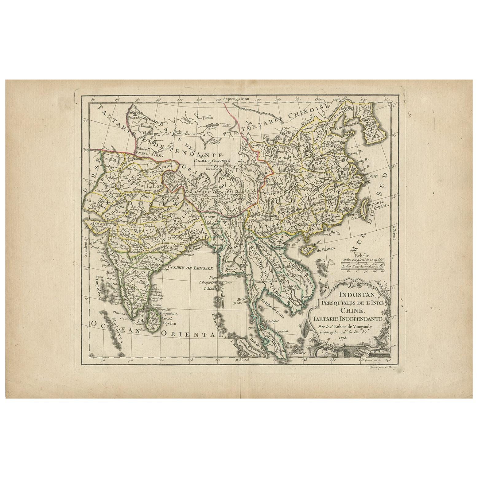
View AllAntique Map of Asia by Dussy, 1778
Located in Langweer, NL
Antique map of Asia titled 'Indostan presqu'isles de l'Inde, Chine, Tartarie Independante'. Depicting South-East Asia including Hindustan, India an...
Category
Antique Late 18th Century French Maps
Materials
Paper
$210 Sale Price
20% Off
Antique Map of Southeast Asia by Van Dùren, 1752
Located in Langweer, NL
Antique map titled 'Neue Vorstellung von Indien und China'. Original antique map of Southeast Asia. This map originates from 'Neue Sammlung der merkwürdigsten Reisegeschichten, inson...
Category
Antique Mid-18th Century Maps
Materials
Paper

$429 Sale Price
20% Off
Antique Map of Asia by Guthrie, 1787
Located in Langweer, NL
Antique map titled 'Asia from the best Authorities'. Old map of the Asian continent. This map originates from 'A New Geographical, Historical and Commercial Grammar; and Present State of the several Kingdoms of the World' 10th ed. by W. Guthrie.
Artists and Engravers: Published by Ch.Dilly; GGJ...
Category
Antique 18th Century Maps
Materials
Paper

$138 Sale Price
20% Off
Antique Map of Asia by Tirion 'c.1760'
Located in Langweer, NL
Antique map titled 'Nuova Carta dell Asia'. Decorative map of Asia. Published by I. Tirion, circa 1760.
Category
Antique Mid-18th Century Maps
Materials
Paper

$1,051 Sale Price
20% Off
Antique Map of Asia by A. Blondeau, circa 1800
Located in Langweer, NL
This is a fine circa 1800 map of Asia by Alexandre Blondeau. It covers the entire continent from Africa and the Mediterranean east to the Bering Sea and south as far as Java and New ...
Category
Antique Early 19th Century Maps
Materials
Paper

$267 Sale Price
20% Off
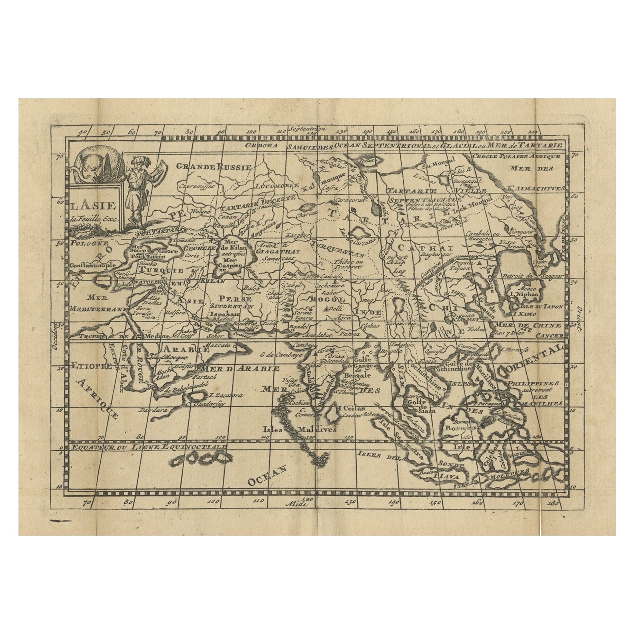
Antique Map of Asia with Misshaped Coastlines and Distorted Islands c.1760
Located in Langweer, NL
Antique map titled 'L’Asie la feuille exc'. Old map of Asia. The map contains several misshaped coastlines and distorted islands with a small cartouche held by an elephant in the top...
Category
Antique 18th Century Maps
Materials
Paper
$132 Sale Price
20% Off
You May Also Like
Antique 1803 Italian Map of Asia Including China Indoneseia India
Located in Amsterdam, Noord Holland
Antique 1803 Italian Map of Asia Including China Indoneseia India
Very nice map of Asia. 1803.
Additional information:
Type: Map
Country of Manufacturing: Europe
Period: 19th centu...
Category
Antique 19th Century European Maps
Materials
Paper

$584 Sale Price
20% Off
Antique French Map of Asia Including China Indoneseia India, 1783
Located in Amsterdam, Noord Holland
Very nice map of Asia. 1783 Dedie au Roy.
Additional information:
Country of Manufacturing: Europe
Period: 18th century Qing (1661 - 1912)
Condition: Overall Condition B (Good Used)...
Category
Antique 18th Century European Maps
Materials
Paper

$648 Sale Price
20% Off
Original Antique Map of South East Asia by Thomas Clerk, 1817
Located in St Annes, Lancashire
Great map of South East Asia
Copper-plate engraving
Drawn and engraved by Thomas Clerk, Edinburgh.
Published by Mackenzie And Dent, 1817
Unframed.
Category
Antique 1810s English Maps
Materials
Paper

Super Rare Antique French Map of Chine and the Chinese Empire, 1780
Located in Amsterdam, Noord Holland
Super Rare Antique French Map of Chine and the Chinese Empire, 1780
Very nice map of Asia. 1780 Made by Bonne.
Additional information:
Type: Map
...
Category
Antique 18th Century European Maps
Materials
Paper

$584 Sale Price
33% Off
Large Original Antique Map of Asia by Sidney Hall, 1847
Located in St Annes, Lancashire
Great map of Asia
Drawn and engraved by Sidney Hall
Steel engraving
Original colour outline
Published by A & C Black. 1847
Unframed
Free shipping
Category
Antique 1840s Scottish Maps
Materials
Paper

Map of the East Indies: An Original 18th Century Hand-colored Map by E. Bowen
Located in Alamo, CA
This is an original 18th century hand-colored map entitled "An Accurate Map of the East Indies Exhibiting the Course of the European Trade both on the Continent and Islands" by Emanu...
Category
Mid-18th Century Old Masters Landscape Prints
Materials
Engraving

More Ways To Browse
Antique Map Of England
Antique Maps Framed
United States Map
Europe Map Antique
Indonesia Map
Antique Maps Of Germany
Map Of Japan
Military Map
Antique World Maps
Antique Maps Of Holland
Compass Rose Antique
Antique Furniture Portugal
Antique Maps Of Europe
Map Greece
Maps Of Mediterranean
Mississippi Antique
Large Framed Maps
Antique Furniture Plans