Items Similar to Antique Map of the Banda Islands by Commelin, 1646


Want more images or videos?
Request additional images or videos from the seller
1 of 5
Antique Map of the Banda Islands by Commelin, 1646
$337.64
$422.0520% Off
£249.96
£312.4520% Off
€282.40
€35320% Off
CA$467.21
CA$584.0120% Off
A$515.09
A$643.8620% Off
CHF 269.48
CHF 336.8520% Off
MX$6,319.20
MX$7,89920% Off
NOK 3,392.20
NOK 4,240.2520% Off
SEK 3,172.25
SEK 3,965.3120% Off
DKK 2,151.15
DKK 2,688.9420% Off
About the Item
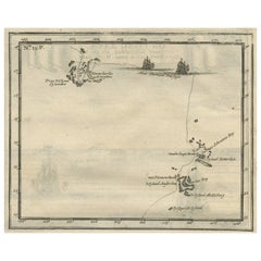
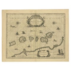
Plate 15: 'Afteeckeninge van 't Eyland Banda.' Depiction of the Banda Islands, Indonesia. Rare. This attrative plate originates from: 'Title: Waerachtigh verhael van de Schipvaerd op Oost-Indien Ghedaen by de acht Schepen in den jare 1598. van Amsterdam uyt-gezeylt, onder 't beleyd van den Admirael Jacob Cornelissoon van Neck, ende Vice-Admirael Wybrand van Warwijck..', which was part of the monumental work by Isaac Commelin (1598-1676) on VOC voyages: 'Begin ende voortgangh van de Vereenighde Nederlantsche Geoctroyeerde Oost-Indische Companie....', published by Joannes Janssonius, Amsterdam, 1646. Jacob Corneliszoon van Neck (1564-1638) was a Dutch naval officer and explorer, who led the second Dutch expedition to Indonesia (1598-99). The purpose of the expedition was to bring back spices, and was a huge success. Van Neck returned to Indonesia once more, but on that journey lost three fingers during a battle with a Spanish-Portuguese fleet. This prompted him to retire from exploration and travel. He later became mayor of Amsterdam, alderman and member of two admiralty colleges. (Ref: *Tiele 81; *Landwehr, VOC, 250.) Artists and Engravers: Casparus Commelin (1636-1693), publisher and bookseller in Amsterdam. Engraver/etcher unknown.
Artist: Casparus Commelin (1636-1693), publisher and bookseller in Amsterdam. Engraver/etcher unknown.
Condition: Good, given age. General age related toning and light staining. Please study scan carefully.
Date: 1646
Overall size: 23 x 17.5 cm.
Image size: 0.001 x 20 x 14 cm.
Antique prints have long been appreciated for both their aesthetic and investment value. They were the product of engraved, etched or lithographed plates. These plates were handmade out of wood or metal, which required an incredible level of skill, patience and craftsmanship. Whether you have a house with Victorian furniture or more contemporary decor an old engraving can enhance your living space. We offer a wide range of authentic antique prints for any budget.
- Dimensions:Height: 6.89 in (17.5 cm)Width: 9.06 in (23 cm)Depth: 0 in (0.01 mm)
- Materials and Techniques:
- Period:
- Date of Manufacture:1646
- Condition:
- Seller Location:Langweer, NL
- Reference Number:Seller: PCT-364601stDibs: LU3054327773802
About the Seller
5.0
Recognized Seller
These prestigious sellers are industry leaders and represent the highest echelon for item quality and design.
Platinum Seller
Premium sellers with a 4.7+ rating and 24-hour response times
Established in 2009
1stDibs seller since 2017
2,609 sales on 1stDibs
Typical response time: <1 hour
- ShippingRetrieving quote...Shipping from: Langweer, Netherlands
- Return Policy
Authenticity Guarantee
In the unlikely event there’s an issue with an item’s authenticity, contact us within 1 year for a full refund. DetailsMoney-Back Guarantee
If your item is not as described, is damaged in transit, or does not arrive, contact us within 7 days for a full refund. Details24-Hour Cancellation
You have a 24-hour grace period in which to reconsider your purchase, with no questions asked.Vetted Professional Sellers
Our world-class sellers must adhere to strict standards for service and quality, maintaining the integrity of our listings.Price-Match Guarantee
If you find that a seller listed the same item for a lower price elsewhere, we’ll match it.Trusted Global Delivery
Our best-in-class carrier network provides specialized shipping options worldwide, including custom delivery.More From This Seller
View AllAntique Map of the Maluku Islands by Blaeu, c.1640
Located in Langweer, NL
Antique map titled 'Moluccae Insulae Celeberrimae'. Decorative map of the Maluku Islands, also known as the Moluccas or the Spice Islands. Inset of the island of Bachian (Batjan) in ...
Category
Antique 17th Century Maps
Materials
Paper

$1,291 Sale Price
20% Off
Antique Map of the Maluku Islands by Van der Aa, 1714
By Pieter Van Der Aa
Located in Langweer, NL
Antique Map Moluccas titled 'Les Isles Moluques'. Rare map of the Spice Islands made after a map engraved by Pieter van den Keere and published in the 1628 edition of the Mercator At...
Category
Antique 18th Century Maps
Materials
Paper

$190 Sale Price
20% Off
Antique Map of the Island Java, Indonesia, c.1650
Located in Langweer, NL
Antique map titled 'Insulae Iavae cum parte insularum Boreno Sumatrae (..)'.
Beautiful map of the island of Java and part of Borneo, Bali, Madura and Sumatra. With decorative carto...
Category
Antique 17th Century Maps
Materials
Paper

$3,108 Sale Price
20% Off
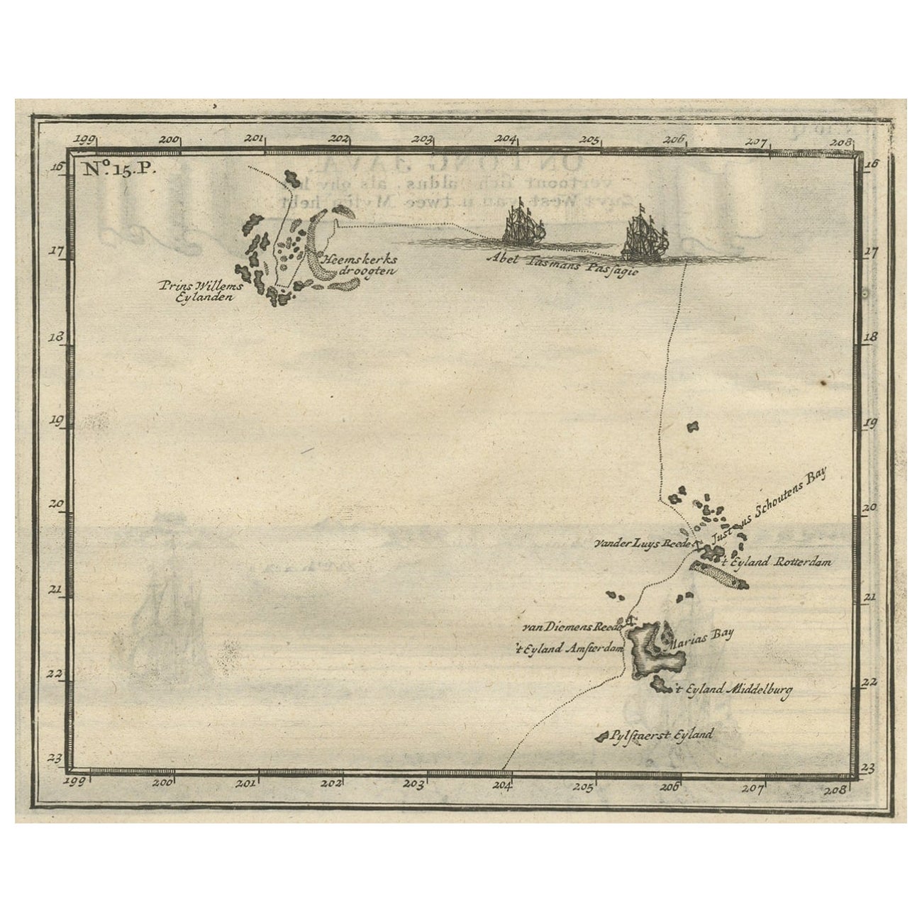
Antique Map of the Banda Islands and the Route of Abel Tasman, Indonesia, 1726
Located in Langweer, NL
Antique print Indonesia with an image on each side. The first image depicts Ontong Java, one of the largest atolls on earth. On verso: antique map of the Banda Islands. With the rout...
Category
Antique 1720s Maps
Materials
Paper
$404 Sale Price
24% Off
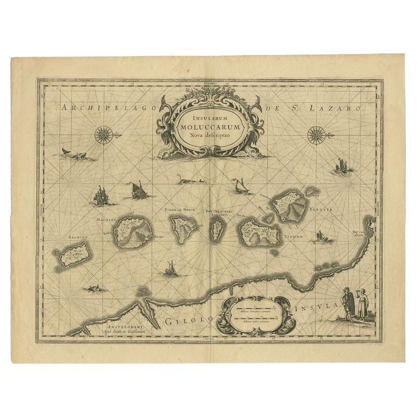
Antique Map of the Moluccas in Indonesia by Janssonius, C.1650
By Johannes Janssonius
Located in Langweer, NL
Antique map titled 'Insularum Moluccarum Nova Descriptio.' Old map of the Moluccas. The famous Spice Islands, the cornerstone of the Dutch trading ...
Category
Antique 17th Century Maps
Materials
Paper
$535 Sale Price
20% Off
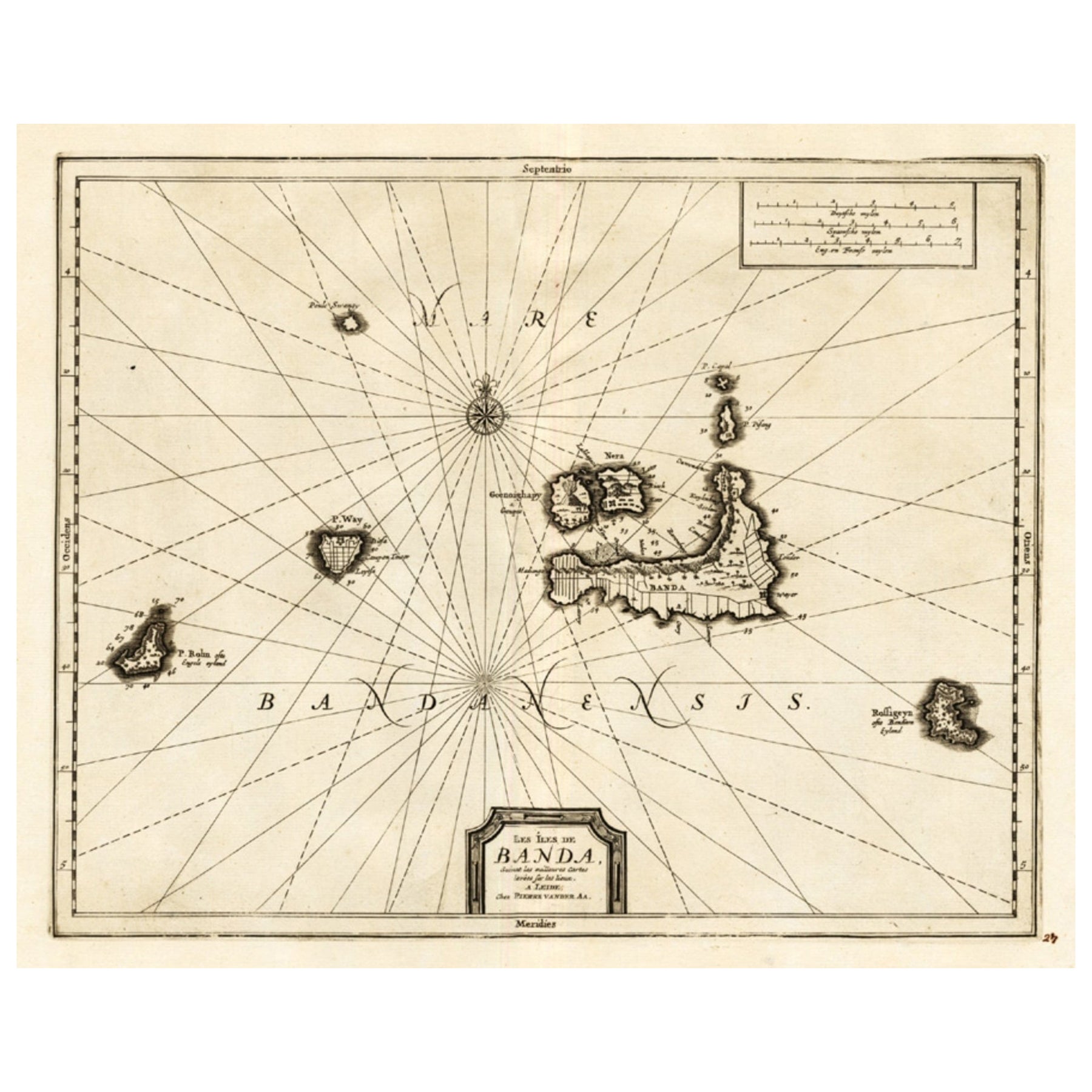
Antique Map of the Islands of Banda, Indonesia from a Very Rare Edition, 1725
Located in Langweer, NL
Antique map titled 'Les Iles de Banda (..).' (The islands of Banda, Indonesia.)
Extremely rare in this edition. This plate originates from the very scarse: 'La galerie agreable d...
Category
Antique 1720s Maps
Materials
Paper

$851 Sale Price
20% Off
You May Also Like
Ancient Map - Zeilan - Etching by Johannes Janssonius - 1650s
By Johannes Janssonius
Located in Roma, IT
Ancient Map - Zeilan is an ancient map realized in 1650 by Johannes Janssonius (1588-1664).
The Map is Hand-colored etching, with coeval watercoloring.
...
Category
1650s Modern Figurative Prints
Materials
Etching

Antique Map - Mare Pacificum - Etching by Johannes Janssonius - 1650s
By Johannes Janssonius
Located in Roma, IT
Mare Pacificum is an antique map realized in 1650 by Johannes Janssonius (1588-1664).
The Map is Hand-colored etching, with coeval watercolorang.
Good conditions with slight foxing...
Category
1650s Modern Figurative Prints
Materials
Etching

Antique Voc Print Holland Malaysia Old Map Melaka History, 1663
Located in Amsterdam, Noord Holland
From my own collection I offer this impressive Antique print of the city of Malakka
A very interesting piece for collectors . It is an museum piece from the Dutch Institute of Orien...
Category
Antique 17th Century European Paintings
Materials
Paper

$293 Sale Price
20% Off
1627 Hendrik Hondius Map Entitled "Vltoniae Orientalis Pars, " Ric.a009
Located in Norton, MA
1627 Hendrik Hondius map entitled
"Vltoniae orientalis pars,"
Ric.a009
Title:
Vltoniae orientalis : pars
Title (alt.) :
Ultoniae orientalis pars
Creator:
Mercator, Gerh...
Category
Antique 17th Century Dutch Maps
Materials
Paper

Rugen Island, Germany: An Early 17th Century Map by Mercator and Hondius
By Gerard Mercator
Located in Alamo, CA
This is an early 17th century map entitled "Nova Famigerabilis Insulae Ac Ducatus Rugiae Desciptio" (Map of Rugen Island, Germany) by Gerard Mercator and Henricus and Joducus Hondiu...
Category
Early 17th Century Old Masters Landscape Prints
Materials
Engraving

Antique Map - Mar Di Athiopia - Etching by Johannes Janssonius - 1650s
By Johannes Janssonius
Located in Roma, IT
Antique Map - Mar Di Athiopia is an antique map realized in 1650 by Johannes Janssonius (1588-1664).
The Map is Hand-colored etching, with coeval watercolorang.
Good conditions wit...
Category
1650s Modern Figurative Prints
Materials
Etching

More Ways To Browse
Long Island Used Furniture
Long Island Artists
Naval Antiques
Old Spice
Antique Map Of Thailand
Map Of Native American Tribes
Marie Galante
Romania Map
Used Furniture Nova Scotia
18th Century Scottish Collectibles
Antique Furniture Northumberland
Antique Map Nova Scotia
Antique Map Palestine
California Island Map
Constantinople Map
Croatian Antiques
Ptolemy Map
Antique Maps Massachusetts