Items Similar to Antique Map Centered on Turkestan
Want more images or videos?
Request additional images or videos from the seller
1 of 6
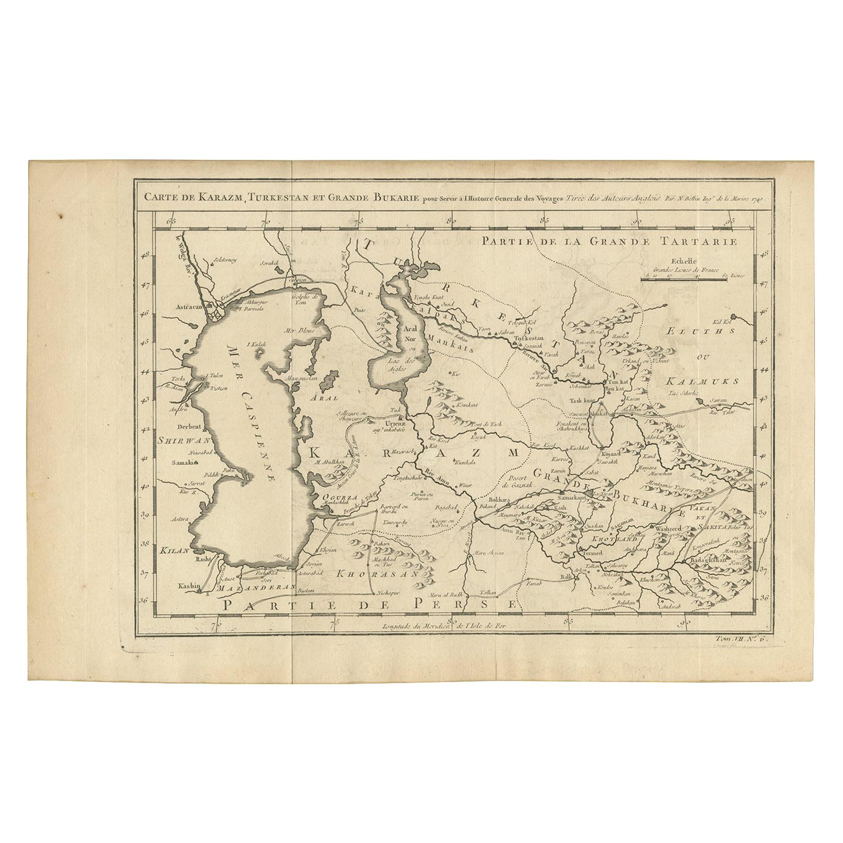
Antique Map Centered on Turkestan
$323.31
$404.1320% Off
£240.76
£300.9520% Off
€272
€34020% Off
CA$446.37
CA$557.9620% Off
A$494.87
A$618.5820% Off
CHF 260.07
CHF 325.0920% Off
MX$6,056.34
MX$7,570.4220% Off
NOK 3,248.02
NOK 4,060.0320% Off
SEK 3,048.59
SEK 3,810.7420% Off
DKK 2,070.92
DKK 2,588.6520% Off
About the Item
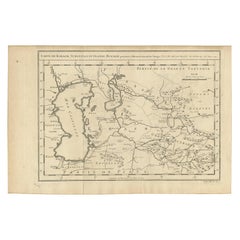
Antique map titled 'Carte de Karazm, Turkestan et Grande Bukarie'. Engraved map centered on Turkestan. Extends to include the Black and Caspian Seas, Uzbekistan, Tajikistan, Turkmenistan, and the northern reaches of Iran and Afghanistan. By Jacques Nicolas Bellin, published 1749.
Jacques Nicolas Bellin (1703 – 21 March 1772) was a French hydrographer, geographer, and member of the French intellectual group called the philosophes.
- Dimensions:Height: 9.53 in (24.2 cm)Width: 12.52 in (31.8 cm)Depth: 0.02 in (0.5 mm)
- Materials and Techniques:
- Period:
- Date of Manufacture:1749
- Condition:General age-related toning. Original folding lines. Narrow right margin, blank verso. Please study image carefully.
- Seller Location:Langweer, NL
- Reference Number:Seller: BG-12707-1091stDibs: LU3054334376632
About the Seller
5.0
Recognized Seller
These prestigious sellers are industry leaders and represent the highest echelon for item quality and design.
Platinum Seller
Premium sellers with a 4.7+ rating and 24-hour response times
Established in 2009
1stDibs seller since 2017
2,609 sales on 1stDibs
Typical response time: <1 hour
- ShippingRetrieving quote...Shipping from: Langweer, Netherlands
- Return Policy
Authenticity Guarantee
In the unlikely event there’s an issue with an item’s authenticity, contact us within 1 year for a full refund. DetailsMoney-Back Guarantee
If your item is not as described, is damaged in transit, or does not arrive, contact us within 7 days for a full refund. Details24-Hour Cancellation
You have a 24-hour grace period in which to reconsider your purchase, with no questions asked.Vetted Professional Sellers
Our world-class sellers must adhere to strict standards for service and quality, maintaining the integrity of our listings.Price-Match Guarantee
If you find that a seller listed the same item for a lower price elsewhere, we’ll match it.Trusted Global Delivery
Our best-in-class carrier network provides specialized shipping options worldwide, including custom delivery.More From This Seller
View AllAntique Map of Khwarezm, Turkestan and Great Bukhara by Bellin, '1749'
Located in Langweer, NL
Antique map titled 'Carte de Karazm, Turkestan, et Grande Bukarie'. Original antique map of Khwarezm, Turkestan and Great Bukhara. Engraved by J.N. Bellin for 'Histoire Générale des ...
Category
Antique Mid-18th Century Maps
Materials
Paper
$190 Sale Price
20% Off
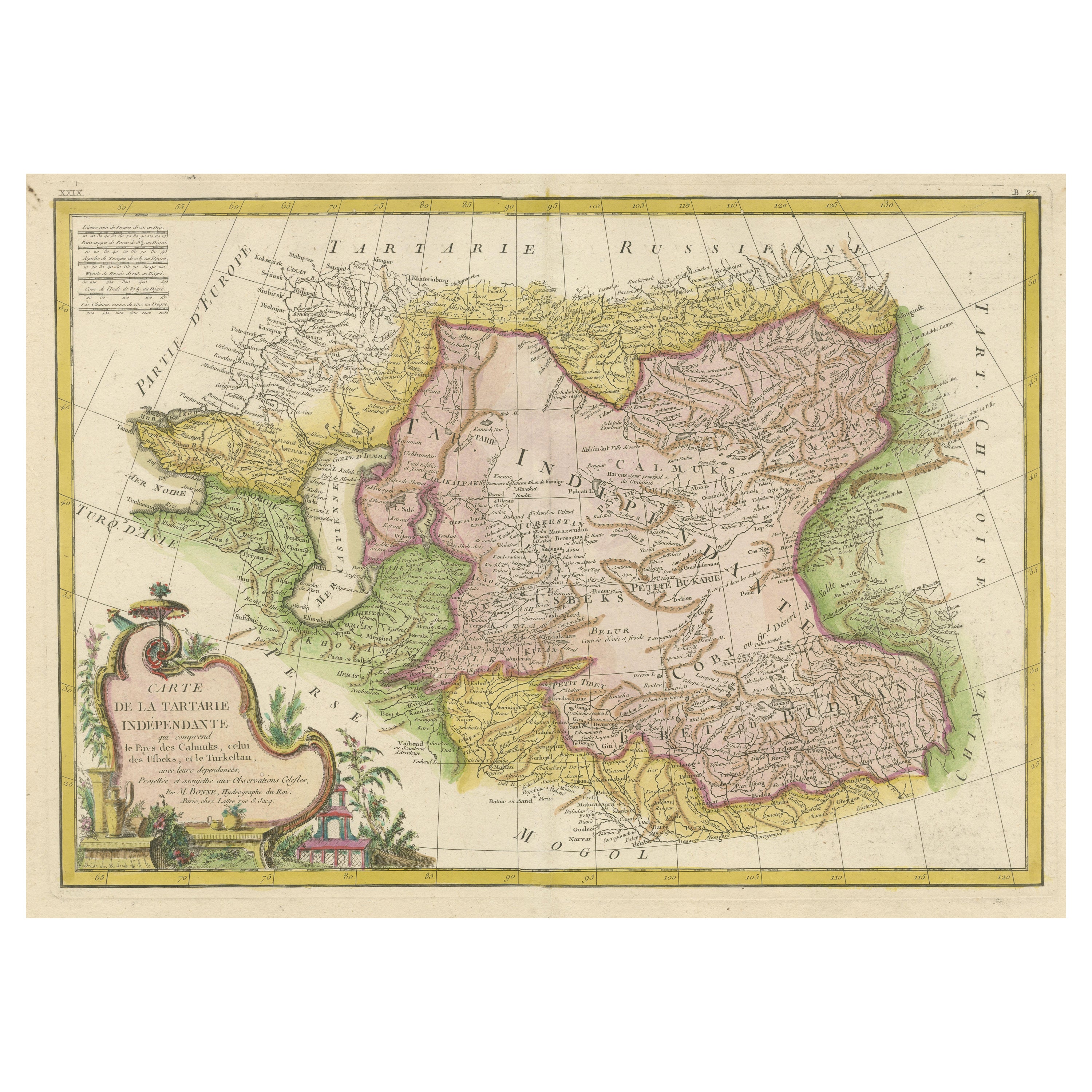
Decorative Antique Map of Central Asia
Located in Langweer, NL
Antique map titled 'Carte de la Tartarie Indépendante (..)'. Decorative map of Central Asia (Tartary). Covers from the Black Sea south to China, north to Russia, and south to Persia ...
Category
Antique Late 18th Century Maps
Materials
Paper
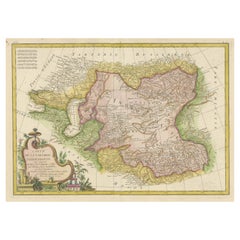
$370 Sale Price
20% Off
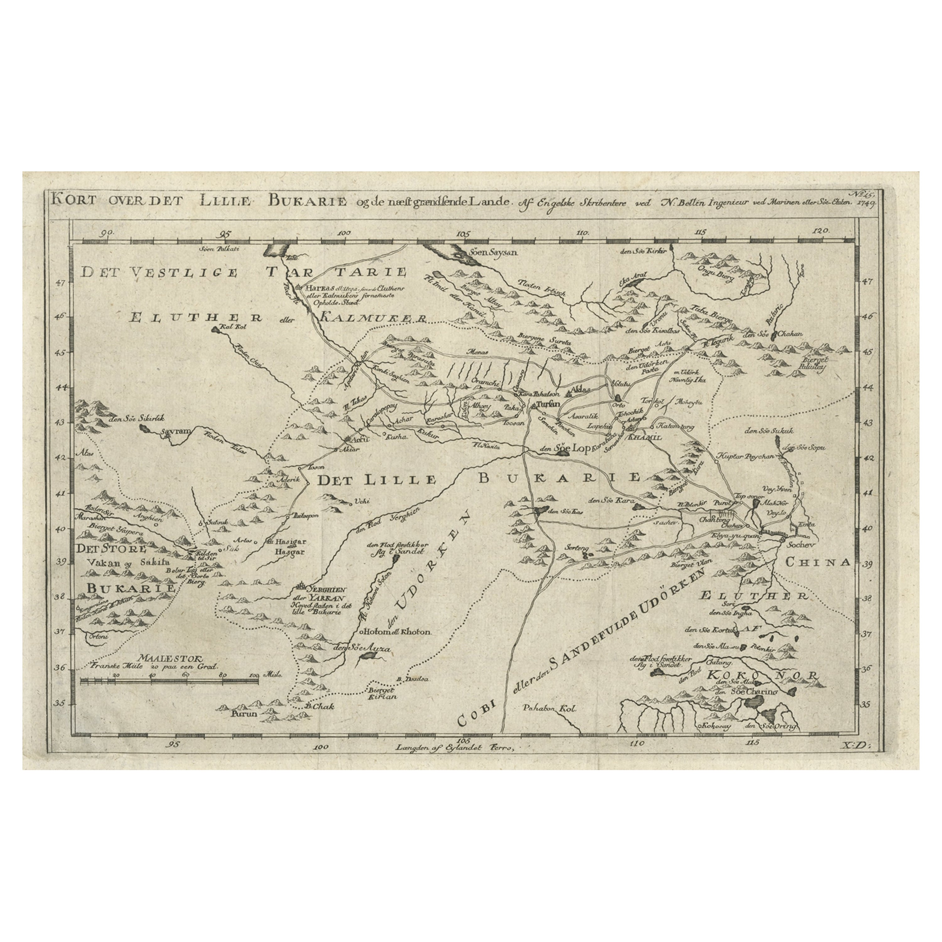
Old Map of Turkmenistan, Uzbekistan, Afghanistan, Tajikistan, Kyrgyzstan, 1757
Located in Langweer, NL
Antique map titled 'Kort over det Lille Bukarie og de naest graensende Lande. af Engelske Skribentere ved N. Bellin Ingenieur ved Marinen efter Söe Etaten'.
Map of present-day Turkmenistan, Uzbekistan, Afghanistan, Tajikistan, Kyrgyzstan including part of China. Originates from 'Almindelig histoirie over reiser til lands og bands (..)'. This 17 volume set is a translation of Collection of voyages and travels edited by Awnsham and John Churchill and Thomas Osborne...
Category
Antique 1750s Maps
Materials
Paper
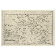
$304 Sale Price
20% Off
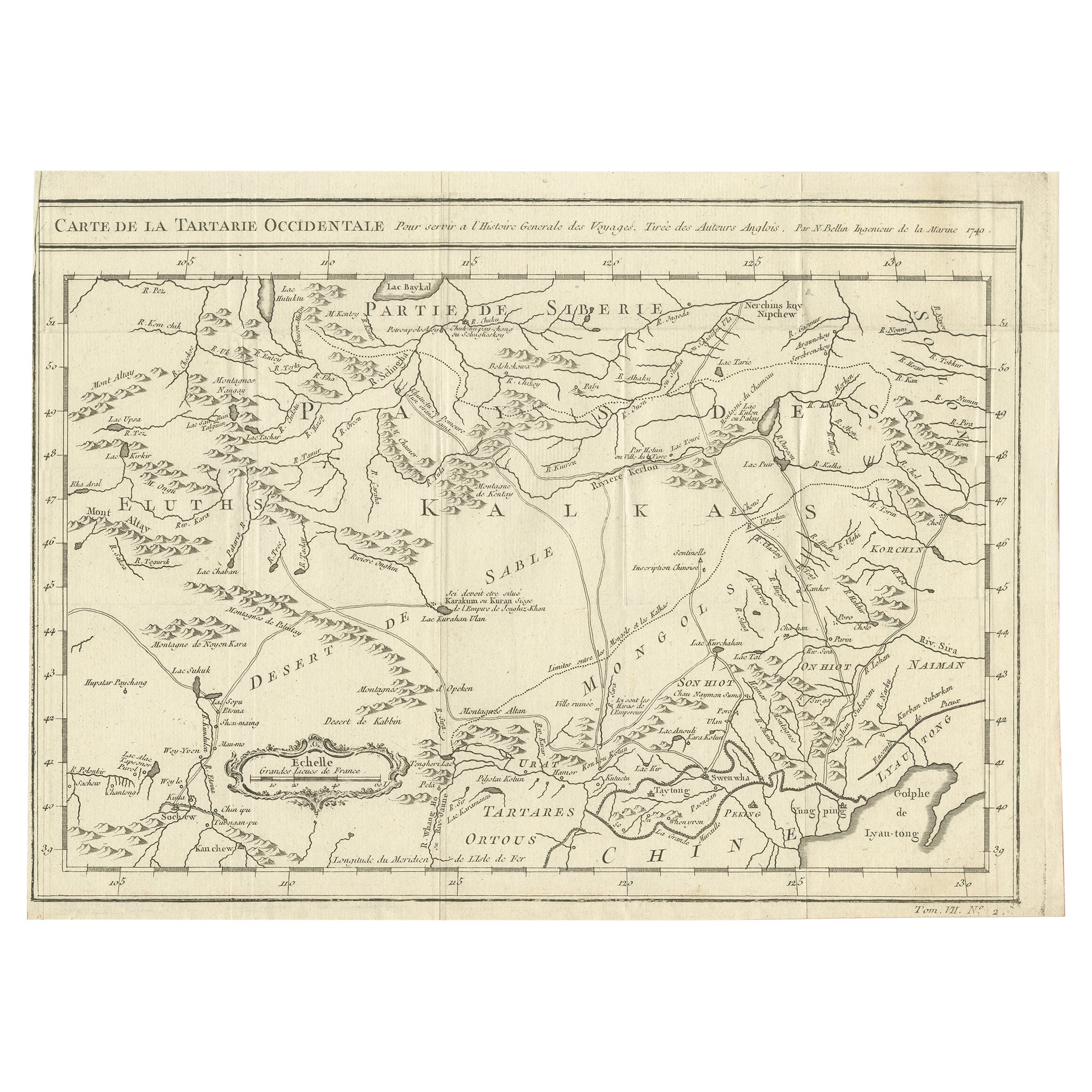
Antique Map of Western Tartary, with Information from Kyrkov's Surveys
Located in Langweer, NL
Antique map titled 'Carte de la Tartarie Occidentale'. This map covers western Tartary with a focus on the region of present-day Mongolia. This map includes information from Kyrkov's...
Category
Antique Mid-18th Century Maps
Materials
Paper
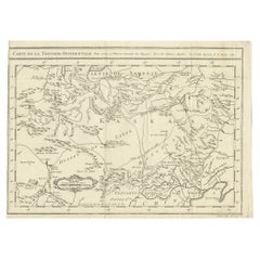
$294 Sale Price
20% Off
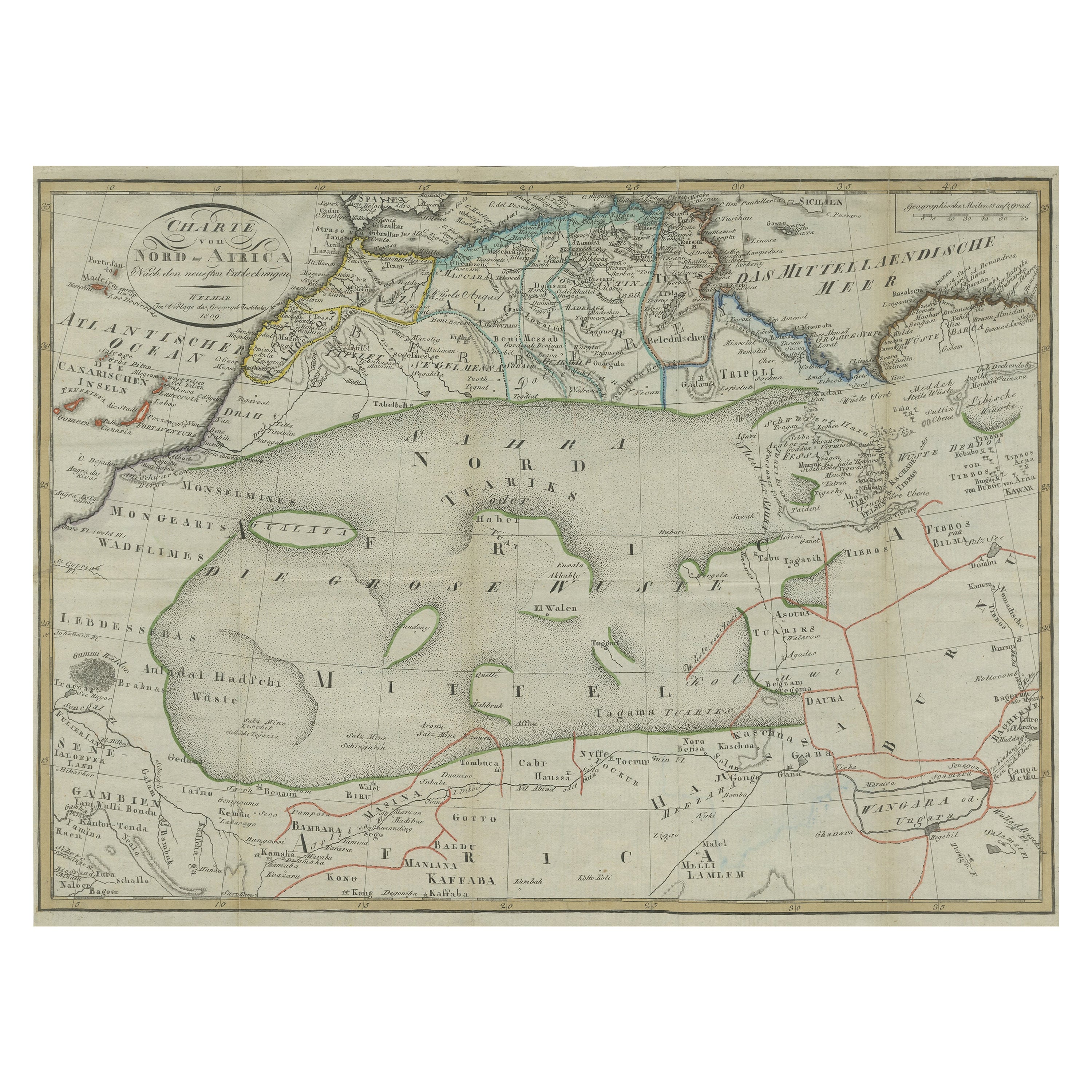
Antique Map of North Africa including the Sahara Desert
Located in Langweer, NL
Antique map titled 'Charte von Nord-Africa'. Scarce map of North Africa. Includes a fantastic depiction of the Sahara Desert. Published in Weimar, 1809.
Category
Antique Early 19th Century Maps
Materials
Paper
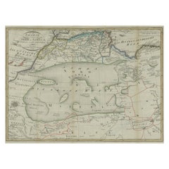
$561 Sale Price
20% Off
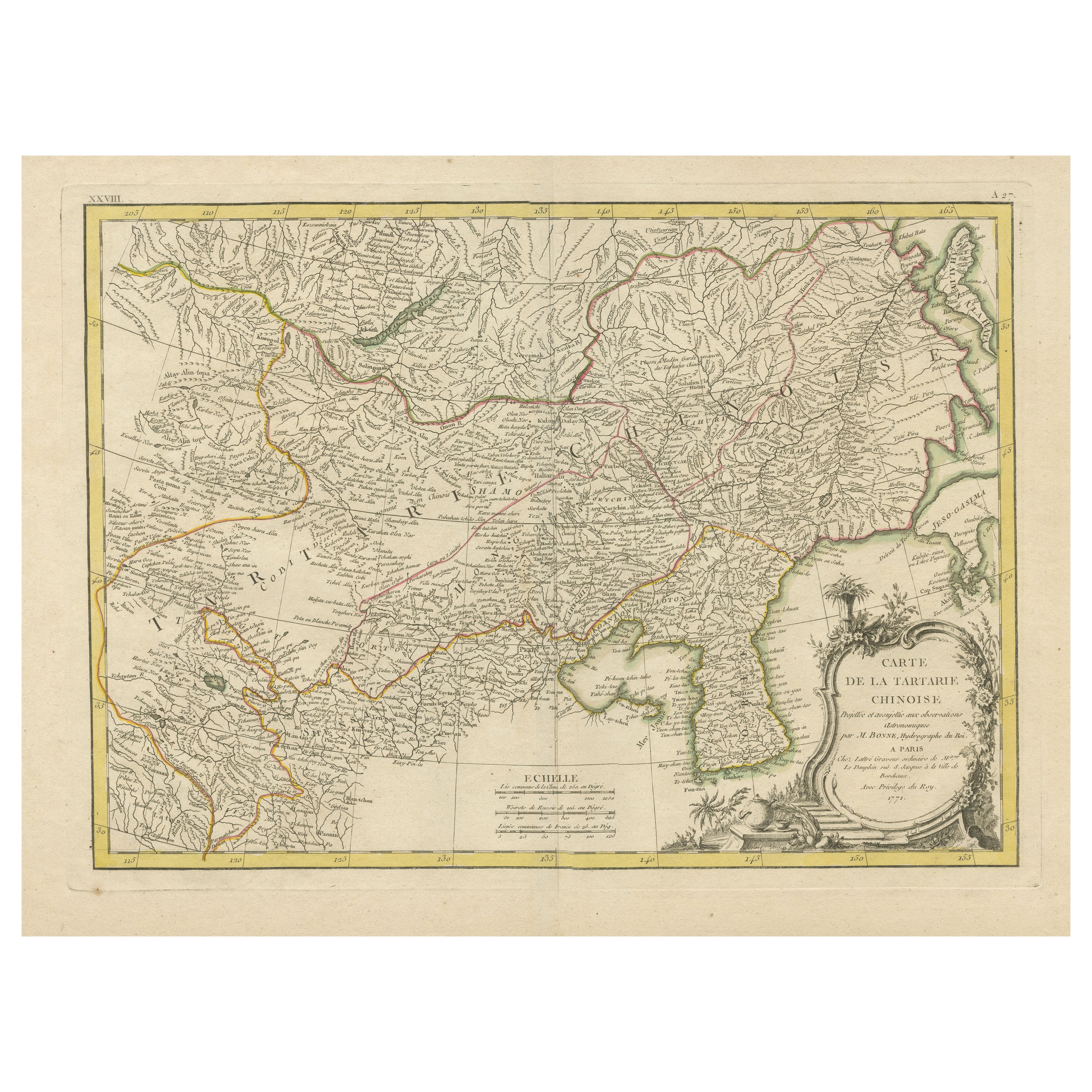
Original Old Map of Present-Day Mongolia, Northeast China and Korea
Located in Langweer, NL
Antique map titled 'Carte de la Tartarie Chinoise. Projettee et assujettie aux observations astronomiques par M. Bonne, Hydrographe du Roi. A Paris, Chez Lattre Graveur, ordinaire de...
Category
Antique Late 18th Century Maps
Materials
Paper
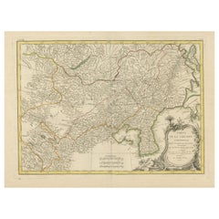
$1,131 Sale Price
20% Off
You May Also Like
Antique 1803 Italian Map of Asia Including China Indoneseia India
Located in Amsterdam, Noord Holland
Antique 1803 Italian Map of Asia Including China Indoneseia India
Very nice map of Asia. 1803.
Additional information:
Type: Map
Country of Manufacturing: Europe
Period: 19th centu...
Category
Antique 19th Century European Maps
Materials
Paper

$584 Sale Price
20% Off
1851 Map of "Independent Tartary", Ric. R018
Located in Norton, MA
1851 Map of
Independent Tartary
"Russia"
Ric.r018
A highly decorative 1851 map of Independent Tartary by John Tallis and John Rapkin. Covers the regions between the Caspian Sea and Lake Bakquash and between Russia and Afghanistan. These include the ancient Silk Route kingdoms of Khiva, Tartaria, Kokand, and Bokhara. Today this region roughly includes Kazakhstan, Uzbekistan, Turkmenistan, Kyrgyzstan, and Tajikistan. This wonderful map offers a wealth of detail for anyone with an interest in the Central Asian portion of the ancient Silk Road. Identifies various caravan routes, deserts, wells, and stopping points, including the cities of Bokhara and Samarkand. Three vignettes by W. Bragg decorate the map, these including an image of Tartars on a Journey, a horseback Bride Chase, and a tartar camp site. Surrounded by a vine motif border. Engraved by J. Rapkin for John Tallis's 1851 Illustrated Atlas .
Tartary Antique Map...
Category
Antique 19th Century Unknown Maps
Materials
Paper

Original Antique Map of China, Arrowsmith, 1820
Located in St Annes, Lancashire
Great map of China
Drawn under the direction of Arrowsmith
Copper-plate engraving
Published by Longman, Hurst, Rees, Orme and Brown, 1820
Unfr...
Category
Antique 1820s English Maps
Materials
Paper

Super Rare Antique French Map of Chine and the Chinese Empire, 1780
Located in Amsterdam, Noord Holland
Super Rare Antique French Map of Chine and the Chinese Empire, 1780
Very nice map of Asia. 1780 Made by Bonne.
Additional information:
Type: Map
...
Category
Antique 18th Century European Maps
Materials
Paper

$584 Sale Price
32% Off
Large Original Antique Map of Afghanistan. Edward Weller, 1861
Located in St Annes, Lancashire
Great map of Afghanistan
Lithograph engraving by Edward Weller
Original colour
Published, 1861
Unframed
Good condition
Category
Antique 1860s English Victorian Maps
Materials
Paper

Original Antique Map of Ancient Greece, Achaia, Corinth, 1786
Located in St Annes, Lancashire
Great map of Ancient Greece. Showing the region of Thessaly, including Mount Olympus
Drawn by J.D. Barbie Du Bocage
Copper plate engraving by P.F Tardieu
Original hand color...
Category
Antique 1780s French Other Maps
Materials
Paper

More Ways To Browse
Iran Map
1681 Moses Pitt
Antique Maps Washington Dc
Ithaca Antique Map
J Thayer
Rust Red Rug
Vintage Studio Chair
1890s French Posters
Casa Finland
Mobelfabrik Danish
Playful Chair
Giacometti Chairs
Antique Rug Wool Navy Blue Red
Bauhaus Flower Stand
French Table With Drawers
North Carolina Furniture
Antique Silver Platter
Boat Blueprint