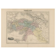
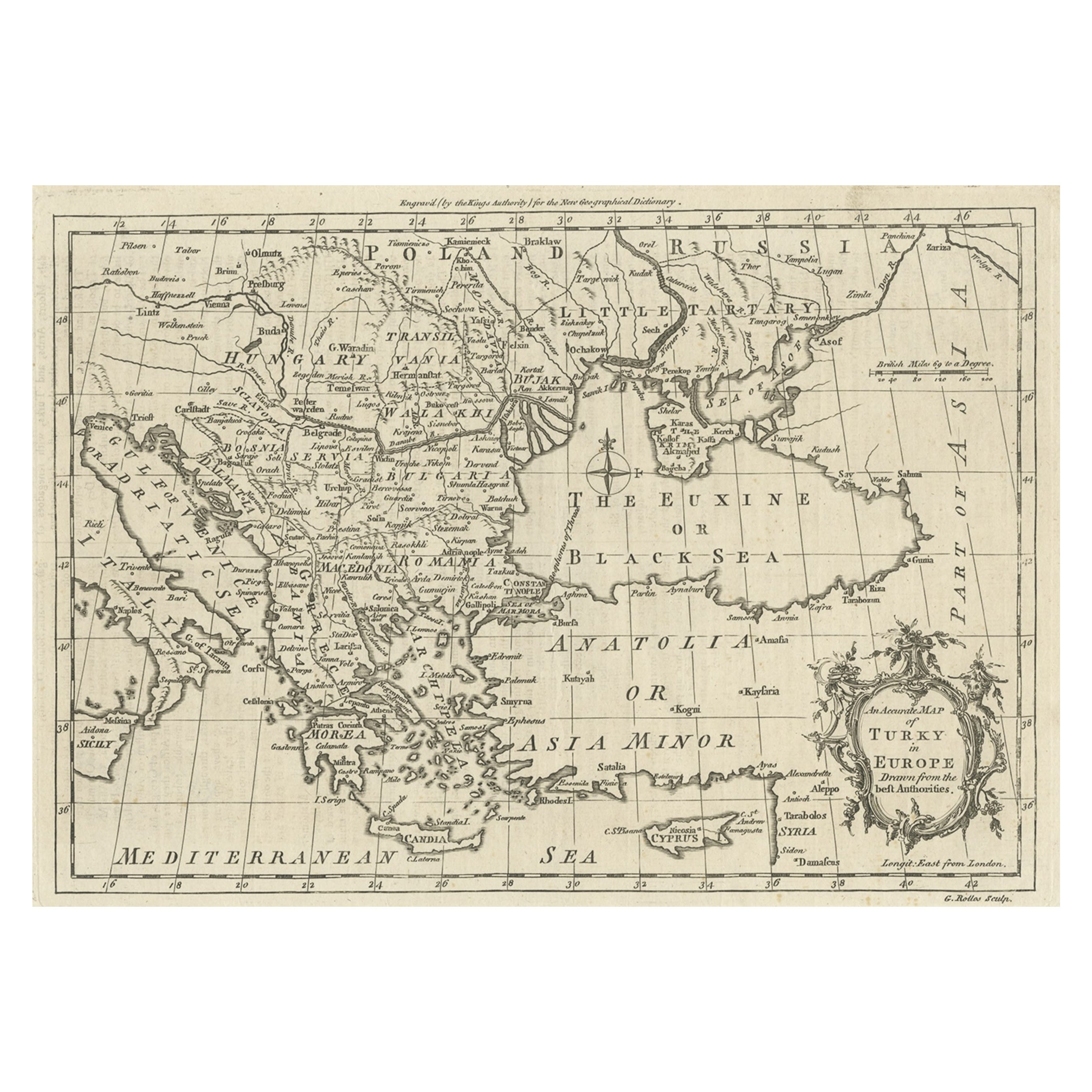
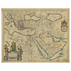
Antique Map Covering the Mid-19th Century Claims of The Ottoman Empire, 1884
View Similar Items


Want more images or videos?
Request additional images or videos from the seller
1 of 6
Auction endedBrowse Current Auctions
Antique Map Covering the Mid-19th Century Claims of The Ottoman Empire, 1884
About the Item
- Dimensions:Height: 13.39 in (34 cm)Width: 18.71 in (47.5 cm)Depth: 0 in (0.02 mm)
- Materials and Techniques:
- Period:
- Date of Manufacture:1884
- Condition:Condition: Good, general age-related toning. Original folding line, blank verso. Please study image carefully.
- Seller Location:Langweer, NL
- Reference Number:Seller: PCT-225 1stDibs: LU3054326527812
About the Seller
5.0
Platinum Seller
These expertly vetted sellers are 1stDibs' most experienced sellers and are rated highest by our customers.
Established in 2009
1stDibs seller since 2017
1,919 sales on 1stDibs
More From This SellerView All
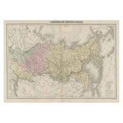
- Original Antique Map Covering the Russian Empire in Asia, 1880Located in Langweer, NLAntique map titled 'Sibérie ou Russie d'Asie'. Migeon's map covers the Russian empire in Asia from european Russia and the Ural Mountains to the Bering Strait and from the Arctic...Category
Antique 1880s Maps
MaterialsPaper
- Mid 19th Century Map of the Black Sea with Decorative Vignettes, 1851Located in Langweer, NLMap of the Black Sea and contingent lands, including Turkey, Russia, Georgia, Azerbaijan, Bulgaria, Crimea and Armenia, with decorative vignettes views of Sebastopol, Varna, Odessa, Sinope, Constantinople and Silistria. Fine antique map...Category
Antique Mid-19th Century Maps
MaterialsPaper
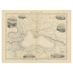 $393 Sale Price20% Off
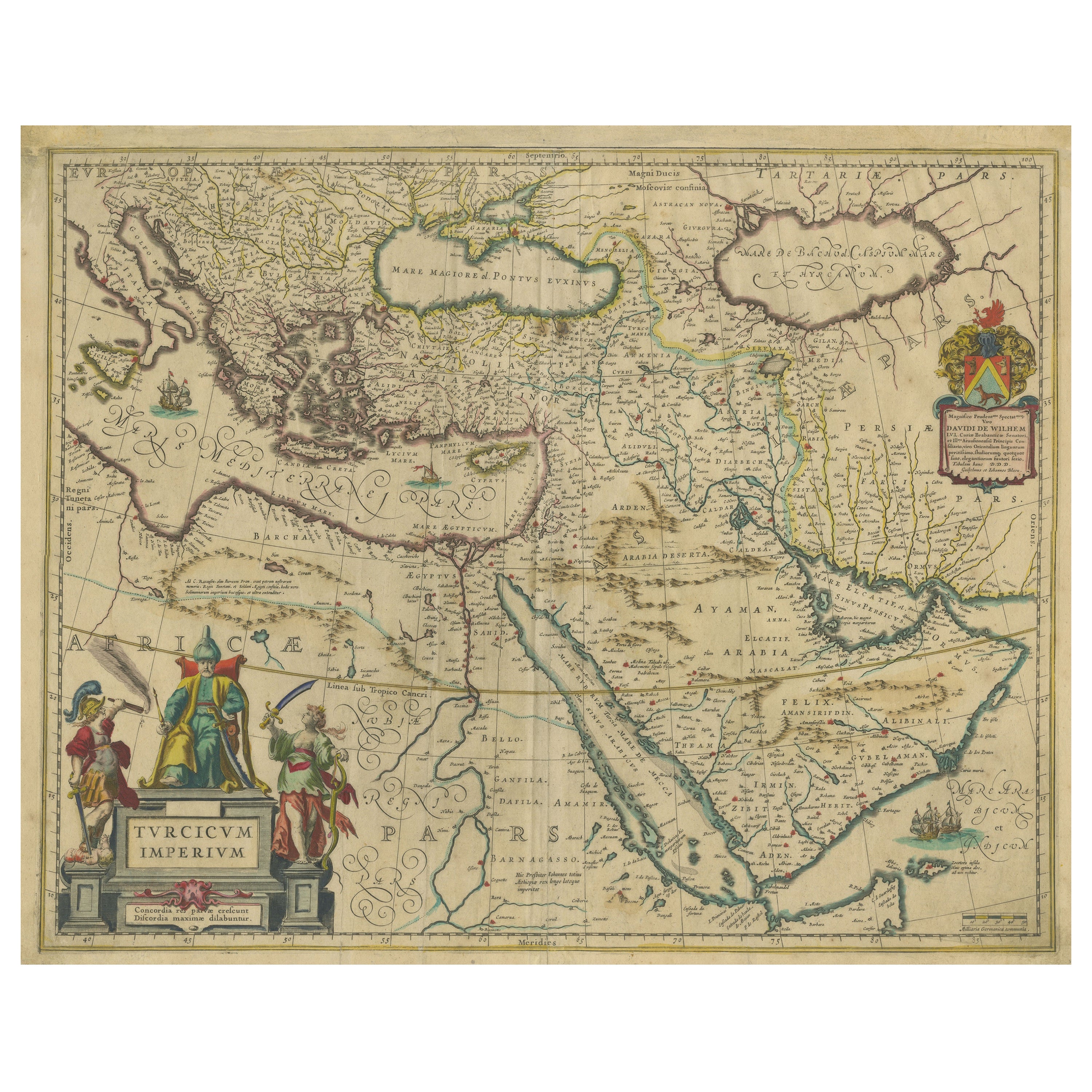
 - Imperial Splendor: Antique Map of the Ottoman Empire by Blaeu, circa 1640Located in Langweer, NLThe antique map titled 'Turcicum Imperium' is an original old map of the Ottoman Empire, historically and colloquially known as the Turkish Empire. Here are the key features and deta...Category
Antique Mid-17th Century Maps
MaterialsPaper
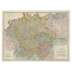
- Large Antique Map of the German EmpireLocated in Langweer, NLAntique map titled 'A Map of Germany (..)'. Large antique map of the German Empire, highly detailed. Engraved by T. Kitchin. Published J. Blair, cir...Category
Antique Late 18th Century Maps
MaterialsPaper
- Antique Map of the Extension of the Russian Empire in the XIXth Century, 1806Located in Langweer, NLAntique map titled 'L'Empire Russe en Europe et en Asie'. Map showing the extension of the Russian Empire at the beginning of the XIXth century. Several letterpress notations are...Category
Antique Early 1800s Maps
MaterialsPaper
 $489 Sale Price20% Off
 - Antique Map of Java in 4 sheets by Dornseiffen, 1884Located in Langweer, NLDetailed map of Java in 4 sheets, with an inset map of Batavia (Jakarta). This map originates from 'Atlas van Nederlandsch Oost- en West-Indie' by Dr. I. Dornseiffen. Published by Se...Category
Antique Late 19th Century Maps
MaterialsPaper

You May Also Like
- Louisiana: A Framed 19th Century Map by O. W. GrayBy Gray and CoLocated in Alamo, CAThis framed 19th century map of the Louisiana territory was published in "Gray's Atlas of the United States with General Maps of the World, accompanied by Descriptions Geographical, Historical, Scientific and Statistica" published in 1873 in Philadelphia by O.W. Gray and Son and Stedman, Brown and Lyon. It is a highly detailed map of Louisiana...Category
Antique Mid-19th Century American Other Maps
MaterialsPaper
- Antique 18th Century Map of the Province of Pensilvania 'Pennsylvania State'Located in Philadelphia, PAA fine antique of the colony of Pennsylvania. Noted at the top of the sheet as a 'Map of the province of Pensilvania'. This undated and anonymous map is thought to be from the Gentleman's Magazine, London, circa 1775, although the general appearance could date it to the 1760's. The southern boundary reflects the Mason-Dixon survey (1768), the western boundary is placed just west of Pittsburgh, and the northern boundary is not marked. The map has a number of reference points that likely refer to companion text and appear to be connected to boundaries. The western and southern boundaries are marked Q, R, S, for example. A diagonal line runs from the Susquehanna R to the Lake Erie P. A broken line marked by many letters A, B, N, O, etc., appears in the east. There are no latitude or longitude markings, blank verso. Framed in a shaped contemporary gilt wooden frame and matted under a cream colored matte. Bearing an old Graham Arader Gallery...Category
Antique 18th Century British American Colonial Maps
MaterialsPaper
- America "Amérique Septentrionale": A 19th Century French Map by DelamarcheBy Maison Delamarche 1Located in Alamo, CAThis framed mid 19th century map of North America entitled "Amérique Septentrionale" by Felix Delamarche was published in Paris in 1854 by Quay de l'Horloge du Palais, avec les Carte...Category
Antique Mid-19th Century American Other Maps
MaterialsPaper
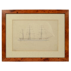
- Print No. 1 of 400 Depicting a Nautical Schooner Made in the Mid-19th CenturyLocated in Milan, ITPrint depicting a schooner, no. 1 of 400 copies signed Z21, made in the mid-19th century. Non-coeval briarwood frame; measures with frame 50 x 40 cm.Category
Antique 1850s British Nautical Objects
MaterialsPaper
- Map of the Republic of GenoaLocated in New York, NYFramed antique hand-coloured map of the Republic of Genoa including the duchies of Mantua, Modena, and Parma. Europe, late 18th century. Dimension: 25...Category
Antique Late 18th Century European Maps
- Antique Map of Principality of MonacoBy Antonio Vallardi EditoreLocated in Alessandria, PiemonteST/619 - "Old Geographical Atlas of Italy - Topographic map of ex-Principality of Monaco" - ediz Vallardi - Milano - A somewhat special edition ---Category
Antique Late 19th Century Italian Other Prints
MaterialsPaper
 $227 Sale Price74% Off


Recently Viewed
View AllMore Ways To Browse
Midcentury Modern Other Antique Furniture
Mid Century Modern Other Antique Furniture
Mid Century Modern Furniture Other Antique Furniture
Antique Ukrainian
Ukraine Antique
Antique French Ottoman
French Mid Century Ottoman
Ancient Egyptian Antiques
Ottoman Empire Antique
Topographical Map
Artist Ottoman
Little Paris Antiques
Map Of South Of France
General Empire
Antique Mid Century Ottoman
Israel Mid Century Modern Furniture
Greek Map
Map Greece