Items Similar to Antique Map of the Maluku Islands 'Ambon' by Stemler, 1874


Want more images or videos?
Request additional images or videos from the seller
1 of 5
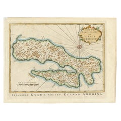
Antique Map of the Maluku Islands 'Ambon' by Stemler, 1874
About the Item
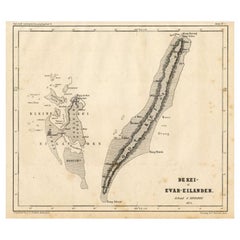
Antique map titled 'Peta deri Poeloe Poeloe Ambon ...' (The Island of Ambon.) This very scarce map shows the Maluku Islands of Ambon, Buru, Banda. South Moluccas. Originates from 'Tijdschrift Aardrijkskundig Genootschap', published by C. F. Stemler in Amsterdam, 1874.
Artists and Engravers: Lithograped by Tresling and Co., Amsterdam.
Condition: Good, general age related toning; some light staining from handling. Please study image carefully.
Date: 1874
Overall size: 46.5 x 32 cm.
Image size: 42 x 28 cm.
We sell original antique maps to collectors, historians, educators and interior decorators all over the world. Our collection includes a wide range of authentic antique maps from the 16th to the 20th centuries. Buying and collecting antique maps is a tradition that goes back hundreds of years. Antique maps have proved a richly rewarding investment over the past decade, thanks to a growing appreciation of their unique historical appeal. Today the decorative qualities of antique maps are widely recognized by interior designers who appreciate their beauty and design flexibility. Depending on the individual map, presentation, and context, a rare or antique map can be modern, traditional, abstract, figurative, serious or whimsical. We offer a wide range of authentic antique maps for any budget
- Dimensions:Height: 12.6 in (32 cm)Width: 18.31 in (46.5 cm)Depth: 0 in (0.01 mm)
- Materials and Techniques:
- Period:
- Date of Manufacture:1874
- Condition:
- Seller Location:Langweer, NL
- Reference Number:
About the Seller
5.0
Platinum Seller
These expertly vetted sellers are 1stDibs' most experienced sellers and are rated highest by our customers.
Established in 2009
1stDibs seller since 2017
1,933 sales on 1stDibs
Typical response time: <1 hour
- ShippingRetrieving quote...Ships From: Langweer, Netherlands
- Return PolicyA return for this item may be initiated within 14 days of delivery.
More From This SellerView All
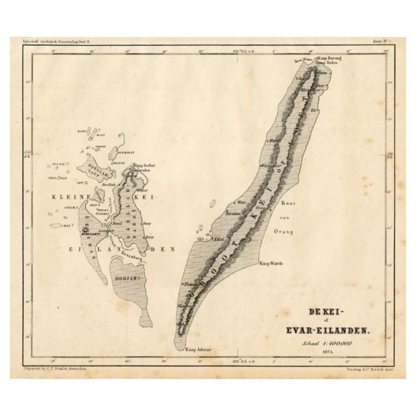
- Antique Map of the Kai Islands by Stemler, c.1875Located in Langweer, NLAntique map titled 'De Kei- of Evar eilanden.' (Kai Islands.) This map shows the Indonesian Kai Islands. Originates from 'Tijdschrift Aardrijkskundig Genootschap', published by C. F....Category
Antique 19th Century Maps
MaterialsPaper
- Antique Map of the Maluku Islands by Blaeu, c.1640Located in Langweer, NLAntique map titled 'Moluccae Insulae Celeberrimae'. Decorative map of the Maluku Islands, also known as the Moluccas or the Spice Islands. Inset of the island of Bachian (Batjan) in ...Category
Antique 17th Century Maps
MaterialsPaper
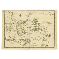
- Antique Map of the Maluku Islands by Bellin, c.1750By Jacques-Nicolas BellinLocated in Langweer, NLAntique map titled 'Carte Particuliere des Isles Moluques'. This map depicts the islands of Herij, Ternate, Tidor, Pottebackers, Timor, Machian and Bachian. The Moluccan islands were...Category
Antique 18th Century Maps
MaterialsPaper
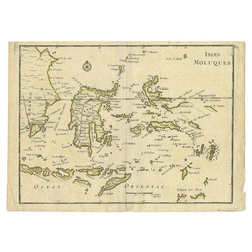
- Antique Map of the Maluku Islands by Le Rouge, c.1750By George Louis Le RougeLocated in Langweer, NLAntique map Moluccas/Spice Islands titled 'Isles Moluques'. Detailed map of the famous Spice Islands (Maluku Islands or the Moluccas). Includes also Sulawesi, Bali, Timor, part of Bo...Category
Antique 18th Century Maps
MaterialsPaper
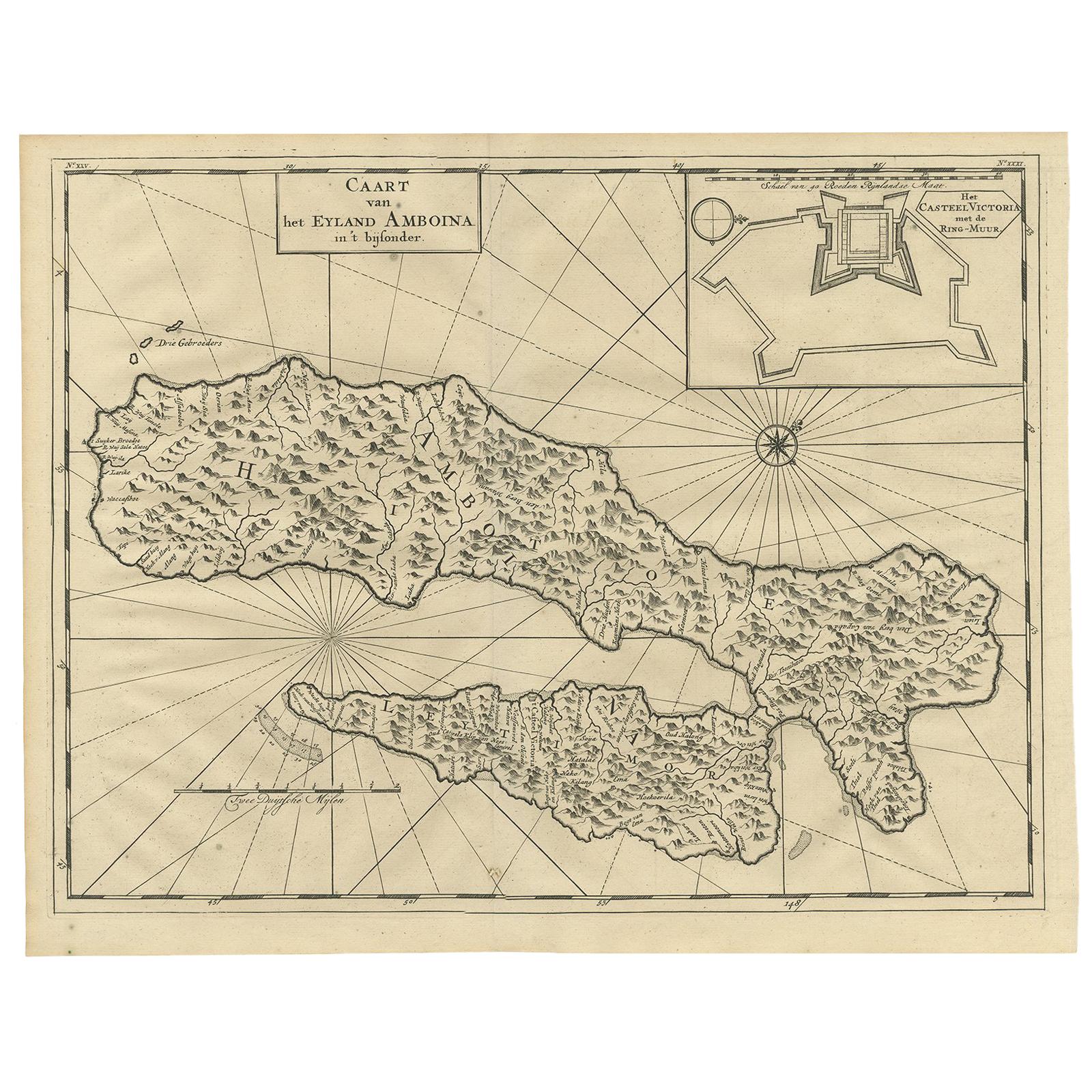
- Antique Map of Ambon Island by Valentijn, 1726By F. ValentijnLocated in Langweer, NLAntique map titled 'Caart van het Eyland Amboina in 't bijsonder'. Map of the Islands Ambon and Timor, one of the Moluccan Islands, Indonesia, with an inset of castle Victoria with t...Category
Antique Early 18th Century Dutch Maps
MaterialsPaper
- Antique Map of Ambon Island, Indonesia, 1756Located in Langweer, NLAntique map titled ‘Carte particuliere de l'Isle d'Amboine - Byzondere kaart van het eyland Amboina’. Antique map of the island of Ambon, Indonesia. This map originates from 'Histori...Category
Antique 18th Century Maps
MaterialsPaper


You May Also Like
- 1854 Map of Massachusetts, Connecticut and Rhode Island, Antique Wall MapLocated in Colorado Springs, COThis striking wall map was published in 1854 by Ensign, Bridgman & Fanning and has both full original hand-coloring and original hardware. This impression is both informative and highly decorative. The states are divided into counties, outlined in red, green, and black, and subdivided into towns. Roads, canals, and railroad lines are prominently depicted, although they are not all labeled. The mapmakers also marked lighthouses, banks, churches, and prominent buildings, with a key at right. The map is an informative and comprehensive overview of the infrastructural development of New England prior to the Civil War. Physical geographies depicted include elevation, conveyed with hachure marks, rivers and lakes. The impression features an inset map of Boston...Category
Antique 19th Century American Maps
MaterialsPaper
- 1861 Topographical Map of the District of Columbia, by Boschke, Antique MapLocated in Colorado Springs, COPresented is an original map of Albert Boschke's extremely sought-after "Topographical Map of the District of Columbia Surveyed in the Years 1856 ...Category
Antique 1860s American Historical Memorabilia
MaterialsPaper
- Large Original Antique Map of Rhode Island, USA, C.1900Located in St Annes, LancashireFabulous map of Rhode Island Original color Engraved and printed by the George F. Cram Company, Indianapolis. Published, C.1900 Unframed Free ...Category
Antique 1890s American Maps
MaterialsPaper
- Large Original Vintage Map of The Pacific Islands Including HawaiiLocated in St Annes, LancashireGreat map of The Pacific Islands Unframed Original color By John Bartholomew and Co. Edinburgh Geographical Institute Published, circa 1...Category
Vintage 1920s British Maps
MaterialsPaper
- 1868 Map of the Upper Part of the Island of Manhattan Above 86th StreetBy Wm. Rogers Mfg. Co.Located in San Francisco, CAThis wonderful piece of New York City history is over 150 years old. It depicts 86th street and above. It was lithographed by WC Rogers and company. It was made to show what was the Battle of Harlem during the Revolutionary war...Category
Antique 1860s American American Colonial Maps
MaterialsPaper
- Framed Mid-19th Century Wall Map of Long Island, the HamptonsLocated in Sag Harbor, NYA Framed museum quality find. This large wall map dates to the mid-1800s. Detailed inset maps of, Sag Harbor, East Hampton, Amagansett, Shelter Island and most villages in Long Islan...Category
Antique Mid-19th Century American Maps
MaterialsLinen, Paper


Recently Viewed
View AllMore Ways To Browse
Antique Architecture Plan
Seven Fold
Antique Map Series
Antique Street Maps
Scottish Fold
Antique Doctors Office Furniture
Antique Prints Of A Cross
Atlas Furniture Company
Antique Map Set
Balinese Wood
Portuguese 16th
Atlas Book
Set Of Antique Maps
Pirate Furniture
Antique In Philippines
Victorian Book Ends
Railroad Collectibles
Denmark Maps