Items Similar to Antique Map of the Netherlands by Zannoni, 1765
Want more images or videos?
Request additional images or videos from the seller
1 of 5
Antique Map of the Netherlands by Zannoni, 1765
About the Item
Antique map titled 'Carte Historique, Geographique et Militaire des Campagnes de Louis XIV dans les Pays Bas (..)'. Beautiful old map of the Netherlands. This map originates from 'Atlas Historique de la France Ancienne et Moderne' by M. Rizzi Zannoni.
Artists and Engravers: Published by S. Desons, Paris. Giovanni Rizzi Zannoni (1736-1814 ) was an Italian cartographer and geographer.
Condition: Very good, please study image carefully.
Date: 1765
Overall size: 40 x 28 cm.
Image size: 30 x 24 cm.
We sell original antique maps to collectors, historians, educators and interior decorators all over the world. Our collection includes a wide range of authentic antique maps from the 16th to the 20th centuries. Buying and collecting antique maps is a tradition that goes back hundreds of years. Antique maps have proved a richly rewarding investment over the past decade, thanks to a growing appreciation of their unique historical appeal. Today the decorative qualities of antique maps are widely recognized by interior designers who appreciate their beauty and design flexibility. Depending on the individual map, presentation, and context, a rare or antique map can be modern, traditional, abstract, figurative, serious or whimsical. We offer a wide range of authentic antique maps for any budget.
- Dimensions:Height: 11.03 in (28 cm)Width: 15.75 in (40 cm)Depth: 0 in (0.01 mm)
- Materials and Techniques:
- Period:
- Date of Manufacture:1765
- Condition:
- Seller Location:Langweer, NL
- Reference Number:
About the Seller
5.0
Platinum Seller
These expertly vetted sellers are 1stDibs' most experienced sellers and are rated highest by our customers.
Established in 2009
1stDibs seller since 2017
1,932 sales on 1stDibs
Typical response time: <1 hour
- ShippingRetrieving quote...Ships From: Langweer, Netherlands
- Return PolicyA return for this item may be initiated within 14 days of delivery.
More From This SellerView All
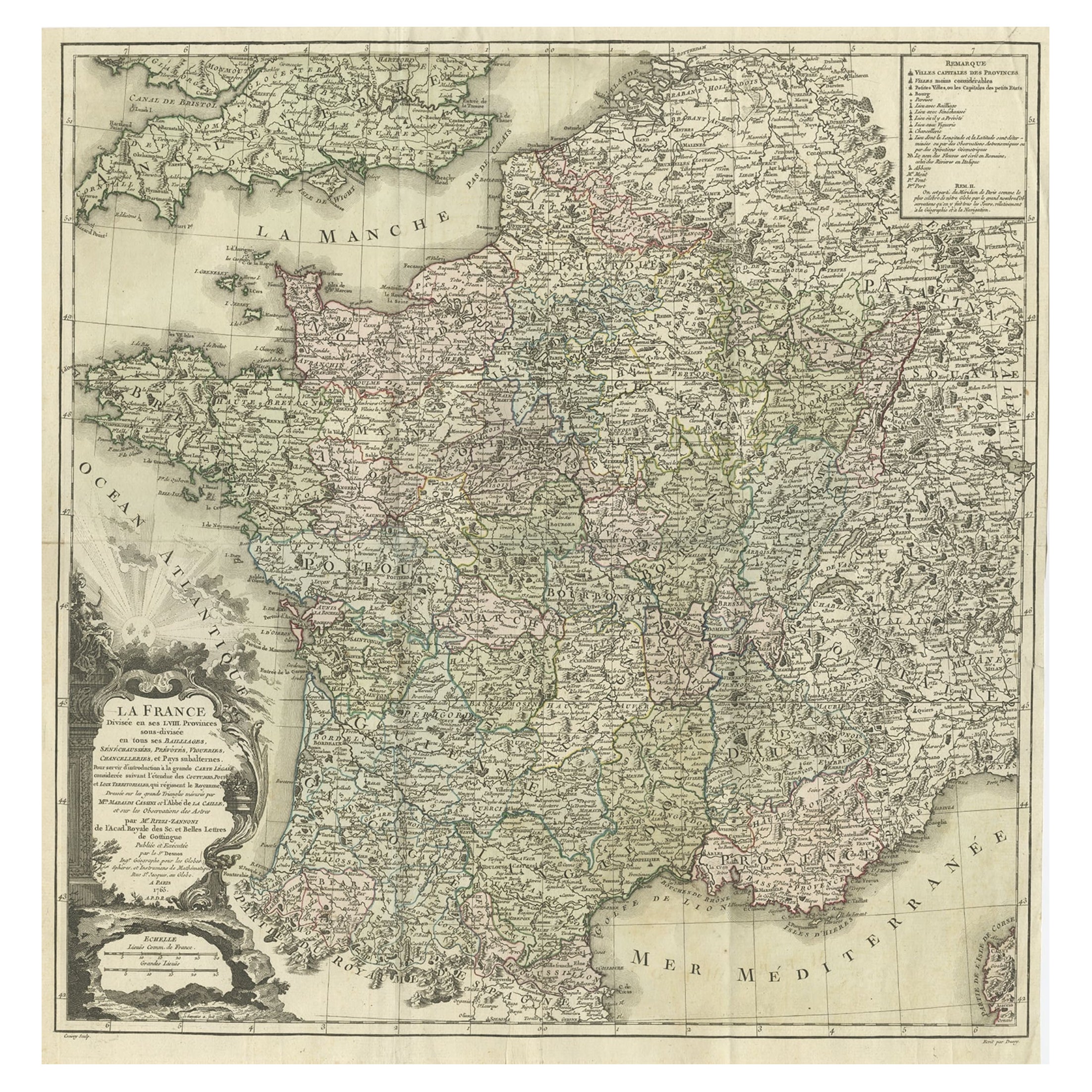
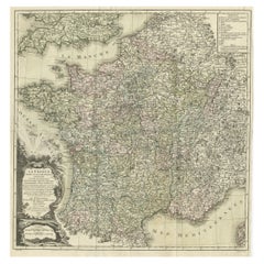
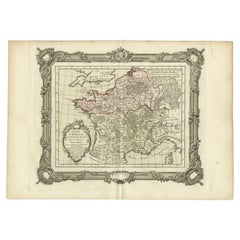
- Antique Map of France by Zannoni, 1765Located in Langweer, NLAntique map titled 'La France divisée en ses LVIII Provinces (..)'. Beautiful old map of France. This map originates from 'Atlas Historique de la France Ancienne et Moderne' by M. Ri...Category
Antique 18th Century Maps
MaterialsPaper
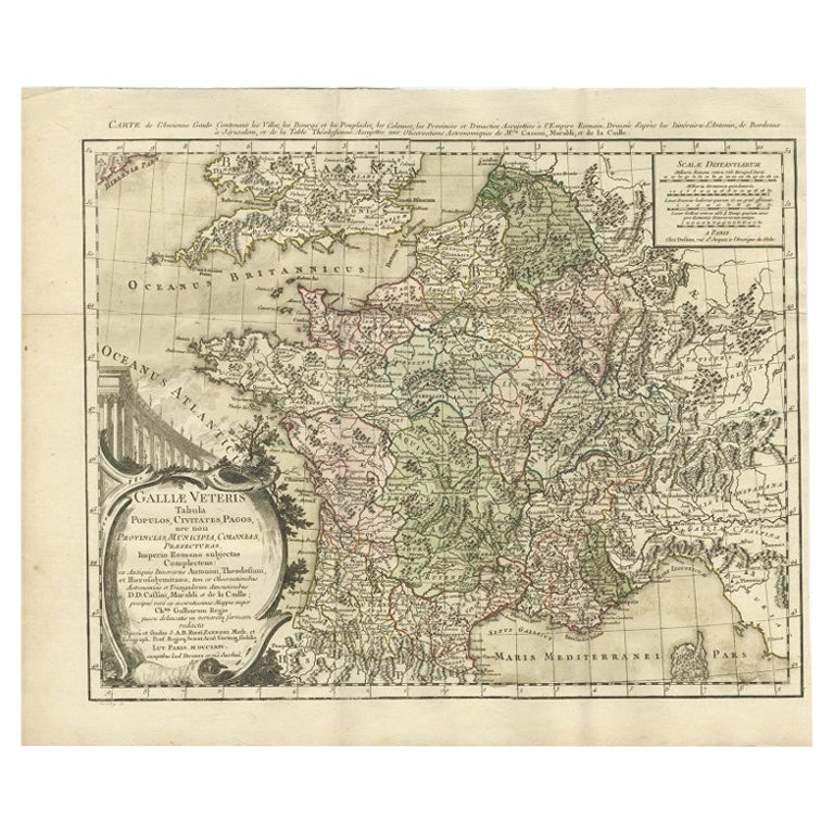
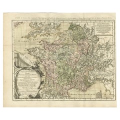
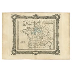
- Antique Map of ancient France by Zannoni, 1765Located in Langweer, NLAntique map France titled 'Galliae Veteris (..)'. Beautiful old map of France. This map originates from 'Atlas Historique de la France Ancienne et Moderne' ...Category
Antique 18th Century Maps
MaterialsPaper
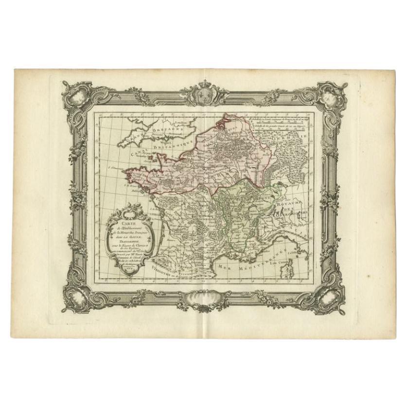
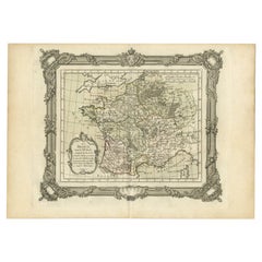
- Antique Map of the Establishment of the French Monarchy by Zannoni, 1765Located in Langweer, NLAntique map France titled 'Carte de l'Etablissement de la Monarchie Francoise (..)'. Beautiful old map of France. This map originates from 'Atlas Historique de la France Ancienne et ...Category
Antique 18th Century Maps
MaterialsPaper
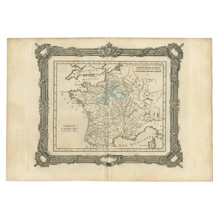
- Antique Map of France under the Second Race by Zannoni, 1765Located in Langweer, NLAntique map France titled 'Tableau du Domaine Royal (..)'. Beautiful old map of France. This map originates from 'Atlas Historique de la France Ancienne et Moderne' by M. Rizzi Zanno...Category
Antique 18th Century Maps
MaterialsPaper
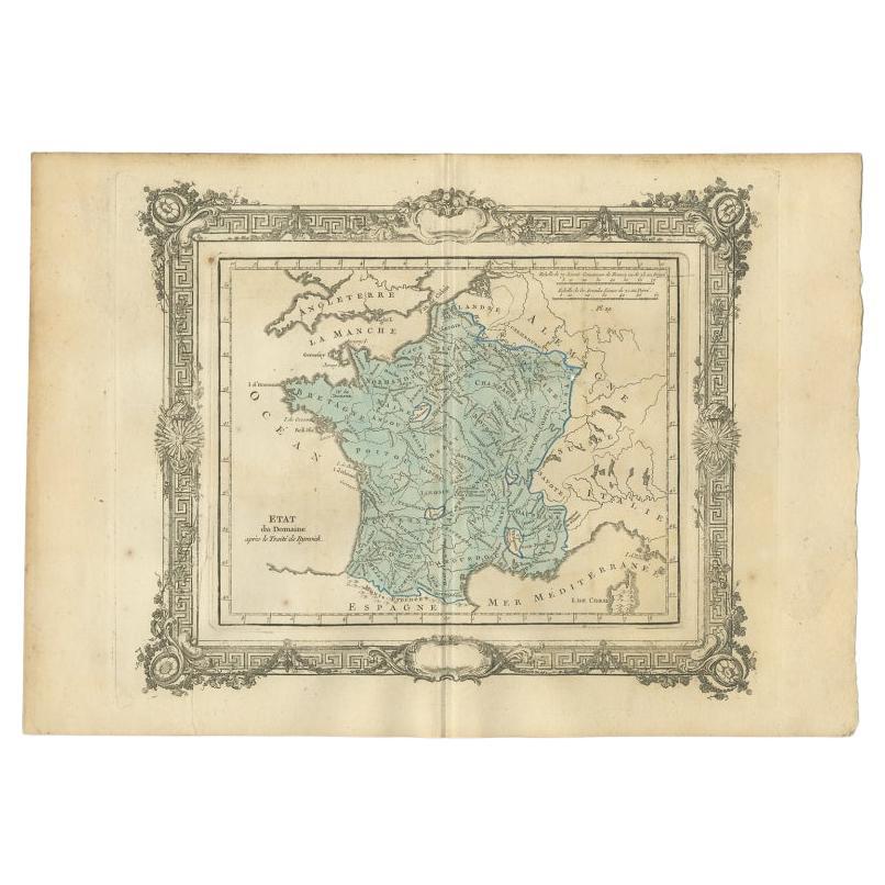
- Antique Map of France After the Peace of Ryswick by Zannoni, 1765By G. A. Rizzi-zannoniLocated in Langweer, NLAntique map France titled 'Etat du Domaine apès le Traité de Ryswick (..)'. Beautiful old map of France. This map originates from 'Atlas Historique de la France Ancienne et Moderne' ...Category
Antique 18th Century Maps
MaterialsPaper
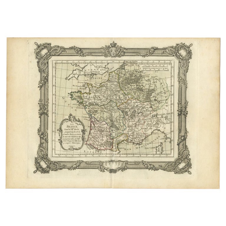
- Antique Map of France in the 7th Century by Zannoni, 1765Located in Langweer, NLAntique map France titled 'La France sous le VIIe Siècle (..)'. Beautiful old map of France. This map originates from 'Atlas Historique de la France Ancienne et Moderne' by M. Rizzi ...Category
Antique 18th Century Maps
MaterialsPaper

You May Also Like
- Original Antique Map of The Netherlands, Engraved by Barlow, Dated 1807Located in St Annes, LancashireGreat map of Netherlands Copper-plate engraving by Barlow Published by Brightly & Kinnersly, Bungay, Suffolk. Dated 1807 Unframed.Category
Antique Early 1800s English Maps
MaterialsPaper
- Original Antique Map of The Netherlands, Sherwood, Neely & Jones, Dated 1809Located in St Annes, LancashireGreat map of The Netherlands Copper-plate engraving by Cooper Published by Sherwood, Neely & Jones. Dated 1809 Unframed.Category
Antique Early 1800s English Maps
MaterialsPaper
- 1861 Topographical Map of the District of Columbia, by Boschke, Antique MapLocated in Colorado Springs, COPresented is an original map of Albert Boschke's extremely sought-after "Topographical Map of the District of Columbia Surveyed in the Years 1856 ...Category
Antique 1860s American Historical Memorabilia
MaterialsPaper
- School Chart or Pull Down Map of Geography of the Netherlands, 1950sLocated in Hemiksem, VANA beautiful old school map of the Netherlands, painted on linen. The map shows the 3 different reliefs (low, middle, high) of the Netherlands. The beau...Category
Vintage 1950s Belgian Mid-Century Modern Maps
MaterialsLinen, Paint
- 1752 Vaugoundy Map of Flanders : Belgium, France, and the Netherlands, Ric.a002Located in Norton, MALarge Vaugoundy Map of Flanders: Belgium, France, and the Netherlands Colored -1752 Ric.a002 Description: This is a 1752 Didier Robert de Vaugondy map of Flanders. The map de...Category
Antique 17th Century Unknown Maps
MaterialsPaper
- Original Antique Map of The World by Thomas Clerk, 1817Located in St Annes, LancashireGreat map of The Eastern and Western Hemispheres On 2 sheets Copper-plate engraving Drawn and engraved by Thomas Clerk, Edinburgh. Published by Mackenzie And Dent, 1817 ...Category
Antique 1810s English Maps
MaterialsPaper


Recently Viewed
View AllMore Ways To Browse
Antique Netherlands
Antique Furniture Netherlands
Antique The Netherlands
Furniture From The 40s
Louis The 16th Furniture
Louis The 16th
30s And 40s French Furniture
Carte Paris
Louis Atlas
Campagne Furniture
Carte Ancienne
Maps By Zannoni
Dan Rizzi
Antique Architecture Plan
Seven Fold
Antique Map Series
Antique Street Maps
Scottish Fold