Items Similar to Antique Map of New Ireland Island in the Bismarck Archipelago, New Guinea, 1772


Want more images or videos?
Request additional images or videos from the seller
1 of 5
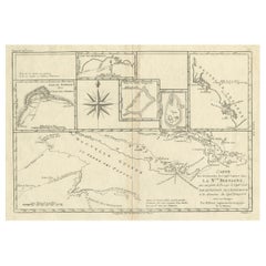
Antique Map of New Ireland Island in the Bismarck Archipelago, New Guinea, 1772
$209.52
$261.9120% Off
£155.73
£194.6720% Off
€176
€22020% Off
CA$289.30
CA$361.6220% Off
A$320.81
A$401.0120% Off
CHF 168.56
CHF 210.7020% Off
MX$3,919.73
MX$4,899.6620% Off
NOK 2,108.93
NOK 2,636.1620% Off
SEK 1,979.59
SEK 2,474.4820% Off
DKK 1,340.15
DKK 1,675.1920% Off
About the Item
Antique map titled 'Nova Hibernia'. Antique map of New Ireland, an island in the Bismarck Archipelago, New Guinea. Lying just north of New Britain, from which it is separated by St. George's Channel, it was once believed to be part of one landmass combining New Britain and New Guinea. This theory was disproved in 1767 when Philip Carteret found St. George's Channel and named the island, Nova Hibernia. The other prints depict islands also part of the Bismarck Archipelago. Artists and Engravers: Philip Carteret: British naval officer and explorer who participated in two of the Royal Navy's circumnavigation expeditions in 1764-66 and 1766-69.
Artist: Philip Carteret: British naval officer and explorer who participated in two of the Royal Navy's circumnavigation expeditions in 1764-66 and 1766-69.
Condition: Good, some discoloration. Please study image carefully.
Date: 1772
Overall size: 44.5 x 28 cm.
Image size: 32.5 x 21 cm.
- Dimensions:Height: 17.52 in (44.5 cm)Width: 11.03 in (28 cm)Depth: 0 in (0.01 mm)
- Materials and Techniques:
- Period:
- Date of Manufacture:1772
- Condition:
- Seller Location:Langweer, NL
- Reference Number:Seller: BG-008241stDibs: LU3054326373802
About the Seller
5.0
Recognized Seller
These prestigious sellers are industry leaders and represent the highest echelon for item quality and design.
Platinum Seller
Premium sellers with a 4.7+ rating and 24-hour response times
Established in 2009
1stDibs seller since 2017
2,609 sales on 1stDibs
Typical response time: <1 hour
- ShippingRetrieving quote...Shipping from: Langweer, Netherlands
- Return Policy
Authenticity Guarantee
In the unlikely event there’s an issue with an item’s authenticity, contact us within 1 year for a full refund. DetailsMoney-Back Guarantee
If your item is not as described, is damaged in transit, or does not arrive, contact us within 7 days for a full refund. Details24-Hour Cancellation
You have a 24-hour grace period in which to reconsider your purchase, with no questions asked.Vetted Professional Sellers
Our world-class sellers must adhere to strict standards for service and quality, maintaining the integrity of our listings.Price-Match Guarantee
If you find that a seller listed the same item for a lower price elsewhere, we’ll match it.Trusted Global Delivery
Our best-in-class carrier network provides specialized shipping options worldwide, including custom delivery.More From This Seller
View AllAntique Map of New Ireland, 1774
Located in Langweer, NL
Antique print titled 'Neu Irrland (..)'. Antique map of New Ireland with 7 coastal profiles, Papua New Guinea. Originates from 'Geschichte der See-Reisen u...
Category
Antique 18th Century Maps
Materials
Paper

$276 Sale Price
20% Off
Antique Map of New Guinea and New Britain by P. Carteret, circa 1773
Located in Langweer, NL
Antique Map: A Chart of Captain Carteret's Discoveries at New Britain (1769)
This rare and historically significant 18th-century map, titled *A Chart of Captn Carteret's Discoveries at New Britain,* offers a fascinating glimpse into early European explorations of the Pacific. Published in 1769, the map meticulously charts Captain Philip Carteret's 1767 voyage through New Guinea and the islands of New Britain and New Ireland, showcasing his contributions to the understanding of the Bismarck Archipelago. Adding to its significance, the map traces the paths of earlier explorer William Dampier...
Category
Antique Late 18th Century Maps
Materials
Paper

$523 Sale Price
20% Off
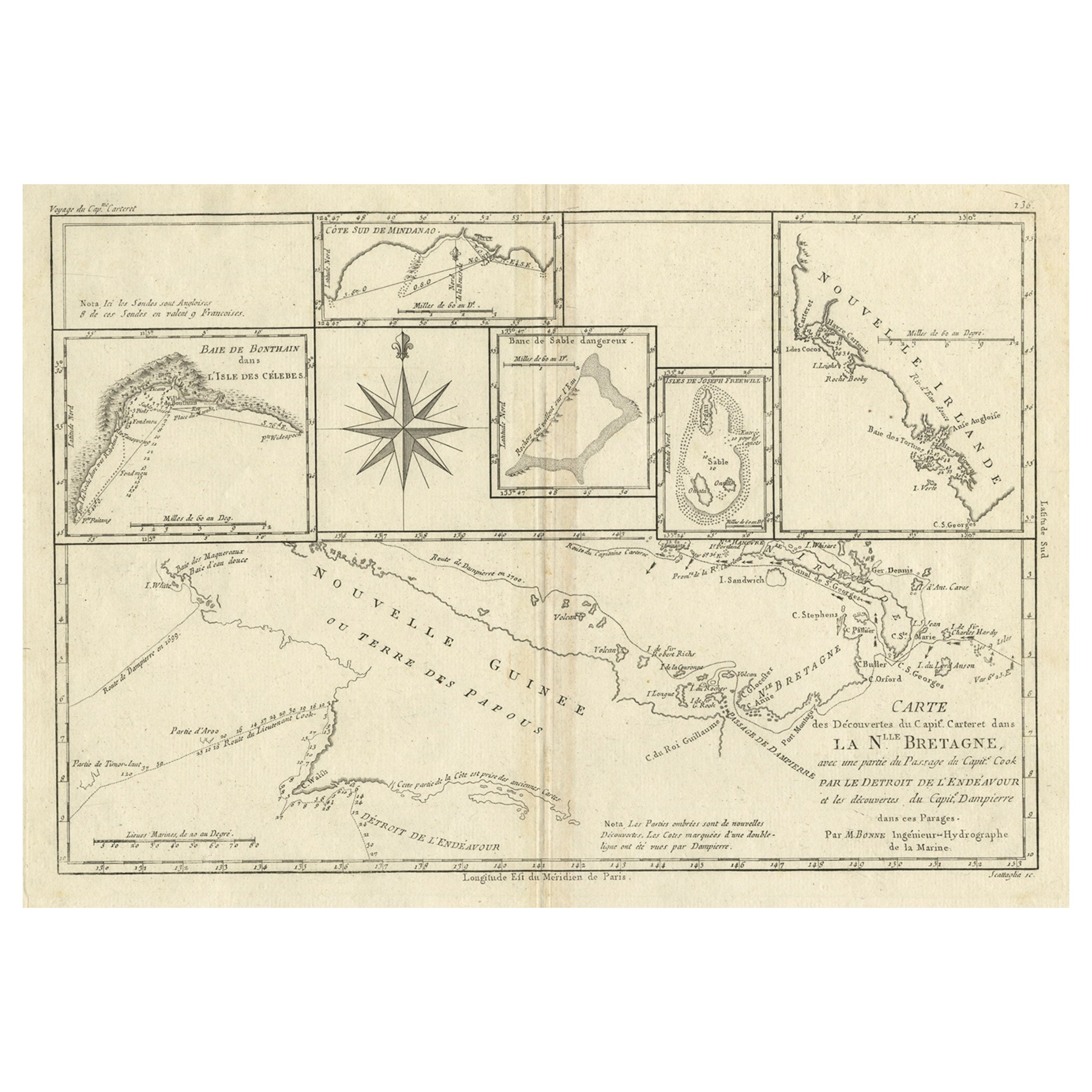
Antique Detailed Map of Papua New Guinea and the Regions to the West, ca.1780
Located in Langweer, NL
Antique map titled 'Carte des Decouvertes du Capite. Carteret dans La Nlle. Bretagne avec une parte du passage du Capite. Cook Par Le Detroit De L'Endeavor ...
Category
Antique 1780s Maps
Materials
Paper
$314 Sale Price
20% Off
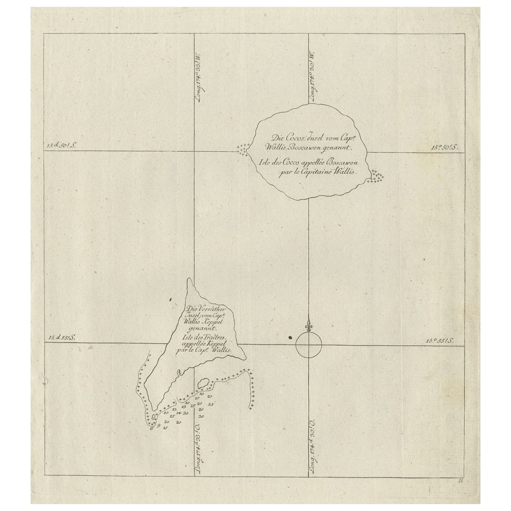
Antique Map of the Cocos or Keeling Islands, 1778
Located in Langweer, NL
Antique map titled 'Die Cocos Insel vom Capt. Wallis Bosawren. Die Verrather Islel von Capt. Wallis Keppel Genannt'. Also with French subtitles. Old map of the Cocos or Keeling Islan...
Category
Antique 18th Century Maps
Materials
Paper
$276 Sale Price
20% Off
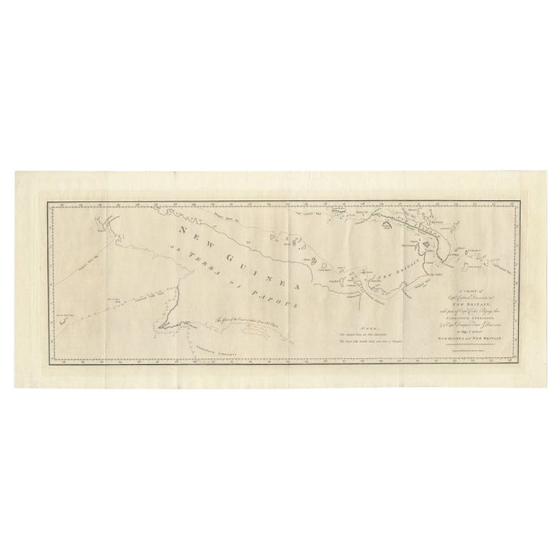
Large Antique Map of New Guinea and New Britain Showing Capt. Cooks Tract, 1773
Located in Langweer, NL
Antique map titled 'A Chart of Captain Carteret's Discoveries at New Britain, with part of Captain Cooke's Passage thro Endeavour Streights, & of Captain Dampier's tract & discoverie...
Category
Antique 18th Century Maps
Materials
Paper
$523 Sale Price
20% Off
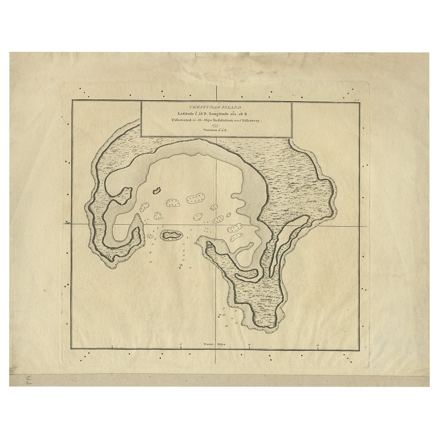
Antique Map of Christmas Island by Cook, 1784
Located in Langweer, NL
Antique map Kiribati titled 'Christmas Island (..)'. Antique map of Christmas Island, also known as Kiritimati. Originates from an edition of Cook's Voyages.
Artists and Engravers...
Category
Antique 18th Century Maps
Materials
Paper
$104 Sale Price
20% Off
You May Also Like
Antique French Map of Asia Including China Indoneseia India, 1783
Located in Amsterdam, Noord Holland
Very nice map of Asia. 1783 Dedie au Roy.
Additional information:
Country of Manufacturing: Europe
Period: 18th century Qing (1661 - 1912)
Condition: Overall Condition B (Good Used)...
Category
Antique 18th Century European Maps
Materials
Paper

$648 Sale Price
20% Off
1814 Map of "Russian Empire" Ric.r032
Located in Norton, MA
1814 Map of
"Russian Empire"
Ric.r032
Russian Empire. Description: This is an 1814 John Thomson map of the Russian Empire. The map depicts the region from the Baltic Sea, Prussia, and Sweden to the Aleutian Islands and from the Arctic Ocean to the Yellow River. Highly detailed, myriad cities, towns, and villages are labeled throughout, including St. Petersburg, Moscow, Minsk, Kiev, and Kharkov. Rivers and mountain ranges are also identified, as are islands and numerous locations along the coastlines. It is important to note that the long-disputed sea between Korea and Japan is identified as the 'Sea of Japan.
Historical Context:
In 1815, Tsarist Russia emerged from the Napoleonic Wars economically insolvent and politically fearful of the Revolutionary fervor that had just swept through Europe. In order to shore up Russia's economic position, the Tsars began an aggressive series of expansions into the Caucuses and Central Asia that would vastly increase the landmass of the Russian Empire.
Publication History
Thomson maps are known for their stunning color, awe inspiring size, and magnificent detail. Thomson's work, including this map, represents some of the finest cartographic art...
Category
Antique 19th Century Unknown Maps
Materials
Paper

Extremely Large Hand-Drawn Manuscript Map of Surinam, 1830, History of Slavery
Located in Amsterdam, NL
A unique large hand-drawn map of Surinam by Albrecht Helmut Hiemcke (German, 1760-1839)
?
'Colonie Surinaame', 1830
A large hand-drawn and coloured map of the colony of Suri...
Category
Antique Mid-19th Century Surinamer Maps
Materials
Paper

1654 Joan Blaeu Map the Sutherland, Scotland, Entitled "Southerlandia, "Ric0007
Located in Norton, MA
1654 Joan Blaeu map of the
Sutherland, Scotland, entitled
"Southerlandia,"
Hand Colored
Ric0007
Description:
Lovely map centered on Sedan and D...
Category
Antique 17th Century Dutch Maps
Materials
Paper

Original Antique Map of South America. C.1780
Located in St Annes, Lancashire
Great map of South America
Copper-plate engraving
Published C.1780
Two small worm holes to left side of map
Unframed.
Category
Antique Early 1800s English Georgian Maps
Materials
Paper

1812 United States Map, by Pierre Tardieu, Antique French Map Depicting the U.S.
By Pierre François Tardieu
Located in Colorado Springs, CO
1812 "United States of Nth America -- Carte des Etats-Unis De L'Amerique Septentrionale" Two-Sheet Map by Tardieu
This attractive map, published in Paris in 1812, is one of the most rare large format maps from the period. It features a view of the East Coast of the U.S. from Maryland to just below South Carolina. Additionally, Ellicott’s plan for the City of Washington D.C. is included at the top right and an illustration of Niagara Falls is shown at the bottom right with a description in both French and English. This extremely detailed map not only depicts the mountainous regions of the southeastern U.S., but also includes names of regions, rivers, and towns.
Based on the first state of Arrowsmith’s 4-sheet map of the United States, this map is completely engraved by Tardieu in Paris and showcases high quality engravings. This detailed map of the recently independent United States includes one of the largest and earliest examples of the Ellicott plan of Washington DC.
The artist, Pierre François Tardieu (PF Tardieu) was a very well-known map engraver, geographer, and illustrator. Awarded a bronze medal by King Louis-Phillipe for the accuracy and beauty of his map-making, Tardieu produced many fine works including maps of Louisiana...
Category
Antique 1810s French Maps
Materials
Paper

More Ways To Browse
Royal Navy Antique
British Royal Navy
18th Century Naval
Philip North
Caribbean Colonial Furniture
Antique Maps West Indies
California Island Map
Pirate Antique
Map Of Holy Land
Antique Blackwood Furniture
Antique Macedonia
Antique Maps Of New York City
Victorian Compass
Antique Maps Caribbean Islands
Hungary Map
Cartographer Tool
Goa Furniture
George Fleet