Items Similar to Antique Map of North America by Laarman, c.1860


Want more images or videos?
Request additional images or videos from the seller
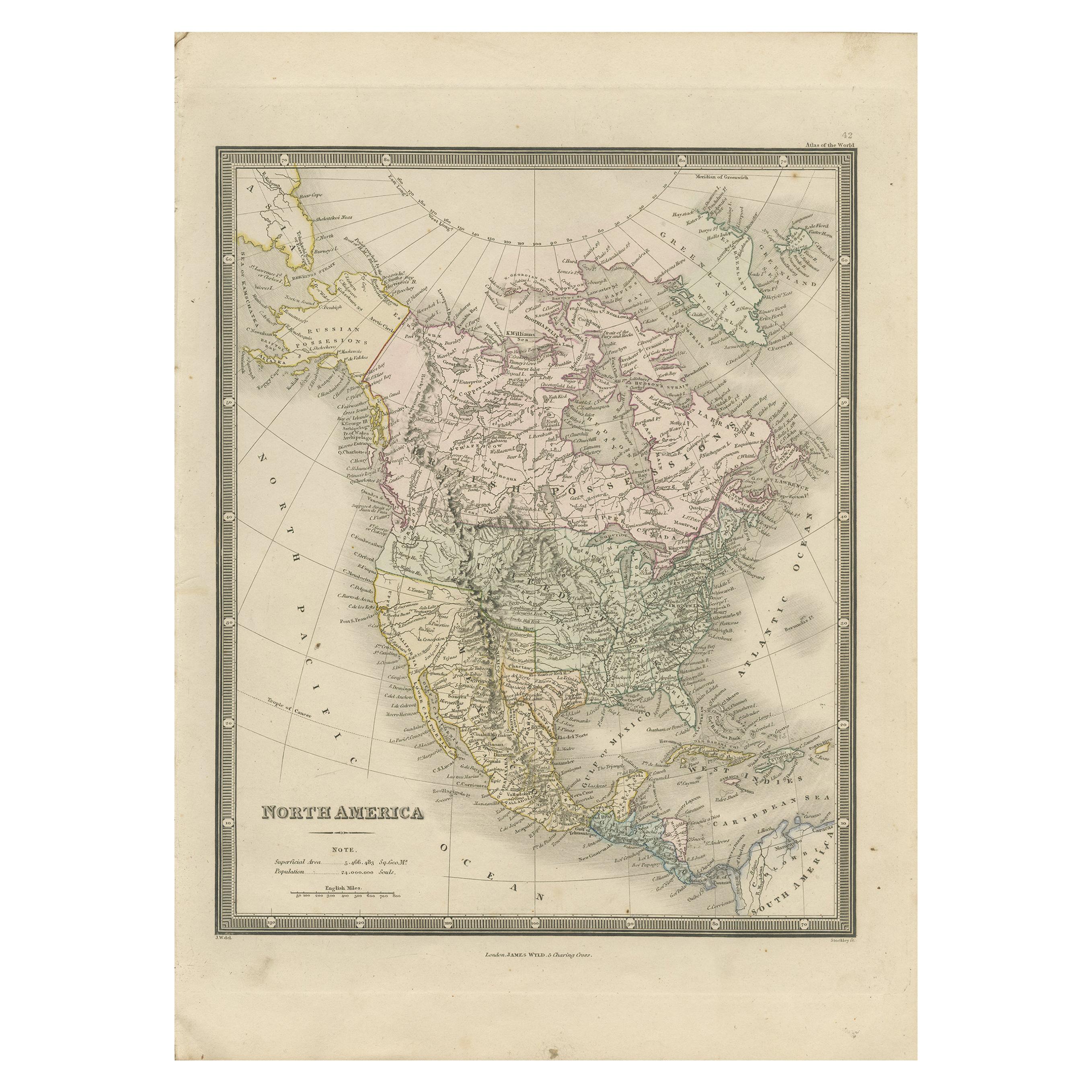
Antique Map of North America by Laarman, c.1860
About the Item
Antique map titled 'Noord Amerika'. Original antique map of North America. Published circa 1860. Artists and Engravers: Published by J.H. Laarman.
Artist: Published by J.H. Laarman.
Condition: Fair, strong toning. Original folding line, with repaired split. Shows some wear and soiling, blank verso. Please study image carefully.
- Dimensions:Height: 12.8 in (32.5 cm)Width: 10.24 in (26 cm)Depth: 0 in (0.01 mm)
- Materials and Techniques:
- Period:
- Date of Manufacture:circa 1860
- Condition:Condition: Fair, strong toning. Original folding line, with repaired split. Shows some wear and soiling, blank verso. Please study image carefully.
- Seller Location:Langweer, NL
- Reference Number:
About the Seller
5.0
Platinum Seller
These expertly vetted sellers are 1stDibs' most experienced sellers and are rated highest by our customers.
Established in 2009
1stDibs seller since 2017
1,950 sales on 1stDibs
Typical response time: <1 hour
- ShippingRetrieving quote...Ships From: Langweer, Netherlands
- Return PolicyA return for this item may be initiated within 14 days of delivery.
More From This SellerView All
- Antique Map of North America, 1821Located in Langweer, NLAntique map of America titled 'Carte de l'Amerique septentrionale'. Scarce map of North America, shortly after the Louisiana Purchase and the first ...Category
Antique 19th Century Maps
MaterialsPaper
- Antique Map of North America by Lowry '1852'Located in Langweer, NLAntique map titled 'North America'. Original map of North America. This map originates from 'Lowry's Table Atlas constructed and engraved from the...Category
Antique Mid-19th Century Maps
MaterialsPaper
- Antique Map of North America by Lapie '1842'Located in Langweer, NLAntique map titled 'Carte de l'Amérique septentrionale'. Map of North America, with an inset map of the Aleutian Islands. This map originates from 'Atlas universel de géographie anci...Category
Antique Mid-19th Century Maps
MaterialsPaper
- Antique Map of North America by Levasseur '1875'Located in Langweer, NLAntique map titled 'Carte générale de l'Amérique Septentrionale'. Large map of North America. This map originates from 'Atlas de Géographie Modern...Category
Antique Late 19th Century Maps
MaterialsPaper
- Antique Map of North America by Johnson, '1872'Located in Langweer, NLAntique map titled 'Johnson's North America'. Original map of North America, with an inset map of the Hawaiian group or Sandwich Islands. This map originates from 'Johnson's New Illu...Category
Antique Late 19th Century Maps
MaterialsPaper
- Antique Map of North America by Wyld '1845'Located in Langweer, NLAntique map titled 'North America'. Original antique map of North America. This map originates from 'An Atlas of the World, Comprehending ...Category
Antique Mid-19th Century Maps
MaterialsPaper


You May Also Like
- Large Antique 1859 Map of North AmericaLocated in Sag Harbor, NYThis Map was made by Augustus Mitchell in 1859 It is in amazing condition for being 163 years old. This price is for the rolled up easy to ship version of this piece. I will be Frami...Category
Antique Mid-19th Century American Maps
MaterialsCanvas, Paper

- 1864 Map of North America, Antique Hand-Colored Map, by Adolphe Hippolyte DufourLocated in Colorado Springs, COOffered is a map of North America entitled Amerique du Nord from 1864. This rare, separately published wall map was produced by Adolphe Hippolyte Dufour. This map includes vibrant an...Category
Antique 1860s French Maps
MaterialsPaper
- 1875 "North America" Map by J. BartholomewLocated in Colorado Springs, COPresented is an original 1875 map of “North America.” The map was issued in Volume 1 of the Ninth Edition of the Encyclopædia Britannica, published in Edinburgh. The map was drawn by famous Scottish mapmaker John Bartholomew. The map depicts North America, to include Greenland, the Dominion of Canada, the United States, Mexico, the countries of Central America, and the islands of the West Indies. Prominent rivers, mountain ranges, and cities are labeled on the map, and country borders are emphasized in red. The Encyclopædia Britannica has been published continuously since 1768, appearing in fifteen official editions. The landmark ninth edition of the Encyclopædia Britannica, often called "the Scholar's Edition," was published from January 1875 to 1889 in 25 volumes. The editor and author of the “Foreword” was Thomas Spencer Baynes, the first English-born editor after a series of Scots. After 1880, Baynes was assisted by William Robertson Smith. The 9th edition is often lauded as a high point among early editions for scholarship. The 9th edition was far more luxurious than any previously printed Encyclopædia Britannicas, with thick boards and quality leather bindings, premier paper, and a production which took full advantage of the technological advances of printing in the years between the 1850s and 1870s. The publishers took advantage of the new ability to print large graphic illustrations on the same pages as the text, as opposed to limiting illustrations to separate copper plate engravings. Although this technology had first been used in a primitive fashion the 7th edition, and to a much lesser extent in the 8th, in the 9th edition there were thousands of quality illustrations and maps set...Category
Antique 1870s Scottish Maps
MaterialsPaper
- University Chart “Black Map of North AmericaLocated in Chillerton, Isle of WightUniversity Chart “Black Map of North America W&A K Johnston’s Charts of Physical Maps By G W Bacon, This is a Black Physical map of North A...Category
Early 20th Century Industrial Maps
MaterialsLinen
- Large University Chart “Political Map of North America” by BaconLocated in Chillerton, Isle of WightLarge University Chart “Political Map of North America” by Bacon W&A K Johnston’s Charts of Physical Maps By G W Bacon, This is colourful Physical map ...Category
Early 20th Century American Empire Posters
MaterialsLinen
- Large University Chart “Political Map of North America” by BaconLocated in Chillerton, Isle of WightLarge University chart “Political Map of North America” by Bacon W&A K Johnston’s Charts of Political Maps by G W Bacon, This is colorful Physical ...Category
Early 20th Century American Empire Posters
MaterialsLinen


Recently Viewed
View AllMore Ways To Browse
J Blank
Antique Map Fair
Antique North America Map
Antique Maps North America
Antique Map North America
Antique Maps Of North America
North America Antique Map
Antique Map Of North America
General Empire
Wood And Sons Plate
Antique Caribbean
Holland Utrecht
Large World Map
Antique Paper Globe
World Map Globe
Small Antique Globes
Antique India Map
Antique Maps India