Items Similar to Original Antique Engraved Map of Part of the Red Sea, Arabia, 1775


Want more images or videos?
Request additional images or videos from the seller
1 of 6
Original Antique Engraved Map of Part of the Red Sea, Arabia, 1775
About the Item
Antique map titled 'Carte de l'Entrée du Golfe de la Mer Rouge'. Uncommon sea chart of the entrance to the Red Seas as far as Mocha, with rhumb lines and soundings. Two insets of the vicinity of Mocha.
- Dimensions:Height: 15.36 in (39 cm)Width: 21.66 in (55 cm)Depth: 0.02 in (0.5 mm)
- Materials and Techniques:
- Period:
- Date of Manufacture:1775
- Condition:Please study images carefully.
- Seller Location:Langweer, NL
- Reference Number:Seller: BG-007011stDibs: LU3054316985652
About the Seller
5.0
Recognized Seller
These prestigious sellers are industry leaders and represent the highest echelon for item quality and design.
Platinum Seller
Premium sellers with a 4.7+ rating and 24-hour response times
Established in 2009
1stDibs seller since 2017
2,436 sales on 1stDibs
Typical response time: 1 hour
- ShippingRetrieving quote...Shipping from: Langweer, Netherlands
- Return Policy
Authenticity Guarantee
In the unlikely event there’s an issue with an item’s authenticity, contact us within 1 year for a full refund. DetailsMoney-Back Guarantee
If your item is not as described, is damaged in transit, or does not arrive, contact us within 7 days for a full refund. Details24-Hour Cancellation
You have a 24-hour grace period in which to reconsider your purchase, with no questions asked.Vetted Professional Sellers
Our world-class sellers must adhere to strict standards for service and quality, maintaining the integrity of our listings.Price-Match Guarantee
If you find that a seller listed the same item for a lower price elsewhere, we’ll match it.Trusted Global Delivery
Our best-in-class carrier network provides specialized shipping options worldwide, including custom delivery.More From This Seller
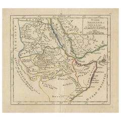
View AllOriginal Antique Map of Arabia and the Red Sea
Located in Langweer, NL
Antique map titled 'Carte de la Coste d'Arabie (..) - Kaart van de Kust van Arabië (..)'. This is a Dutch version, engraved by J. van Schley, of Bellin's map of Arabia and the Red Sea...
Category
Antique Mid-18th Century Maps
Materials
Paper

Antique Engraved Map of the Northern Part of Greece and the Aegean Sea, Ca.1730
Located in Langweer, NL
Title: "GRÆCIÆ PARS Septentrionalis".
Hand Coloured Engraved map by G. Delisle of the northern part of the Aegean. In the top left corner a distance scale included.
Condition...
Category
Antique 1730s Maps
Materials
Paper
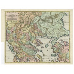
$599 Sale Price
20% Off
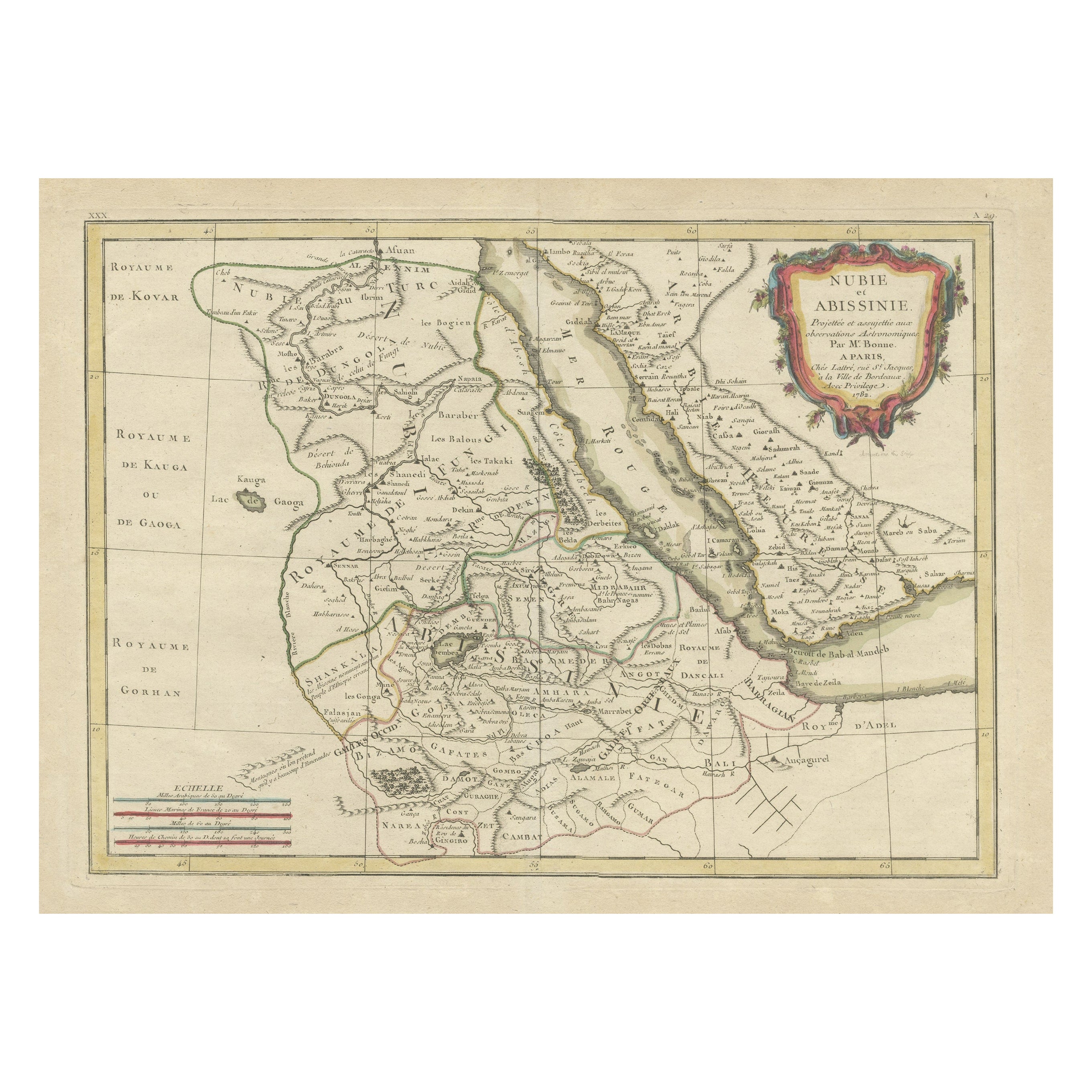
Antique Map of Arabia including Nubia and Abyssinia, also shows the Red Sea
Located in Langweer, NL
Antique map titled 'Nubie et Abissinie'. Original antique map of Nubia, a region along the Nile river, and Abyssinia or the Ethiopian Empire. This map o...
Category
Antique Late 18th Century Maps
Materials
Paper
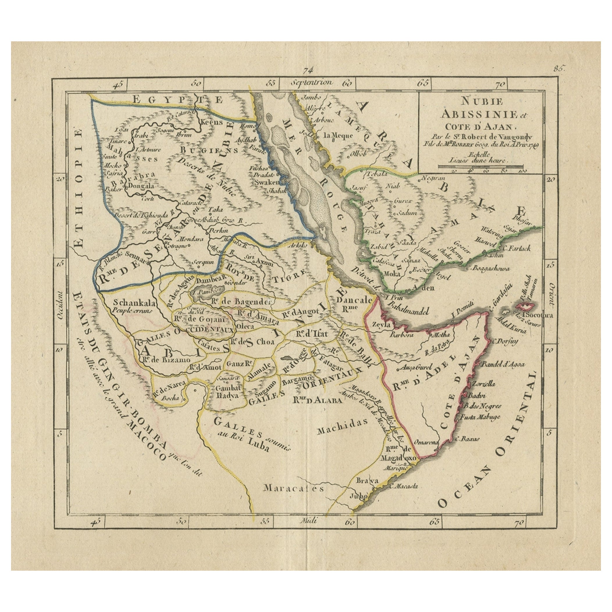
Original Antique Map of Abyssinia, Sudan and the Red Sea, 1749
Located in Langweer, NL
Antique map titled 'Nubie, Abissinie et Cote d'Ajan'.
Map of Abyssinia, Sudan and the Red Sea by Robert Vaugondy. Covers from Arabia and Egypt south to M...
Category
Antique 1740s Maps
Materials
Paper
Original Antique Engraved Map of the Russian Empire, 1778
Located in Langweer, NL
Description: Antique map titled 'A New and Correct Map of the Russian Empire'.
Original antique map of the Russian Empire. This map originates from Moore's 'New and Complete Coll...
Category
Antique 1770s Maps
Materials
Paper

$507 Sale Price
20% Off
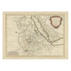
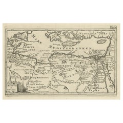
Original Antique Map of the Region Between the Gulf of Lybia and the Red Sea
Located in Langweer, NL
Original antique map titled 'Aegyptus et Cyrene'. Detailed ancient map of the region between the Gulf of Lybia and the Red Sea, with marvelous detail along the Mediterranean Coastline and the Nile, Egypt. This map originates from 'Philippi Cluveri Introductionis in universam geographiam (..)' by P. Clüver. Published 1729.
Philipp Clüver was an Early Modern German geographer and historian. Cluver's Geography was one of the most enduring works of the 17th & 18th Centuries, issued by several different publishers with many different sets of maps...
Category
Antique Early 18th Century Maps
Materials
Paper
You May Also Like
Original Antique Map of Sweden, Engraved by Barlow, 1806
Located in St Annes, Lancashire
Great map of Sweden
Copper-plate engraving by Barlow
Published by Brightly & Kinnersly, Bungay, Suffolk. 1806
Unframed.
Category
Antique Early 1800s English Maps
Materials
Paper

Original Antique Map of Switzerland, Engraved By Barlow, Dated 1807
Located in St Annes, Lancashire
Great map of Switzerland
Copper-plate engraving by Barlow
Published by Brightly & Kinnersly, Bungay, Suffolk.
Dated 1807
Unframed.
Category
Antique Early 1800s English Maps
Materials
Paper

Original Antique Map of The World by Thomas Clerk, 1817
Located in St Annes, Lancashire
Great map of The Eastern and Western Hemispheres
On 2 sheets
Copper-plate engraving
Drawn and engraved by Thomas Clerk, Edinburgh.
Published by Mackenzie And Dent, 1817
...
Category
Antique 1810s English Maps
Materials
Paper

Original Antique Map of Europe, Arrowsmith, 1820
Located in St Annes, Lancashire
Great map of Europe
Drawn under the direction of Arrowsmith.
Copper-plate engraving.
Published by Longman, Hurst, Rees, Orme and Brown, 1820
...
Category
Antique 1820s English Maps
Materials
Paper

Original Antique Map of Ireland- Kerry. C.1840
Located in St Annes, Lancashire
Great map of Kerry
Steel engraving
Drawn under the direction of A.Adlard
Published by How and Parsons, C.1840
Unframed.
Category
Antique 1840s English Maps
Materials
Paper

Original Antique Map of South America. C.1780
Located in St Annes, Lancashire
Great map of South America
Copper-plate engraving
Published C.1780
Two small worm holes to left side of map
Unframed.
Category
Antique Early 1800s English Georgian Maps
Materials
Paper

Recently Viewed
View AllMore Ways To Browse
Maps Tallis
Relief Map
Railroad And Indian
Antique Macedonia
Antique Maps Southeast Asia
Map Of Ancient Greece
Antique Railroad Collectibles
Cartographer Tool
Hungary Map
Large Map Of Italy
Antique Map Of Poland
Antique Railroad Maps
Antique Surveying Level
Island Plantation
Map 1901
Sri Lanka Map
Used Marine Compass
Antique Furniture Columbus