Items Similar to 1854 Map of Massachusetts, Connecticut and Rhode Island, Antique Wall Map


Want more images or videos?
Request additional images or videos from the seller
1 of 5
1854 Map of Massachusetts, Connecticut and Rhode Island, Antique Wall Map
About the Item
This striking wall map was published in 1854 by Ensign, Bridgman & Fanning and has both full original hand-coloring and original hardware. This impression is both informative and highly decorative.
The states are divided into counties, outlined in red, green, and black, and subdivided into towns. Roads, canals, and railroad lines are prominently depicted, although they are not all labeled. The mapmakers also marked lighthouses, banks, churches, and prominent buildings, with a key at right. The map is an informative and comprehensive overview of the infrastructural development of New England prior to the Civil War. Physical geographies depicted include elevation, conveyed with hachure marks, rivers and lakes. The impression features an inset map of Boston at upper right, and a Map of the Eastern States and New York at bottom.
Edward Hooker Ensign (August 18, 1818 - July 10, 1871) was an American map and print publisher based in New York during the middle part of the 19th century. Ensign was born in West Hartland, Connecticut. Little is known of Ensign's training; he inherited his business from his father, Timothy Ensign, who was a map publisher active in New York. Ensign seems to have had a flair for partnerships and throughout his career published with Humphrey Phelps, Horace Thayer, Thomas Fanning, and Erastus Bridgeman, among others. His various imprints include 'Phelps and Ensign' (1841-1844), 'T. and E. H. Ensign' (1844-1848), 'Ensign and Thayer' (1849), 'Ensign, Thayer, and Company' (1850-1851), 'Horace Thayer and Company' (1852), and 'Ensign, Bridgman and Fanning' (1854-1863). At least some of these companies maintained offices in both Buffalo and New York City.
This map has been mounted onto archival linen. Additionally, the map is attached to its original hanging hardware and is presented using the very finest archival materials and techniques, in a custom-built frame. Framed dimensions: 38 1/4" H x 45 1/4" W x 2 1/2" D.
- Dimensions:Height: 38.13 in (96.86 cm)Width: 45 in (114.3 cm)Depth: 3.5 in (8.89 cm)
- Materials and Techniques:
- Place of Origin:
- Period:
- Date of Manufacture:1854
- Condition:Additions or alterations made to the original: Mounted onto new archival linen in 2014. Wear consistent with age and use.
- Seller Location:Colorado Springs, CO
- Reference Number:
About the Seller
4.9
Platinum Seller
These expertly vetted sellers are 1stDibs' most experienced sellers and are rated highest by our customers.
Established in 2010
1stDibs seller since 2011
400 sales on 1stDibs
Typical response time: <1 hour
- ShippingRetrieving quote...Ships From: Colorado Springs, CO
- Return PolicyA return for this item may be initiated within 10 days of delivery.
More From This SellerView All
- 1907 Map of Colorado, Antique Topographical Map, by Louis NellLocated in Colorado Springs, COThis highly detailed pocket map is a topographical map of the state of Colorado by Louis Nell from 1907. The map "has been complied from all availabl...Category
Antique Early 1900s American Maps
MaterialsPaper
- 1861 Topographical Map of the District of Columbia, by Boschke, Antique MapLocated in Colorado Springs, COPresented is an original map of Albert Boschke's extremely sought-after "Topographical Map of the District of Columbia Surveyed in the Years 1856 ...Category
Antique 1860s American Historical Memorabilia
MaterialsPaper
- 1847 “World at One View” Antique Hand-Colored Wall Map of the WorldLocated in Colorado Springs, COThis is a highly desirable hanging wall map of the "World at One View", published in 1847 by Ensign and Thayer, New York. This pictorial map was printed as a broadside and features...Category
Antique 19th Century American Maps
MaterialsPaper
- 1864 Map of North America, Antique Hand-Colored Map, by Adolphe Hippolyte DufourLocated in Colorado Springs, COOffered is a map of North America entitled Amerique du Nord from 1864. This rare, separately published wall map was produced by Adolphe Hippolyte Dufour. This map includes vibrant an...Category
Antique 1860s French Maps
MaterialsPaper
- "The United States from the Latest Authorities" Antique Wall Map, 1835Located in Colorado Springs, COThis is a 1835 map of “The United States from the Latest Authorities” by Ezra Strong. A hand-colored engraved wall map of the eastern half of the United States, this map has a large inset of the "Oregon District" and several engraved city views and two portraits. The primary map extends to Mexico Texas and the Missouri Territory, showing the course of the Missouri River to Ft. Mandan and Old Ft. Mandan, and noting many forts along the river. The territories to the east of Missouri Territory are separately delineated as Sioux District and Huron District. The western details of the map are very good for a map of this time period, with many Native American settlements, villages, forts and other details noted. The map is bordered with vignettes of Boston, New York, Philadelphia, Hartford, Cincinnati, and Baltimore. Each vignette notes the date settled, primary settler, and the population as of 1830. Two portraits of LaFayette and George Washington are presented in full length with related biographical information. A large inset map at lower right shows the Oregon District, centered on the Columbia River and extending to the Rocky Mountains. This is one of the earliest commercial appearances of a separate map of Oregon...Category
Antique 1830s American Maps
MaterialsPaper
- 1847 Antique Map of Mexico, Texas and California by Samuel Augustus MitchellBy Samuel Augustus Mitchell 1Located in Colorado Springs, COPresented is the second edition of Samuel Augustus Mitchell's Map of Mexico, Including Yucatan & Upper California, an important map showing the progress of the Mexican-American War. ...Category
Antique 1840s American Maps
MaterialsPaper


You May Also Like
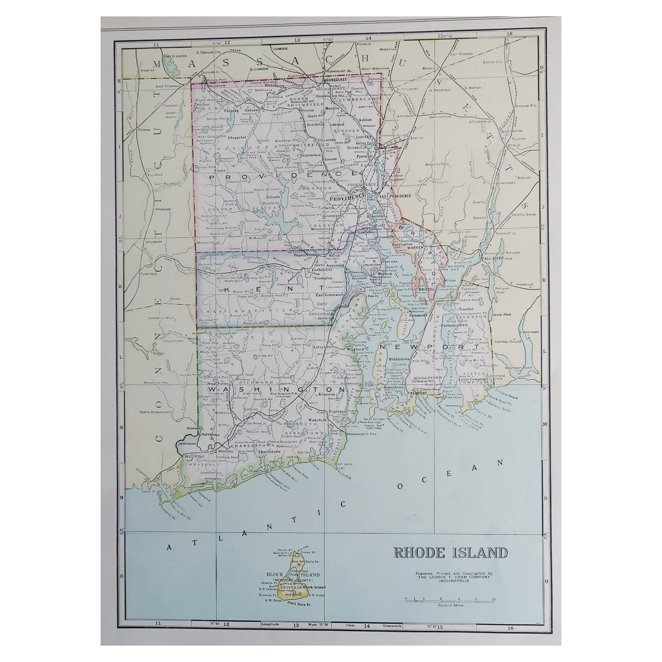
- Large Original Antique Map of Rhode Island, USA, C.1900Located in St Annes, LancashireFabulous map of Rhode Island Original color Engraved and printed by the George F. Cram Company, Indianapolis. Published, C.1900 Unframed Free ...Category
Antique 1890s American Maps
MaterialsPaper
- Antique Map of Scotland With an Inset Map of the Shetland Islands, 1854Located in Langweer, NLStunning Map of Scotland that will look beautiful in any setting framed on the wall. Description: Large Antique map titled 'Scotland with its Islands, drawn from the Topographical surveys...Category
Antique 1850s Maps
MaterialsPaper
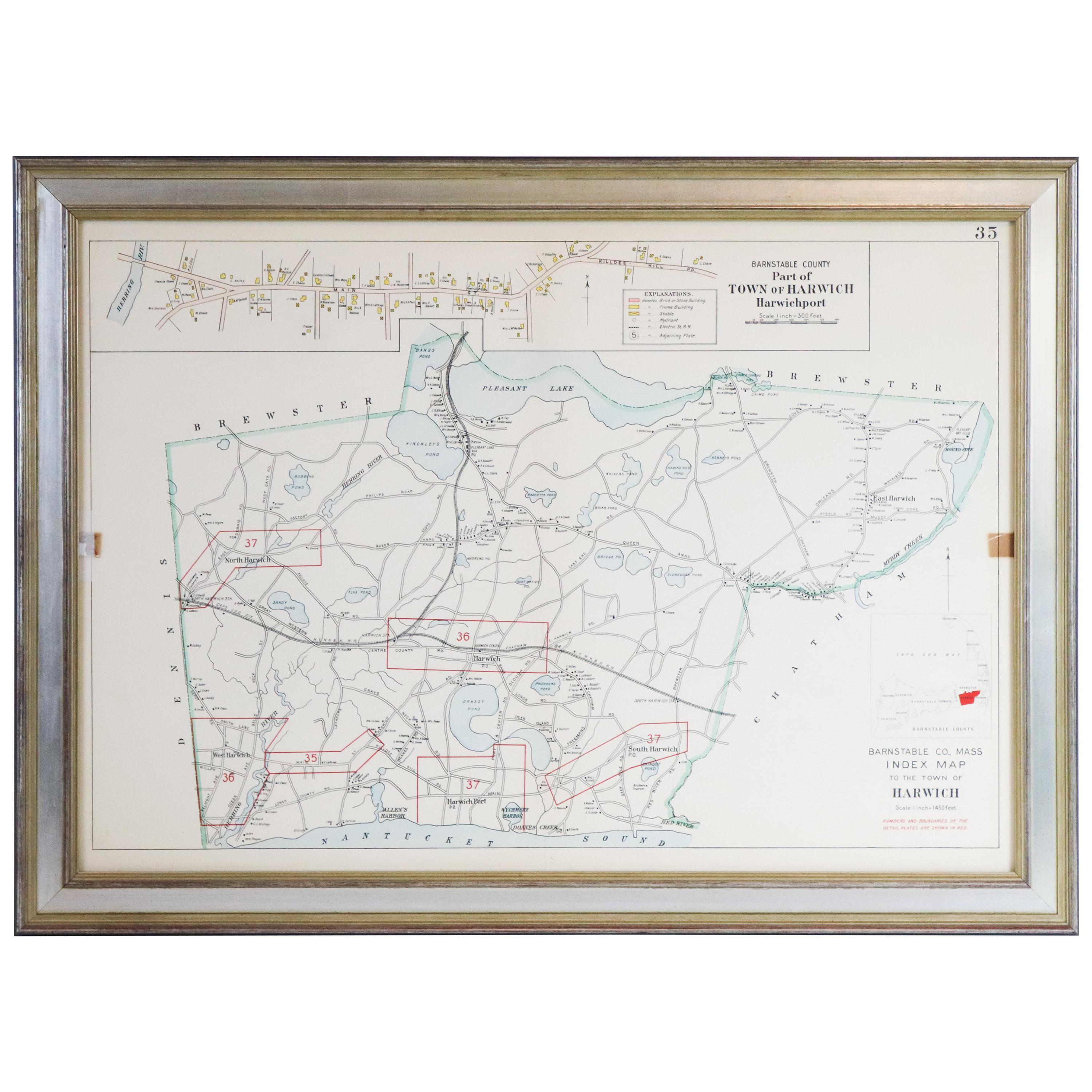
- Map of Harwich, MassachusettsLocated in Norwell, MATurn of the century map of Harwich, Massachusetts. Plate from a Cape Cod County Map book showing the Barnstable county town of Harwich including Allens Harbor, Pleasant Lake, Harwich...Category
20th Century Maps
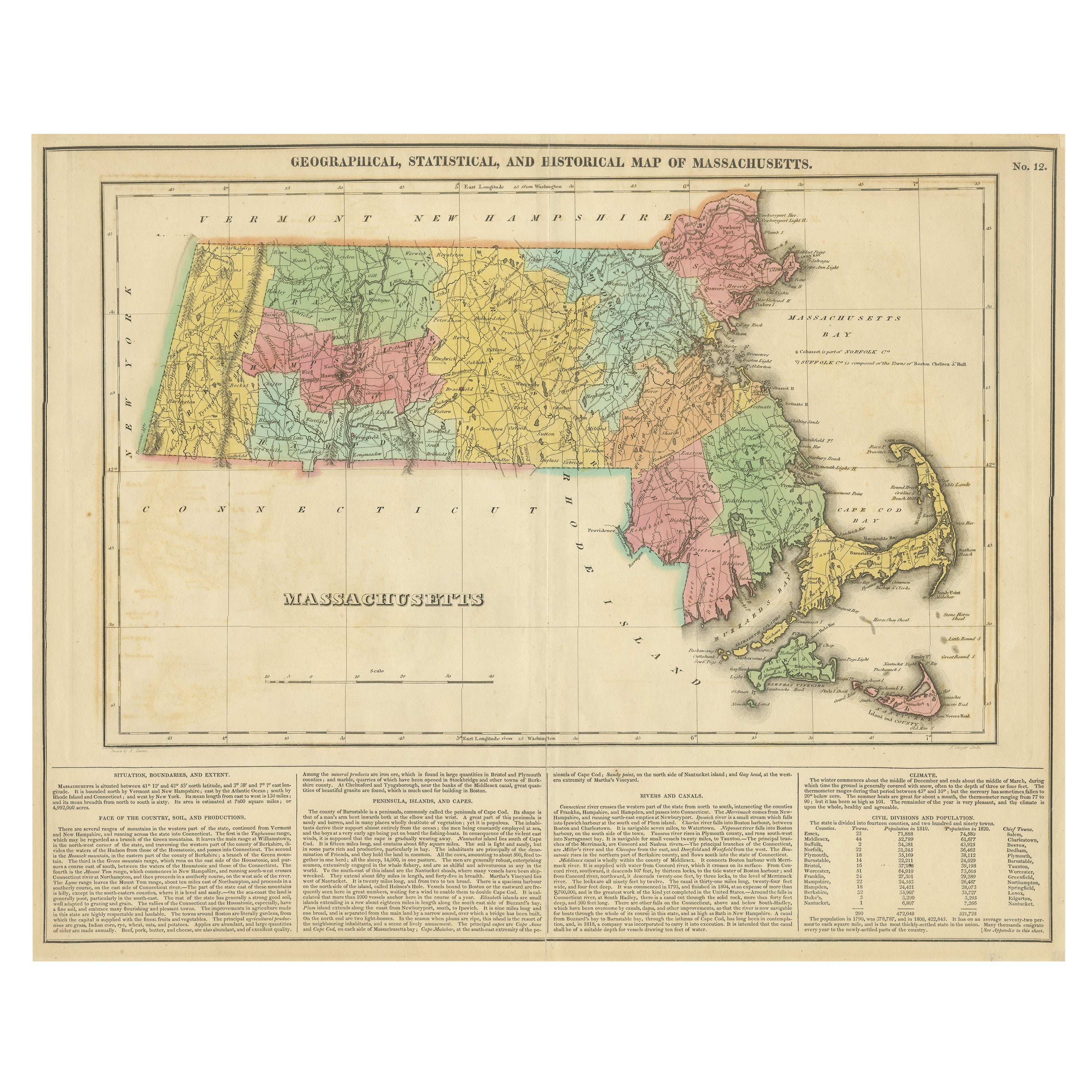
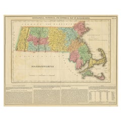
- Antique Geographical, Historical and Statistical Map of Massachusetts, 1822Located in Langweer, NLThis attractive map of Massachusetts presents a finely detailed overview of the state in the first quarter of the 19th century. Transportation ...Category
Antique 1820s Maps
MaterialsPaper
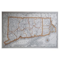
- Large Original Antique Map of Connecticut, USA, 1894By Rand McNally & Co.Located in St Annes, LancashireFabulous map of Connecticut and Rhode Island Original color By Rand, McNally & Co. Published, 1894 Unframed Free shipping.Category
Antique 1890s American Maps
MaterialsPaper
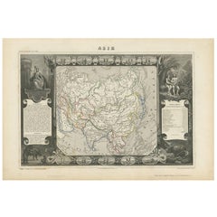
- Antique Map of Asia by V. Levasseur, 1854By Victor LevasseurLocated in Langweer, NLAntique map titled 'Asie'. Map of the main Asian continent. The decorated border shows various images, as well as two blocks of statistical text on the continent, including populatio...Category
Antique Mid-19th Century Maps
MaterialsPaper


Recently Viewed
View AllMore Ways To Browse
Furniture Connecticut
Antique Prints Maps
Antique Maps Prints
Antique Map Prints
Antique Map Print
Antique Maps And Prints
Antique Prints And Maps
Map 19th Century
Massachusetts Used Furniture
Massachusetts Furniture
Map Wall
Connecticut Used Furniture
Map Of Itsly
United States Map
Prints Of Antique Maps
Map Of United States
The United States Map
Map York