Items Similar to Antique Map of the Russian Empire by R. Bonne, 1780


Want more images or videos?
Request additional images or videos from the seller
1 of 10
Antique Map of the Russian Empire by R. Bonne, 1780
$167.39
£123.92
€140
CA$231.62
A$255.36
CHF 133.59
MX$3,132.75
NOK 1,681.69
SEK 1,572.64
DKK 1,066.43
About the Item
Antique map titled 'Carte de l'Empire de Russie.' Drawn by R. Bonne for G. Raynal’s Atlas de Toutes les Parties Connues du Globe Terrestre, Dressé pour l'Histoire Philosophique et Politique des Établissemens et du Commerce des Européens dans les Deux Indes.
- Dimensions:Height: 10.24 in (26 cm)Width: 15.01 in (38.1 cm)Depth: 0.02 in (0.5 mm)
- Materials and Techniques:Paper,Engraved
- Place of Origin:
- Period:
- Date of Manufacture:1780
- Condition:Minor fading. Please study image carefully.
- Seller Location:Langweer, NL
- Reference Number:Seller: BGI-007181stDibs: LU305439920891
About the Seller
5.0
Recognized Seller
These prestigious sellers are industry leaders and represent the highest echelon for item quality and design.
Platinum Seller
Premium sellers with a 4.7+ rating and 24-hour response times
Established in 2009
1stDibs seller since 2017
2,609 sales on 1stDibs
Typical response time: <1 hour
- ShippingRetrieving quote...Shipping from: Langweer, Netherlands
- Return Policy
Authenticity Guarantee
In the unlikely event there’s an issue with an item’s authenticity, contact us within 1 year for a full refund. DetailsMoney-Back Guarantee
If your item is not as described, is damaged in transit, or does not arrive, contact us within 7 days for a full refund. Details24-Hour Cancellation
You have a 24-hour grace period in which to reconsider your purchase, with no questions asked.Vetted Professional Sellers
Our world-class sellers must adhere to strict standards for service and quality, maintaining the integrity of our listings.Price-Match Guarantee
If you find that a seller listed the same item for a lower price elsewhere, we’ll match it.Trusted Global Delivery
Our best-in-class carrier network provides specialized shipping options worldwide, including custom delivery.More From This Seller
View AllAntique Map of Western Tartary and the Gobi Desert of the Russian Empire, c.1750
Located in Langweer, NL
Antique map titled 'A Map of Western Tartary Drawn from the Survey of the Jesuits and Mr. Kyrillow's Map of the Russian Empire'. Map of the Gobi Desert and the eastern portion of the...
Category
Antique 18th Century Maps
Materials
Paper

$334 Sale Price
20% Off
Antique Map of Russia in Europe by T. Kitchin, circa 1770
Located in Langweer, NL
Antique map titled 'Russia or Moscovy in Europe, drawn from the latest authorities (..)'. An interesting and attractive early 19th century map of Russia in Europe which was engraved ...
Category
Antique Late 18th Century Maps
Materials
Paper

$153 Sale Price
20% Off
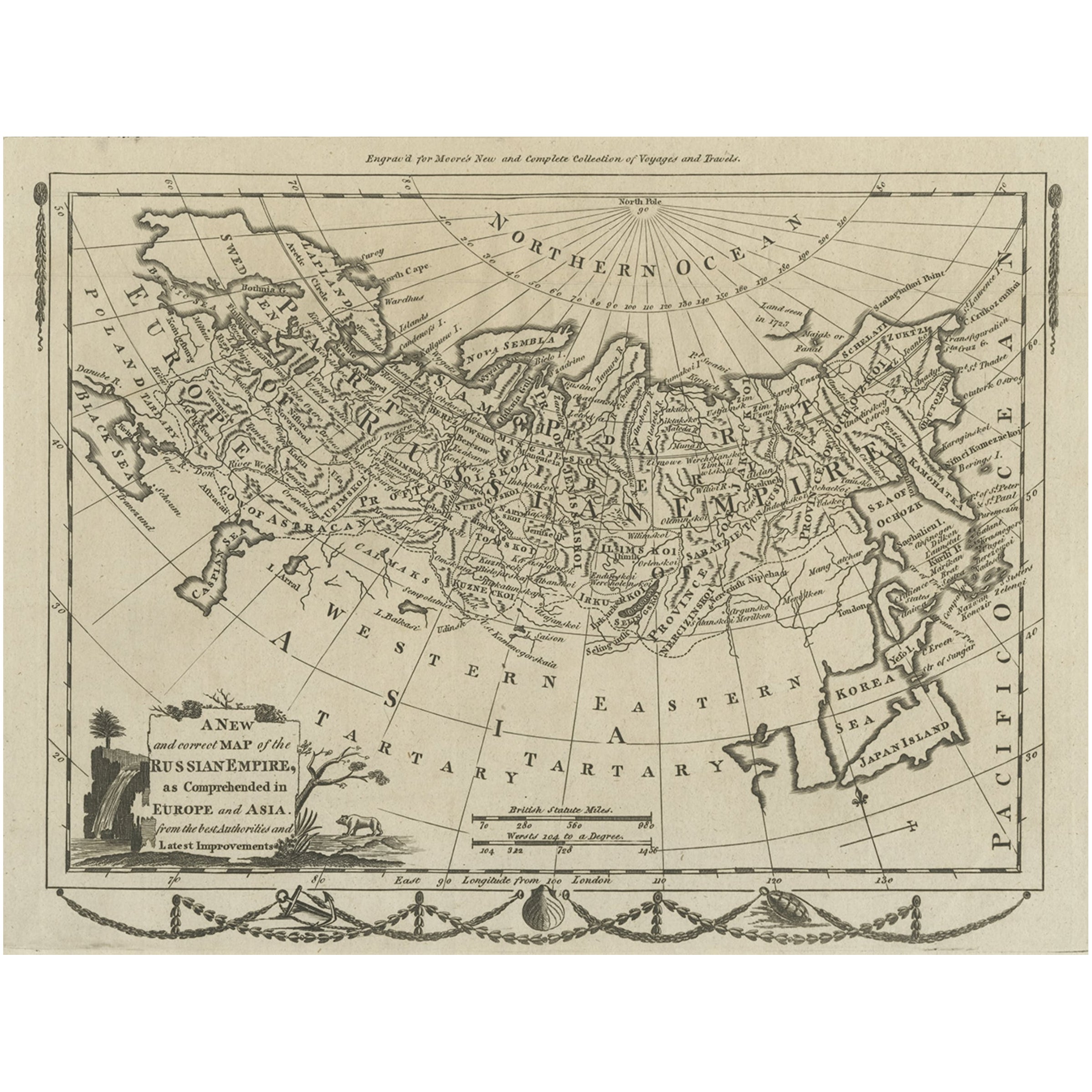
Original Antique Engraved Map of the Russian Empire, 1778
Located in Langweer, NL
Description: Antique map titled 'A New and Correct Map of the Russian Empire'.
Original antique map of the Russian Empire. This map originates from Moore's 'New and Complete Coll...
Category
Antique 1770s Maps
Materials
Paper
$526 Sale Price
20% Off
Antique Map of the Russian Empire in Europe by Vaugondy, 1750
Located in Langweer, NL
Antique map titled 'Partie Occidentale de l'Empire de Russie (..)'. Detailed map of the western part of Russia, extending south to the Caspian and east to Irkurkoy and Ilimskoy.
A...
Category
Antique 18th Century Maps
Materials
Paper

$325 Sale Price
20% Off
Antique Map of North and East Asia, 1751
Located in Langweer, NL
Map 2: 'Carte des parties nord et est de L'Asie'. (Map of the Northern parts and East Asia.) Five maps on one sheet, showing California, Alaska and Siberia, Korea and Japan. South to...
Category
Antique 18th Century French Maps
Materials
Paper

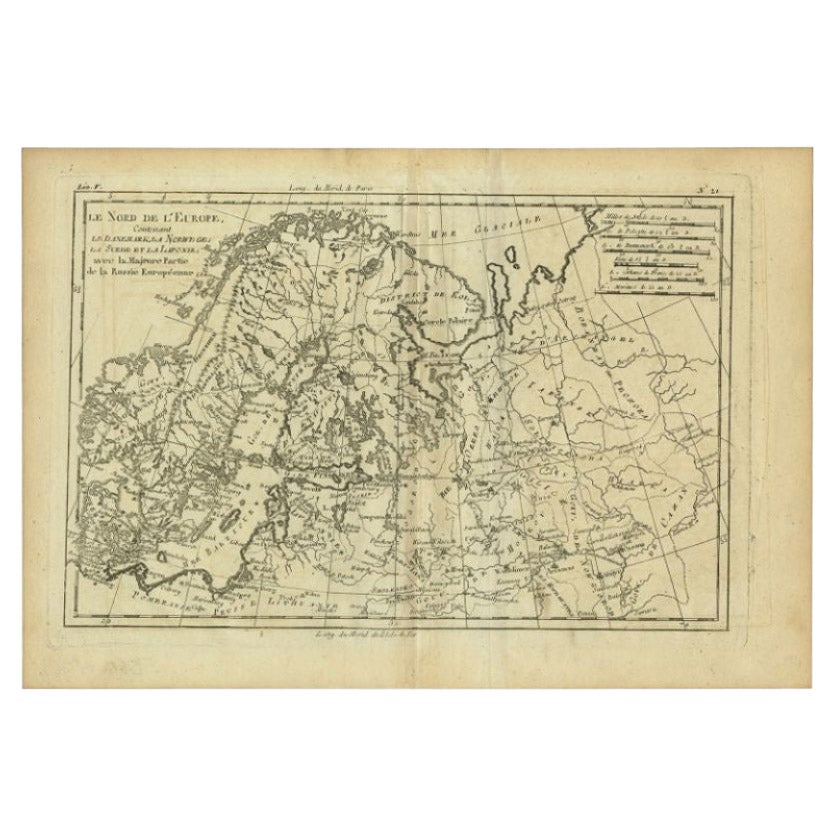
Antique Map of Northern Europe by Bonne, c.1780
Located in Langweer, NL
Antique map titled 'Le Nord de L'Europe, Contenant Le Danemark, La Norwege; La Suede et La Laponie avec la Majeure Partie de al Russie Europeenne.' Map of Northern Europe and Europea...
Category
Antique 18th Century French Maps
Materials
Paper
$112 Sale Price
30% Off
You May Also Like
1814 Map of "Russian Empire" Ric.r032
Located in Norton, MA
1814 Map of
"Russian Empire"
Ric.r032
Russian Empire. Description: This is an 1814 John Thomson map of the Russian Empire. The map depicts the region from the Baltic Sea, Prussia, and Sweden to the Aleutian Islands and from the Arctic Ocean to the Yellow River. Highly detailed, myriad cities, towns, and villages are labeled throughout, including St. Petersburg, Moscow, Minsk, Kiev, and Kharkov. Rivers and mountain ranges are also identified, as are islands and numerous locations along the coastlines. It is important to note that the long-disputed sea between Korea and Japan is identified as the 'Sea of Japan.
Historical Context:
In 1815, Tsarist Russia emerged from the Napoleonic Wars economically insolvent and politically fearful of the Revolutionary fervor that had just swept through Europe. In order to shore up Russia's economic position, the Tsars began an aggressive series of expansions into the Caucuses and Central Asia that would vastly increase the landmass of the Russian Empire.
Publication History
Thomson maps are known for their stunning color, awe inspiring size, and magnificent detail. Thomson's work, including this map, represents some of the finest cartographic art...
Category
Antique 19th Century Unknown Maps
Materials
Paper

Large1852 Map "Russian Empire" Ric.r0011
Located in Norton, MA
Large
1852 map "Russian Empire"
George Phillips & Son 1852
Ric.r0011
Dimension: Paper: 67 cm W x 52 cm H ; Sight: 60cm W x 50 cm H
Condition: Good Condition with aged tonin...
Category
Antique 19th Century Unknown Maps
Materials
Paper

1860 Large Map "Carte De La Siberie Russie D'asie, " Ric.R0001
Located in Norton, MA
Large 1860 map "Carte De La Siberie Russie D'Asie," R-0001
" Authentic" - 1860 map "Carte De La Siberie Russie D'Asie,"
Dimension: Paper: 68 cm W x 51 cm H ; Sight: 51cm W x 4...
Category
Antique 19th Century Unknown Maps
Materials
Paper

1790 Thomas Stackhouse Map, Entitled "Russia in Europe, " , Ric.a004
Located in Norton, MA
1790 Thomas Stackhouse map, entitled
"Russia in Europe"
Ric.a004
Stackhouse, Thomas
Russia in Europe [map]
London: T. Stackhouse, 1783. Map. Matted hand-colored copper engraving. Image size: 14.5 x 15.25 inches. Mat size: 22.75 x 23.75 inches. A beautiful example of this map of Eastern Europe...
Category
Antique 17th Century Unknown Maps
Materials
Paper

Von Reilly Map of the Russian Empire, 1796
Located in Savannah, GA
A map of the Russian Empire in Europe by Von Reilly. Published in Vienna, 1796.
32 inches wide by 24 ½ inches tall
Category
Antique 1790s Austrian Prints
Materials
Glass, Wood, Paper

Original Antique Map of Europe, Arrowsmith, 1820
Located in St Annes, Lancashire
Great map of Europe
Drawn under the direction of Arrowsmith.
Copper-plate engraving.
Published by Longman, Hurst, Rees, Orme and Brown, 1820
...
Category
Antique 1820s English Maps
Materials
Paper

More Ways To Browse
Oak Chairs With Arms
Mahogany Corner Table
Persian Gabbeh Rugs
Round Side Table With Glass Top
1949 Dining Room Set
Baluch Rugs
Italy Metal Wall Decorations
Silver Cup Set
Swedish Weavings
Vintage Netherlands
Antique Vanity Furniture
Danish Stainless Steel
High Back Italy Dining Chairs
Iron Scroll Table
Italian Velvet Living Room Sets
New York Marble Table
Silver Mid Century Ice Bucket
Solid Wood Side Table Stool