Items Similar to Antique Map of St. Jago, St Mayo and Praya Harbour, Mauritania, Africa, c.1750


Want more images or videos?
Request additional images or videos from the seller
1 of 5
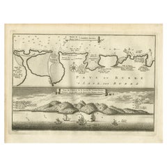
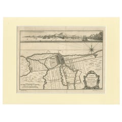
Antique Map of St. Jago, St Mayo and Praya Harbour, Mauritania, Africa, c.1750
About the Item
Antique map Africa titled 'Gezigt van 't Eiland St. Jago en de Stad St. Jago of Ribeyro Grande, Haven van Praya in 't Eiland St. Jago'. To the left, two views of the island and city of St. Jago. To the right, the harbour of Praya, St. Jago, Mauritania. Artists and Engravers: Jakob van der Schley (1715-1779) was a Dutch draughtsman and engraver, who studied under Bernard Picart.
Artist: Jakob van der Schley (1715-1779) was a Dutch draughtsman and engraver, who studied under Bernard Picart.
Condition: Very good, general age-related toning. Please study image carefully.
Date: c.1750
Overall size: 25 x 20 cm.
Image size: 20.5 x 14.5 cm.
Antique prints have long been appreciated for both their aesthetic and investment value. They were the product of engraved, etched or lithographed plates. These plates were handmade out of wood or metal, which required an incredible level of skill, patience and craftsmanship. Whether you have a house with Victorian furniture or more contemporary decor an old engraving can enhance your living space.
- Dimensions:Height: 7.88 in (20 cm)Width: 9.85 in (25 cm)Depth: 0 in (0.01 mm)
- Materials and Techniques:
- Period:
- Date of Manufacture:circa 1750
- Condition:Condition: Very good, general age-related toning. Please study image carefully.
- Seller Location:Langweer, NL
- Reference Number:
About the Seller
5.0
Platinum Seller
These expertly vetted sellers are 1stDibs' most experienced sellers and are rated highest by our customers.
Established in 2009
1stDibs seller since 2017
1,922 sales on 1stDibs
Typical response time: <1 hour
- ShippingRetrieving quote...Ships From: Langweer, Netherlands
- Return PolicyA return for this item may be initiated within 14 days of delivery.
More From This SellerView All
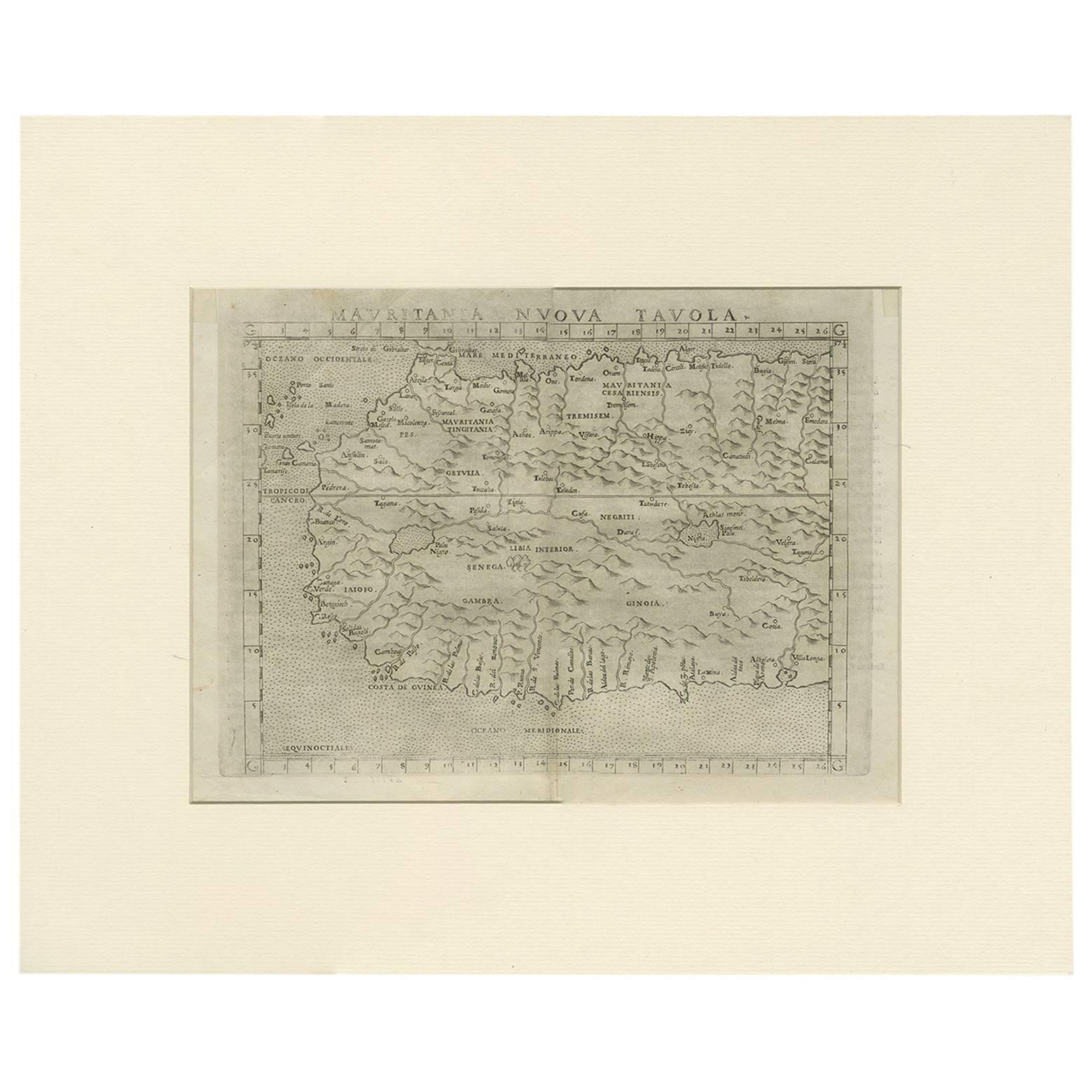
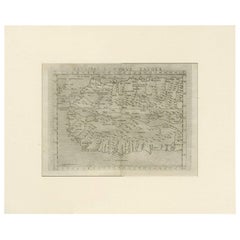
- Antique Map of Mauritania 'Africa' by G. Ruscelli, 1574Located in Langweer, NLA very rare mid-16th century black and white map of North and West Africa called Mauritania by the Italian cartographic editor Girolamo Ruscelli. T...Category
Antique 16th Century Maps
MaterialsPaper
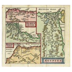
- Antique Map of North Africa showing Egypt, Mauritania and Africa Minor, 1672Located in Langweer, NLAntique map titled 'Africa Minor, Mauritania , Aegyptus.' Charming miniature map of North Africa, showing Egypt, Mauritania and Africa Minor. This map originates from the pocket atla...Category
Antique 17th Century Maps
MaterialsPaper
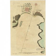
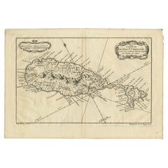
- Antique Map of the Harbour of Praia, Santiago Island, Cape Verde, c.1750Located in Langweer, NLAntique map titled 'A Draught of ye Harbour of Praya in the Island St. Jago (..)'. Uncommon map showing the harbour of Praia on Santiago Island, Cape Verde. Source unknown, to be det...Category
Antique 18th Century Maps
MaterialsPaper
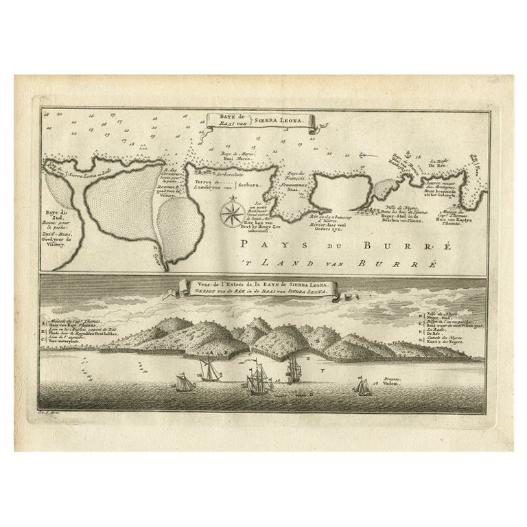
- Antique Map and View of the Bay of Sierra Leone in Africa, C.1750Located in Langweer, NLAntique print titled 'Baye de Sierra Leona (..) - Baai van Sierra Leona (..)'. Map and view of the bay of Sierra Leone. This print originates from 'Historische beschryving der Reizen...Category
Antique 18th Century Prints
MaterialsPaper
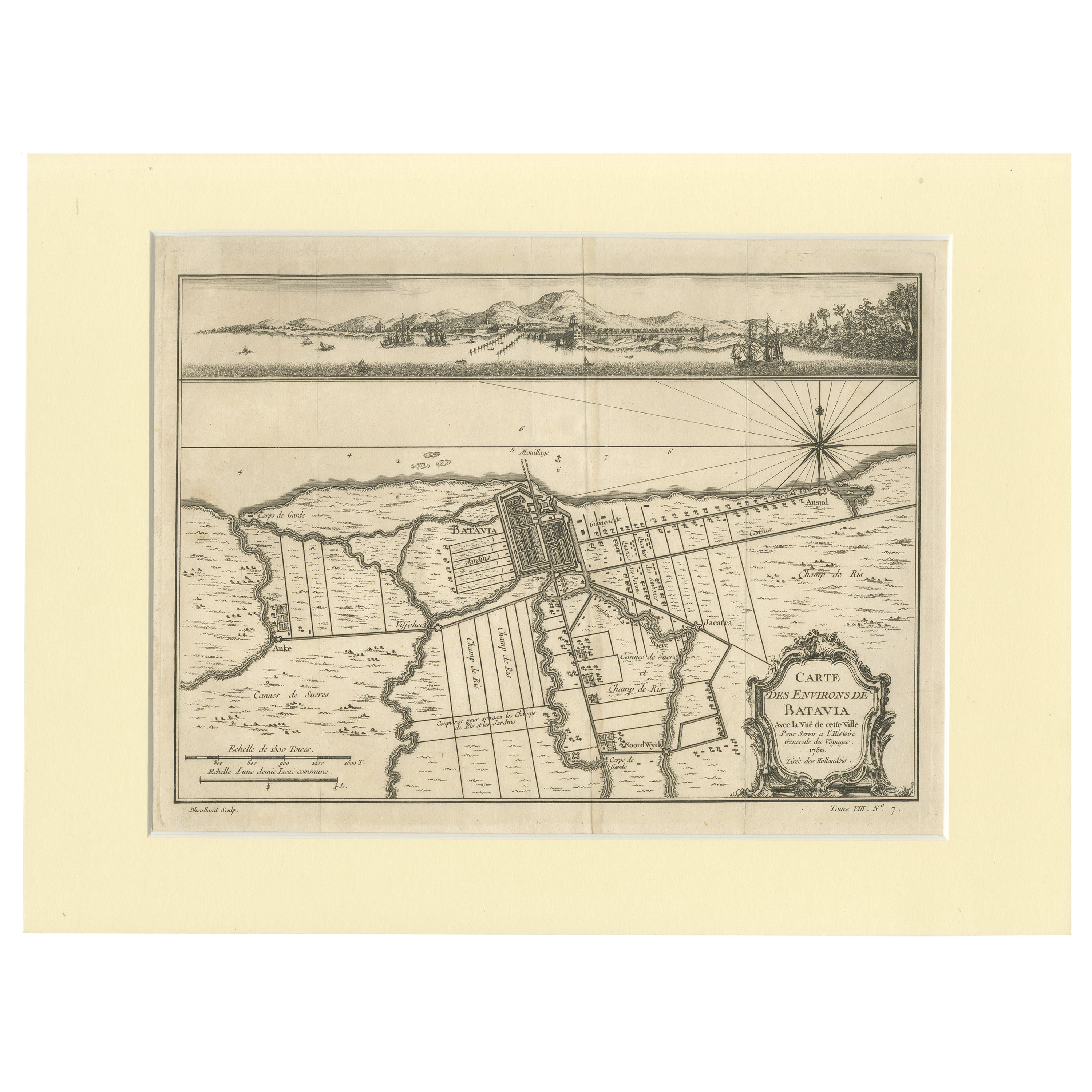
- Old Engraving of Batavia 'Jakarta, Indonesia' with Map and Harbour View, 1750Located in Langweer, NLAntique map titled 'Carte des environs de Batavia '. French map of the Batavia area (Jakarta) in Indonesia. With cartouche, scale and compass rose. Published circa 1750. The map i...Category
Antique 1750s Maps
MaterialsPaper
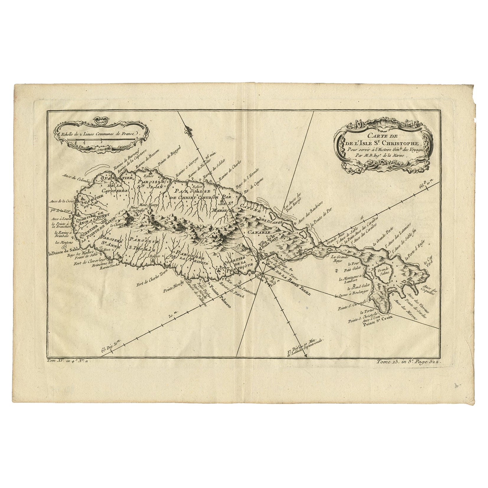
- Antique Map of the Caribbean Island of St Kitts, ca.1750Located in Langweer, NLDescription: Antique map titled 'Carte de l'Isle St. Christophe pour Servir a l'Histoire Genle. des Voyages.' Detailed map of the Island of St. Kitts, showing the Parishes, towns, ...Category
Antique 1750s Maps
MaterialsPaper
You May Also Like
- Original Antique Map of South Africa, Arrowsmith, 1820Located in St Annes, LancashireGreat map of South Africa. Drawn under the direction of Arrowsmith. Copper-plate engraving. Published by Longman, Hurst, Rees, Orme and Br...Category
Antique 1820s English Maps
MaterialsPaper
- Antique Lithography Map, West Africa, English, Framed, Cartography, VictorianLocated in Hele, Devon, GBThis is an antique lithography map of Western Africa. An English, framed atlas engraving of cartographic interest by John Rapkin, dating to the early Victorian period and later, circ...Category
Antique Mid-19th Century British Early Victorian Maps
MaterialsWood
- London 1744 Published Watercolour Antique Map of East Africa by Eman BowenLocated in GBWe are delighted to offer for sale this New and Accurate Map of Nubia & Abissinia, together with all the Kingdoms Tributary Thereto, and bordering upon them published in 1744 by Emanuel Bowen This is a decorative antique engraved map of East Africa...Category
Antique 1740s English George III Maps
MaterialsPaper
- 1854 Map of Massachusetts, Connecticut and Rhode Island, Antique Wall MapLocated in Colorado Springs, COThis striking wall map was published in 1854 by Ensign, Bridgman & Fanning and has both full original hand-coloring and original hardware. This impression is both informative and highly decorative. The states are divided into counties, outlined in red, green, and black, and subdivided into towns. Roads, canals, and railroad lines are prominently depicted, although they are not all labeled. The mapmakers also marked lighthouses, banks, churches, and prominent buildings, with a key at right. The map is an informative and comprehensive overview of the infrastructural development of New England prior to the Civil War. Physical geographies depicted include elevation, conveyed with hachure marks, rivers and lakes. The impression features an inset map of Boston...Category
Antique 19th Century American Maps
MaterialsPaper
- Antique Map of Principality of MonacoBy Antonio Vallardi EditoreLocated in Alessandria, PiemonteST/619 - "Old Geographical Atlas of Italy - Topographic map of ex-Principality of Monaco" - ediz Vallardi - Milano - A somewhat special edition ---Category
Antique Late 19th Century Italian Other Prints
MaterialsPaper
- Large University Chart “Physical Map of Africa” by BaconLocated in Chillerton, Isle of WightLarge university chart “Physical Map of Africa” by Bacon W&A K Johnston’s Charts of Physical Maps By G W Bacon, This is colorful Physical map of North America, it is large lithograph set...Category
Early 20th Century Folk Art Posters
MaterialsLinen


Recently Viewed
View AllMore Ways To Browse
18th Century African
St Bernard
African Plate
Grande Date
Map Of Long Island
Maps Of Long Island
Victorian African
Lithograph City Maps
City Map Lithograph
Bernard T
Dutch Harbour
Antique Long Island Map
Antique Maps Of Long Island
Antique Map Of Long Island
Antique Map Long Island
Rare Compass
Map Of United Kingdom
Antique Presentation Plates