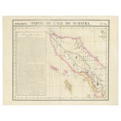
Items Similar to Antique Map of Sumatra by Tardieu, 1811


Want more images or videos?
Request additional images or videos from the seller
1 of 5
Antique Map of Sumatra by Tardieu, 1811
$224.78
$280.9720% Off
£166.40
£20820% Off
€188
€23520% Off
CA$311.03
CA$388.7920% Off
A$342.91
A$428.6320% Off
CHF 179.40
CHF 224.2520% Off
MX$4,206.84
MX$5,258.5420% Off
NOK 2,258.27
NOK 2,822.8320% Off
SEK 2,111.84
SEK 2,639.7920% Off
DKK 1,432.07
DKK 1,790.0920% Off
About the Item
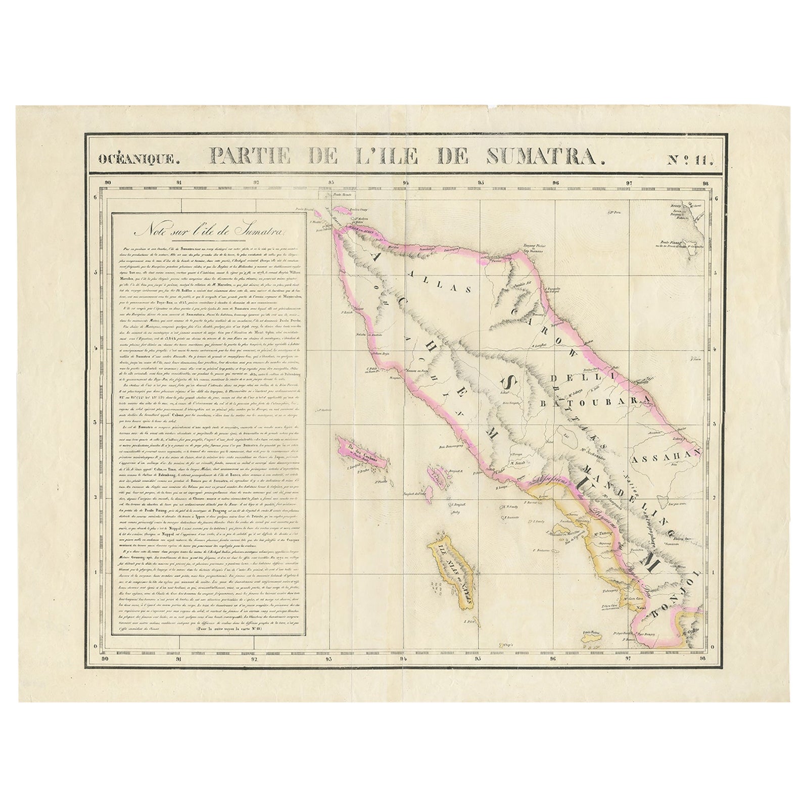
Antique map Sumatra titled 'Partie de l'Isle Sumatra'. Part of the Island of Sumatra, where the English settlement of the Bay of Sellabar near Bencoute can be found. Originates from 'Voyage aux Indes Orientales, pendant les annees'. Artists and Engravers: Engraved by Tardieu. Published by A. Bertrand, Paris.
Artist: Engraved by Tardieu. Published by A. Bertrand, Paris.
Condition: Good, general age-related toning. Some tears along the folding lines, please study image carefully.
Date: 1811
Overall size: 40.5 x 53 cm.
Image size: 0.001 x 38 x 43 cm.
Antique prints have long been appreciated for both their aesthetic and investment value. They were the product of engraved, etched or lithographed plates. These plates were handmade out of wood or metal, which required an incredible level of skill, patience and craftsmanship. Whether you have a house with Victorian furniture or more contemporary decor an old engraving can enhance your living space. We offer a wide range of authentic antique prints for any budget.
- Dimensions:Height: 20.87 in (53 cm)Width: 15.95 in (40.5 cm)Depth: 0 in (0.01 mm)
- Materials and Techniques:
- Period:
- Date of Manufacture:1811
- Condition:
- Seller Location:Langweer, NL
- Reference Number:Seller: BGJC-002391stDibs: LU3054327771792
About the Seller
5.0
Recognized Seller
These prestigious sellers are industry leaders and represent the highest echelon for item quality and design.
Platinum Seller
Premium sellers with a 4.7+ rating and 24-hour response times
Established in 2009
1stDibs seller since 2017
2,613 sales on 1stDibs
Typical response time: <1 hour
- ShippingRetrieving quote...Shipping from: Langweer, Netherlands
- Return Policy
Authenticity Guarantee
In the unlikely event there’s an issue with an item’s authenticity, contact us within 1 year for a full refund. DetailsMoney-Back Guarantee
If your item is not as described, is damaged in transit, or does not arrive, contact us within 7 days for a full refund. Details24-Hour Cancellation
You have a 24-hour grace period in which to reconsider your purchase, with no questions asked.Vetted Professional Sellers
Our world-class sellers must adhere to strict standards for service and quality, maintaining the integrity of our listings.Price-Match Guarantee
If you find that a seller listed the same item for a lower price elsewhere, we’ll match it.Trusted Global Delivery
Our best-in-class carrier network provides specialized shipping options worldwide, including custom delivery.More From This Seller
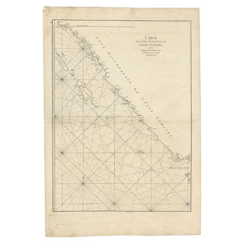
View AllAntique Map of the South-Western Coast of Sumatra by De la Haye, c.1780
Located in Langweer, NL
Antique map titled 'Carte de la Côte Occidentale de l'Isle Sumatra'. Sea chart of the part of the south-western coast of Sumatra with the Nassau (Nias) and Fortune isles.
Artists ...
Category
Antique 18th Century Maps
Materials
Paper
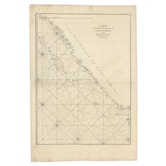
$387 Sale Price
20% Off
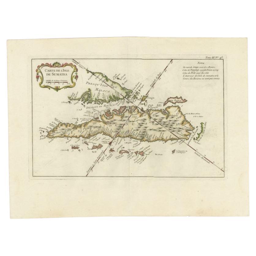
Antique Map of Sumatra by Bellin, 1764
Located in Langweer, NL
Antique map Sumatra titled 'Carte de l'Isle de Sumatra'. Old map of Sumatra, Malaysia and the Straits of Malacca, including Singapore. This map originates ...
Category
Antique 18th Century Maps
Materials
Paper

$463 Sale Price
20% Off
Antique Coastal Map of Sumatra by De La Haye, circa 1780
Located in Langweer, NL
Antique map titled 'Carte de la Côte Occidentale de l'Isle Sumatra'. Sea chart of the part of the south-western coast of Sumatra with the Nassau (Nias) and Fortune isles. Engraved by...
Category
Antique Late 18th Century French Maps
Materials
Paper
$382 Sale Price
20% Off
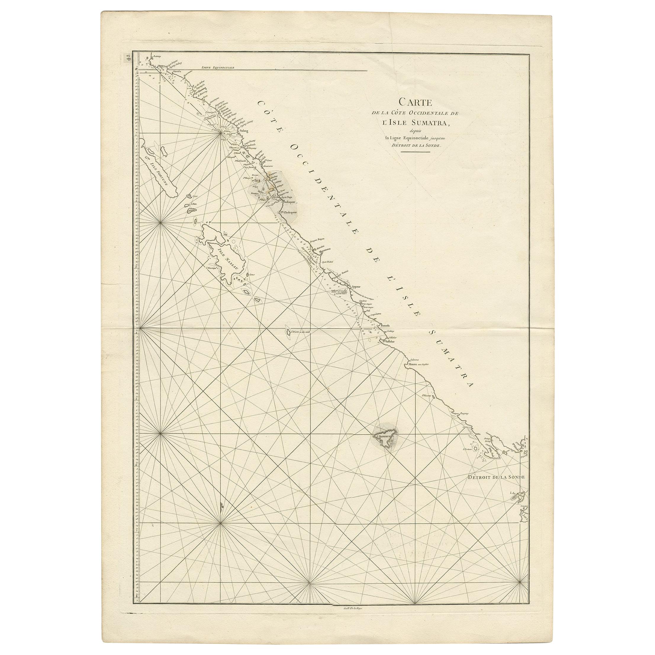
Antique Coastal Map of West Sumatra 'Indonesia' by J. Mannevillette, 1745
Located in Langweer, NL
Antique map titled 'Carte de la côte occidentale de l'isle Sumatra depuis la ligne équinoctiale jusqu'au détroit de la Sonde'. Beautiful coastal map of We...
Category
Antique Mid-18th Century Maps
Materials
Paper
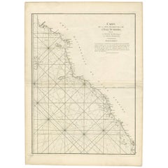
$473 Sale Price
20% Off
Detailed Antique Map of Northern Sumatra, Indonesia, circa 1825
Located in Langweer, NL
Antique map titled 'Partie de l'Ile de Sumatra'. Chart showing the northern part of Sumatra. Originates from 'Atlas Universel' by P.M. Vandermaelen.
Artists and Engravers: Philip...
Category
Antique 19th Century Maps
Materials
Paper
$401 Sale Price
20% Off
Antique Map of Indonesia by C.F. Beautemps-Beaupre, circa 1807
Located in Langweer, NL
Antique map titled 'Carte de la partie du grand archipel d'Asie'. Map of Indonesia showing tracks of Recherche and Esperance in 1792-1793. This map is...
Category
Antique Early 19th Century Maps
Materials
Paper

$717 Sale Price
20% Off
You May Also Like
Antique French Map of Asia Including China Indoneseia India, 1783
Located in Amsterdam, Noord Holland
Very nice map of Asia. 1783 Dedie au Roy.
Additional information:
Country of Manufacturing: Europe
Period: 18th century Qing (1661 - 1912)
Condition: Overall Condition B (Good Used)...
Category
Antique 18th Century European Maps
Materials
Paper

$648 Sale Price
20% Off
Original Antique Map of South East Asia by Thomas Clerk, 1817
Located in St Annes, Lancashire
Great map of South East Asia
Copper-plate engraving
Drawn and engraved by Thomas Clerk, Edinburgh.
Published by Mackenzie And Dent, 1817
Unframed.
Category
Antique 1810s English Maps
Materials
Paper

Antique 1803 Italian Map of Asia Including China Indoneseia India
Located in Amsterdam, Noord Holland
Antique 1803 Italian Map of Asia Including China Indoneseia India
Very nice map of Asia. 1803.
Additional information:
Type: Map
Country of Manufacturing: Europe
Period: 19th centu...
Category
Antique 19th Century European Maps
Materials
Paper

$584 Sale Price
20% Off
Large Original Antique Map of Java and Borneo, Fullarton, C.1870
Located in St Annes, Lancashire
Great map of Java and Borneo
Wonderful figurative borders
From the celebrated Royal Illustrated Atlas
Lithograph. Original color.
Published by Fullarton, Edinburgh. C.1870
Unfr...
Category
Antique 1870s Scottish Maps
Materials
Paper

Antique Map of California as an Island "The 5 Californias" by Robert de Vaugondy
Located in San Diego, CA
A very nice and rare antique map entitled "Carte de la Californie Suivant" (The 5 Californias), by Didier Robert de Vaugondy of Paris, circa 1772. The map itself measures 15.5" x 13...
Category
Antique Mid-19th Century American Maps
Materials
Paper

Original Antique Map of South America. C.1780
Located in St Annes, Lancashire
Great map of South America
Copper-plate engraving
Published C.1780
Two small worm holes to left side of map
Unframed.
Category
Antique Early 1800s English Georgian Maps
Materials
Paper

More Ways To Browse
Patagonia Map
Sardinia Map
Antique Map Of Thailand
Antique Wooden Roller
Croatia Map
Map Of Native American Tribes
Marie Galante
Romania Map
Used Furniture Nova Scotia
18th Century Scottish Collectibles
Antique Furniture Northumberland
Antique Map Nova Scotia
Antique Map Palestine
California Island Map
Constantinople Map
Croatian Antiques
Ptolemy Map
Antique Maps Massachusetts