Items Similar to Antique Map the Windward or South Caribbean Islands and Guiana, 1859


Want more images or videos?
Request additional images or videos from the seller
1 of 5
Antique Map the Windward or South Caribbean Islands and Guiana, 1859
About the Item
Antique map titled 'The Windward or South Caribbean Islands'. Original antique map of South Caribbean Islands. This map originates from ‘The Imperial Atlas of Modern Geography’. Published by W. G. Blackie, 1859.
The Windward Islands, also known as the Islands of Barlovento, are the southern, generally larger islands of the Lesser Antilles. Part of the West Indies, they lie south of the Leeward Islands. The name was also used to refer to a British colony which existed between 1833 and 1960 and originally consisted of the islands of Grenada, Saint Lucia, Saint Vincent, and the Grenadines. Today these islands constitute three sovereign states. The island of Dominica, also today a sovereign state, was traditionally considered a part of the Leeward Islands until 1940, when it was transferred from the British Leeward Islands colony to the British Windward Islands.
French Guiana is an overseas department/region and single territorial collectivity of France on the northern Atlantic coast of South America in the Guianas. It borders Brazil to the east and south and Suriname to the west.
- Dimensions:Height: 14.57 in (37 cm)Width: 21.26 in (54 cm)Depth: 0.02 in (0.5 mm)
- Materials and Techniques:
- Period:
- Date of Manufacture:1859
- Condition:Wear consistent with age and use. General age-related toning. some foxing, Please study image carefully.
- Seller Location:Langweer, NL
- Reference Number:
About the Seller
5.0
Platinum Seller
These expertly vetted sellers are 1stDibs' most experienced sellers and are rated highest by our customers.
Established in 2009
1stDibs seller since 2017
1,947 sales on 1stDibs
Typical response time: <1 hour
- ShippingRetrieving quote...Ships From: Langweer, Netherlands
- Return PolicyA return for this item may be initiated within 14 days of delivery.
More From This SellerView All
- Detailed Antique Map of the Windward Islands in the CaribbeanBy Covens & MortierLocated in Langweer, NLAntique map titled 'Carte des Antilles Francoises et des Isles Voisines'. Original antique map of the French Antilles, covering an area stretching from Guadeloupe in the north to Gre...Category
Antique Early 18th Century Maps
MaterialsPaper
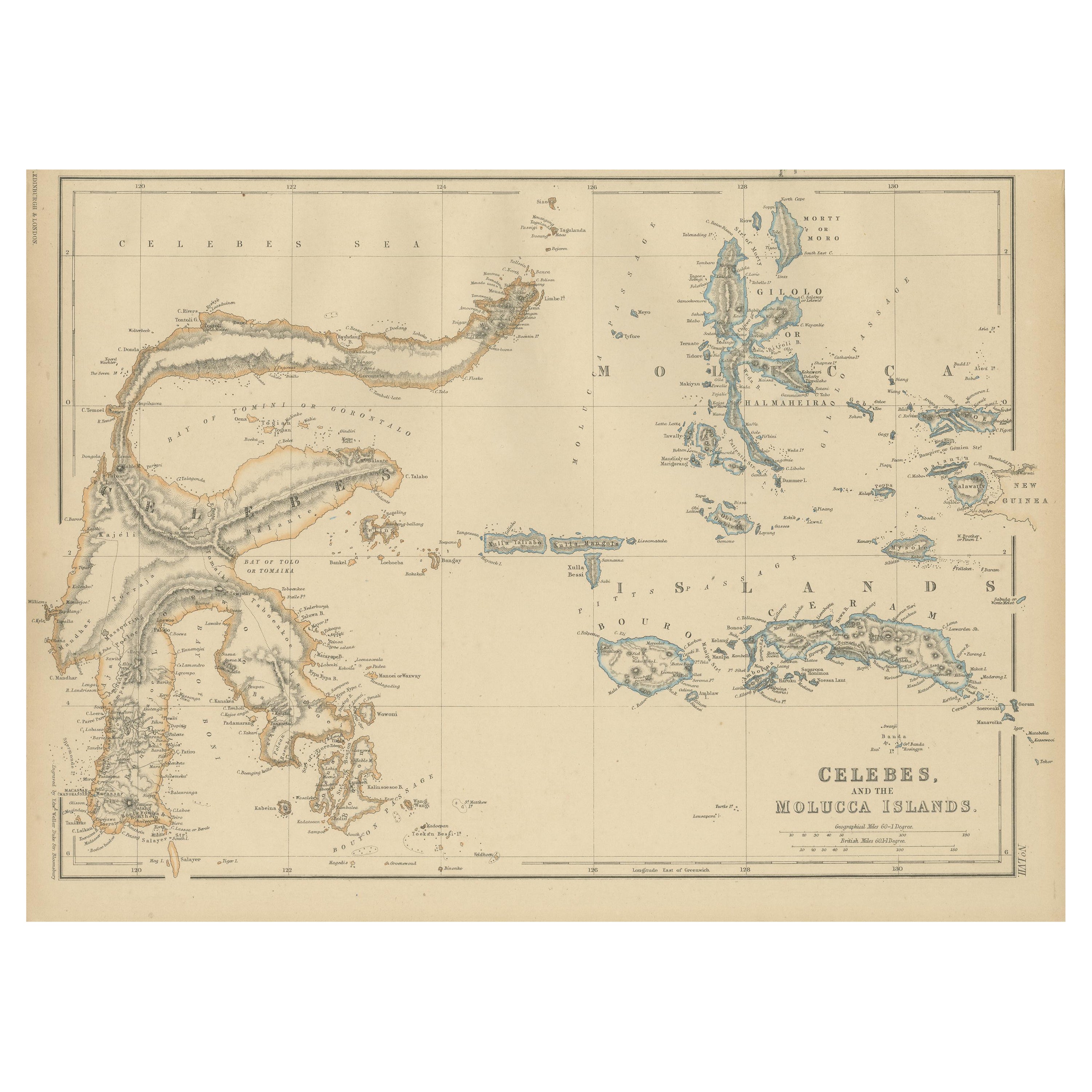
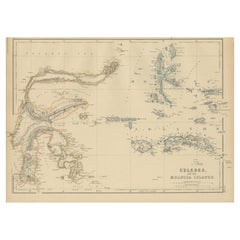
- Antique Map of Celebes and the Maluku Islands by W. G. Blackie, 1859Located in Langweer, NLAntique map titled 'Celebes and The Molucca Islands '. Original antique map of Celebes and the Maluku Islands (Moluccas). This map originates from ‘The Imperial Atlas of Modern Geogr...Category
Antique Mid-19th Century Maps
MaterialsPaper
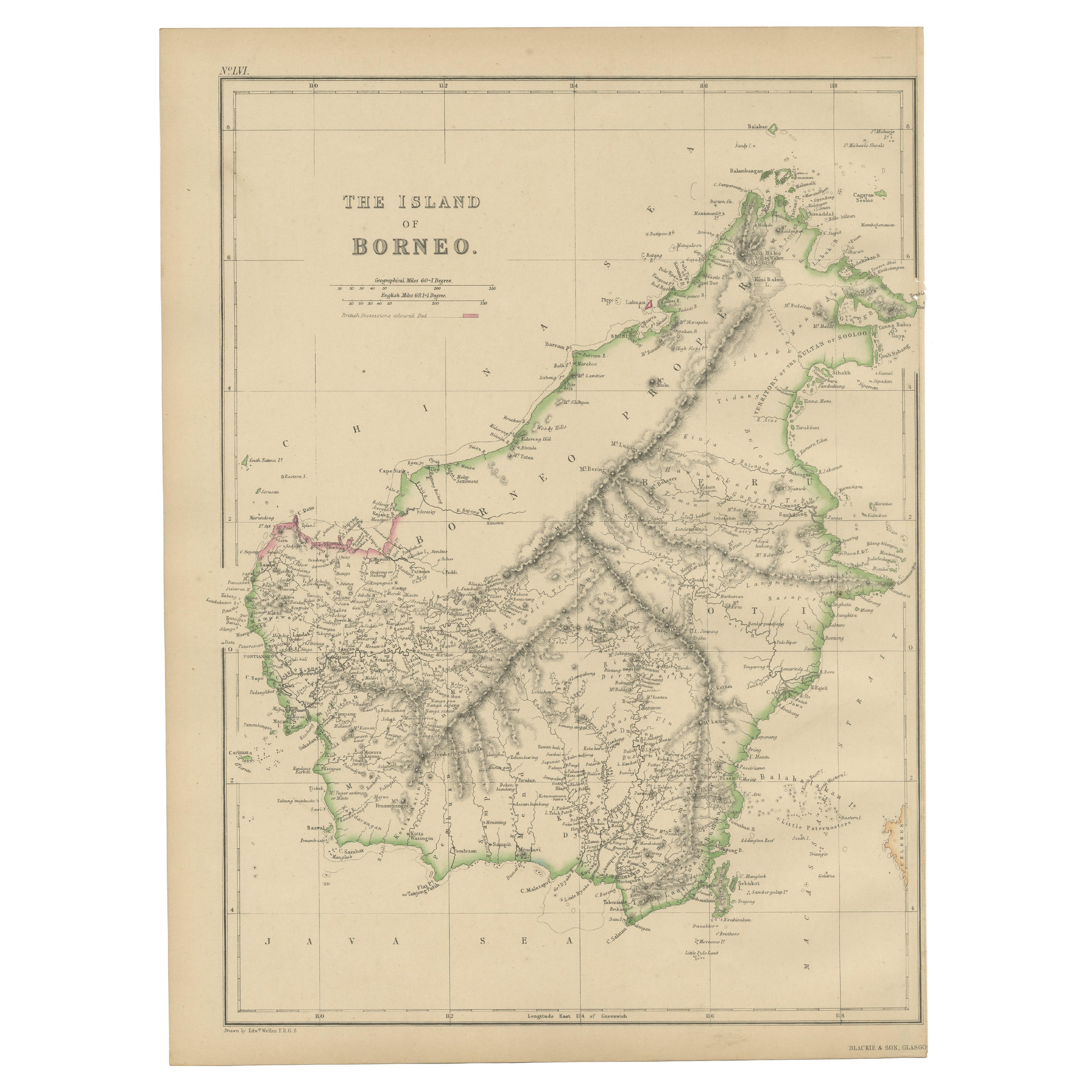
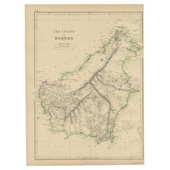
- Antique Map of the Island of Borneo by W. G. Blackie, 1859Located in Langweer, NLAntique map titled 'The Island of Borneo'. Original antique map of the Island of Borneo. This map originates from ‘The Imperial Atlas of Modern Geography’. Published by W. G. Blackie...Category
Antique Mid-19th Century Maps
MaterialsPaper
- Antique Map of South America by W. G. Blackie, 1859Located in Langweer, NLAntique map titled 'South America'. Original antique map of South America. This map originates from ‘The Imperial Atlas of Modern Geography’. Published by W. G. Blackie, 1859.Category
Antique Mid-19th Century Maps
MaterialsPaper
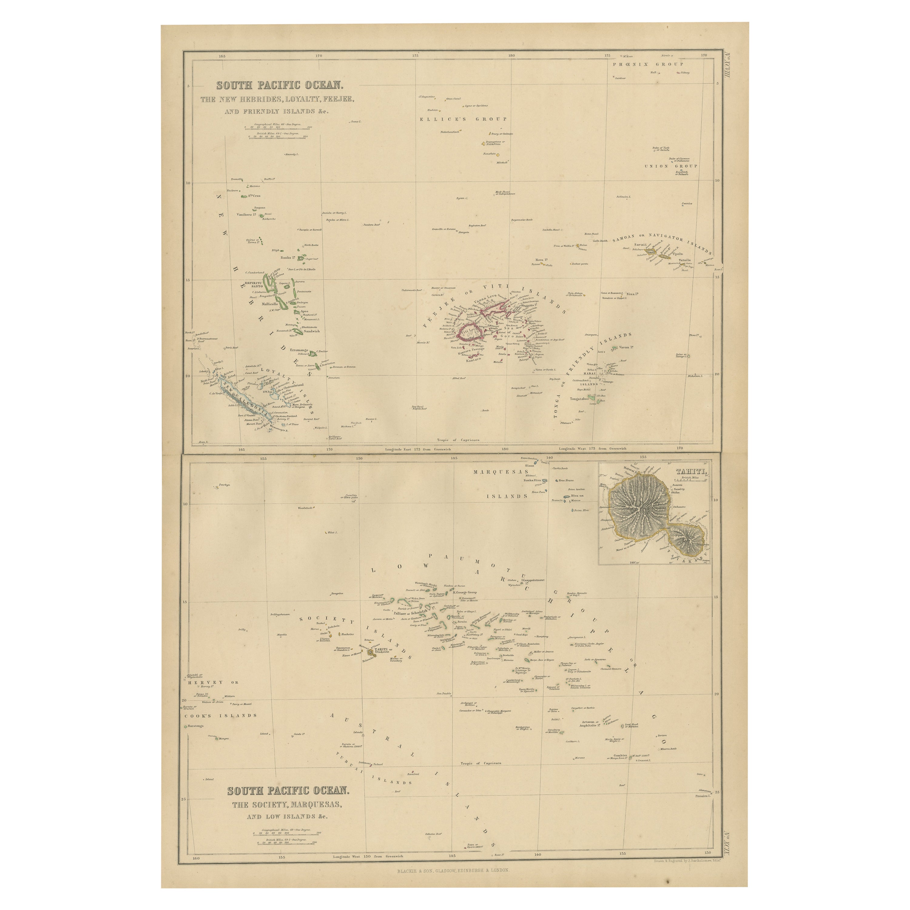
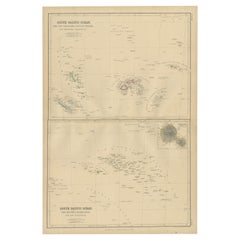
- Antique Map of South Pacific Ocean by W. G. Blackie, 1859Located in Langweer, NLAntique map titled 'South Pacific Ocean'. Original antique map of South Pacific Ocean with inset Map of Tahiti. This map originates from ‘The Imperial Atlas of Modern Geography’. Pub...Category
Antique Mid-19th Century Maps
MaterialsPaper
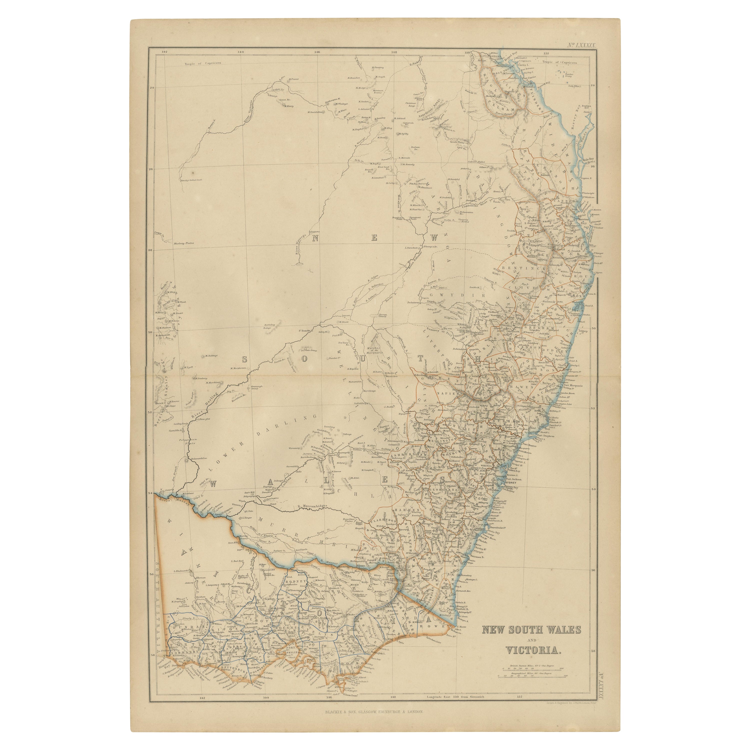
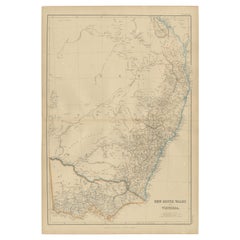
- Antique Map of New South Wales and Victoria by W. G. Blackie, 1859Located in Langweer, NLAntique map titled 'New South Wales and Victoria'. Original antique map of New South Wales and Victoria. This map originates from ‘The Imperial Atlas of Modern Geography’. Published ...Category
Antique Mid-19th Century Maps
MaterialsPaper


You May Also Like
- Large Antique 1859 Map of North AmericaLocated in Sag Harbor, NYThis Map was made by Augustus Mitchell in 1859 It is in amazing condition for being 163 years old. This price is for the rolled up easy to ship version of this piece. I will be Frami...Category
Antique Mid-19th Century American Maps
MaterialsCanvas, Paper

- Original Antique Map of South America. C.1780Located in St Annes, LancashireGreat map of South America Copper-plate engraving Published C.1780 Two small worm holes to left side of map Unframed.Category
Antique Early 1800s English Georgian Maps
MaterialsPaper
- Original Antique Map of South Africa, Arrowsmith, 1820Located in St Annes, LancashireGreat map of South Africa. Drawn under the direction of Arrowsmith. Copper-plate engraving. Published by Longman, Hurst, Rees, Orme and Br...Category
Antique 1820s English Maps
MaterialsPaper
- Original Antique Map of South America, circa 1830Located in St Annes, LancashireGreat map of South America Copper plate engraving Published by Butterworth, Livesey & Co., circa 1830 Unframed.Category
Antique Early 1800s English Other Maps
MaterialsPaper
- Hand-Colored 18th Century Homann Map of Denmark and Islands in the Baltic SeaBy Johann Baptist HomannLocated in Alamo, CAAn 18th century copper plate hand-colored map entitled "Insulae Danicae in Mari Balthico Sitae utpote Zeelandia, Fionia, Langelandia, Lalandia, Falstria, Fembria Mona" created by Joh...Category
Antique Early 18th Century German Maps
MaterialsPaper
- Original Antique Map of South East Asia by Becker, circa 1840Located in St Annes, LancashireGreat map of South East Asia Steel engraving with original color outline Engraved by Becker Published by Virtue, circa 1840. Unframed.Category
Antique 1840s English Other Maps
MaterialsPaper


Recently Viewed
View AllMore Ways To Browse
Antique Large Island
French Antique Island
Islands Of Caribbean
Mid Century Brazil Antiques
Map South America
Map Of South America
Antique State Maps
Mid Atlantic Furniture
French Map Of America
Map Of South Of France
Large 19th Century Maps
Antique Map Border
Antique British Maps
Antique Caribbean
Map Of American West
Antique Caribbean Furniture
West Indies Antiques
Antique Sovereigns