
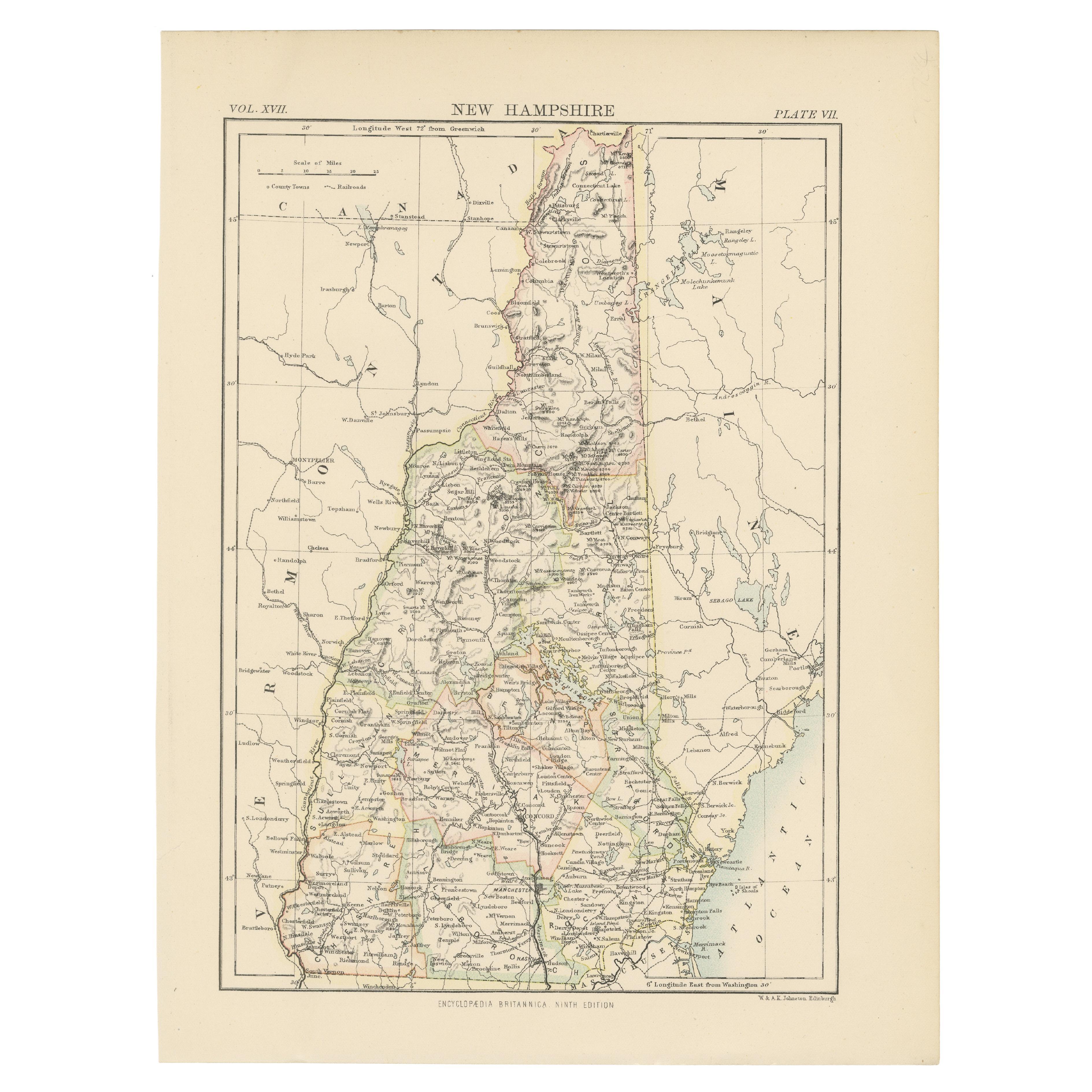
Antique "New Plan of London" Map by John Bartholomew, 1900
View Similar Items


Want more images or videos?
Request additional images or videos from the seller
1 of 10
Antique "New Plan of London" Map by John Bartholomew, 1900
About the Item
- Dimensions:Height: 32.5 in (82.55 cm)Width: 41.75 in (106.05 cm)Depth: 0.75 in (1.91 cm)
- Style:Victorian (Of the Period)
- Materials and Techniques:
- Place of Origin:
- Period:1900-1909
- Date of Manufacture:1900
- Condition:Wear consistent with age and use.
- Seller Location:Bridgeport, CT
- Reference Number:Seller: 1654111stDibs: LU1755223781392
About the Seller
5.0
Vetted Professional Seller
Every seller passes strict standards for authenticity and reliability
1stDibs seller since 2015
1,977 sales on 1stDibs
Authenticity Guarantee
In the unlikely event there’s an issue with an item’s authenticity, contact us within 1 year for a full refund. DetailsMoney-Back Guarantee
If your item is not as described, is damaged in transit, or does not arrive, contact us within 7 days for a full refund. Details24-Hour Cancellation
You have a 24-hour grace period in which to reconsider your purchase, with no questions asked.Vetted Professional Sellers
Our world-class sellers must adhere to strict standards for service and quality, maintaining the integrity of our listings.Price-Match Guarantee
If you find that a seller listed the same item for a lower price elsewhere, we’ll match it.Trusted Global Delivery
Our best-in-class carrier network provides specialized shipping options worldwide, including custom delivery.More From This Seller
View AllFramed 1731 Color Engraving, Map of Rotterdam by Matthaus Seutter, "Roterodami"
Located in Bridgeport, CT
"Roterodami". Seutter (1678-1757) was an important German 18th century map maker. Bird's eye view of the city above with full details, neoclassi...
Category
Antique 18th Century European Renaissance Maps
Materials
Glass, Wood, Paper

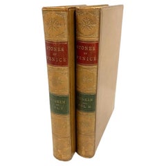
John Ruskin, The Stones Of Venice, Vols. I-II, 1880
Located in Bridgeport, CT
John Wiley & Sons, New York, 1880, illustrated. Tan leather with red, green and gilt spines. Marbled end papers, gilt edges. Volumes 1 and 2.
9 1/4" H x 6 3/8" D x 1 1/4"
Conditio...
Category
Antique 19th Century American Victorian Books
Materials
Leather, Paper
Matthaus Seutter, Framed 1730 Color Engraving Map of "Belgium Fonderatum"
Located in Bridgeport, CT
Label on verso. From Grosser Atlas. The name Belgium comes from the ancient designation "Gallis Belgica". Figural decoration upper left. M. Seutter was a famed German mapmaker in the...
Category
Antique 18th Century European Renaissance Maps
Materials
Brass

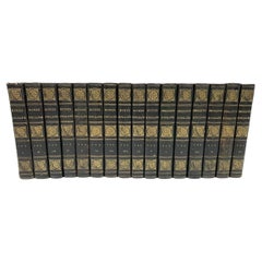
Horace Walpole, Anecdotes Of Painting In England, 5 Vols., London, 1826-28
Located in Bridgeport, CT
London, The Shakespeare Press for John Major and Robert Jennings, 5 Vol. set, 1828. Dark green leather with gilt. Gilt edges, red end papers, ribbon markers.
Each volume published on...
Category
Antique Early 19th Century English Georgian Books
Materials
Leather, Paper
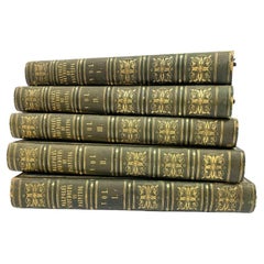
David Hume & T. Smollett, The History Of England, 16 Vols., London 1824
Located in Bridgeport, CT
London Stereotype Edition. Complete 16 vol. edition 1824. Black and gilt embossed leatherbound with marbled end papers and edges.
The set comprised of 10 volumes with Humes on spine...
Category
Antique Early 19th Century English Georgian Books
Materials
Leather, Paper
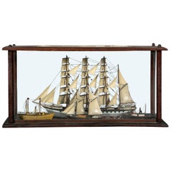
Antique Shadowbox Diorama of Ship Models
Located in Bridgeport, CT
An impressive and unusual 19th century cased ship diorama displaying four ships at sea. A four masted schooner sets the background with a tug boat, two masted vessel and a steamship ...
Category
Antique 19th Century American Classical Nautical Objects
Materials
Wood
You May Also Like
Antique Map of Northwest Africa by Bartholomew, 1922
Located in Langweer, NL
Antique map of Africa titled 'North-West Africa'. Old map of north-west Africa depicting Morocco, Algeria, Tunis and surroundings. This map originates from 'The Times' atlas. Artists...
Category
20th Century Maps
Materials
Paper
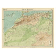
$88 Sale Price
20% Off
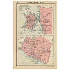
1908 John Bartholomew Miniature Map of Penang, Malacca, and Negri Sembilan
Located in Langweer, NL
1908 John Bartholomew Map of Penang, Malacca, and Negri Sembilan from Handy Atlas of Church and Empire
Description:
This finely detailed early twentieth-century map features two...
Category
Antique Early 1900s Maps
Materials
Paper
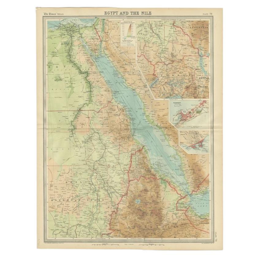
Antique Map of the Region of the Nile River by Bartholomew, 1922
Located in Langweer, NL
Antique map of Africa titled 'Egypt and the Nile'. Old map of Africa depicting Egypt, the Nile river and surroundings. This map originates from 'The Times' ...
Category
20th Century Maps
Materials
Paper
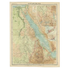
$88 Sale Price
20% Off
Antique Map of London by Tirion '1754'
Located in Langweer, NL
Antique map titled 'Kaart van Londen enz. en van het naby gelegen land ruim een Uur gaans rondsom dezelve Stad; getrokken uit de groote gemeeten Kaart van Hr. John Rocque'. In the se...
Category
Antique Mid-18th Century Maps
Materials
Paper

$741 Sale Price
20% Off
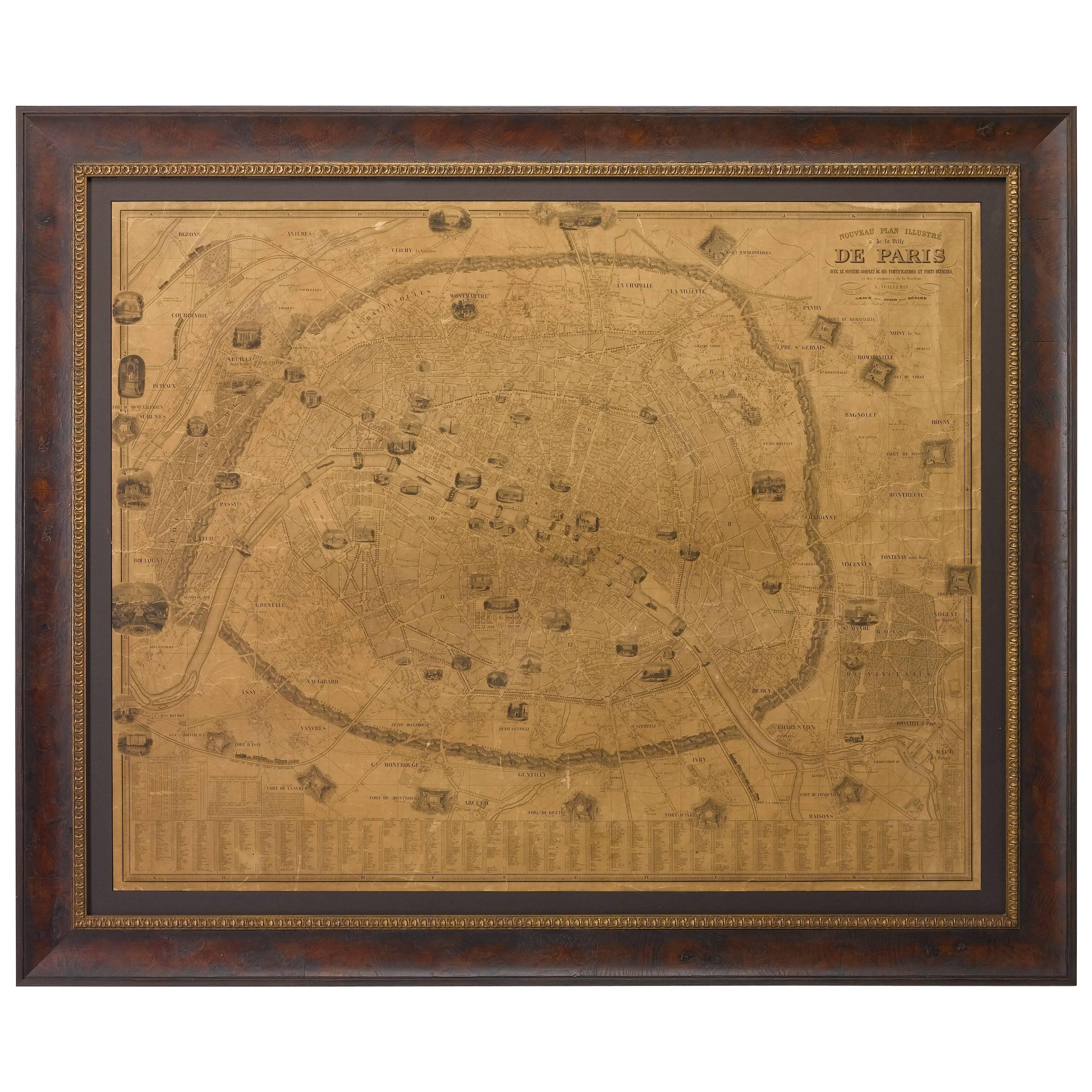
Plan of Paris, France, by A. Vuillemin, Antique Map, 1845
Located in Colorado Springs, CO
This large and detailed plan of Paris was published by Alexandre Vuillemin in 1845. The map conveys a wonderful amount of information and is decorated throughout with pictorial vigne...
Category
Antique 1840s American Maps
Materials
Paper

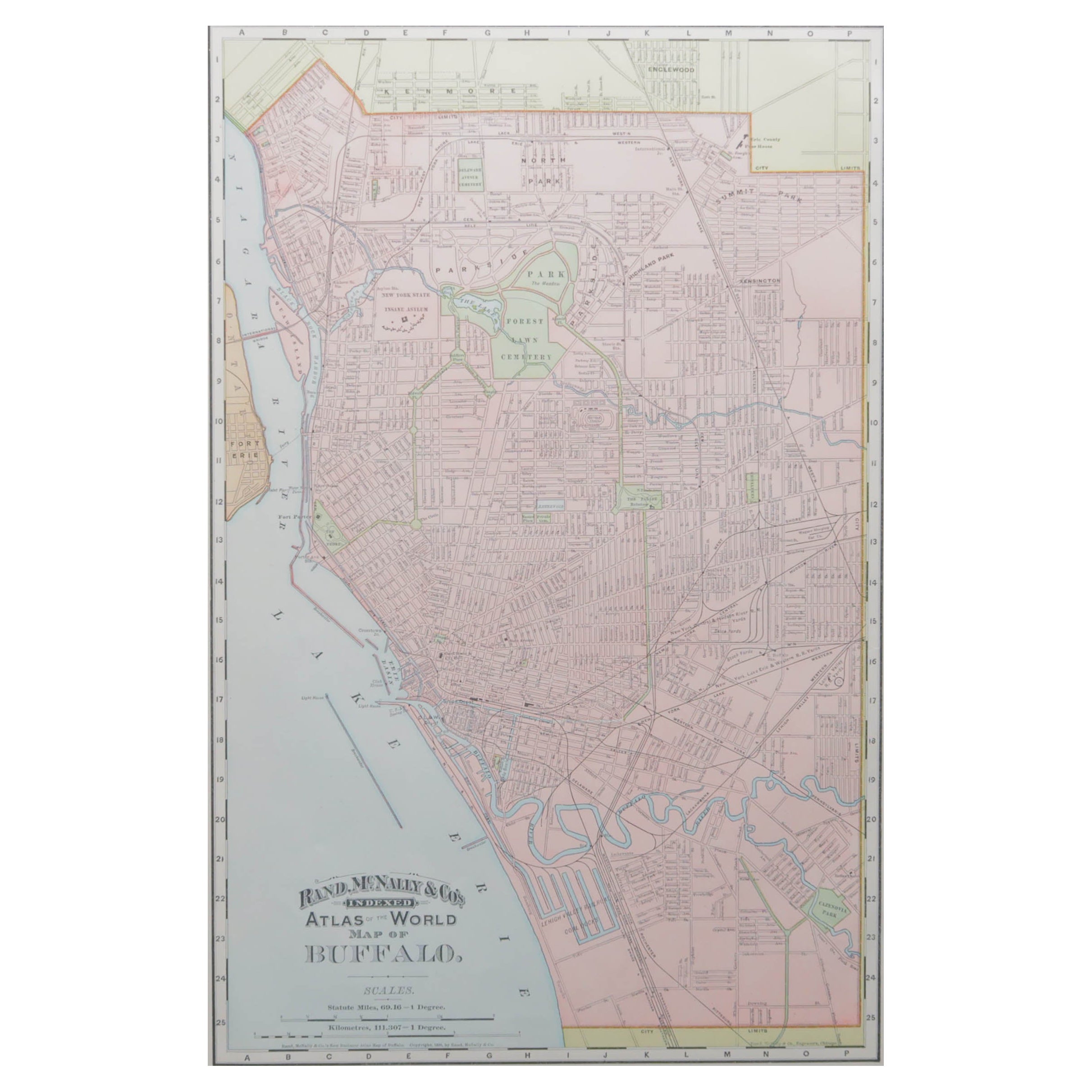
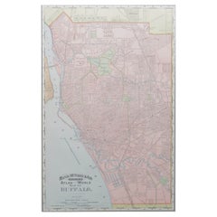
Original Antique City Plan of Buffalo, New York, USA, circa 1900
By Rand McNally & Co.
Located in St Annes, Lancashire
Fabulous colorful map of Buffalo
Original color
By Rand, McNally & Co.
Published, circa 1900
Unframed
Minor edge tears
Free shipping.
Category
Antique 1890s American Maps
Materials
Paper
Recently Viewed
View AllMore Ways To Browse
Antique Map Vietnam
Antique Maps Colorado
Cuba Map
Kolkata Antique Furniture
Magellan Map
Missouri Antique Map
Naples Map
Nevada Antique Map
Raleigh Antique Furniture
Cambodia Antique Map
Caucasus Map
Ecuador Antique Map
Gambia Antique Map
Guyana Antique Map
Mariners Chart
Papua New Guinea Antique Map
Tunisia Antique Map
Ukraine Antique Map