Items Similar to Ávila in a Historical Map of 1902: A Geographic and Administrative Overview

Want more images or videos?
Request additional images or videos from the seller
1 of 6
Ávila in a Historical Map of 1902: A Geographic and Administrative Overview
$277.38
$346.7320% Off
£205.35
£256.6820% Off
€232
€29020% Off
CA$383.83
CA$479.7920% Off
A$423.16
A$528.9520% Off
CHF 221.38
CHF 276.7320% Off
MX$5,191.41
MX$6,489.2720% Off
NOK 2,786.80
NOK 3,483.4920% Off
SEK 2,606.09
SEK 3,257.6220% Off
DKK 1,767.23
DKK 2,209.0420% Off
About the Item
The map is of the province of Ávila, one of the provinces of the autonomous community of Castile and León in Spain, and it is dated from 1902. The map illustrates several geographic and man-made features:
It shows the varying elevations within the province, with mountain ranges prominently displayed, likely including parts of the Sierra de Gredos.
The gold highlighted coat of arms of Ávila is prominently displayed in the upper left corner, featuring elements that are likely of historical and cultural significance to the province.
About the province of Ávila:
Ávila is known for its medieval city walls, which are among the best-preserved in Spain and have been designated a UNESCO World Heritage Site. The capital city, also named Ávila, is famous for being the birthplace of Saint Teresa of Jesus, an important Catholic saint, and for its Romanesque and Gothic churches.
The province itself is characterized by a rugged landscape, with the Sierra de Gredos providing a dramatic backdrop and a haven for outdoor activities like hiking and bird watching. The economy historically has been based on agriculture, with a focus on livestock, especially the renowned Ávila beef.
Ávila's cultural heritage includes not only its impressive architecture but also its culinary traditions, with local dishes such as "Judías del Barco" (beans from Barco) and "Chuletón de Ávila" (Ávila T-bone steak) being well-known in Spanish gastronomy.
- Dimensions:Height: 14.77 in (37.5 cm)Width: 20.08 in (51 cm)Depth: 0 in (0.02 mm)
- Materials and Techniques:
- Period:1900-1909
- Date of Manufacture:1902
- Condition:Good condition. Central vertical folding lines as issued. Aged paper with typically warm, yellowish-brown hue, especially around the edges. Part of the folding line is brownish, adding to its patina -check the images carefully.
- Seller Location:Langweer, NL
- Reference Number:Seller: BG-13642-51stDibs: LU3054338031452
About the Seller
5.0
Recognized Seller
These prestigious sellers are industry leaders and represent the highest echelon for item quality and design.
Platinum Seller
Premium sellers with a 4.7+ rating and 24-hour response times
Established in 2009
1stDibs seller since 2017
2,609 sales on 1stDibs
Typical response time: <1 hour
- ShippingRetrieving quote...Shipping from: Langweer, Netherlands
- Return Policy
Authenticity Guarantee
In the unlikely event there’s an issue with an item’s authenticity, contact us within 1 year for a full refund. DetailsMoney-Back Guarantee
If your item is not as described, is damaged in transit, or does not arrive, contact us within 7 days for a full refund. Details24-Hour Cancellation
You have a 24-hour grace period in which to reconsider your purchase, with no questions asked.Vetted Professional Sellers
Our world-class sellers must adhere to strict standards for service and quality, maintaining the integrity of our listings.Price-Match Guarantee
If you find that a seller listed the same item for a lower price elsewhere, we’ll match it.Trusted Global Delivery
Our best-in-class carrier network provides specialized shipping options worldwide, including custom delivery.More From This Seller
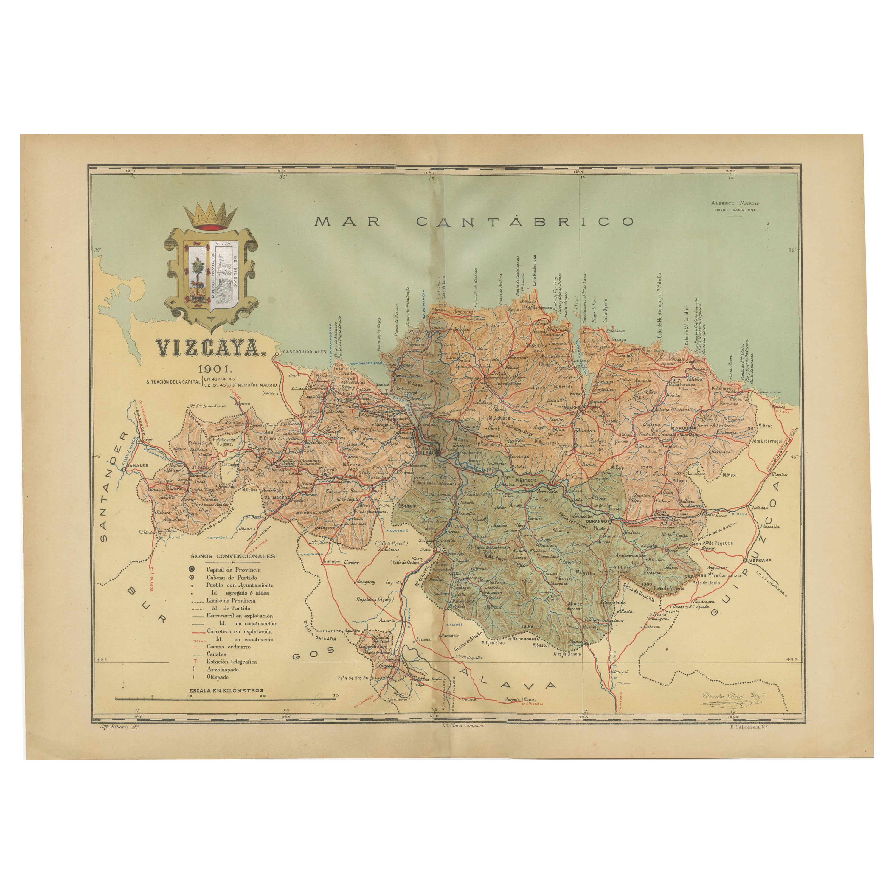
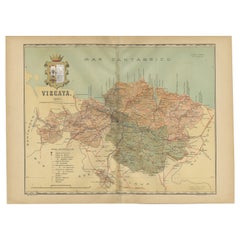
View AllCartographic Heritage: The 1901 Map of the Vizcaya Province in Spain
Located in Langweer, NL
This is a historical map of the province of Vizcaya (Biscay) in Spain, dated 1901. The title on the map is "VIZCAYA. 1901." It shows the topographical details of the region with cont...
Category
Antique Early 1900s Maps
Materials
Paper
$306 Sale Price
20% Off
Free Shipping
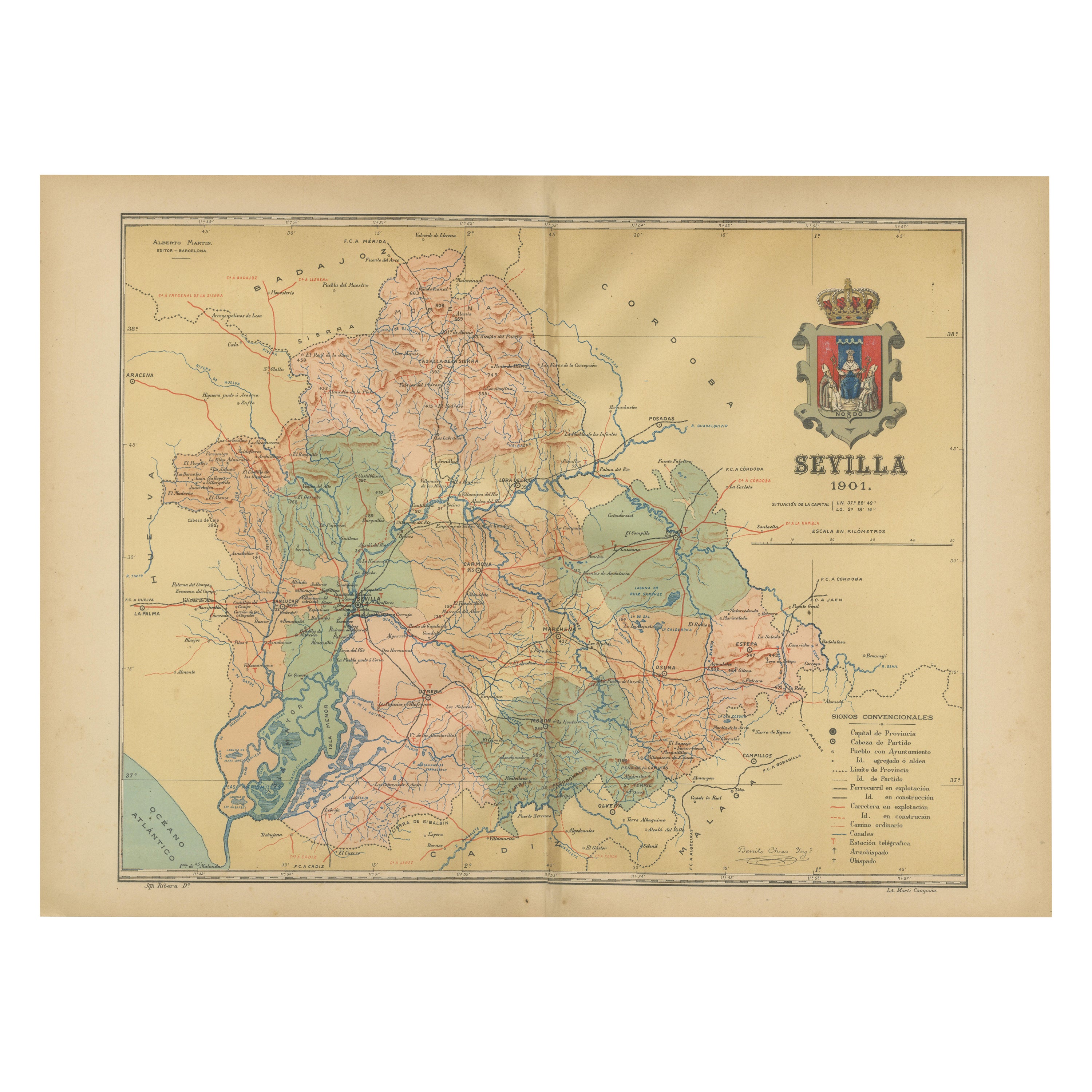
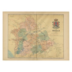
Map of Sevilla Province, 1901: A Depiction of The Spanish Cultural Heartland
Located in Langweer, NL
The print for sale here depicts a historical map of the province of Sevilla (Seville) from the year 1901. Sevilla is located in the southern part of Spain and is part of the autonomo...
Category
Antique Early 1900s Maps
Materials
Paper
$267 Sale Price
30% Off
Free Shipping
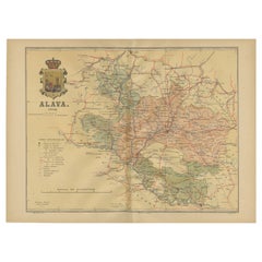
Álava in Northern Spain: The Geography of Basque Heritage and Terrain, 1902
Located in Langweer, NL
This original antique map is a historical depiction of the province of Álava (in Basque: Araba), which is one of the provinces of the Basque Country in northern Spain, as indicated b...
Category
Antique Early 1900s Maps
Materials
Paper
$277 Sale Price
20% Off
Free Shipping
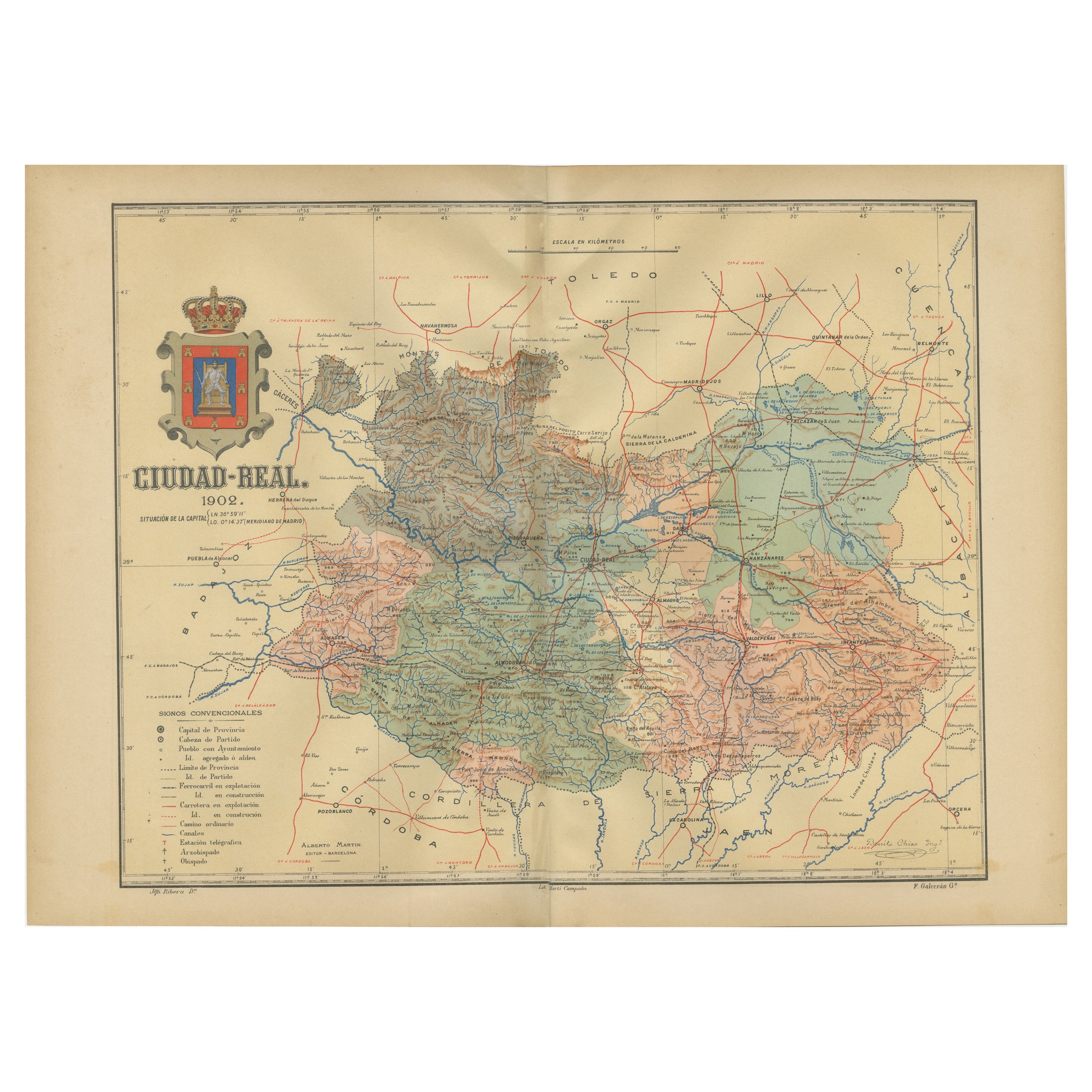
Ciudad Real 1902: A Detailed Cartographic Survey of La Mancha in Spain
Located in Langweer, NL
This original antitque map presents the province of Ciudad Real, located in the autonomous community of Castilla-La Mancha in central Spain, as of 1902. It includes several notable f...
Category
Antique Early 1900s Maps
Materials
Paper

$325 Sale Price
20% Off
Free Shipping
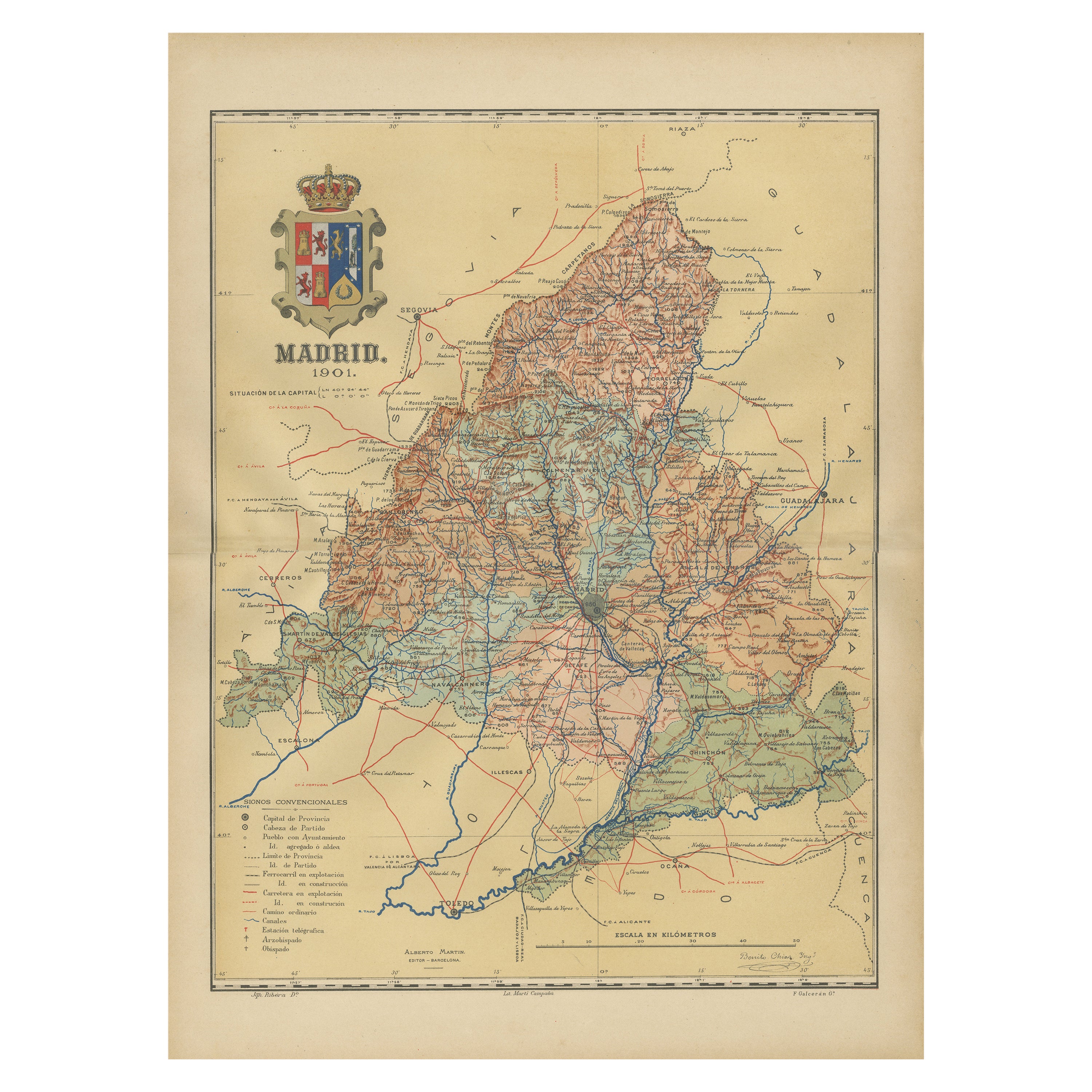
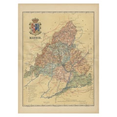
Madrid 1901: A Historical Map of Spain's Capital Province
Located in Langweer, NL
The map is of the province of Madrid, the capital region of Spain, as it appeared in 1901. Here are the key features it displays:
The map shows the central part of Spain, with the Guadarrama mountain range prominently visible, marking the natural border to the north of Madrid.
Blue lines likely indicate rivers, including the Manzanares River, which flows through Madrid, and the Jarama River, a tributary to the Tagus.
Red lines depict the roads and railways, outlining the infrastructure that connects Madrid's various towns and cities within the province and beyond.
Symbols and labels mark the locations of cities, towns, and villages, with Madrid itself likely being the focal point. Dotted lines may represent the administrative divisions within the province. The map includes a legend (Signos Convencionales) that explains the symbols used for provincial capitals, roads, railways, and other geographic features.
The coat of arms of Madrid, featuring a bear and a strawberry tree (madroño), is prominently featured, symbolizing the city's and the province's historical coat of arms.
About the province of Madrid:
Madrid is not only the capital of Spain but also the heart of the Iberian Peninsula, both geographically and politically. The city is renowned for its rich repositories of European art, including the Prado Museum's works by Goya, Velázquez, and other Spanish masters. The province of Madrid is characterized by a blend of historical and modern elements, with a rich cultural life that includes theater, opera, and flamenco, as well as gastronomy that features a mix of traditional Spanish dishes and international cuisine...
Category
Antique Early 1900s Maps
Materials
Paper
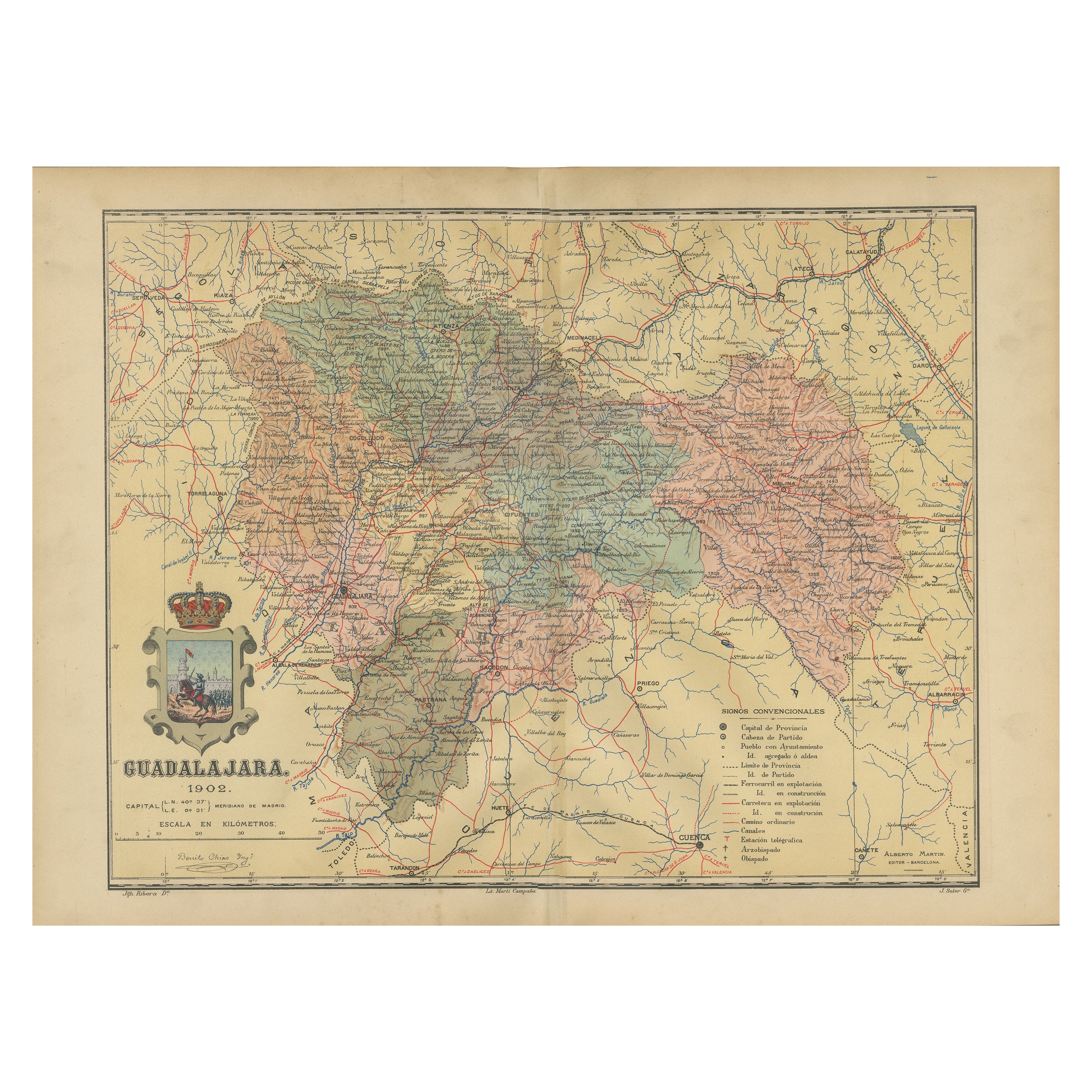
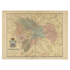
Guadalajara 1902: A Cartographic Image of Castilla-La Mancha's Northern Province
Located in Langweer, NL
The map illustrates the province of Guadalajara, part of the autonomous community of Castilla-La Mancha in Spain, as of 1902. The map includes various geographic and infrastructural ...
Category
Antique Early 1900s Maps
Materials
Paper
$277 Sale Price
20% Off
Free Shipping
You May Also Like
Large Original Vintage Map of Spain, circa 1920
Located in St Annes, Lancashire
Great map of Spain
Original color.
Good condition
Published by Alexander Gross
Unframed.
Category
Vintage 1920s English Maps
Materials
Paper

Original Antique Map of Spain and Portugal, circa 1790
Located in St Annes, Lancashire
Super map of Spain and Portugal
Copper plate engraving by A. Bell
Published, circa 1790.
Unframed.
Category
Antique 1790s English Other Maps
Materials
Paper

Large Original Vintage Map of Mexico, circa 1920
Located in St Annes, Lancashire
Great map of Mexico
Original color.
Good condition
Published by Alexander Gross
Unframed.
Category
Vintage 1920s English Edwardian Maps
Materials
Paper
South America, Eastern Part. Century Atlas antique vintage map
Located in Melbourne, Victoria
'The Century Atlas. South America. Eastern Part'
Original antique map, 1903.
Inset map 'Rio de Janeiro and Vicinity'.
Central fold as issued. Map name and number printed on the rev...
Category
Early 20th Century Victorian More Prints
Materials
Lithograph

Original Antique Map of the American State of Arizona & New Mexico, 1903
Located in St Annes, Lancashire
Antique map of Arizona and New Mexico
Published By A & C Black. 1903
Original colour
Good condition
Unframed.
Free shipping
Category
Antique Early 1900s English Maps
Materials
Paper

Original 1891 Walker Map
Located in Norwell, MA
Original 1891 map of Massachusetts by Walker. Towns include Cambridge, Boston, Dedham, Ashland, Brookline, Newton etc... burl wood frame. Measures...
Category
Antique 19th Century Maps

More Ways To Browse
Gothic Church
Earth Toned Rug
United Chair Company
Mid Century Modern Danish Teak Dining Tables
Mid Century Wrought Iron Chairs
Shirvan Rugs
Antique Carved Wood Chair
Brown Sheepskin Chair
Gold Modern Coffee Table
18th Century Wood Side Tables
1960s Glass Top Coffee Table
Black Glass Coffee Tables
Mid Century Modern Yellow Chair
18th Century Engravings
Italian Console With Mirror
Midcentury Japanese Ceramics
Black Marble Table Vintage
Blue Green Wool And Silk Rug