Items Similar to Bird's Eye View of Dabhol as Seen from the Sea, North of Goa, India, 1727
Want more images or videos?
Request additional images or videos from the seller
1 of 6
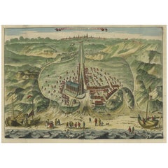
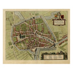
Bird's Eye View of Dabhol as Seen from the Sea, North of Goa, India, 1727
About the Item
Antique print titled 'De Bay ende Stadt Dabul'.
Bird's eye view of Dabhol as seen from the sea. The city is situated on the Vashishti river, north of Goa in India, on the Malabar Coast. The view shows merchant and fishing ships, as well as a small caravan on the beach. Details defensive batteries on the coast.This plate originates from the very scarse: 'La Galerie Agreable du Monde (...). Tome premier d' Afrique.', published by P. van der Aa, Leyden, c. 1725. This famous work was published in 66 parts and is the biggest print / map book ever published. Van der Aa incorporated plates by other publishers such as Blaeu, Visscher, de Wit, meurs, Halma, Mortier, Allard in this work and often added broad decorative borders. Probably the costliest and complete universal geographic work ever produced. It is said that only 100 copies were printed. Ref: Koeman Aa9; Phillips 2780 note. Rare. Extremely rare.
Artists and Engravers: Pieter van der Aa Pieter van der Aa (Leiden 1659-1733) was a Dutch publisher best known for preparing maps and atlases. The Galerie Agreable contains plates and maps by the best Dutch engravers: Luiken, Goeree, Mulder, Stoopendaal, Aldert Meijer, Romeyn de Hooghe, ao.
- Dimensions:Height: 11.82 in (30 cm)Width: 16.15 in (41 cm)Depth: 0 in (0.02 mm)
- Materials and Techniques:
- Period:1720-1729
- Date of Manufacture:1727
- Condition:Condition: Very good, given age. Margins cropped to the platemark. Attached to carrier sheet. Carrier margins faintly soiled and glue remains of tape in the top edge. General age-related toning and/or occasional minor defects from handling.
- Seller Location:Langweer, NL
- Reference Number:
About the Seller
5.0
Platinum Seller
These expertly vetted sellers are 1stDibs' most experienced sellers and are rated highest by our customers.
Established in 2009
1stDibs seller since 2017
1,929 sales on 1stDibs
Typical response time: <1 hour
- ShippingRetrieving quote...Ships From: Langweer, Netherlands
- Return PolicyA return for this item may be initiated within 14 days of delivery.
More From This SellerView All
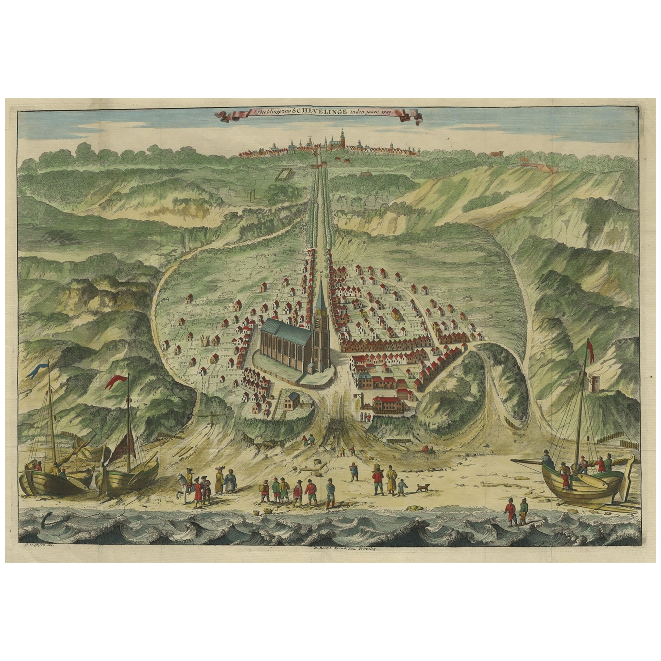
- Antique Bird's Eye View of Scheveningen Near The Hague, the Netherlands, 1730Located in Langweer, NLAntique print titled 'Afbeeldinge van Schevelinge in den Jaare 1729'. Bird's eye view of Scheveningen near The Hague / Den Haag, the Netherlands. This print originates from 'Besc...Category
Antique 1730s Maps
MaterialsPaper
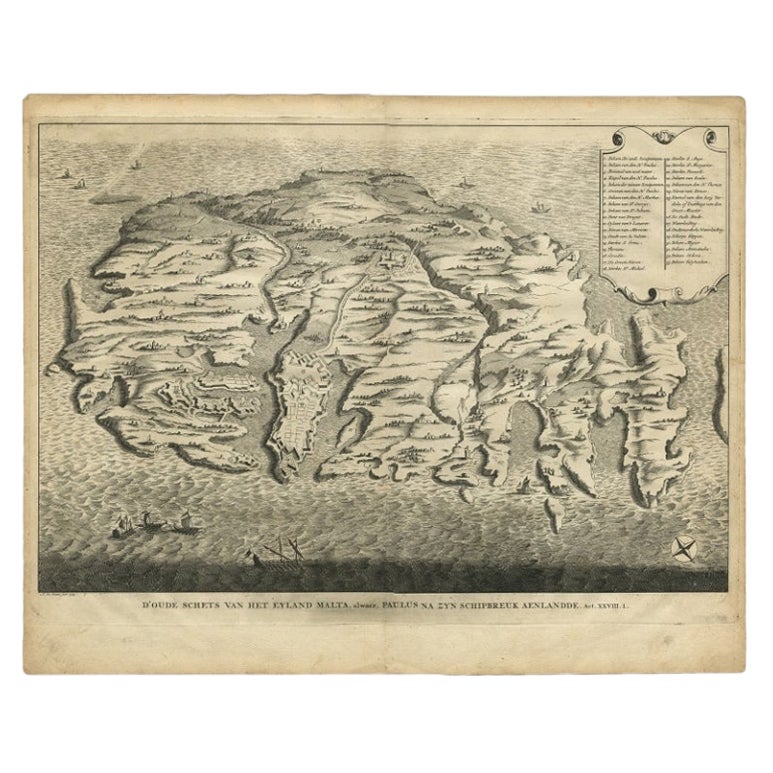
- Rare Antique Bird's-eye View Map of The Island of Malta, 1729Located in Langweer, NLAntique print titled 'D'oude Schets van het Eyland Malta, alwaer, Paulus na zyn Schipbreuk Aenlandde.' This is an uncommon bird's-eye view map of the island of Malta. The map pre...Category
Antique 18th Century Maps
MaterialsPaper
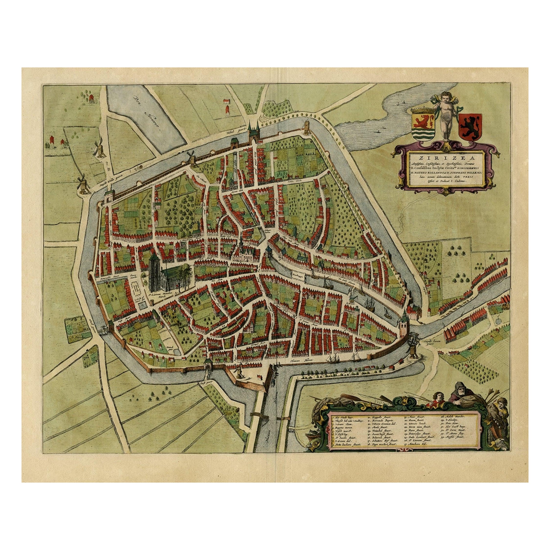
- Antique Bird's-eye View Plan of Zierikzee in Zeeland, The Netherlands, 1649Located in Langweer, NLAntique print, titled: 'Zirizea.' - A bird's-eye view plan of Zierikzee in The Netherlands, with key to locations and coats of arms. After Matheo Rollando and Stephano Bellemo. Latin tekst on verso. From the city Atlas: 'Toneel der Steeden' published by Joan Blaeu...Category
Antique 1640s Maps
MaterialsPaper
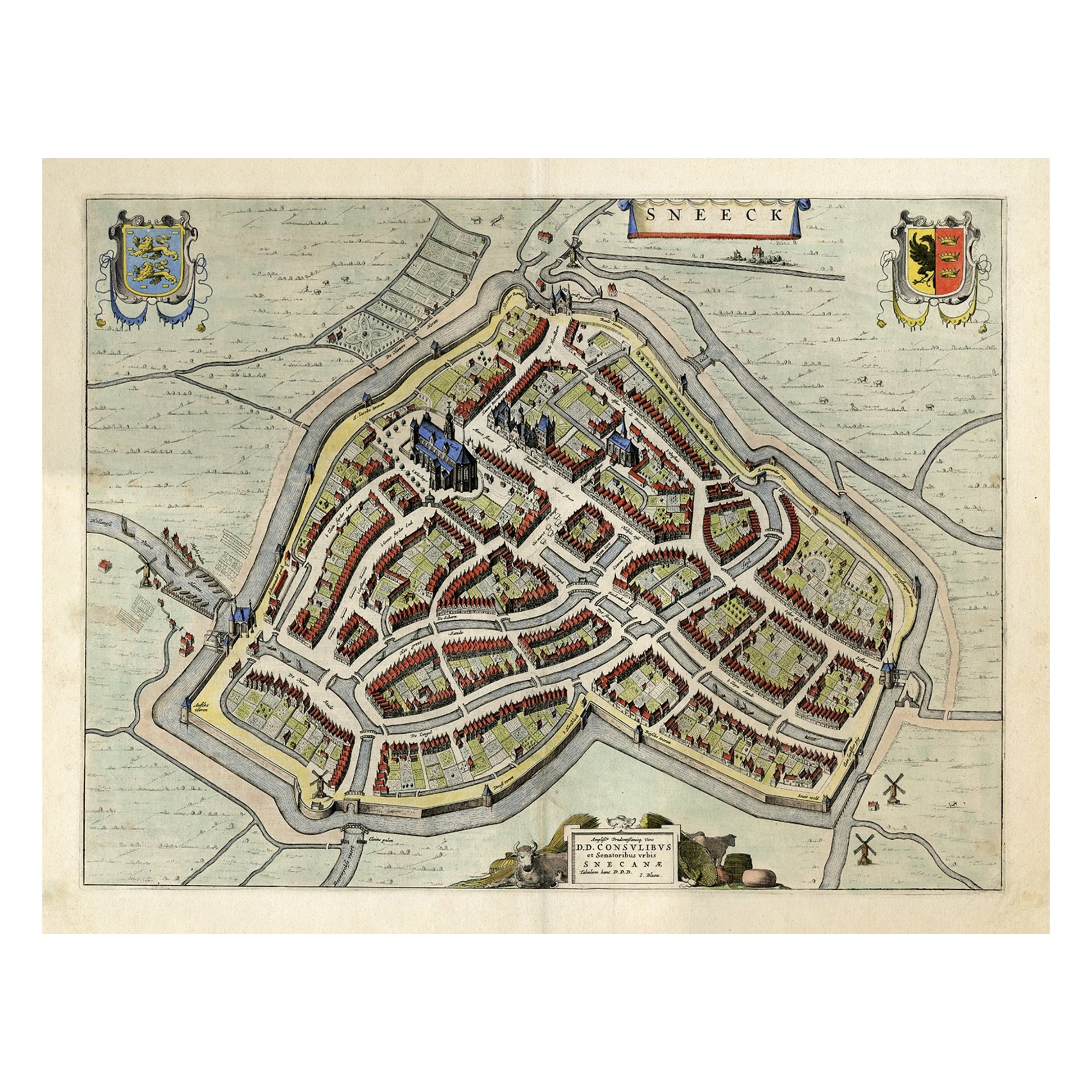
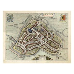
- Original Old Bird's-eye View plan of Sneek, Friesland, The Netherlands, 1649Located in Langweer, NLAntique map titled: 'Sneeck.' Bird's-eye view plan of Sneek, Friesland, The Netherlands. Text in Latin on verso. This plan originates from the famous city Atlas: 'Toneel der Steeden'...Category
Antique 1640s Maps
MaterialsPaper
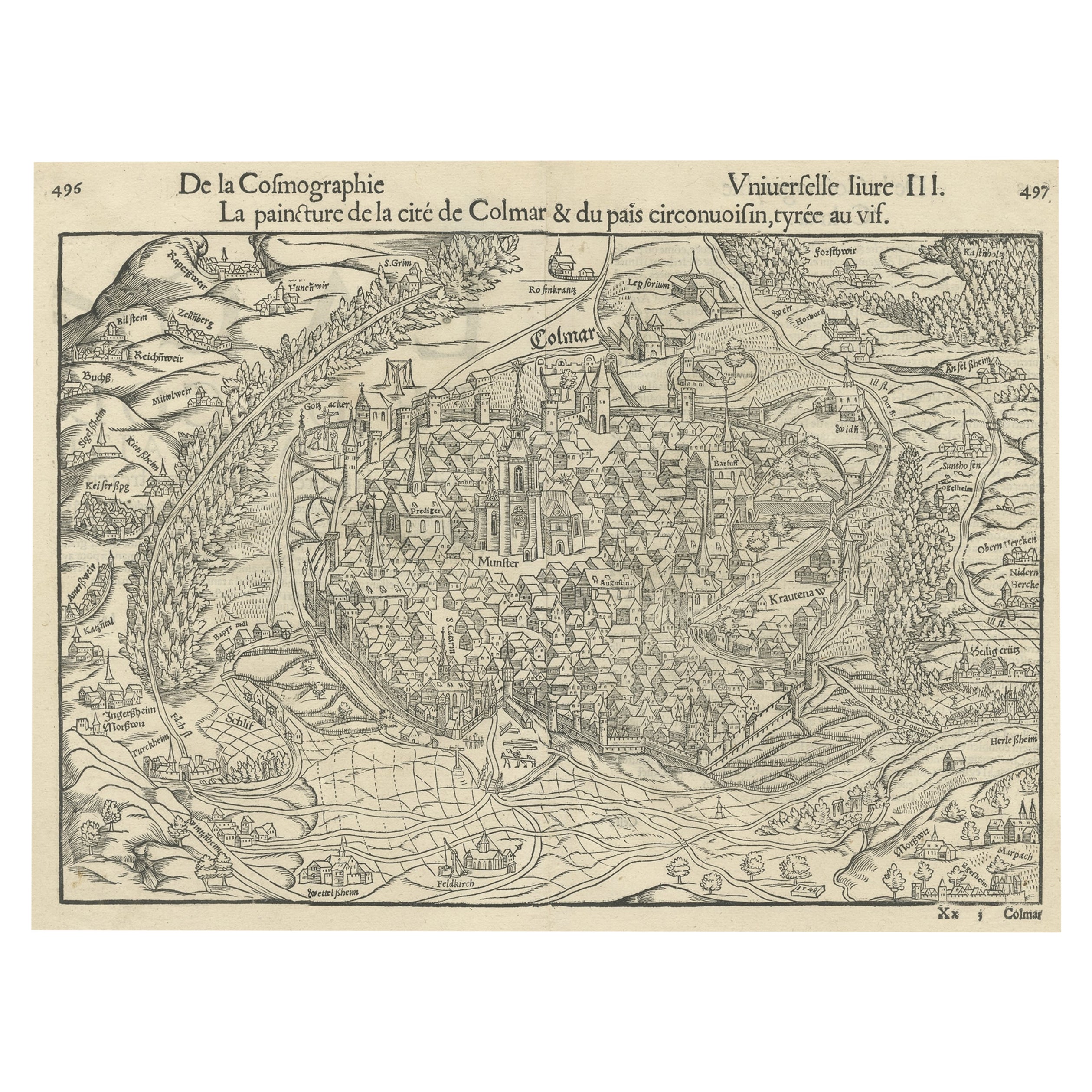
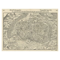
- Original Antique Bird's-Eye View of Colmar, Alsace, France, 1552Located in Langweer, NLAntique map titled 'La Paincture de la cité de Colmar & du pais circonuoisin'. Original antique bird's-eye view of Colmar, Alsace, France. This map originates from 'La Cosmograph...Category
Antique 16th Century Maps
MaterialsPaper
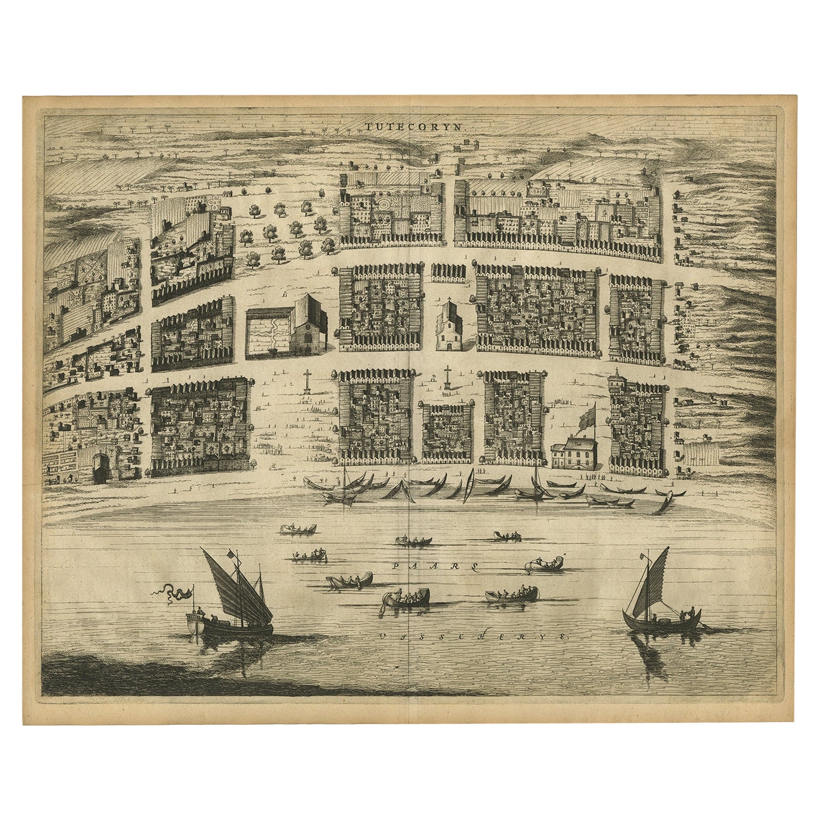
- Antique Bird's-Eye Plan of Tutecoryn (Tuticorin or Thoothukudi), India, 1672Located in Langweer, NLAntique map, titled: 'Tutecoryn.' Bird's-eye plan of map of Tutecoryn (Tuticorin or Thoothukudi), India. This map originates from 'Naauwkeurige Beschryvinge van Malabar en Choroman...Category
Antique 1670s Maps
MaterialsPaper
You May Also Like
- New Map of North America from the Latest Discoveries, 1763Located in Philadelphia, PAA fine antique 18th century map of the North American seaboard. Entitled "A New Map of North America from the Latest Discoveries 1763". By the Cartographer/Engraver - John Spil...Category
Antique Mid-18th Century English Georgian Maps
MaterialsPaper
- Vintage "View of the Center of Paris Taken from the Air" Lithograph MapLocated in San Diego, CAA very stylish "View of the Center of Paris Taken from the Air" lithograph map published by the Paris Ministry of Tourism, circa early 1950s. The piece measures 27" x 43" and shows...Category
20th Century French Mid-Century Modern Prints
MaterialsPaper
- Original Antique Map of India. C.1780Located in St Annes, LancashireGreat map of India Copper-plate engraving Published C.1780 Three small worm holes to right side of map and one bottom left corner Unframed.Category
Antique Early 1800s English Georgian Maps
MaterialsPaper

- Large Antique 1859 Map of North AmericaLocated in Sag Harbor, NYThis Map was made by Augustus Mitchell in 1859 It is in amazing condition for being 163 years old. This price is for the rolled up easy to ship version of this piece. I will be Frami...Category
Antique Mid-19th Century American Maps
MaterialsCanvas, Paper

- Alpine Ski Photograph, 'Panoramic View', Taken from Original 1930s PhotographLocated in Oxfordshire, GBVintage, antique Alpine Ski photograph. 'Panoramic View', a new mounted black and white photographic image after an original 1930s skiing photograph. Black and white alpine photos are the perfect addition to any home or ski lodge, so please do check out our other ski photos...Category
Vintage 1930s English Sporting Art Sports Equipment and Memorabilia
MaterialsPaper
- N.E. View of the United States Capitol, Washington, DC Antique Proof Print 1858Located in Colorado Springs, COThis engraved print shows a view of the United States Capitol Building, in Washington, D.C. The print depicts the neoclassical building from the northeast orientation, with a bustling street scene in front. The steel engraving is a proof printing, drawn and engraved by Henry Sartain and published in 1858. Plans began in May 1854 to build a new cast-iron dome for the United States Capitol. The then-architect of the Capitol Thomas Walter and his team were sold on the aesthetics of a new dome, as well as the utility of a fire-proof one. A year later, on March 3, 1855, President Franklin Pierce...Category
Antique 1850s American Prints
MaterialsPaper


Recently Viewed
View AllMore Ways To Browse
Extremely Rare Collectible
Premier Used Office Furniture
Fishing Collectibles
Antique Ship Parts
Rare Fishing
Premier Antiques
Fishing Birds
Used Furniture North Bay
Antique Fishing Prints
Antique Fishing Collectables
Mortier Antique
Antique Print Beach
Antique Caravans
Goa Furniture
Map Monde Antique
Afrique Antique
Birds Eye View Map
Antique Furniture Goa