Items Similar to Hand-Colored 17th-Century Map of Orléanais in France by Frederik De Wit c. 1688


Want more images or videos?
Request additional images or videos from the seller
1 of 6
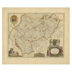
Hand-Colored 17th-Century Map of Orléanais in France by Frederik De Wit c. 1688
$417.99
£309.09
€350
CA$574.15
A$638.42
CHF 334.22
MX$7,798.38
NOK 4,199.84
SEK 3,950.79
DKK 2,664.98
About the Item
Title: Hand-Colored 17th-Century Map of Orléanais by Frederik De Wit c. 1688
Description: This beautifully crafted map, "Gouvernement General du Pays Orléanois," illustrates the Orléanais region of France as it was in the late 17th century. Created by Frederik De Wit and published circa 1688, this map is a testament to the golden age of Dutch cartography. It features intricate engraving and vibrant original hand-coloring, detailing towns, rivers, forests, and regional boundaries. The map also includes an impressive cartouche adorned with coats of arms and allegorical figures, showcasing the cultural and political importance of the Orléanais region.
De Wit’s maps were often included in his renowned composite atlases, combining beauty and accuracy to cater to a scholarly and aristocratic audience. His skillful representation of geography and artistic flourishes makes this map not only a historical artifact but also a work of art. The Orléanais, with its historical significance and connection to French royalty, is vividly brought to life through De Wit’s craftsmanship.
Frederik De Wit remains one of the most celebrated cartographers of his time, with his works highly sought after by collectors. This map is an exceptional example of his ability to merge geographic precision with artistic detail.
Condition Report: The map is in fair to good condition, with vibrant original hand-coloring. There are minor age-related imperfections such as light foxing and faint toning. The oxidation of the green color has weakened the paper at some places and archival tape is placed at verso to reinforce the paper. Please review the image for additional details or ask for more images.
Framing and Matting Tips: Enhance the map’s appeal with a classic gold or dark wood frame that complements its original hand-coloring and decorative cartouche. Use acid-free matting in a neutral tone to protect the paper and highlight its intricate details. For preservation, UV-protective glass is recommended to maintain the colors’ vibrancy. This map is a perfect addition to a study, gallery, or office, offering both historical depth and artistic charm.
- Dimensions:Height: 20.83 in (52.9 cm)Width: 24.41 in (62 cm)Depth: 0.01 in (0.2 mm)
- Materials and Techniques:Paper,Engraved
- Period:1680-1689
- Date of Manufacture:circa 1688
- Condition:Repaired: Green color oxidation has weakened some areas, reinforced with archival tape on verso. Condition Report: Fair to good condition with vibrant hand-coloring. Minor foxing and faint toning. Green color oxidation has weakened some areas, reinforced with archival tape on verso. See images for details or request more.
- Seller Location:Langweer, NL
- Reference Number:Seller: BG-14046-81stDibs: LU3054343439162
About the Seller
5.0
Recognized Seller
These prestigious sellers are industry leaders and represent the highest echelon for item quality and design.
Platinum Seller
Premium sellers with a 4.7+ rating and 24-hour response times
Established in 2009
1stDibs seller since 2017
2,604 sales on 1stDibs
Typical response time: <1 hour
- ShippingRetrieving quote...Shipping from: Langweer, Netherlands
- Return Policy
Authenticity Guarantee
In the unlikely event there’s an issue with an item’s authenticity, contact us within 1 year for a full refund. DetailsMoney-Back Guarantee
If your item is not as described, is damaged in transit, or does not arrive, contact us within 7 days for a full refund. Details24-Hour Cancellation
You have a 24-hour grace period in which to reconsider your purchase, with no questions asked.Vetted Professional Sellers
Our world-class sellers must adhere to strict standards for service and quality, maintaining the integrity of our listings.Price-Match Guarantee
If you find that a seller listed the same item for a lower price elsewhere, we’ll match it.Trusted Global Delivery
Our best-in-class carrier network provides specialized shipping options worldwide, including custom delivery.More From This Seller
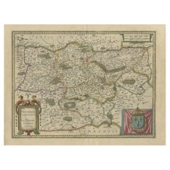
View AllRare Hand-Colored Map of Lorraine and Barrois, France by Frederik De Wit c. 1688
Located in Langweer, NL
Title: Rare Hand-Colored Map of Lorraine and Barrois by Frederik De Wit c. 1688
Description: This remarkable 17th-century map, titled "Generalis Lotharingiae Ducatus," offers a deta...
Category
Antique 1680s Maps
Materials
Paper

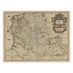
Île-de-France Map, including Paris - Hand-Colored Engraving by F. De Wit c. 1688
Located in Langweer, NL
Title: Hand-Colored 17th-Century Map of Île-de-France by Frederik De Wit c. 1688
Description: This striking map, "Le Gouvernement de l’Isle de France," showcases the Île-de-France r...
Category
Antique 1680s Maps
Materials
Paper
Antique Map of the Artois Region 'France' by F. de Wit, circa 1680
Located in Langweer, NL
Antique map titled 'Tabula Comitatus Artesiae emendata'. Large map of the Artois region, France. Published by F. de Wit, circa 1680.
Category
Antique Late 17th Century Maps
Materials
Paper

$515 Sale Price
25% Off
Old Original Handcoloured Map of the Former Province of Perche, France, ca.1640
Located in Langweer, NL
Antique map titled 'Perchensis Comitatus - La Perche compte'.
Old map of the former province of Perche, France. Until the French Revolution, Perche was bounded by four ancient te...
Category
Antique 1640s Maps
Materials
Paper
$687 Sale Price
20% Off
Original Hand-Colored Antique Map of Artois or Artesia, France, ca.1650
Located in Langweer, NL
Antique map titled 'Artesia Comitatus Artois'.
Map of Artois or Artesia, France. Artois is former province located in the northwestern part of France, boarding Belgium (Flanders)...
Category
Antique 1650s Maps
Materials
Paper
$324 Sale Price
20% Off
Rare Hand-Colored Map of Lyonnais Region in France by Frederik De Wit c. 1688
Located in Langweer, NL
Title: Rare Hand-Colored Map of Lyonnais Region by Frederik De Wit c. 1688
Description: This beautifully detailed map, "Gouvernement General du Lyonnois," showcases the Lyonnais reg...
Category
Antique 1680s Maps
Materials
Paper

You May Also Like
The Loire Valley of France: A 17th C. Hand-colored Map by Sanson and Jaillot
By Nicholas Sanson d'Abbeville
Located in Alamo, CA
This large 17th century copper plate hand-colored engraved map entitled "Gouvernement D'Orleans et la Generalite divisee en ses Elections Par...
Category
1690s Landscape Prints
Materials
Engraving

1656 Jansson Map Metz Region of France Entitled "Territorium Metense" Ric0014
Located in Norton, MA
1656 Jansson map Metz Region of France entitled "Territorium Metense."
Ric0014
" Authentic" - Map of the historical region surrounding Metz, in Lorraine, France.
Oriented with ...
Category
Antique 17th Century Dutch Maps
Materials
Paper

1640 Joan Bleau Map Entitled"Diocecese de rheims et le pais de rethel, " Eic.a011
Located in Norton, MA
1640 Joan Bleau map entitled
"Diocecese de rheims et le pais de rethel,"
Ric.a011
OAN BLAEU
Diocecese de Rheims, et le pais de Rethel.
Handcolored engraving, c.1640.
...
Category
Antique 17th Century Dutch Maps
Materials
Paper

The Normandy Region of France: A 17th C. Hand-colored Map by Sanson and Jaillot
By Nicholas Sanson d'Abbeville
Located in Alamo, CA
This large hand-colored map entitled "Le Duché et Gouvernement de Normandie divisée en Haute et Basse Normandie en divers Pays; et par evêchez, avec le Gouvernement General du Havre ...
Category
1690s Landscape Prints
Materials
Engraving

1771 Bonne Map of Poitou, Touraine and Anjou, France, Ric.a015
Located in Norton, MA
1771 Bonne Map of Poitou,
Touraine and Anjou, France
Ric.a015
1771 Bonne map of Potiou, Touraine and Anjou entitled "Carte des Gouvernements D'Anjou et du Saumurois, de la Touraine, du Poitou,du Pays d'aunis, Saintonge?Angoumois,"
Carte des gouvernements d'Anjou et du Saumurois, de la Touraine, du Poitou, du Pays d'Aunis, Saintonge-Angoumois. Projettee et assujettie au ciel par M. Bonne, Hyd. du Roi. A Paris, Chez Lattre, rue St. Jacques a la Ville de Bord(ea)ux. Avec priv. du Roi. 1771. Arrivet inv. & sculp., Atlas moderne ou collection de cartes sur toutes...
Category
Antique 17th Century Unknown Maps
Materials
Paper

1635 Willem Blaeu Map of Northern France"Comitatvs Bellovacvm" Ric.a08
Located in Norton, MA
1635 Willem Blaeu map of northern France, entitled.
"Comitatvs Bellovacvm Vernacule Beavvais,"
Colored
Ric.a008
“COMITATVS BELLOVACVM…” Amsterdam: W...
Category
Antique 17th Century Unknown Maps
Materials
Paper

More Ways To Browse
French Matting
17th Century Dutch Wood Frames
Carlo Scarpa 1934 Chairs
Christofle Marly
1900 Antique Chairs
Glass Table Italian Round
Alvar Aalto Poster
Geometric Metal Table
Post Modern High Chairs
Vintage Vine Rug
Cancel An Order
Antique Framing Square
Silver Metal Chair
Swedish Kilim
Vintage Scandanavian Chairs
Vintage Tropical Furniture
19th Century Red Glass
Antique French Console Table Tables