Items Similar to Large Scale Map of the London Metropolis

Want more images or videos?
Request additional images or videos from the seller
1 of 9
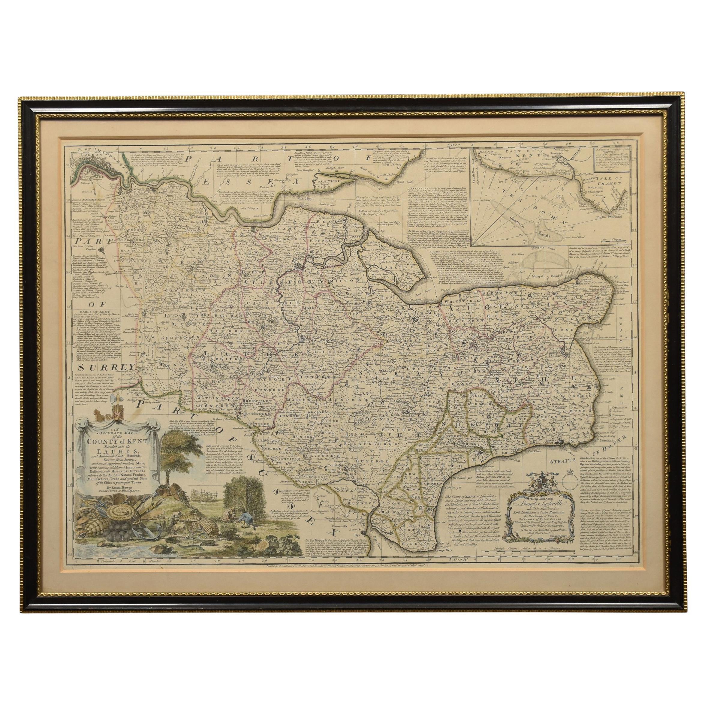
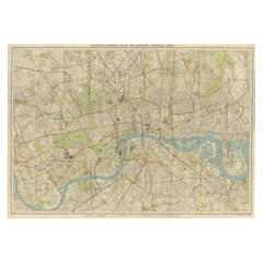
Large Scale Map of the London Metropolis
$5,800
£4,405.57
€5,076.71
CA$8,167.84
A$9,055.25
CHF 4,758.89
MX$110,821.46
NOK 59,433.69
SEK 55,784.47
DKK 37,894.52
About the Item
The product is a large scale map of the London Metropolis, specifically focusing on the city in intricate detail. It would be a valuable collectible for those interested in maps and atlases, as well as for individuals who collect items related to transportation or urban regions. Circa 1970
56h x 83w
- Dimensions:Height: 56 in (142.24 cm)Width: 83 in (210.82 cm)Depth: 2 in (5.08 cm)
- Materials and Techniques:
- Place of Origin:
- Period:
- Date of Manufacture:1970
- Condition:
- Seller Location:Dallas, TX
- Reference Number:Seller: SKU000100891stDibs: LU1077043689822
About the Seller
5.0
Platinum Seller
Premium sellers with a 4.7+ rating and 24-hour response times
Established in 1997
1stDibs seller since 2014
845 sales on 1stDibs
Typical response time: 2 hours
- ShippingRetrieving quote...Shipping from: Dallas, TX
- Return Policy
Authenticity Guarantee
In the unlikely event there’s an issue with an item’s authenticity, contact us within 1 year for a full refund. DetailsMoney-Back Guarantee
If your item is not as described, is damaged in transit, or does not arrive, contact us within 7 days for a full refund. Details24-Hour Cancellation
You have a 24-hour grace period in which to reconsider your purchase, with no questions asked.Vetted Professional Sellers
Our world-class sellers must adhere to strict standards for service and quality, maintaining the integrity of our listings.Price-Match Guarantee
If you find that a seller listed the same item for a lower price elsewhere, we’ll match it.Trusted Global Delivery
Our best-in-class carrier network provides specialized shipping options worldwide, including custom delivery.More From This Seller
View AllAntique Map of France
Located in Dallas, TX
Nice antique map of France in wood frame. This would make a great gift for a collector. A wonderful accessory!
Category
Early 20th Century Decorative Art
Materials
Glass, Wood, Paper

$1,760
Antique Oil on Canvas Painting of a Venetian Harbor
Located in Dallas, TX
Very fine antique painting of a busy Venetian harbor. Featuring beautiful architecture, boats, and figures. A wonderful piece of art! Circa 1920.
58w x 42h
Category
Early 20th Century Paintings and Screens
Materials
Canvas

$7,840 Sale Price
20% Off
19th Century French Empire Style Salesman Sample
Located in Dallas, TX
Charming French late 19th century Empire style salesman sample. Makes a fine accessory.
Category
Antique 19th Century French Empire Decorative Boxes
Materials
Wood
French Mid-Century Sideboard
Located in Dallas, TX
Outstanding French Mid-century mahogany and ebony sideboard with brass trim. Circa 1940. A timeless and classic touch for a fine interior.
Category
Vintage 1940s Sideboards
Materials
Mahogany
$14,500
French Magazine Holder
Located in Dallas, TX
Vintage French Jansen manner brass and leather magazine holder. Circa 1940. A fine addition to any home!
Category
Vintage 1940s Magazine Racks and Stands
Materials
Brass
$1,600
18th Century Pair of English Engravings
Located in Dallas, TX
Superb pair of 18th century English engravings.
Category
Antique 18th Century English Decorative Art

$2,035 / set
You May Also Like
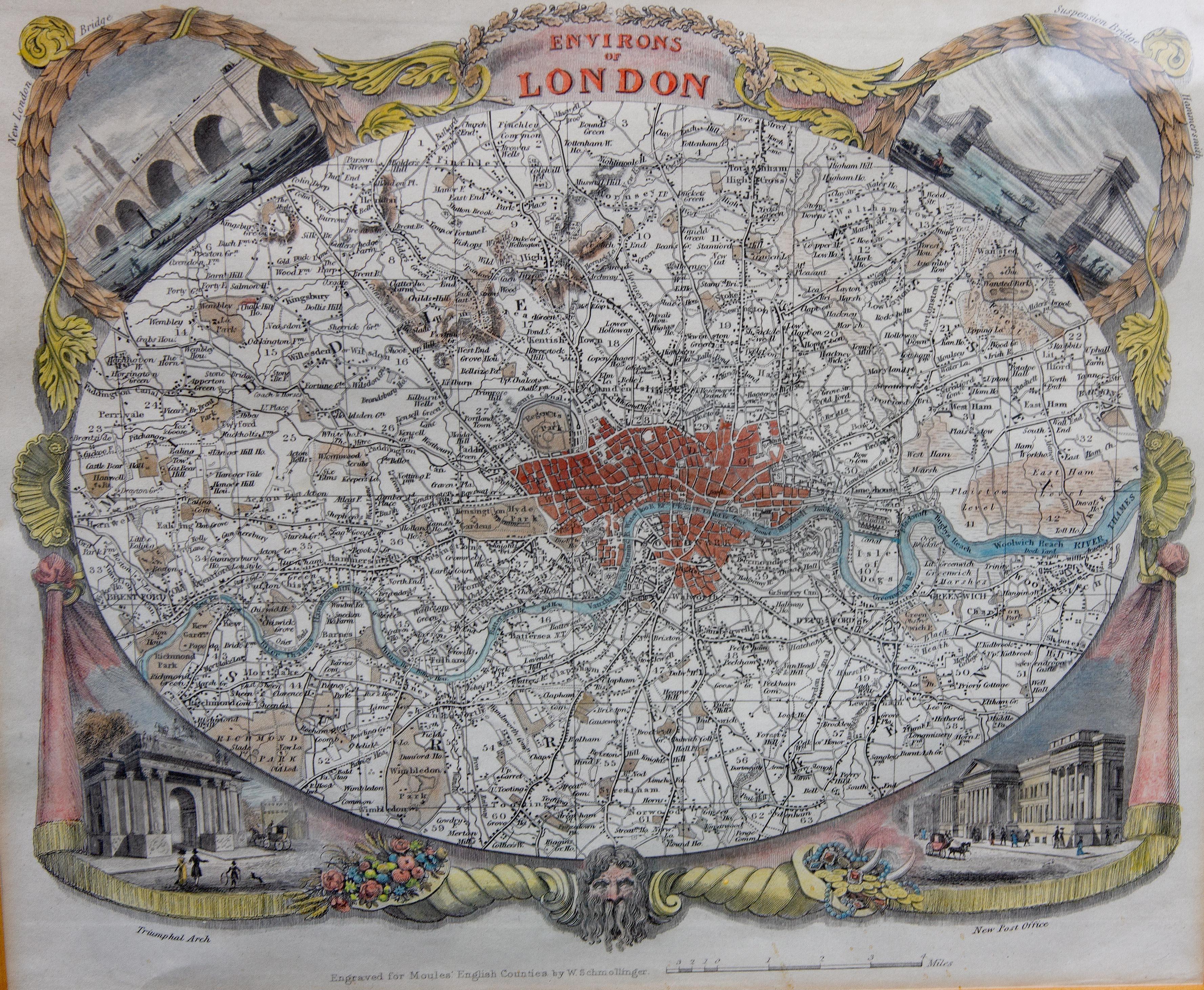
Antique Map of London by Thomas Moule and William Schmollinger
Located in Rochester, NY
Decorative engraved map of London by William Schmollinger for Moule's English County maps. Hand colored. Circa 1830's.
Category
Antique Early 19th Century English Prints
Materials
Paper

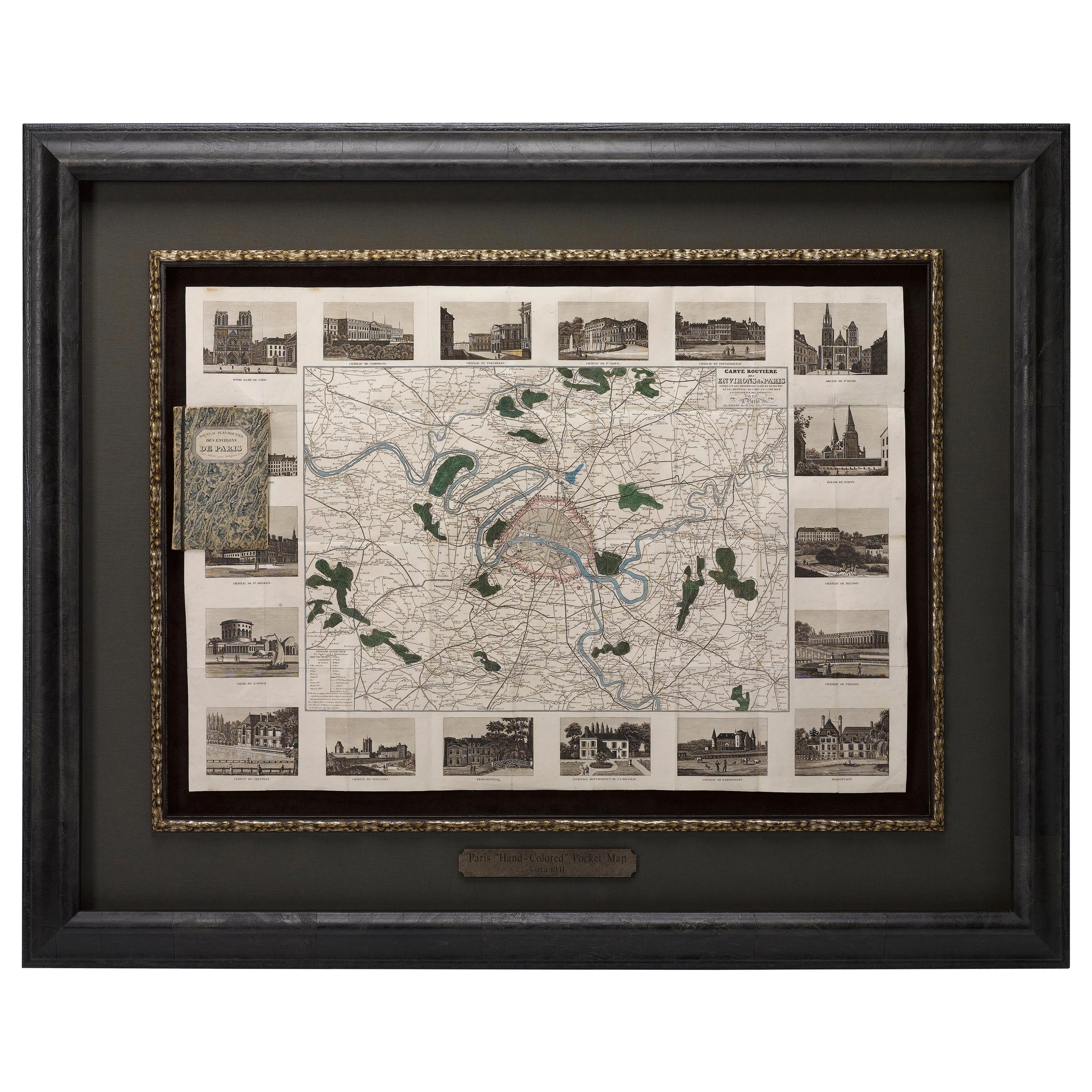
Antique Map of Paris, "Carte Routiere des Environs de Paris" 1841
Located in Colorado Springs, CO
This beautiful hand-colored road map of Paris was published in 1841. The map shows Paris and the surrounding area in a folding pocket map. Organized and detailed for travelers, this ...
Category
Antique 1840s French Maps
Materials
Paper

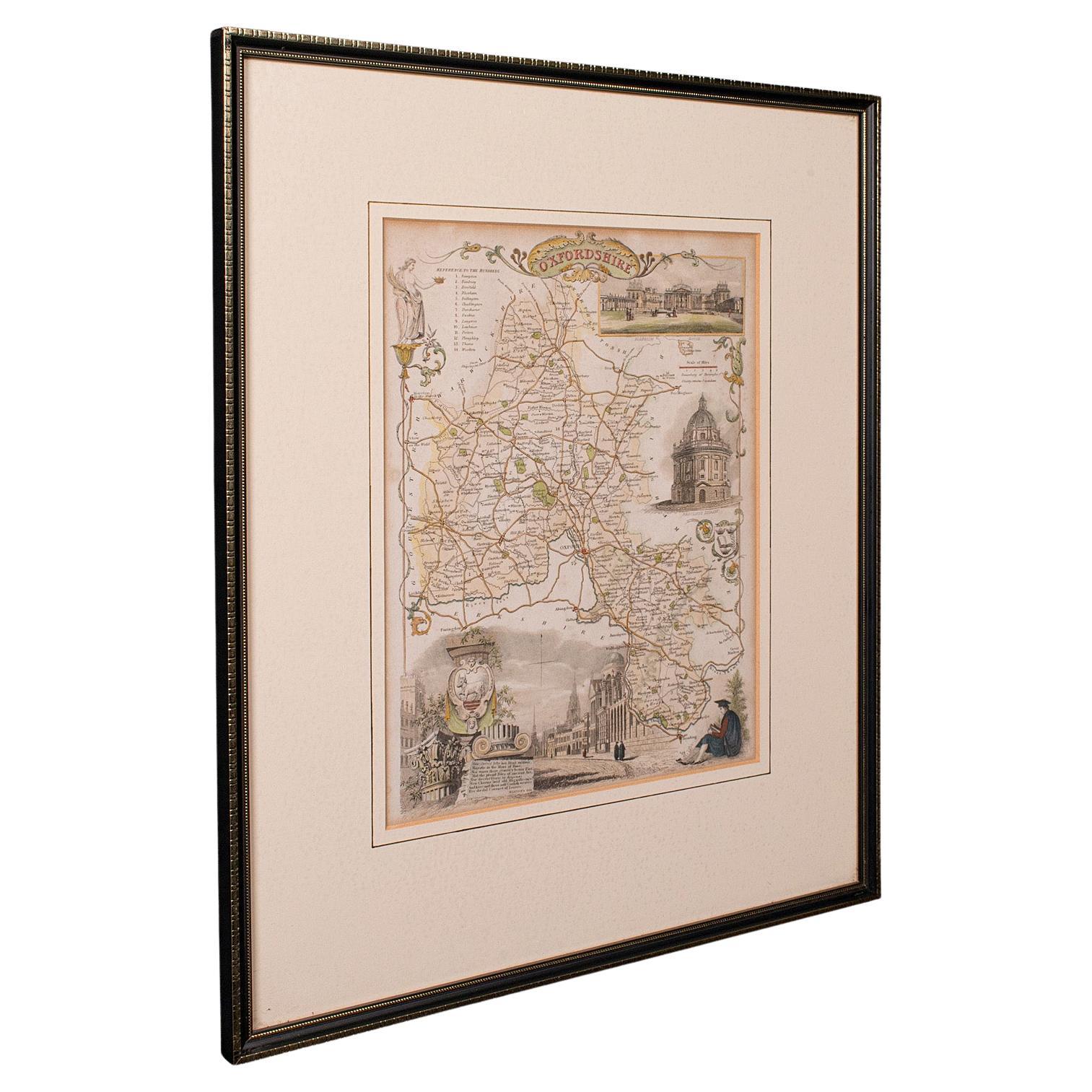
Antique County Map, Oxfordshire, English, Framed Cartography Interest, Victorian
Located in Hele, Devon, GB
This is an antique lithography map of Oxfordshire. An English, framed atlas engraving of cartographic interest, dating to the mid 19th century and later.
Superb lithography of Oxfo...
Category
Antique Mid-19th Century British Mid-Century Modern Maps
Materials
Wood

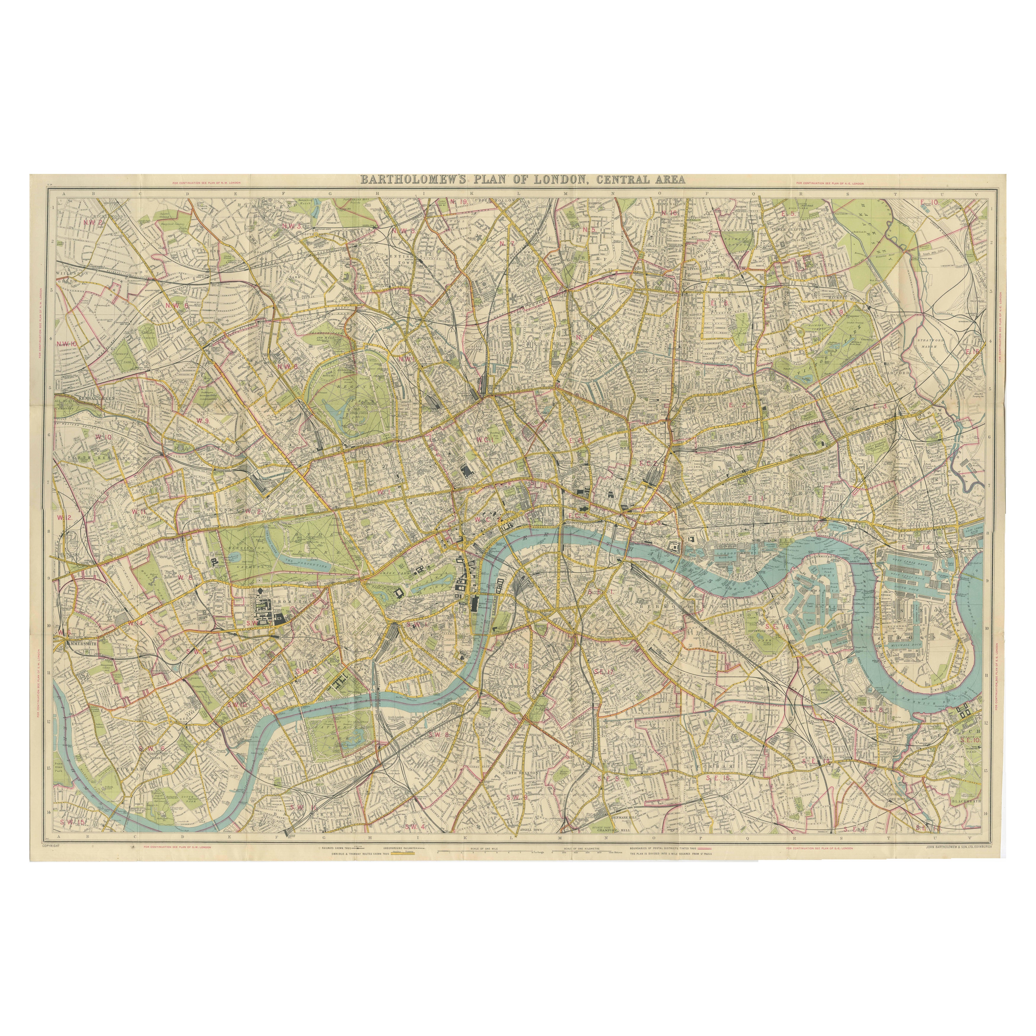
Vintage Map of London – Bartholomew’s Plan of Central London, c.1929
Located in Langweer, NL
London Central Map c.1929 – Bartholomew Antique City Plan
This detailed city plan, titled “Bartholomew’s Plan of London, Central Area,” was published by John Bartholomew & Son, Edin...
Category
Early 20th Century Scottish Maps
Materials
Paper
Map of Essex by Emanuel Bowen
Located in Cheshire, GB
Map of part of Essex and part of Kent, hand-coloured. Encased in an ebonized and gilded frame.
Dimensions
Height 25.5 Inches
Length 32.5 Inches
width 1 Inches.
Category
Antique Late 19th Century British Maps
Materials
Paper

$986 Sale Price
50% Off
Antique Lithography Map, Buckinghamshire, English, Framed Cartography, Victorian
Located in Hele, Devon, GB
This is an antique lithography map of Buckinghamshire. An English, framed atlas engraving of cartographic interest, dating to the mid 19th century and later.
Superb lithography of B...
Category
Antique Mid-19th Century British Victorian Maps
Materials
Wood, Paper

More Ways To Browse
The Vintage Map
Large Vintage Map
Post Modern High Chairs
Vintage Vine Rug
Silver Metal Chair
Swedish Kilim
Vintage Scandanavian Chairs
Vintage Tropical Furniture
19th Century Red Glass
Antique French Console Table Tables
French 50s
Rusted Metal Art
Silver Bowl Large
Antique French Silk
Down Couch
Cobalt Blue Glass
Used Lighter Art
Blue Edge Glass