Items Similar to Rare 1699 Map of the Failed Scottish Colony of Caledonia in Panama


Want more images or videos?
Request additional images or videos from the seller
1 of 10
Rare 1699 Map of the Failed Scottish Colony of Caledonia in Panama
$694.18
£512.07
€580
CA$961.83
A$1,044.36
CHF 553.06
MX$12,800.82
NOK 6,844.37
SEK 6,467.57
DKK 4,415.46
About the Item
Rare 1699 Map of the Failed Scottish Colony of Caledonia in Panama
This scarce and historically fascinating map, titled 'The Scots Settlement in America or New Caledonia A.D. 1699', documents the short-lived and ill-fated Scottish attempt to establish a colony on the Isthmus of Panama. The venture, known as the Darien Scheme, was one of Scotland’s most ambitious colonial enterprises—and ultimately, one of its most disastrous. The map was based on an original drawing by R. M. of the Company of Scotland and captures the strategic geography of the Bay of Caledonia and the surrounding settlements with remarkable clarity.
The engraving shows the narrow isthmus coastline of the Darién province with key geographical features labeled, including Golden Island, Point Look Out, The Inward Bay, and The Outward Bay of Caledonia. Several locations are named in hopeful homage to Scotland’s heritage, such as New Edinburgh, Caledonia, and Mount St. John. In the upper right corner, an inset text describes the location and explains the colony’s intended advantages for trade and its eventual desertion.
The Darien Scheme was launched in 1698 by the Company of Scotland, which hoped to create a trading hub linking the Atlantic and Pacific Oceans. However, plagued by poor planning, disease, lack of supplies, and Spanish hostility, the colony collapsed within a year. The financial losses were devastating and played a pivotal role in Scotland’s decision to join the 1707 Act of Union with England.
This map is a rare and poignant artifact of colonial ambition, Scottish nationalism, and one of the most consequential financial miscalculations in Scottish history.
Condition:
Very good condition considering the age, with clear impressions and light hand coloring. Margins are clean and the sheet has been professionally mounted in a neutral museum mat. There are only minor age-related spots and slight toning, adding to the antique character.
Framing Tips:
This piece is already attractively matted and would suit a dark wood or black frame with a subtle gold bevel to highlight the historic tone. Ideal for collectors of early colonial history, Scottish heritage, or rare Americana.
- Dimensions:Height: 18.27 in (46.4 cm)Width: 15.56 in (39.5 cm)Depth: 0.01 in (0.2 mm)
- Materials and Techniques:Paper,Engraved
- Place of Origin:
- Period:Late 17th Century
- Date of Manufacture:1699
- Condition:Very good condition considering the age, with clear impressions and light hand coloring. Margins are clean and the sheet has been professionally mounted in a neutral museum mat. Folding line as issued.
- Seller Location:Langweer, NL
- Reference Number:Seller: BG-140301stDibs: LU3054345435512
About the Seller
5.0
Recognized Seller
These prestigious sellers are industry leaders and represent the highest echelon for item quality and design.
Platinum Seller
Premium sellers with a 4.7+ rating and 24-hour response times
Established in 2009
1stDibs seller since 2017
2,622 sales on 1stDibs
Typical response time: <1 hour
- ShippingRetrieving quote...Shipping from: Langweer, Netherlands
- Return Policy
Authenticity Guarantee
In the unlikely event there’s an issue with an item’s authenticity, contact us within 1 year for a full refund. DetailsMoney-Back Guarantee
If your item is not as described, is damaged in transit, or does not arrive, contact us within 7 days for a full refund. Details24-Hour Cancellation
You have a 24-hour grace period in which to reconsider your purchase, with no questions asked.Vetted Professional Sellers
Our world-class sellers must adhere to strict standards for service and quality, maintaining the integrity of our listings.Price-Match Guarantee
If you find that a seller listed the same item for a lower price elsewhere, we’ll match it.Trusted Global Delivery
Our best-in-class carrier network provides specialized shipping options worldwide, including custom delivery.More From This Seller
View AllAntique Map of New Ireland, 1774
Located in Langweer, NL
Antique print titled 'Neu Irrland (..)'. Antique map of New Ireland with 7 coastal profiles, Papua New Guinea. Originates from 'Geschichte der See-Reisen u...
Category
Antique 18th Century Maps
Materials
Paper

$277 Sale Price
20% Off
Antique Map of a Bay on the Coast of Chile, South America, c.1749
Located in Langweer, NL
Antique map titled 'Plan van een Baai en Haven aan de Kust van Chili (..) - Plan d'une Baye de la Côte du Chili (..)'. Original antique map of a bay on the coast of Chile discovered ...
Category
Antique 18th Century Maps
Materials
Paper

$306 Sale Price
20% Off
Antique Map of the Bay of Bantam, c.1720
Located in Langweer, NL
Rare, untitled miniature map of the Bay of Bantam with various Islands including Pulo Dua and Pulo Batto. This map originates from a small travelogue and may originate from an editio...
Category
Antique 18th Century Maps
Materials
Paper

$57 Sale Price
20% Off
Antique Map of Coiba Island, Panama, South America, C.1740
Located in Langweer, NL
Antique map titled 'Plan de la partie orientale de l'Isle de Quibo'. Map of the eastside of Coiba Island (Quibo), Panama, showing the shoreline around Port de Dames indicating soft s...
Category
Antique 18th Century Maps
Materials
Paper

$325 Sale Price
20% Off
Antique Map of Anjouan Island by Valentijn, 1726
By F. Valentijn
Located in Langweer, NL
Antique map titled 'Anzuany'. This map depicts the island of Anjouan, one of the Comoros islands situated between Madagascar and Africa. The map is oriented with north to the left wi...
Category
Antique Early 18th Century Dutch Maps

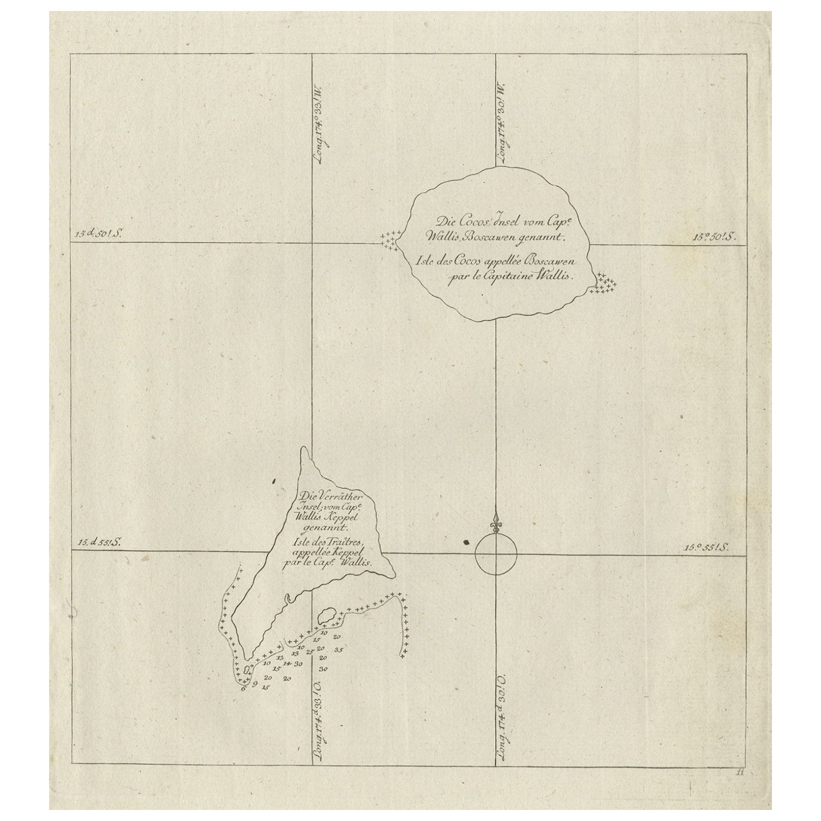
Antique Map of the Cocos or Keeling Islands, 1778
Located in Langweer, NL
Antique map titled 'Die Cocos Insel vom Capt. Wallis Bosawren. Die Verrather Islel von Capt. Wallis Keppel Genannt'. Also with French subtitles. Old map of the Cocos or Keeling Islan...
Category
Antique 18th Century Maps
Materials
Paper
$277 Sale Price
20% Off
You May Also Like
Ancient Map - Zeilan - Etching by Johannes Janssonius - 1650s
By Johannes Janssonius
Located in Roma, IT
Ancient Map - Zeilan is an ancient map realized in 1650 by Johannes Janssonius (1588-1664).
The Map is Hand-colored etching, with coeval watercoloring.
...
Category
1650s Modern Figurative Prints
Materials
Etching

Map of Scotland - Etching by Johannes Blaeu - 1650s
Located in Roma, IT
Map of Scotland is an geographic map realized by Johannes Blaeu.
Etching, printed in 1660 ca.
Copper engraving, colored (coeval coloring), on paper, with center fold;
Latin text. ...
Category
1650s Modern Figurative Prints
Materials
Etching
$448 Sale Price
20% Off
Antique Map - Gallia - Etching by Johannes Janssonius - 1650s
By Johannes Janssonius
Located in Roma, IT
Antique Map - Gallia is an antique map realized in 1650 by Johannes Janssonius (1588-1664).
The Map is Hand-colored etching, with coeval watercoloring.
Good conditions with slight ...
Category
1650s Modern Figurative Prints
Materials
Etching

1627 Hendrik Hondius Map Entitled "Vltoniae Orientalis Pars, " Ric.a009
Located in Norton, MA
1627 Hendrik Hondius map entitled
"Vltoniae orientalis pars,"
Ric.a009
Title:
Vltoniae orientalis : pars
Title (alt.) :
Ultoniae orientalis pars
Creator:
Mercator, Gerh...
Category
Antique 17th Century Dutch Maps
Materials
Paper

1654 Joan Blaeu Map the Sutherland, Scotland, Entitled "Southerlandia, "Ric0007
Located in Norton, MA
1654 Joan Blaeu map of the
Sutherland, Scotland, entitled
"Southerlandia,"
Hand Colored
Ric0007
Description:
Lovely map centered on Sedan and D...
Category
Antique 17th Century Dutch Maps
Materials
Paper

Rugen Island, Germany: An Early 17th Century Map by Mercator and Hondius
By Gerard Mercator
Located in Alamo, CA
This is an early 17th century map entitled "Nova Famigerabilis Insulae Ac Ducatus Rugiae Desciptio" (Map of Rugen Island, Germany) by Gerard Mercator and Henricus and Joducus Hondiu...
Category
Early 17th Century Old Masters Landscape Prints
Materials
Engraving

More Ways To Browse
Rare Artifact
17th Century Scottish
17th Century Scottish Furniture
Paisley Rugs and Carpets
Black And Chrome Lounge Chair
Vintage 1930 Dining Room Set
Antique Victorian Dining Tables
Environment Furniture
Italian Plastic Chairs
Made In Belgium
Black Crystal Glasses
French Mid Century Modern Rug
China Silk Rug
Chrome Glass Coffee Tables
Antique Italian Chairs
Antique Walnut Bar
Beni Ourain Rugs
French Iron And Glass Table