Items Similar to Small Map of Bantam with Dutch Ships and an Engraving of Portugese, 1614


Want more images or videos?
Request additional images or videos from the seller
1 of 8
Small Map of Bantam with Dutch Ships and an Engraving of Portugese, 1614
$716.16
$895.2020% Off
£534.37
£667.9620% Off
€600
€75020% Off
CA$998.65
CA$1,248.3220% Off
A$1,094.38
A$1,367.9820% Off
CHF 571.51
CHF 714.3920% Off
MX$13,151.46
MX$16,439.3220% Off
NOK 7,144.85
NOK 8,931.0620% Off
SEK 6,738.73
SEK 8,423.4120% Off
DKK 4,567.90
DKK 5,709.8720% Off
About the Item
Two rare old miniature copper-engravings one one leaf. One showing the first arrival of the first Dutch in Indonesia, the so-called 'Houtman expedition' and on the reverse Portugese welcoming them with gifts.
The First Dutch Expedition to Indonesia was an expedition that took place from 1595 to 1597. It was instrumental in the opening up of the Indonesian spice trade to the merchants that eventually formed the Dutch East India Company, and marked the end of the Portuguese Empire’s dominance in the region. Although the expedition did not bring back as much as expected – 245 bags of pepper, 45 tons of nutmeg, and 30 bales of mace – spice prices had become so inflated that the expedition was still profitable. All in all, the voyage suffered from bad leadership, but was still instrumental in opening up the East Indies to the Dutch
Artists and Engravers: During this voyage Cornelis de Houtman (1565-1599) emerged as the leader of the expedition. He was the brother of Frederick de Houtman, a Dutch explorer who discovered a new sea route from Europe to Indonesia and managed to begin the Dutch spice trade.
From the Johan Isaac Pontanus & J. Hondius edition of 1614 - 'Historische beschrijvinghe der seer wijt beroemde coop-stadt Amsterdam'.
creator: Anoniem / Anonymous(engraver / etcher), Lodewijcksz, Willem(copied after)
period: 1614
material: paper
technique: engraving
measurements sheet: 9.5 x 7 inch ( 24 x 18 cm)
measurement map: 5.3 x 3.3 inch ( 13,5 x 8.5 cm ) - the engraving of the Portugese is almost an inch bigger
The condition of the engravings itself is very good, Dutch text accompanying the engravings. The area around the engravings has (water) damage, brown spots and borders of the leaf are scuffy. Study the image of the larger leaf carefully.
- Dimensions:Height: 7.09 in (18 cm)Width: 9.45 in (24 cm)Depth: 0 in (0.02 mm)
- Materials and Techniques:
- Period:Early 17th Century
- Date of Manufacture:1614
- Condition:
- Seller Location:Langweer, NL
- Reference Number:Seller: BG-13098-3 & BG-13098-3A1stDibs: LU3054325979082
About the Seller
5.0
Recognized Seller
These prestigious sellers are industry leaders and represent the highest echelon for item quality and design.
Platinum Seller
Premium sellers with a 4.7+ rating and 24-hour response times
Established in 2009
1stDibs seller since 2017
2,655 sales on 1stDibs
Typical response time: <1 hour
- ShippingRetrieving quote...Shipping from: Langweer, Netherlands
- Return Policy
Authenticity Guarantee
In the unlikely event there’s an issue with an item’s authenticity, contact us within 1 year for a full refund. DetailsMoney-Back Guarantee
If your item is not as described, is damaged in transit, or does not arrive, contact us within 7 days for a full refund. Details24-Hour Cancellation
You have a 24-hour grace period in which to reconsider your purchase, with no questions asked.Vetted Professional Sellers
Our world-class sellers must adhere to strict standards for service and quality, maintaining the integrity of our listings.Price-Match Guarantee
If you find that a seller listed the same item for a lower price elsewhere, we’ll match it.Trusted Global Delivery
Our best-in-class carrier network provides specialized shipping options worldwide, including custom delivery.More From This Seller
View AllAntique Map of the Bay of Bantam, c.1720
Located in Langweer, NL
Rare, untitled miniature map of the Bay of Bantam with various Islands including Pulo Dua and Pulo Batto. This map originates from a small travelogue and may originate from an editio...
Category
Antique 18th Century Maps
Materials
Paper

$57 Sale Price
20% Off
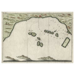
Small Early 18th Century Map of Banten Bay on the Island Java, Indonesia, c.1725
Located in Langweer, NL
A small early 18th century map of Banten Bay showing the islands of Pulo Dua and Pulo Batto together with soundings within the Bay and profiles of hills on the islands published by C...
Category
Antique 1720s Maps
Materials
Paper
$210 Sale Price
20% Off
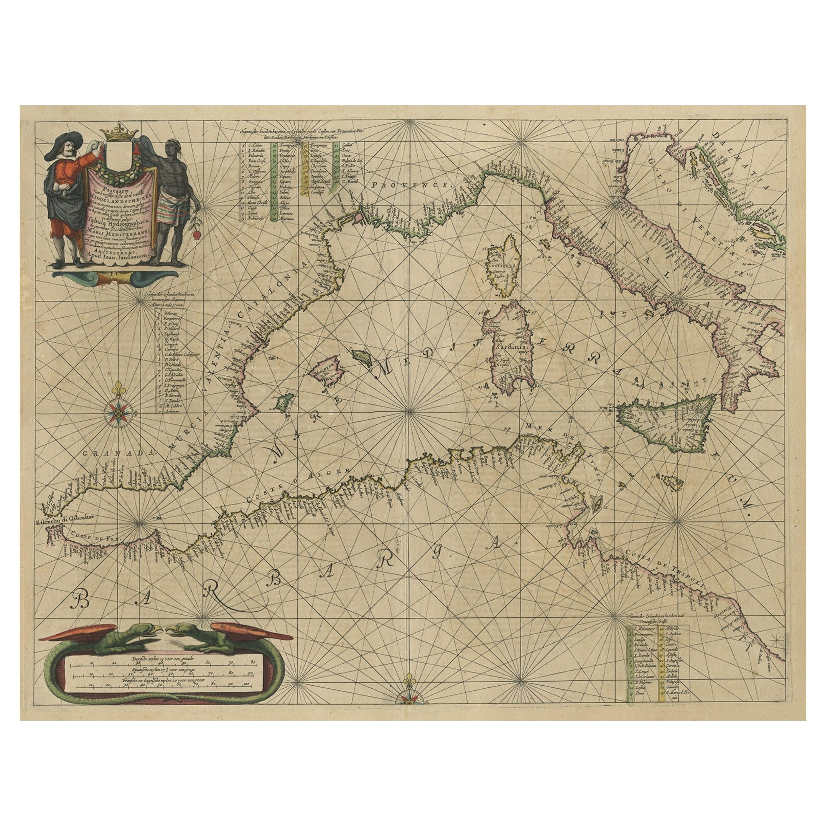
Original Antique Engraving of a Sea Chart of the Western Mediterranean, ca.1650
Located in Langweer, NL
Antique map titled 'Pascaerte van 't westlyckste deel vande Middelandsche-Zee (..)'.
Sea chart of the Western Mediterranean. The map extends from the Straits of Gibralter to Italy ...
Category
Antique 1650s Maps
Materials
Paper

$1,193 Sale Price
20% Off
Antique Map of the Bay of Batavia by Van der Aa, c.1720
Located in Langweer, NL
Antique map titled 'La Rade de Batavia'. A small early 18th century black and white map of the Bay of Batavia (Jakarta), Indonesia. Published by P....
Category
Antique 18th Century Maps
Materials
Paper

$257 Sale Price
20% Off
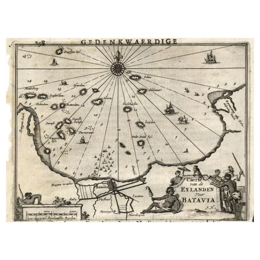
Antique Map of the Islands Near Batavia, Capital of the Dutch East Indies, 1682
Located in Langweer, NL
Antique map titled 'Caerte van de Eylanden voor Batavia.'
Map of the islands near Batavia, Indonesia. With scale, compass rose, cartouche and ships on the sea. Sheet with engraving...
Category
Antique 17th Century Maps
Materials
Paper

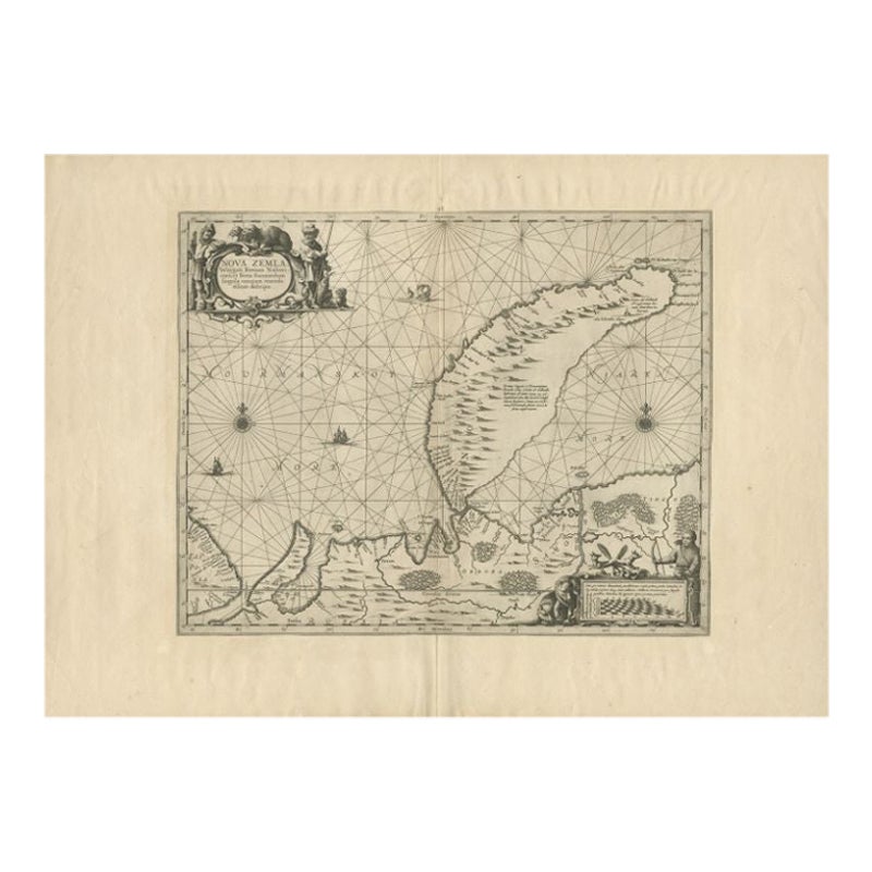
Antique Map of Nova Zembla by Janssonius, c.1650
Located in Langweer, NL
Antique map titled 'Nova Zemla, waygats fretum Nassovi cum et terra Samoiedum singula omnium emendatissime descripta'. This map depicts Nova Zembla and the northern continental coast...
Category
Antique 17th Century Maps
Materials
Paper

$379 Sale Price
20% Off
You May Also Like
Ancient Map - Zeilan - Etching by Johannes Janssonius - 1650s
By Johannes Janssonius
Located in Roma, IT
Ancient Map - Zeilan is an ancient map realized in 1650 by Johannes Janssonius (1588-1664).
The Map is Hand-colored etching, with coeval watercoloring.
...
Category
1650s Modern Figurative Prints
Materials
Etching

Antique Map - Mare Pacificum - Etching by Johannes Janssonius - 1650s
By Johannes Janssonius
Located in Roma, IT
Mare Pacificum is an antique map realized in 1650 by Johannes Janssonius (1588-1664).
The Map is Hand-colored etching, with coeval watercolorang.
Good conditions with slight foxing...
Category
1650s Modern Figurative Prints
Materials
Etching

1646 Jansson Map Entitled "Procinvia Connactiae, " Ric.a006
Located in Norton, MA
1646 Jansson map entitled
"Procinvia connactiae,"
Ric.a006
Description: The PROVINCE of CONNAVGT 490 x 380From vol 4 of Jansson's Atlas Novus 1646, published in Amsterdam with...
Category
Antique 17th Century Unknown Maps
Materials
Paper

Antique Map - Gallia - Etching by Johannes Janssonius - 1650s
By Johannes Janssonius
Located in Roma, IT
Antique Map - Gallia is an antique map realized in 1650 by Johannes Janssonius (1588-1664).
The Map is Hand-colored etching, with coeval watercoloring.
Good conditions with slight ...
Category
1650s Modern Figurative Prints
Materials
Etching

Antique Map - Archipela Meridionalis - Etching by Johannes Janssonius - 1650s
By Johannes Janssonius
Located in Roma, IT
Antique Map - Archipela Meridionalis is an antique map realized in 1650 by Johannes Janssonius (1588-1664).
The Map is Hand-colored etching, with coeval watercolorang.
Good conditi...
Category
1650s Modern Figurative Prints
Materials
Etching

Rugen Island, Germany: An Early 17th Century Map by Mercator and Hondius
By Gerard Mercator
Located in Alamo, CA
This is an early 17th century map entitled "Nova Famigerabilis Insulae Ac Ducatus Rugiae Desciptio" (Map of Rugen Island, Germany) by Gerard Mercator and Henricus and Joducus Hondiu...
Category
Early 17th Century Old Masters Landscape Prints
Materials
Engraving

More Ways To Browse
Dutch East India Company
Dutch Engravings
Holland And Company
Dutch Ship
17th Century Ship
Antique Nutmeg
Antique Texas Furniture
Military Map
Antique Maps New Zealand
Birds Eye View Map
North Africa Map
West Africa Map
Antique Compass Map
Antique Maps California
Biblical Maps
Hungary Map
Maps Of Mediterranean
Treasure Map