Items Similar to Uncommon, Large Map of the British Islands to Petshora Bay, 1891

Want more images or videos?
Request additional images or videos from the seller
1 of 5
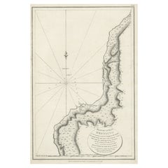
Uncommon, Large Map of the British Islands to Petshora Bay, 1891
About the Item
Antique map titled 'British Islands to Petshora Bay - White Sea'. Uncommon, large map of the British Islands to Petshora Bay. It shows the White Sea and inset maps of Onega Road, Onega Bay, Sem Islands, Iukanskie and Nokuev Island.
Artists and Engravers: Published by James Imray and Son.
- Dimensions:Height: 42.13 in (107 cm)Width: 27.56 in (70 cm)Depth: 0 in (0.02 mm)
- Materials and Techniques:
- Period:
- Date of Manufacture:1891
- Condition:Condition: Good, general age-related toning. Small defect/split in center of the folding lines, blank verso. Please study image carefully.
- Seller Location:Langweer, NL
- Reference Number:
About the Seller
5.0
Platinum Seller
These expertly vetted sellers are 1stDibs' most experienced sellers and are rated highest by our customers.
Established in 2009
1stDibs seller since 2017
1,916 sales on 1stDibs
Typical response time: <1 hour
- ShippingRetrieving quote...Ships From: Langweer, Netherlands
- Return PolicyA return for this item may be initiated within 14 days of delivery.
More From This SellerView All
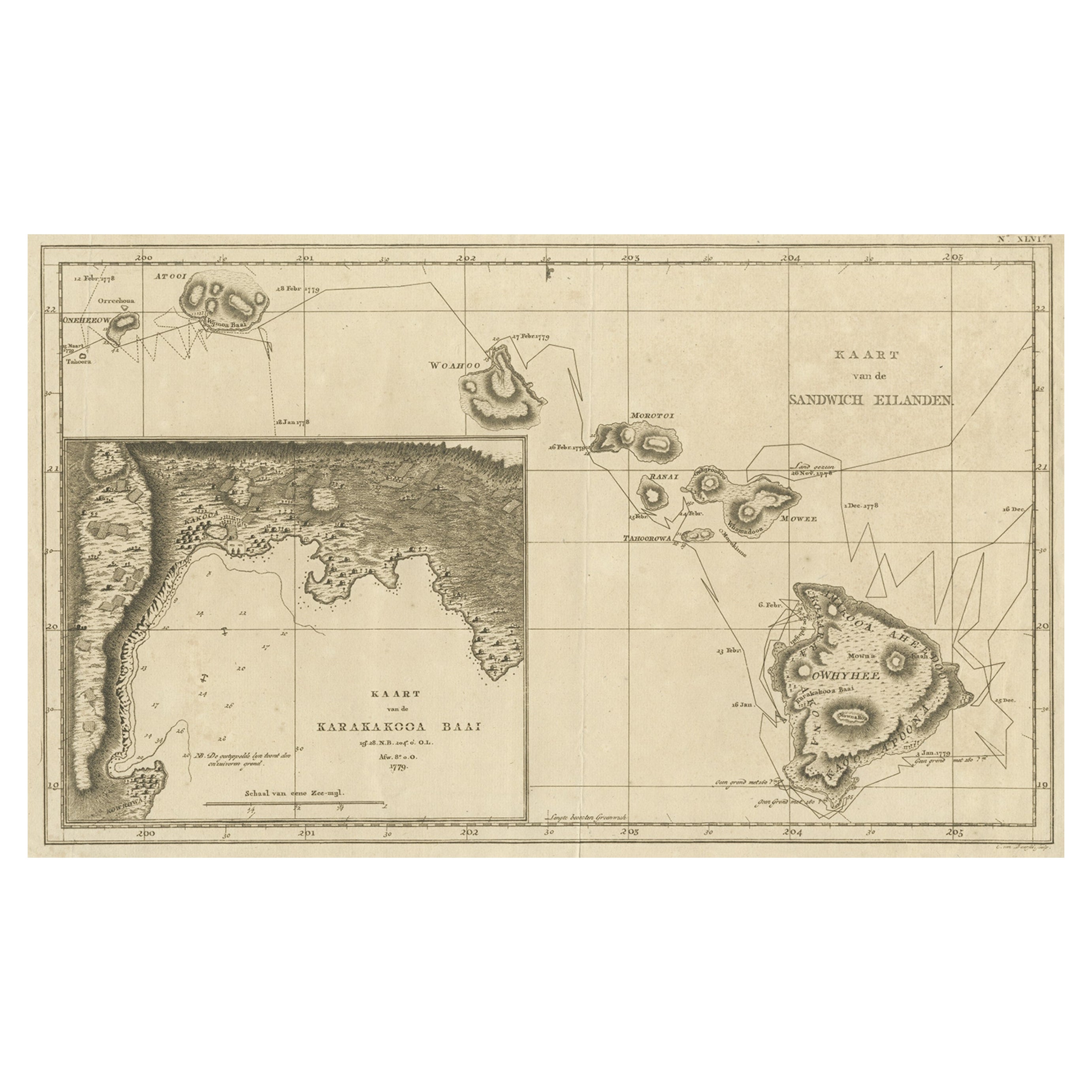
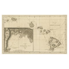
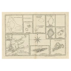
- Map of the Hawaiian Islands with a Large Inset of Karakakooa Bay, 1803Located in Langweer, NLAntique map titled 'Kaart van de Sandwich Eilanden'. Map of the Hawaiian Islands with a large inset of Karakakooa Bay, including soundings and anchorages. Originates from 'Reizen R...Category
Antique Early 1800s Maps
MaterialsPaper
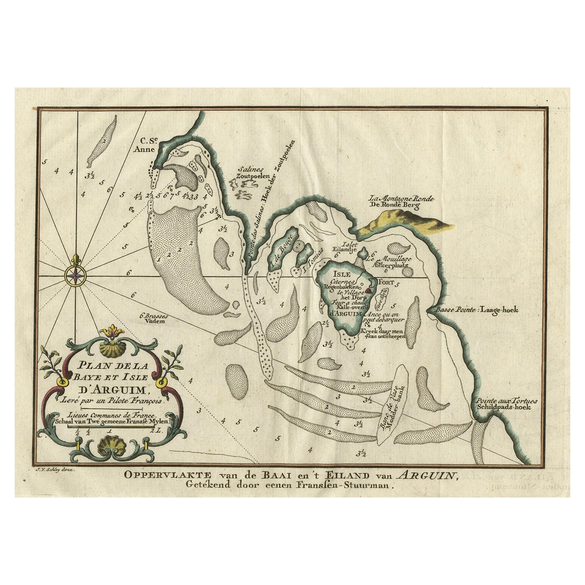
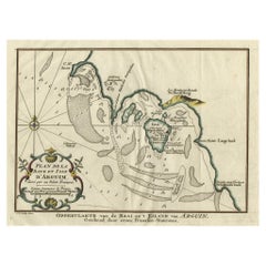
- Original Antique Map of the Bay and the Island of Arguin, Mauritania, 1747Located in Langweer, NLAntique map titled ’Plan de la Baye et Isle d'Arguim (..) - Oppervlakte van de Baai en 't Eiland van Arguin (..)'. Original antique map of the bay and the island of Arguin. This ...Category
Antique 1740s Maps
MaterialsPaper
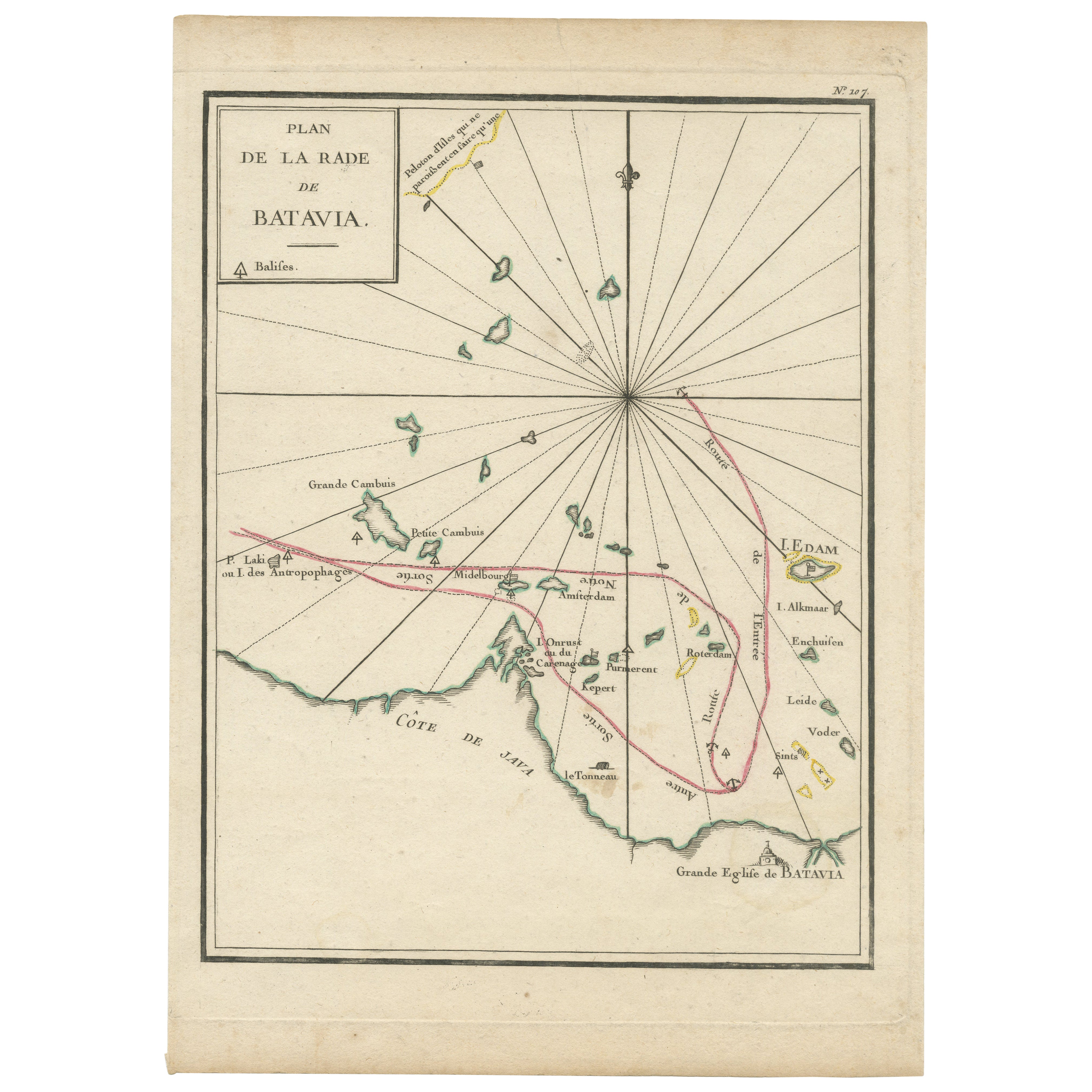
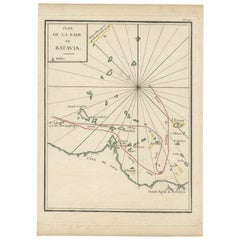
- Interesting Map of the Thousand Islands in the Bay of Batavia 'Jakarta', ca.1740Located in Langweer, NLA single unfolded page border colored engraved map, printed no. 107 in top corner. This same map is found as plate 107 in Atlas Universelle aus dem Jahre 1787 by Philippe de Pretot b...Category
Antique 1740s Maps
MaterialsPaper
- Large Sea Chart of the British Islands, 1918Located in Langweer, NLAntique map titled 'The British Islands'. Large sea chart of the British Islands. It shows Ireland, Scotland, England, the Shetland Islands and part of Fra...Category
Vintage 1910s Maps
MaterialsPaper
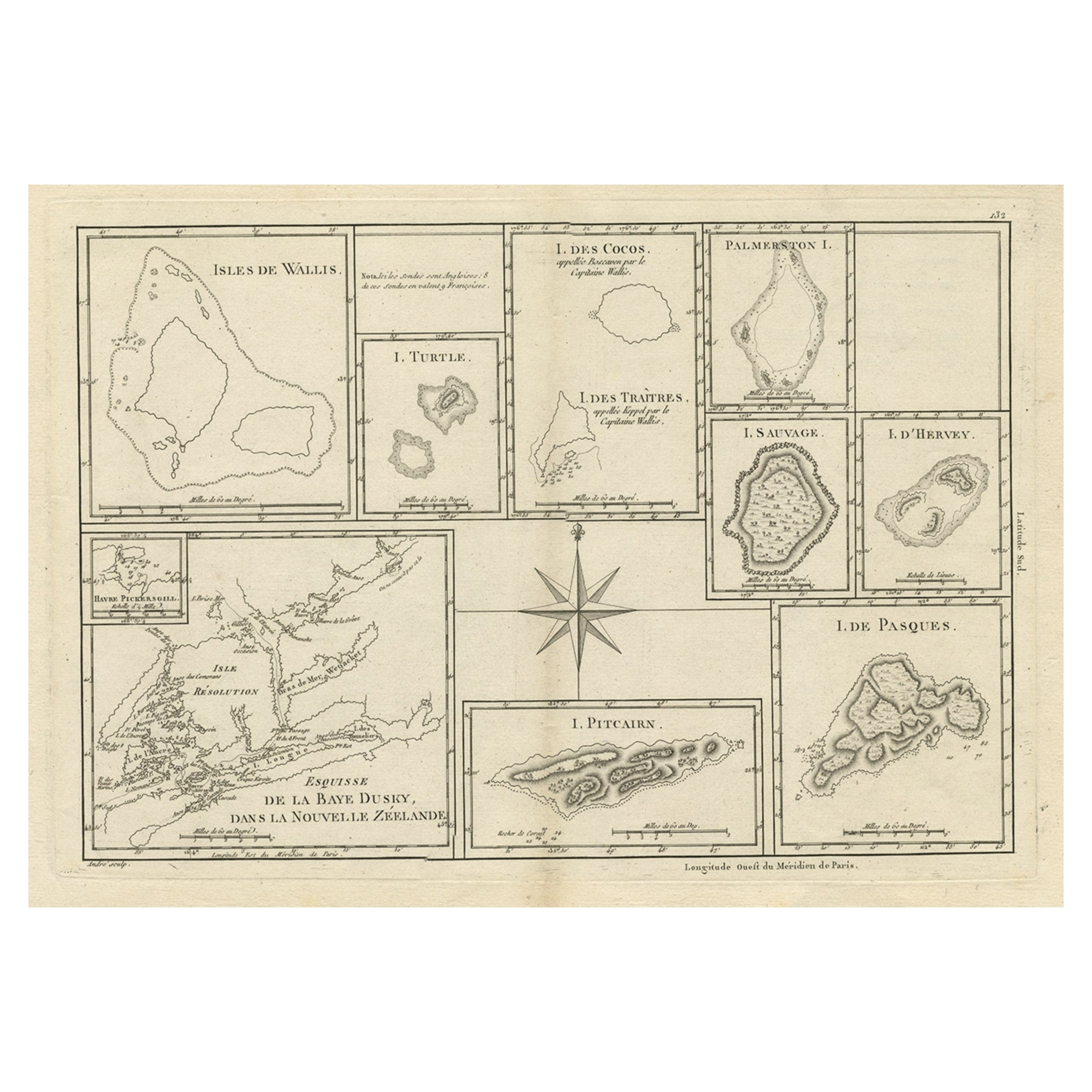
- Print of Maps of Islands of the South Pacific, Incl. Pitcairn & Dusky Bay, 1788Located in Langweer, NLAntique map titled 'Esquisse de la Bay Dusky, Dans La Nouvelle Zeelande / I. Pitcairn / Isles de Wallis / I Turtle / I des Cocos and Traitres / Palmerston I. / I. Suavage / I. D'Hervey/ Havre Pickersgill / I de Pasques.' Detailed set of maps of the islands of the South Pacific...Category
Antique 1780s Maps
MaterialsPaper
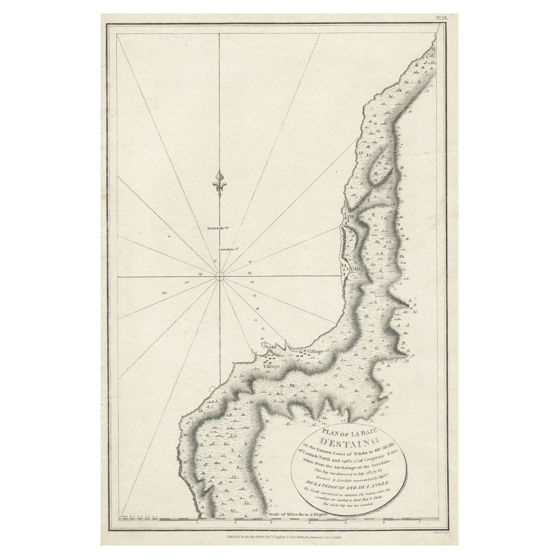
- Antique Map of The Bay of D'Estaing located on the Russian island Sakhalin, 1798Located in Langweer, NLAntique map titled 'Plan of La Baie d'Estaing'. This map shows the bay of D'Estaing located on the Russian island of Sakhalin. La Perouse was selected b...Category
Antique 1790s Maps
MaterialsPaper

You May Also Like
- Large 17th Century Hand Colored Map of England and the British Isles by de WitBy Frederick de WitLocated in Alamo, CAA large hand colored 17th century map of England and the British Isles by Frederick de Wit entitled "Accuratissima Angliæ Regni et Walliæ Principatus", published in Amsterdam in 1680. It is a highly detailed map of England, Scotland, the Scottish Isles...Category
Antique Late 17th Century Dutch Maps
MaterialsPaper
- Map of the Republic of GenoaLocated in New York, NYFramed antique hand-coloured map of the Republic of Genoa including the duchies of Mantua, Modena, and Parma. Europe, late 18th century. Dimension: 25...Category
Antique Late 18th Century European Maps
- Hand-Colored 18th Century Homann Map of Denmark and Islands in the Baltic SeaBy Johann Baptist HomannLocated in Alamo, CAAn 18th century copper plate hand-colored map entitled "Insulae Danicae in Mari Balthico Sitae utpote Zeelandia, Fionia, Langelandia, Lalandia, Falstria, Fembria Mona" created by Joh...Category
Antique Early 18th Century German Maps
MaterialsPaper
- Map "Estuary- Mouth of the Thames"Located in Alessandria, PiemonteST/426 - Antique French Map of the estuary of the Thames, map dated 1769 - "Mape of the entrance of the Thames. Designed by filing of Navy cards fo...Category
Antique Mid-18th Century French Other Prints
MaterialsPaper
- Large Antique 1859 Map of North AmericaLocated in Sag Harbor, NYThis Map was made by Augustus Mitchell in 1859 It is in amazing condition for being 163 years old. This price is for the rolled up easy to ship version of this piece. I will be Frami...Category
Antique Mid-19th Century American Maps
MaterialsCanvas, Paper

- England, Scotland & Ireland: A Hand Colored Map of Great Britain by TirionBy Isaak TirionLocated in Alamo, CAThis is a hand-colored double page copperplate map of Great Britain entitled "Nieuwe Kaart van de Eilanden van Groot Brittannien Behelzende de Kon...Category
Antique Mid-18th Century Dutch Maps
MaterialsPaper


Recently Viewed
View AllMore Ways To Browse
Antique Bay
Antique Britain Map
Antique Map Britain
Antique Road Maps
Antique Road Map
General Empire
Wood And Sons Plate
Antique Caribbean
Large World Map
Holland Utrecht
Antique Paper Globe
World Map Globe
Small Antique Globes
Antique Maps India
Antique Map India
India Antique Map
Antique India Map
Antique Maps Of India