Items Similar to Very Large Hand-Drawn View of St Iago Cape Verde, by Frederici, 1783


Want more images or videos?
Request additional images or videos from the seller
1 of 3
Very Large Hand-Drawn View of St Iago Cape Verde, by Frederici, 1783
$29,166.80
£21,678.87
€24,500
CA$40,271.33
A$44,657.93
CHF 23,464.43
MX$545,644.03
NOK 293,572.04
SEK 275,567.52
DKK 186,555.25
About the Item
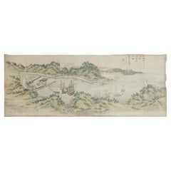
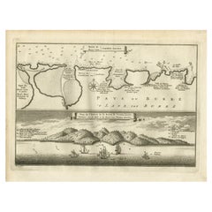
Johann Christian Friderici [= Frederici] (Heldburg 1766 - Cape Town 1804)
Prospect van het eyland, en de rheede van St. Iago. Geteekend van Johann Christian Friderici / Verbeelding van de inwoonders op St Iago
(View of the island, and the roadstead of St. Iago. Drawn by Johann Christian Friderci / Depiction of the inhabitants on St Iago)
?Porto Praia, Cape Verde, 1783.
Watercolour with ruled black ink border on laid paper, watermarked Pro Patria with Maid of Dort,
H. 29. 5 x W. 120.5 cm
The largest recorded early modern panoramic view of Cape Verde, by “the best VOC map maker in South Africa” (Koeman). This is his earliest known work.
Santiago’s Porto Praia is the main harbour of Cape Verde. It served as an important transportation hub for enslaved African people to the Americas and for the restocking of ships bound for the Cape with salt and fresh foods. These two functions of the island are depicted in the cartouche in the top right. It shows an African family and examples of livestock: a turkey and a goat. The man wears clothes that are also seen in depictions of plantation guards in the West Indies of the same period.
- Dimensions:Height: 11.62 in (29.5 cm)Width: 47.45 in (120.5 cm)Depth: 0.08 in (2 mm)
- Style:Dutch Colonial (Of the Period)
- Materials and Techniques:
- Place of Origin:Cape Verde
- Period:
- Date of Manufacture:1783
- Condition:Wear consistent with age and use. Can be framed. Some creases and folds, yellowed and some foxing - all not disruptive (can be restored on request).
- Seller Location:Amsterdam, NL
- Reference Number:1stDibs: LU5458229747982
About the Seller
5.0
Recognized Seller
These prestigious sellers are industry leaders and represent the highest echelon for item quality and design.
Established in 1985
1stDibs seller since 2020
23 sales on 1stDibs
Typical response time: 5 hours
- ShippingRetrieving quote...Shipping from: Amsterdam, Netherlands
- Return Policy
Authenticity Guarantee
In the unlikely event there’s an issue with an item’s authenticity, contact us within 1 year for a full refund. DetailsMoney-Back Guarantee
If your item is not as described, is damaged in transit, or does not arrive, contact us within 7 days for a full refund. Details24-Hour Cancellation
You have a 24-hour grace period in which to reconsider your purchase, with no questions asked.Vetted Professional Sellers
Our world-class sellers must adhere to strict standards for service and quality, maintaining the integrity of our listings.Price-Match Guarantee
If you find that a seller listed the same item for a lower price elsewhere, we’ll match it.Trusted Global Delivery
Our best-in-class carrier network provides specialized shipping options worldwide, including custom delivery.More From This Seller
View AllExtremely Large Hand-Drawn Manuscript Map of Surinam, 1830, History of Slavery
Located in Amsterdam, NL
A unique large hand-drawn map of Surinam by Albrecht Helmut Hiemcke (German, 1760-1839)
?
'Colonie Surinaame', 1830
A large hand-drawn and coloured map of the colony of Suri...
Category
Antique Mid-19th Century Surinamer Maps
Materials
Paper

Collection of Colonial Drawings Depicting Indonesia by J.G. Sinia '1875-1948'
Located in Amsterdam, NL
A Collection of Thirteen Ink and Chalk Drawings by Johan Gerard Sinia (1875-1948)
All framed in gilt-metal or giltwood frames
Sinia started his professional career as an army off...
Category
Early 20th Century Indonesian Dutch Colonial Paintings and Screens
Materials
Other
$29,762 / set
Free Shipping
Unpei Kameyama, 'a View of Black 'American' Ships in the Bay of Uraga Senminato'
Located in Amsterdam, NL
Unpei Kameyama (1821-1899)
A view of black (American) ships in the bay of Uraga Senminato, Miura district, June 1853
The Japanese text reads: ‘The seventy-six old men for the Kitamura-clan, drawn in 1897 on request of Yoshisada Kitamura, Himeji, the black ships which so much changed the fate of Japan, enjoy please this masterpiece by Harima Shonin Bisei who brings back memories of his young days.’
Watercolour on paper, laid down on cardboard, H. 44.5 x W. 115.5 cm
Provenance:
Collection of Yoshisada Kitamura, Himeji
Yoshisada Kitamura (1838-1899), the son of a farmer in the village of Ogawa, in the district of Harimakashikihigashi, studied under Matajiro Otaka and got heavily involved in the anti-Shogunate movement. He was active in several military incidents against the Shogunate. After the Meiji restoration, he served the Meiji government as a local official in the Himeji domain.
Kameyama Unpei was a Confucian scholar, a Shinto priest...
Category
Antique Mid-19th Century Japanese Edo Paintings and Screens
Materials
Paper
W.O.J. Nieuwenkamp (1874-1950) 'Wadah, Bali 1906’
Located in Amsterdam, NL
'Wadah, Bali 1906’
Signed upper right and with a pencil sketch annotated Boela(?), depot Stedelijk Museum Amsterdam and the artist’s stamp verso
Pen, brush and ink on paper laid do...
Category
Early 20th Century Indonesian Paintings and Screens
Materials
Paper
W.O.J. Nieuwenkamp (1874-1950) 'A Buginese boat, Semarang 1898’
Located in Amsterdam, NL
'A Buginese boat, Semarang 1898’
Signed, dated, and annotated, upper right Pen, brush and ink on cardboard, H. 11.4 x W. 26.3 cm
Literature:
Venselaar, 2019, p. 69 (ill.)
Category
Antique 19th Century Indonesian Paintings and Screens
Materials
Paper
'Two Dutch Ships Anchored in the Bay of Nagasaki' by Kawahara Keiga '1786-1860'
Located in Amsterdam, NL
Kawahara Keiga (1786 - c. 1860)
Two Dutch ships anchored in the bay of Nagasaki
Sumi ink and pigment on silk, H. 27 x W. 41 cm (excl. frame)
Comes framed, see image.
?Based o...
Category
Antique Early 19th Century Japanese Paintings and Screens
Materials
Silk
$101,190
Free Shipping
You May Also Like
Antique Map of the Coast of Cape Verde by J. Van Der Schley, circa 1750
Located in Langweer, NL
An early map of what is now the coast of the capital city of Dakar, Senegal. What is now a dense, bustling city was at this time a uninhabited coast. Shows the overall contours of th...
Category
Antique Mid-18th Century Maps
Materials
Paper

$152 Sale Price
20% Off
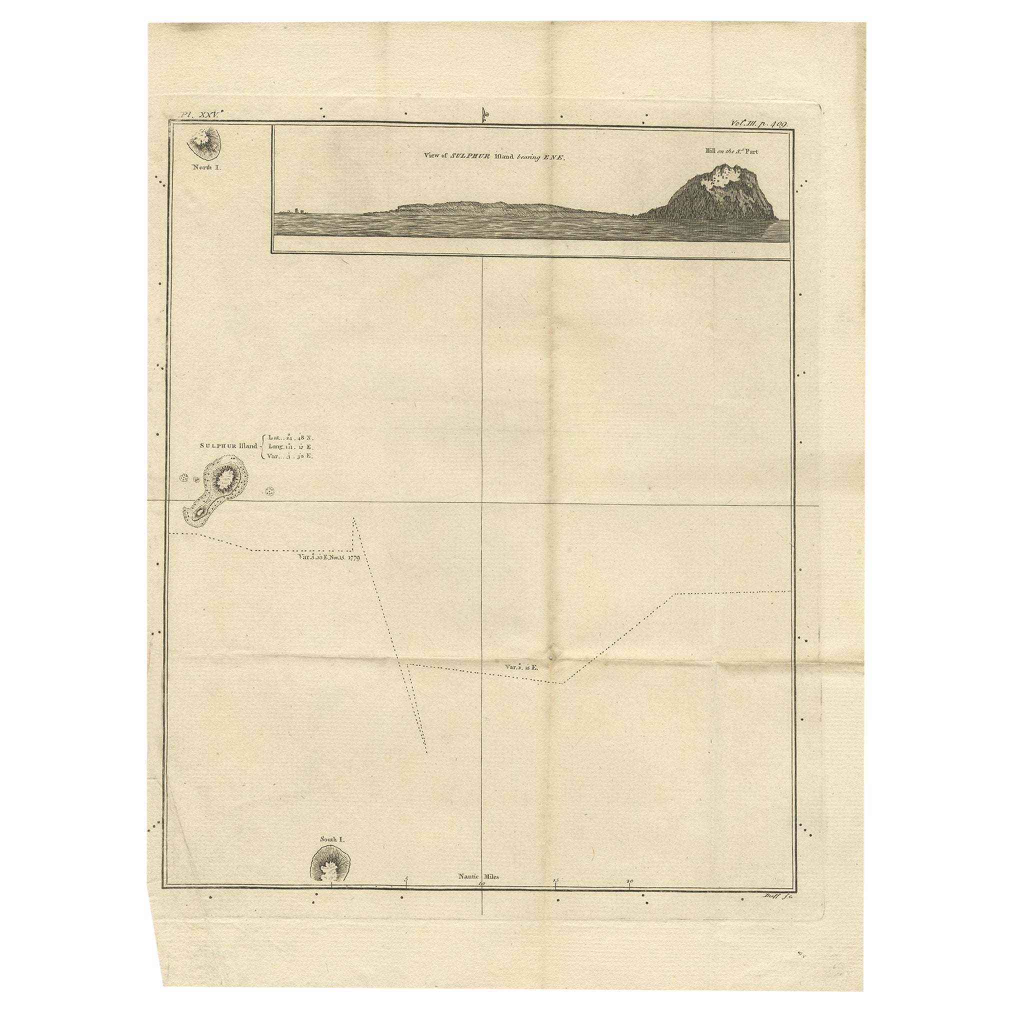
Antique Map of Suffren Island by Cook, c.1781
Located in Langweer, NL
Antique map titled 'View of Sulphur Island (..)'. Antique map and view of Suffren Island. Originates from an edition of Cook's Voyages.
Artists and Engravers: Engraved by Duff.
...
Category
Antique 18th Century Maps
Materials
Paper
$142 Sale Price
20% Off
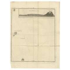
Antique Map of the Harbour of Praia, Santiago Island, Cape Verde, c.1750
Located in Langweer, NL
Antique map titled 'A Draught of ye Harbour of Praya in the Island St. Jago (..)'. Uncommon map showing the harbour of Praia on Santiago Island, Cape Verde. Source unknown, to be det...
Category
Antique 18th Century English Maps
Materials
Paper
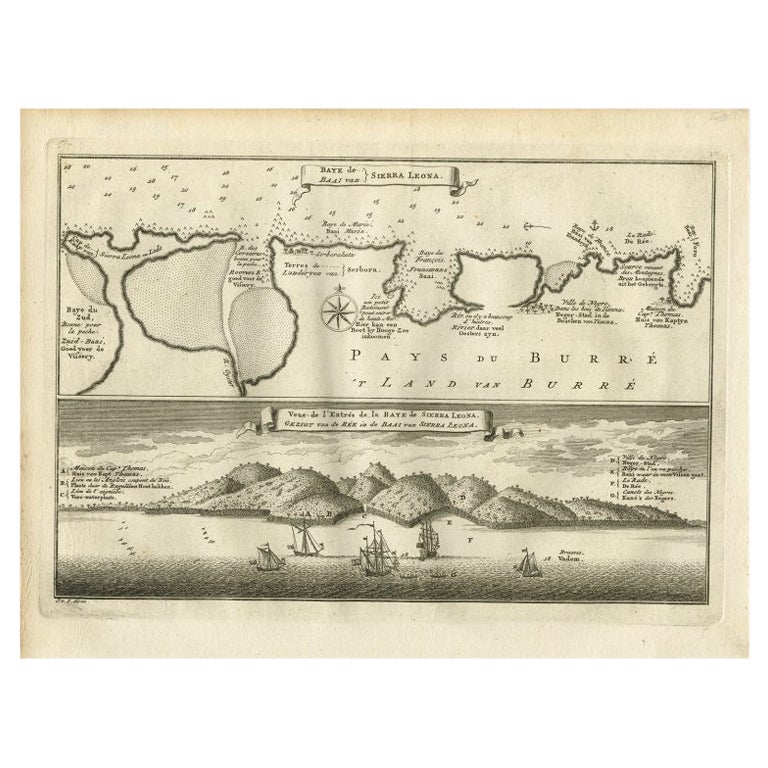
Antique Map and View of the Bay of Sierra Leone in Africa, C.1750
Located in Langweer, NL
Antique print titled 'Baye de Sierra Leona (..) - Baai van Sierra Leona (..)'. Map and view of the bay of Sierra Leone. This print originates from 'Historische beschryving der Reizen...
Category
Antique 18th Century Prints
Materials
Paper
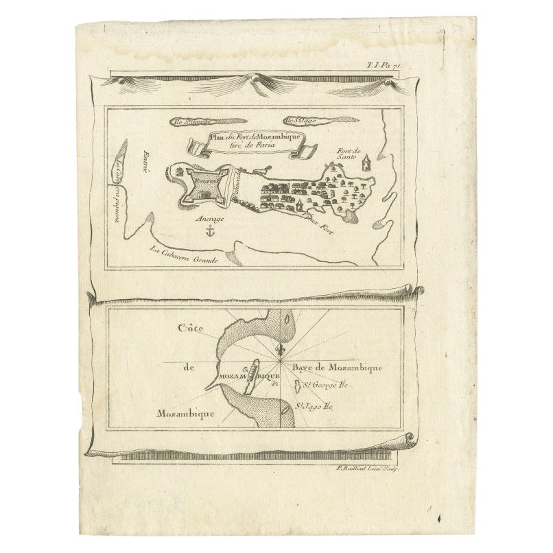
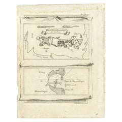
Antique Map of Mozambique Bay and a Map Fort de Mozambique, c.1759
Located in Langweer, NL
Two antique maps on one sheet. The upper antique map is titled 'Plan du Fort de Mozambique tiré de Faria' and depicts the island of Mozambique with its fort, settlement, harbor and i...
Category
Antique 18th Century Maps
Materials
Paper
$104 Sale Price
20% Off
Original Antique Map of the Cape Verde Islands, 1746
Located in Langweer, NL
Antique map titled 'Carte Des Isles Du Cap Verd.' Original antique map of the Cape Verde Islands. Decorative cartouche and compass rose. Extends from Isle d...
Category
Antique 18th Century Maps
Materials
Paper

$161 Sale Price
20% Off
More Ways To Browse
Antique South Africa
Cape Antique Furniture
Cape Dutch Furniture
Verde Antique Paint
Pro Patria
Antique Maps Of Maryland
Gambia Antique Map
Antique Manitoba
Antique Map Of Brooklyn
Antique Map Of Michigan
Cham Antiques
Map Of Native American Tribes
Antique Furniture Halifax Furniture
Antique Furniture Trinidad
Antique Kiel Furniture
Cornwall Map
Marie Galante
Patagonia Map