Items Similar to WWI Satirical Cartoon Map: 'Kill That Eagle' by J.H. Amschewitz, 1914

Want more images or videos?
Request additional images or videos from the seller
1 of 9
WWI Satirical Cartoon Map: 'Kill That Eagle' by J.H. Amschewitz, 1914
$2,690.14
£1,991.51
€2,250
CA$3,722.47
A$4,103.94
CHF 2,147.05
MX$50,347.76
NOK 27,027.11
SEK 25,274.63
DKK 17,139.12
About the Item
This fascinating serio-comic map was created by John Henry Amschewitz and published in December 1914, at the beginning of WWI.
Amschewitz was a British born artist who was unable to enlist for war service due to an injury he sustained while working on a mural project in Liverpool. Instead Amschewitz focused on his interests in art and theater, themes which are apparent in this map and even the title itself: European Revue.
The eagle refers of course to Germany, which has its claw on Marianne's bayonet, while its other claw is being pulled by the Russian bear. Austria is depicted as a clown with the head of an ass in one hand and Italy croons the song lyrics, "You made me love you, I didn't want to do it...," written by American Al Jolson and first published in 1913.
Britain is illustrated as a domineering John Bull accompanied by the words "Business as usual," a patriotic phrase coined by British businesses to indicate that business would continue in Britain despite the war. This map was later copied by German propagandists with a mis-interpretation of the phrase "business as usual" to prove Britain's war-mongering ways. Issued folding in original printed paper self-wrappers.
Although the human personification of continents and countries can be seen as early as the 14th century (on maps by Opicinus de Canestris), human and animal metaphors on maps reached a new level in Europe between 1845 and 1945 with political cartoon maps. The rise of these satirical maps reflected the momentous political and cultural changes that occurred during the time. Political leaders were caricaturized and European nations were given symbolic identities that lent humor and accessibility to the geographical map. Based on popular stereotypes, these visual representations even found their way into the classroom to help bring geography and politics to life. Original serio-comic maps are very scarce due to their ephemeral nature.
- Dimensions:Height: 19.41 in (49.3 cm)Width: 28.31 in (71.9 cm)Depth: 0.01 in (0.2 mm)
- Materials and Techniques:
- Period:1910-1919
- Date of Manufacture:1914
- Condition:Bold color with moderate scattered foxing. The covers are toned and soiled. Having visible age-toning and some edge wear, which is typical for an item of its vintage. Despite these signs of aging, it is overall well-preserved and suitable for framing.
- Seller Location:Langweer, NL
- Reference Number:Seller: BHZ117071stDibs: LU3054342586762
About the Seller
5.0
Recognized Seller
These prestigious sellers are industry leaders and represent the highest echelon for item quality and design.
Platinum Seller
Premium sellers with a 4.7+ rating and 24-hour response times
Established in 2009
1stDibs seller since 2017
2,609 sales on 1stDibs
Typical response time: <1 hour
- ShippingRetrieving quote...Shipping from: Langweer, Netherlands
- Return Policy
Authenticity Guarantee
In the unlikely event there’s an issue with an item’s authenticity, contact us within 1 year for a full refund. DetailsMoney-Back Guarantee
If your item is not as described, is damaged in transit, or does not arrive, contact us within 7 days for a full refund. Details24-Hour Cancellation
You have a 24-hour grace period in which to reconsider your purchase, with no questions asked.Vetted Professional Sellers
Our world-class sellers must adhere to strict standards for service and quality, maintaining the integrity of our listings.Price-Match Guarantee
If you find that a seller listed the same item for a lower price elsewhere, we’ll match it.Trusted Global Delivery
Our best-in-class carrier network provides specialized shipping options worldwide, including custom delivery.More From This Seller
View All1877 Satirical Map of the Eastern War: Europe's Powers as Caricatured Characters
Located in Langweer, NL
Title: 1877 Caricature Map of the Eastern War - "Carte de la Guerre en Orient" by H. Demare
Description: This 1877 satirical map, titled "Carte de la Guerre en Orient," was publis...
Category
Antique 1870s French Maps
Materials
Paper

$1,769 Sale Price
20% Off
Eason's War Map of Europe, circa 1914
Located in Langweer, NL
Antique map titled 'Eason's War Map of Europe'. Printed in Ireland. Source unknown, to be determined.
Artists and Engravers: Anonymous.
Condition: Good, ...
Category
20th Century Maps
Materials
Paper

$526 Sale Price
20% Off
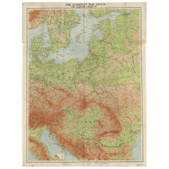
Antique European War Folding Map, ‘circa 1915’
Located in Langweer, NL
Antique folding map of the European War (1914-1915) titled 'The Eastern Campaign '. From Petrograd to Berlin, geographically colored. Published on linen b...
Category
Early 20th Century Maps
Materials
Paper
$717 Sale Price
20% Off
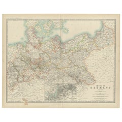
Antique Map of the German Empire by Johnston, '1909'
Located in Langweer, NL
Antique map titled 'Empire of Germany'. Original antique map of the German Empire. With inset maps of Berlin and Potsdam. This map originates from the ‘R...
Category
Early 20th Century Maps
Materials
Paper
$239 Sale Price
20% Off
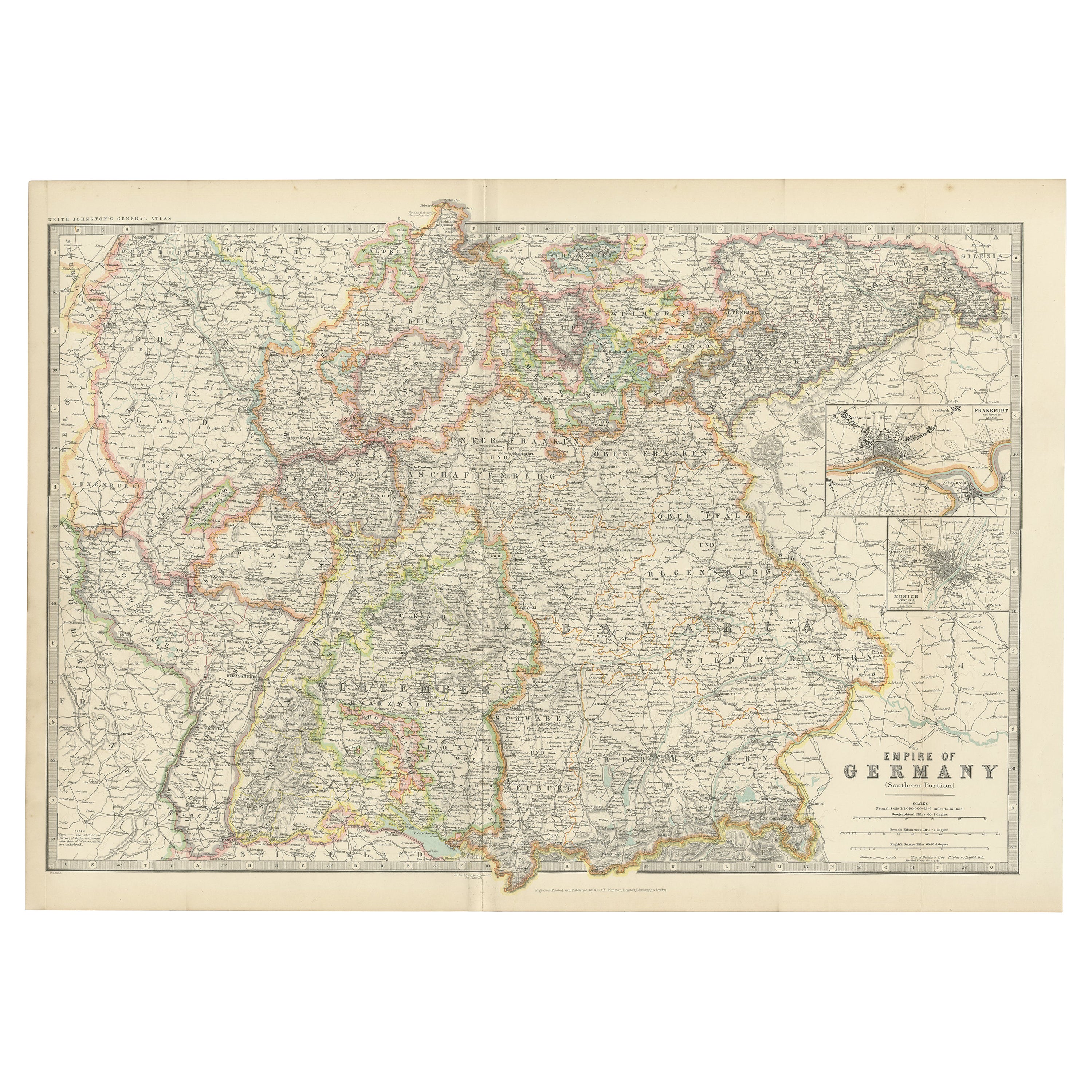
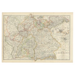
Antique Map of Germany by Johnston '1909'
Located in Langweer, NL
Antique map titled 'Empire of Germany'. Original antique map of Germany. With inset maps of Frankfurt and Munich. This map originates from the ‘...
Category
Early 20th Century Maps
Materials
Paper
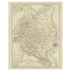
Antique Map of Russia in Europe by Johnston (1909)
Located in Langweer, NL
Antique map titled 'European Russia'. Original antique map of Russia in Europe. With inset maps of St Petersburg and Moscow. This map originates from the ‘Royal Atlas of Modern Geogr...
Category
Early 20th Century Maps
Materials
Paper
$239 Sale Price
20% Off
You May Also Like
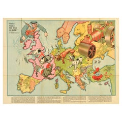
Original Antique World War One Poster Hark The Dogs Do Bark WWI Dogs Of War
Located in London, GB
Original Antique World War One poster - Hark! Hark! The dogs do bark! With note by Walter Emanuel - featuring a serio-comic map of Europe at war with military soldier caricature portraits and some countries represented by dogs with Russia as a bear, a Royal Navy sailor holding leashes on warships crossing to the continent, a British bulldog seen biting German dachshund in a pickelhaube hat, a French poodle in a Phrygian cap, an Austria-Hungarian mongrel being stung by a Serbian wasp, a Swiss mountain climber, a Turk with a French bulldog, a Greek with a knife, a Spanish bullfighter, a Dutchman smiling, an Italian holding a pistol gun with the Russian Tsar...
Category
Vintage 1910s British Posters
Materials
Paper
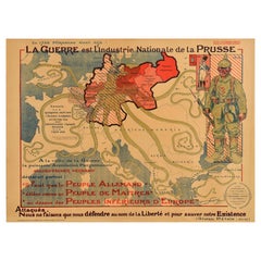
Original Antique Propaganda Poster War National Industry Of Prussia WWI Germany
Located in London, GB
Original antique French propaganda poster featuring a quote by Mirabeau at the top - La Guerre est l'Industrie Nationale de la Prusse / War is the national industry of Prussia - with...
Category
Vintage 1910s French Posters
Materials
Paper
Large Original Vintage Map of North America, circa 1920
Located in St Annes, Lancashire
Great map of North America
Original color. Good condition
Published by Alexander Gross
Unframed.
Category
Vintage 1920s English Edwardian Maps
Materials
Paper

Map of the War between Hungary and Prussia - Etching - 19th Century
Located in Roma, IT
Map of the War between Hungary and Prussia is an etching realized during the 19th century.
Good condition.
Category
Early 19th Century Modern Figurative Prints
Materials
Etching
Map of the War between Hungary and Prussia - Etching - 19th Century
Located in Roma, IT
Map of the War between Hungary and Prussia is an etching realized during the 19th century.
Good condition.
Category
Early 19th Century Modern Figurative Prints
Materials
Etching

1790 Thomas Stackhouse Map, Entitled "Russia in Europe, " , Ric.a004
Located in Norton, MA
1790 Thomas Stackhouse map, entitled
"Russia in Europe"
Ric.a004
Stackhouse, Thomas
Russia in Europe [map]
London: T. Stackhouse, 1783. Map. Matted hand-colored copper engraving. Image size: 14.5 x 15.25 inches. Mat size: 22.75 x 23.75 inches. A beautiful example of this map of Eastern Europe...
Category
Antique 17th Century Unknown Maps
Materials
Paper

More Ways To Browse
British Coins
Song Lyrics
Vintage Scandinavian Armchairs
1970 Italian Armchair
Chrome Glass Coffee Tables
Environment Furniture
China Silk Rug
Early English Silver
Antique Walnut Bar
Ceramic 1960s Italy
Italian Carved Dining Set
Antique Silver Basket
Black Crystal Glasses
Baker Furniture By
Oak Library
T Chair
Antique Italian Chairs
Antique Victorian Dining Tables