Items Similar to 1870 Chart Martha's Vineyard And Nantucket

Want more images or videos?
Request additional images or videos from the seller
1 of 9
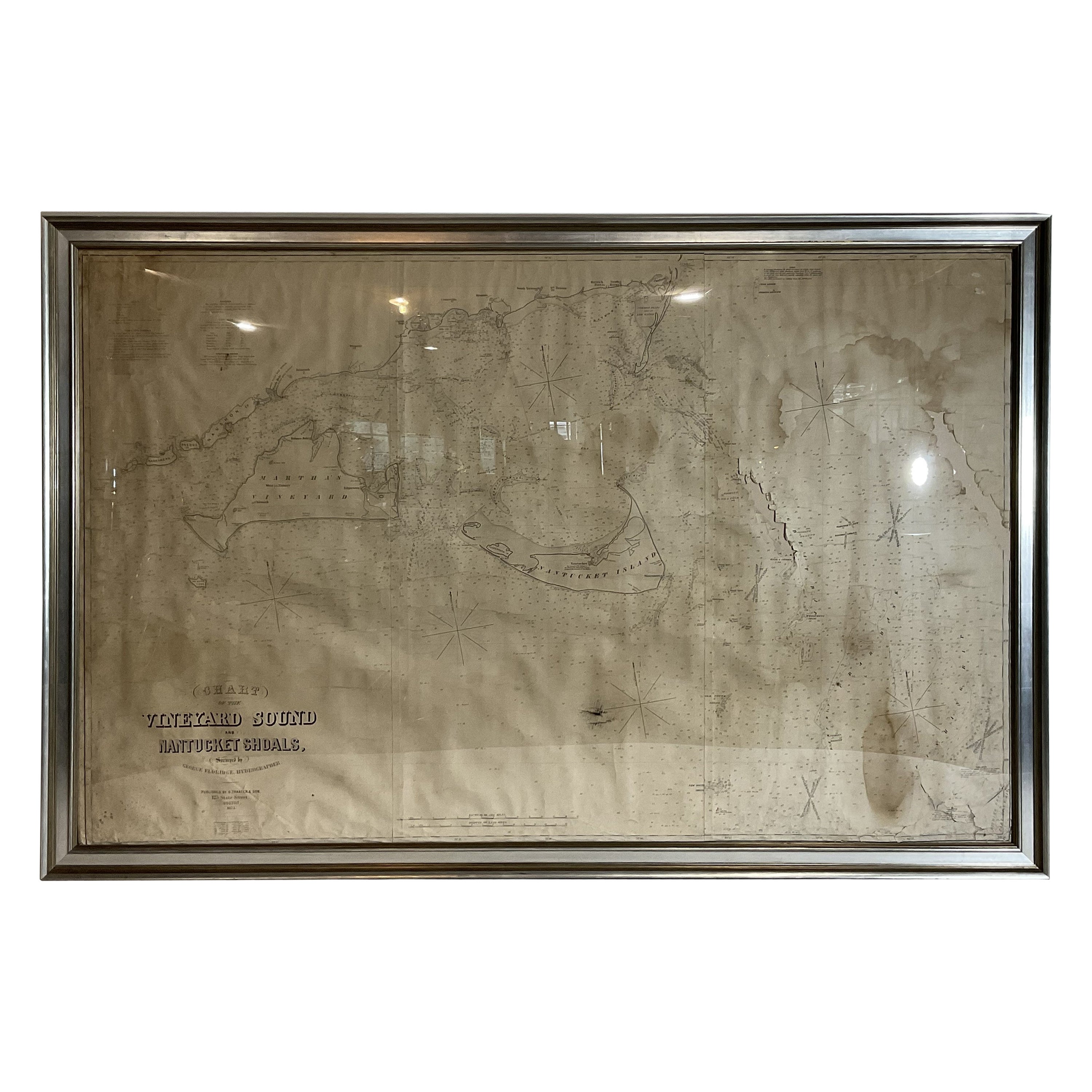
1870 Chart Martha's Vineyard And Nantucket
$2,495
£1,877.43
€2,170.46
CA$3,523.01
A$3,819.98
CHF 2,027.22
MX$47,047.87
NOK 25,126.07
SEK 23,713.23
DKK 16,200.82
About the Item
Nineteenth century 1870 George Eldridge chart titled "Chart Of The Vineyard Sound And Nantucket Shoals", surveyed by George Eldridge hydrographer. Published by S. Thaxter and Son, 125 State St., Boston. Chart shows Nantucket, Tuckernuck, Martha's Vineyard, The Naushon Islands, Woods Hole, Falmouth, Waquoit, Cotuit, Osterville, Harwich, Chatham, etc.. With wrinkles and paper loss at top. Study photos. Dimension; 44"H X 65"L, 14 lbs.
- Dimensions:Height: 44 in (111.76 cm)Width: 65 in (165.1 cm)Depth: 2 in (5.08 cm)
- Materials and Techniques:
- Place of Origin:
- Period:
- Date of Manufacture:1870
- Condition:Refinished.
- Seller Location:Norwell, MA
- Reference Number:Seller: 24AU1861stDibs: LU1741240298112
About the Seller
5.0
Vetted Professional Seller
Every seller passes strict standards for authenticity and reliability
Established in 1967
1stDibs seller since 2015
415 sales on 1stDibs
Typical response time: 1 hour
- ShippingRetrieving quote...Shipping from: Norwell, MA
- Return Policy
Authenticity Guarantee
In the unlikely event there’s an issue with an item’s authenticity, contact us within 1 year for a full refund. DetailsMoney-Back Guarantee
If your item is not as described, is damaged in transit, or does not arrive, contact us within 7 days for a full refund. Details24-Hour Cancellation
You have a 24-hour grace period in which to reconsider your purchase, with no questions asked.Vetted Professional Sellers
Our world-class sellers must adhere to strict standards for service and quality, maintaining the integrity of our listings.Price-Match Guarantee
If you find that a seller listed the same item for a lower price elsewhere, we’ll match it.Trusted Global Delivery
Our best-in-class carrier network provides specialized shipping options worldwide, including custom delivery.More From This Seller
View All1873 Martha's Vineyard and Nantucket Chart
Located in Norwell, MA
Original chart of Nantucket and Martha's Vineyard by George Eldridge, Cartographer, 125 State Street, Boston. Dated 1873. Mounted to canvas. Also showing the coast of Cape Cod includ...
Category
Antique 1870s North American Maps
Materials
Paper

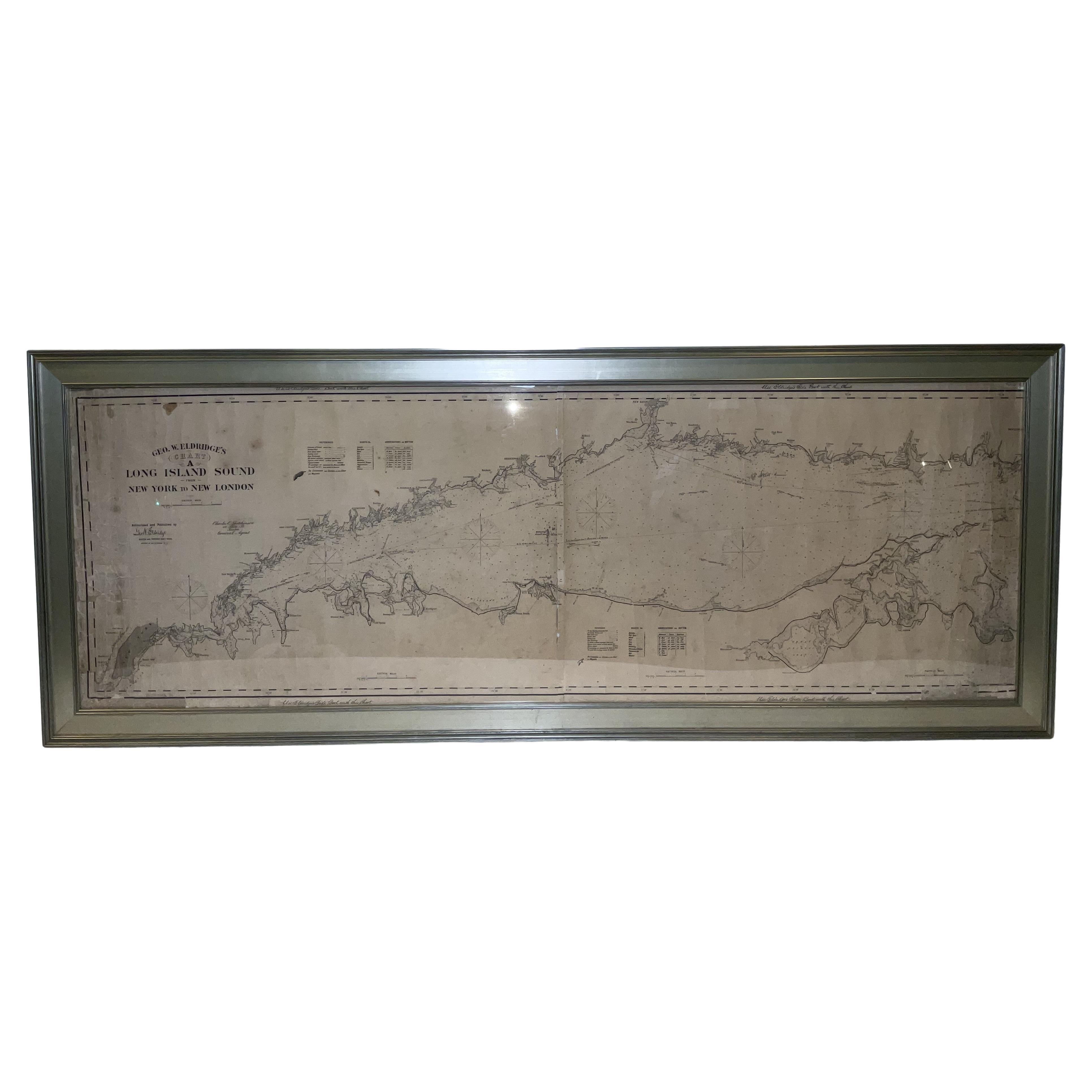
1905 Chart of Long Island Sound by Eldridge
Located in Norwell, MA
Original chart of Long Island Sound by George Eldridge, date-stamped 1905. Also includes the seller's name, Ships Chandler Charles C. Hutchinson, 152 State St., Boston, General Agent...
Category
Antique Early 1900s North American Prints
Materials
Paper
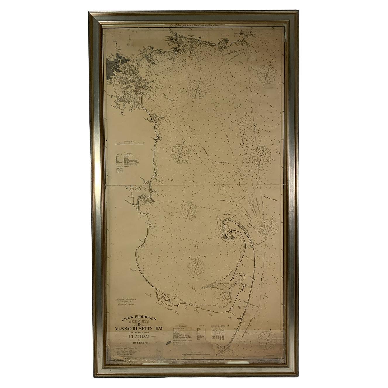
Ocean Chart Of Massachusetts Bay
Located in Norwell, MA
Cape Cod Bay chart from 1907 by George W. Eldridge. This is chart "D" Massachusetts Bay and the coast from Chatham to Boston. Showing plotted courses, depths, lighthouses, ports, etc.. Excellent graphics. Ports include Barnstable, Sandwich, Duxbury, Plymouth, Cohasset, Hingham, Quincy, Boston, Marblehead, Lynn. Manchester by the Sea...
Category
Antique Early 1900s North American Prints
Materials
Paper
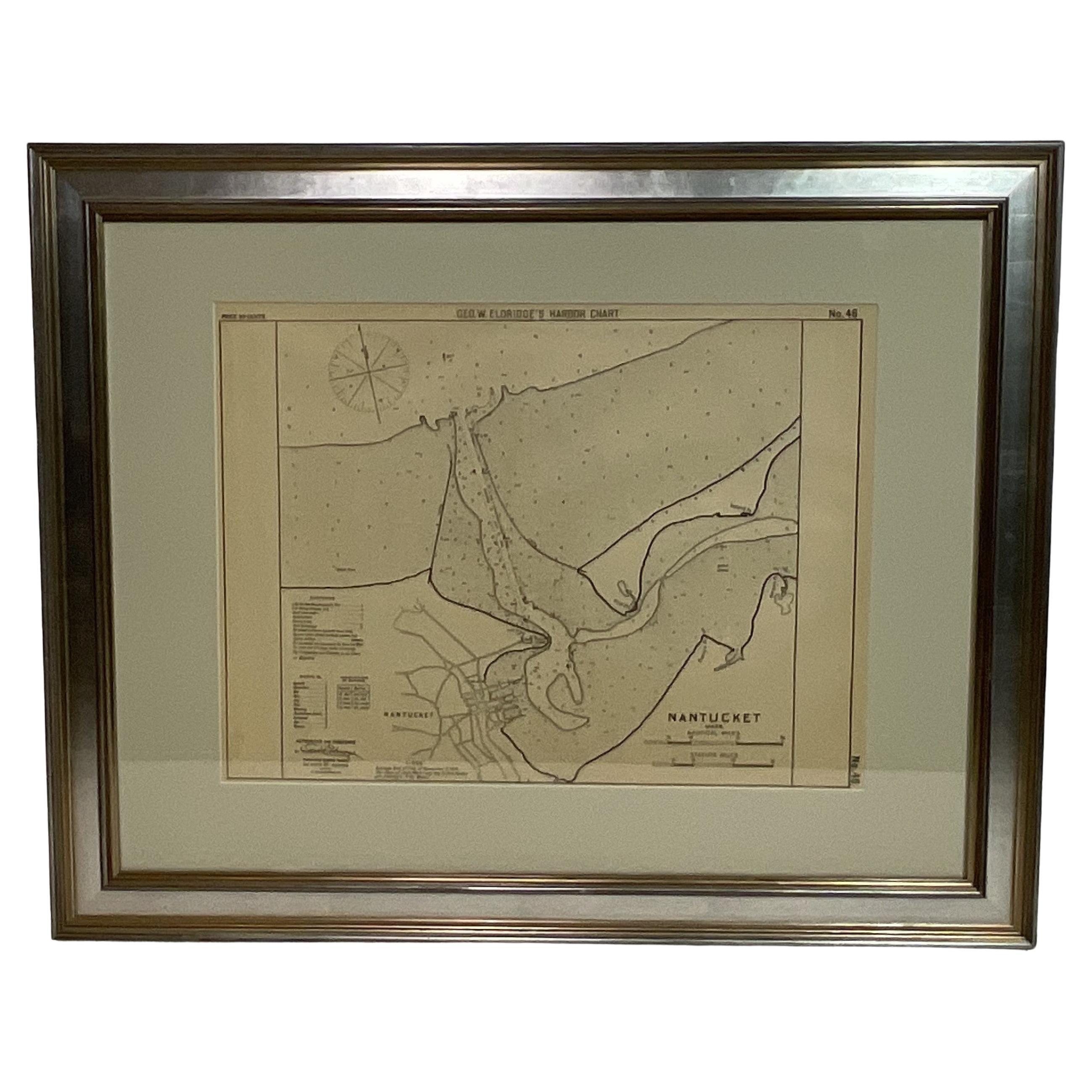
1907 Chart of Nantucket Harbor by George Eldridge
Located in Norwell, MA
Chart of Nantucket Harbor from 1907 by cartographer George W. Eldridge. The chart shows the channel passing by the jetty into the harbor, by Brant Point to Steamboat Wharf. Also show...
Category
Antique Early 1900s North American Maps
Materials
Paper

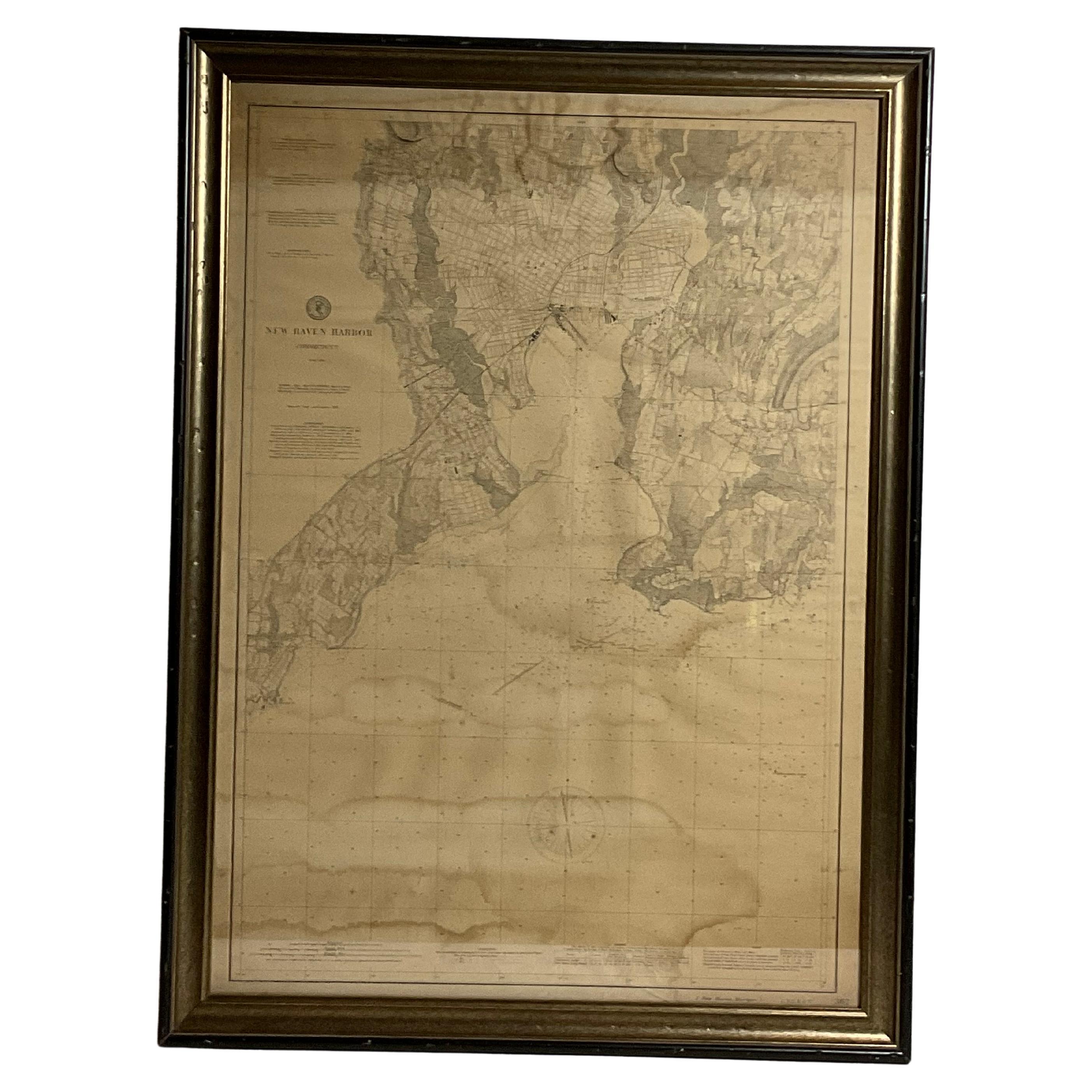
1896 Chart of the New Haven Harbor
Located in Norwell, MA
New Haven Harbor Chart published May 1896 by the United States Coast and geodetic survey. This chart is also a map of the land around the harbor and etc., loaded with detail. Nicely ...
Category
Antique 1890s North American Prints
Materials
Paper

Copy of 1901 Chart of Boston Harbor
Located in Norwell, MA
Later copy after an original Boston Harbor chart by George Eldridge of Vineyard Haven and Boston. Detailed chart of Boston Harbor from the Neponset River in Quincy south down to Kimb...
Category
Vintage 1910s North American Prints
Materials
Paper

You May Also Like
19th Century Chart of New England Coast, 1847
By U.S. Government
Located in Nantucket, MA
19th Century Chart of New England Coast: the U.S. Coast Survey Sketch A - Section 1, a triangulation chart showing the progress of the survey and details along the New England coas...
Category
Antique 1840s American Other Maps
Materials
Paper

Large U.S. Coast and Geodetic Survey Chart A of the Atlantic Coast, 1877
Located in Nantucket, MA
Large U.S. Coast and Geodetic Survey Chart A of the Atlantic Coast, 1877, re-issued in February 1881, a printed paper laid down on linen navigational chart of the U.S. Atlantic coast...
Category
Antique 1880s American Other Maps
Materials
Linen

Framed Mid-19th Century Wall Map of Long Island, the Hamptons
Located in Sag Harbor, NY
A Framed museum quality find. This large wall map dates to the mid-1800s. Detailed inset maps of, Sag Harbor, East Hampton, Amagansett, Shelter Island and most villages in Long Island. It also has agriculture stats for 1855. Detailed prints of homes on Scuttle Hole in Bridgehampton as well as several other detailed prints. Lists of businesses, distance tables and railroad schedules and stops. The total amount of detailed information about Suffolk County Long Island is staggering. A unique rare New York map...
Category
Antique Mid-19th Century American Maps
Materials
Linen, Paper

$7,100 Sale Price
20% Off
Nantucket High-Ways, By-Ways and Not-Ways Decorative Map by Tony Sarg, ca 1930
By Tony Sarg
Located in Nantucket, MA
Vintage Nantucket High-Ways, By-Ways and Not-Ways Decorative Map by Tony Sarg, (Nantucket: 1880 - 1942) circa 1930, a decorative tourist map of Nantucket Island with details of roadw...
Category
Vintage 1930s American Other Maps
Materials
Paper

John Gibson - Map of New England
Located in Savannah, GA
A miniature map of New England from John Gibson’s The Atlas Minimus published in 1758.
John Gibson worked in London from 1748-1773 as a geographer and engraver, producing numerous ...
Category
Antique 1750s British Other Prints
Materials
Glass, Paper
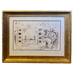
Print of Nantucket Daydreams, by Henry S. Wyer, Nantucket, circa 1900
Located in Nantucket, MA
Antique Print of Nantucket Daydreams, by Henry S. Wyer, Nantucket, circa 1900, a period print depicting a gentleman in overstuffed wing chair by the hearth, a copy of Nantucket's "Inquirer and Mirror" open on lap, smoking a cigar and leaning back lost in thought: in the curls of smoke are simple sketches of many iconic Nantucket landmarks and views. Flanking the fireplace in place of tiles are a series of miniature copies of eight of H.S. Wyer's photographs. This is one of the rarest of antique Nantucket prints...
Category
Antique Early 1900s American Late Victorian Prints
Materials
Paper
More Ways To Browse
Horse Tray
Human Leg
Iittala Glass Birds
Italian Rococo Desk
Jade Dog
Jade Horse
Jade Pot
Japanese Bird Plates
Japanese Bronze Cranes
Japanese Living Treasure
Japanese Maple Art
Japanese Meiji Imari Plates
Japanese Screen Cherry
Japanese Shunga
Japanese Theater Mask
Jesus And Joseph
John Stuart Walnut Dining
John Wanamaker