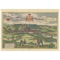
Items Similar to Antique Print of Büdingenin Germany by Braun & Hogenberg, 1617
Want more images or videos?
Request additional images or videos from the seller
1 of 6
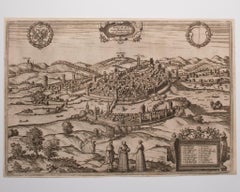
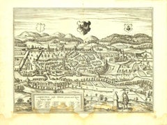
Antique Print of Büdingenin Germany by Braun & Hogenberg, 1617
$277.74
$347.1820% Off
£204.88
£256.1020% Off
€232
€29020% Off
CA$384.83
CA$481.0420% Off
A$417.60
A$52220% Off
CHF 221.29
CHF 276.6120% Off
MX$5,121.64
MX$6,402.0520% Off
NOK 2,738.45
NOK 3,423.0620% Off
SEK 2,587.69
SEK 3,234.6120% Off
DKK 1,766.64
DKK 2,208.2920% Off
About the Item
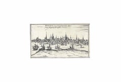
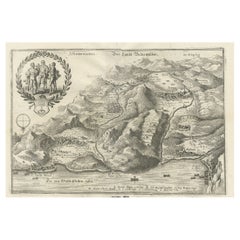
Antique map titled 'Bingen'. Bird's eye-view of Büdingen, Germany. The view shows a city surrounded by vineyards and well fortified with walls and moats. On the right is the castle with its keep. Seen from a high viewpoint in the south, the houses in the city are shown crowded together, with the late Gothic church of St Mary standing out in the middle. The figures in the foreground are a reference to the status of the city: the burgher woman with a hood is shown in accordance with her standing with ruff and full-length skirt, but her apron indicates that she is hard working. The maids, with their skirts tucked up for work and carrying the harvest on their heads, symbolize the fertility of the soil, while the men carrying a prong-hoe and an axe represent the toil in the fields. This print originates from 'Theatri praecipuarum Totius Mundi Urbium'.
Artists and Engravers: Georg Braun (1542-1622), a German publisher and Frans Hogenberg issued the famous six volume town book "Civitates Orbis Terrarum" between 1572 and 1618. The volumes originally published in Latin, follow by German and French translations. Franz Hogenberg (1533-1588) was the son of a Munich engraver who settled in Malines. He engraved most of the plates for Ortelius' Theatrum and the majority of those in the Civitates, and may have been responsible for originating the project. Worked and died in Cologne/Germany. He was a prolific copper engraver and etching artist of maps and town views. In cooperation with Georg Braun he created the first four volumes of the Civitates Orbis Terrarum in 1572.
Condition: Fair, age-related toning and soiling. Few marginal defects. Latin text on verso, please study image carefully.
Date: 1617
Overall size: 53 x 42 cm.
Image size: 48 x 30 cm.
We sell original antique maps to collectors, historians, educators and interior decorators all over the world. Our collection includes a wide range of authentic antique maps from the 16th to the 20th centuries. Buying and collecting antique maps is a tradition that goes back hundreds of years. Antique maps have proved a richly rewarding investment over the past decade, thanks to a growing appreciation of their unique historical appeal. Today the decorative qualities of antique maps are widely recognized by interior designers who appreciate their beauty and design flexibility. Depending on the individual map, presentation, and context, a rare or antique map can be modern, traditional, abstract, figurative, serious or whimsical.
- Dimensions:Height: 16.54 in (42 cm)Width: 20.87 in (53 cm)Depth: 0 in (0.01 mm)
- Materials and Techniques:
- Period:
- Date of Manufacture:1617
- Condition:Condition: Fair, age-related toning and soiling. Few marginal defects. Latin text on verso, please study image carefully.
- Seller Location:Langweer, NL
- Reference Number:Seller: BG-121301stDibs: LU3054329355402
About the Seller
5.0
Recognized Seller
These prestigious sellers are industry leaders and represent the highest echelon for item quality and design.
Platinum Seller
Premium sellers with a 4.7+ rating and 24-hour response times
Established in 2009
1stDibs seller since 2017
2,622 sales on 1stDibs
Typical response time: <1 hour
- ShippingRetrieving quote...Shipping from: Langweer, Netherlands
- Return Policy
Authenticity Guarantee
In the unlikely event there’s an issue with an item’s authenticity, contact us within 1 year for a full refund. DetailsMoney-Back Guarantee
If your item is not as described, is damaged in transit, or does not arrive, contact us within 7 days for a full refund. Details24-Hour Cancellation
You have a 24-hour grace period in which to reconsider your purchase, with no questions asked.Vetted Professional Sellers
Our world-class sellers must adhere to strict standards for service and quality, maintaining the integrity of our listings.Price-Match Guarantee
If you find that a seller listed the same item for a lower price elsewhere, we’ll match it.Trusted Global Delivery
Our best-in-class carrier network provides specialized shipping options worldwide, including custom delivery.More From This Seller
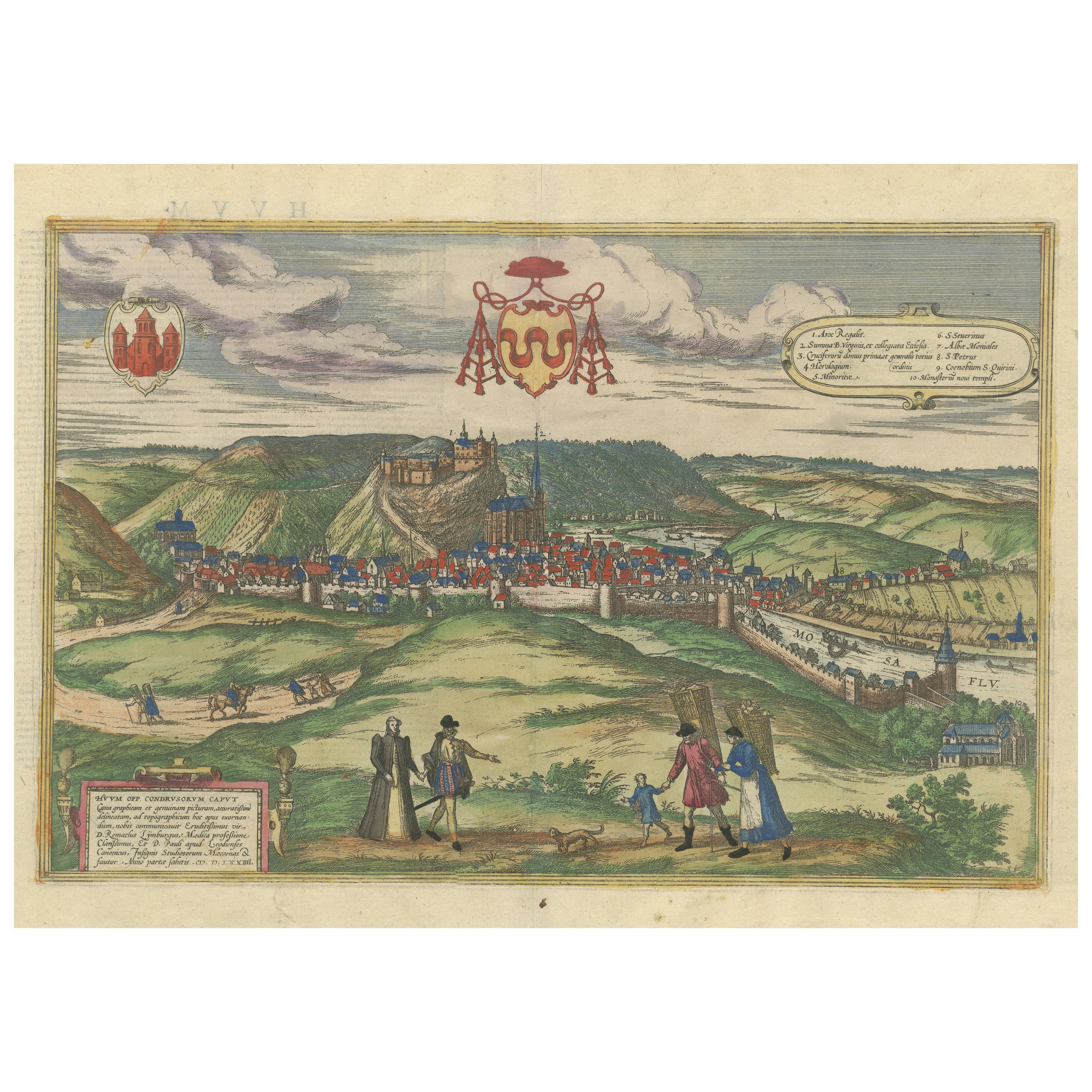
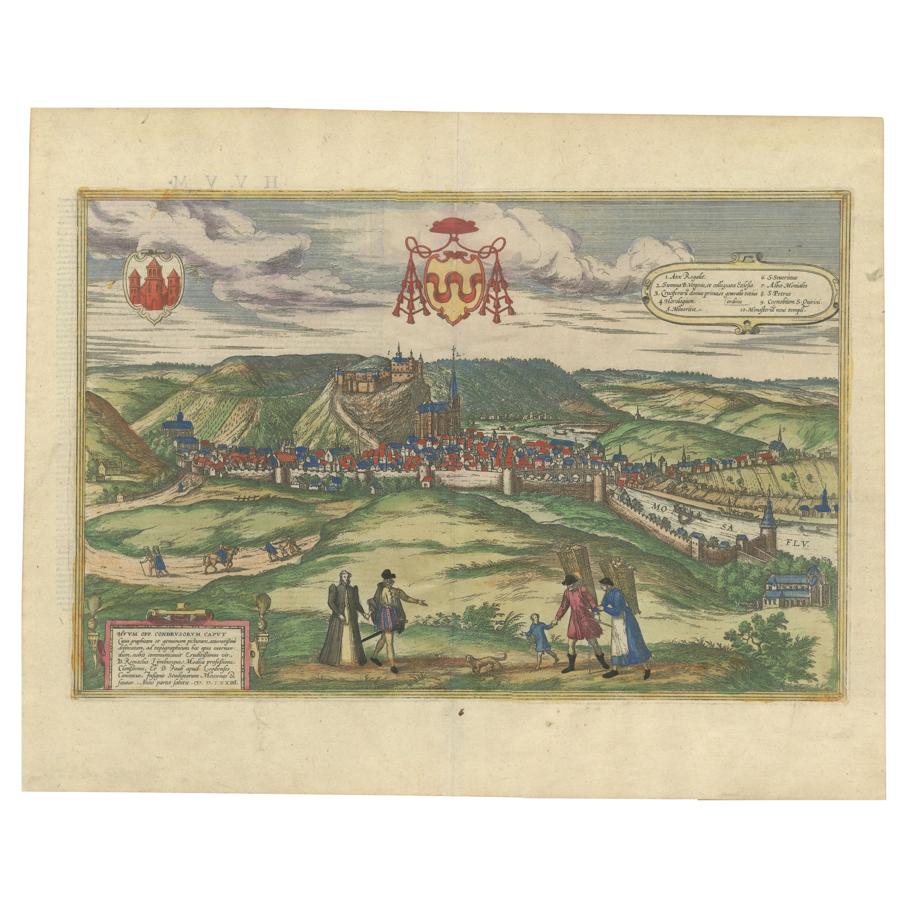
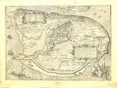
View AllOriginal Antique Print of Huy in present day Belgium, Published circa 1580
Located in Langweer, NL
Antique print titled 'Huum Opp. Condrusorum Caput (..)'. Attractive bird’s eye view of Huy in present day Belgium. The view shows the city from the northeast. Huy, a municipality of ...
Category
Antique 16th Century Prints
Materials
Paper
$842 Sale Price
20% Off
Free Shipping
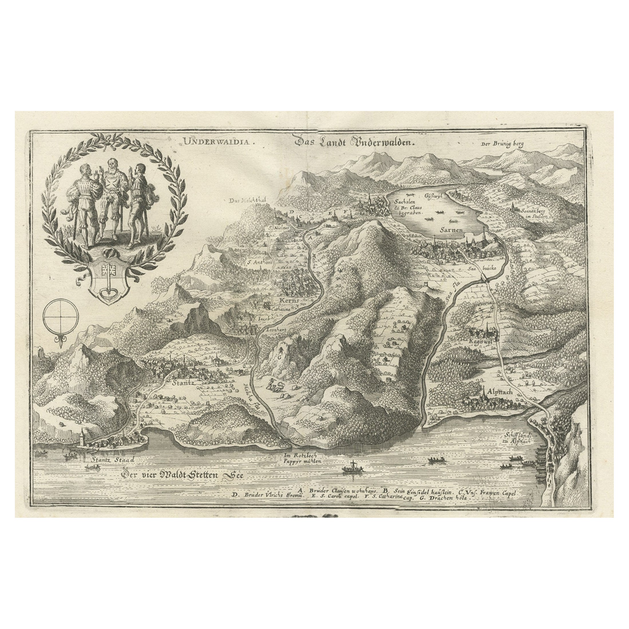
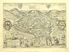
Antique Print of Unterwalden, South of Lake Lucerne in Switzerland, 1654
Located in Langweer, NL
Antique print titled 'Underwaldia - Das Landt Underwalden'. View of the city of Unterwalden, the old name of a forest-canton of the Old Swiss Confederacy in central Switzerland, south of Lake Lucerne...
Category
Antique 17th Century Prints
Materials
Paper
$488 Sale Price
20% Off
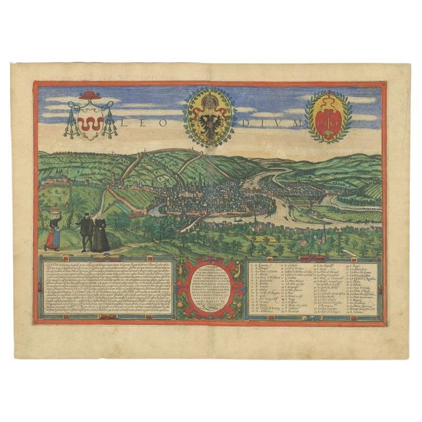
Antique Print of Liège / Luik in Belgium by Braun & Hogenberg, 1575
Located in Langweer, NL
Antique print titled 'Leodium'. View of Liège / Luik, Belgium with surrounding hills and the city wall. With text explaining the origins of Liège, a cartouche expressing thanks to th...
Category
Antique 16th Century Prints
Materials
Paper
$1,283 Sale Price
20% Off
Huy (Huum) Cityscape 1574: Historical Copper Engraving by Braun & Hogenberg
Located in Langweer, NL
Title: Huum opp. condrusorum caput (...) Anno partae salutis 1574.
**Type:** Print (Colored Copper Engraving)
**Year:** Circa 1580
**Technique:** Colored Copper Engraving
**Medium:...
Category
Antique 16th Century Maps
Materials
Paper
$612 Sale Price
20% Off
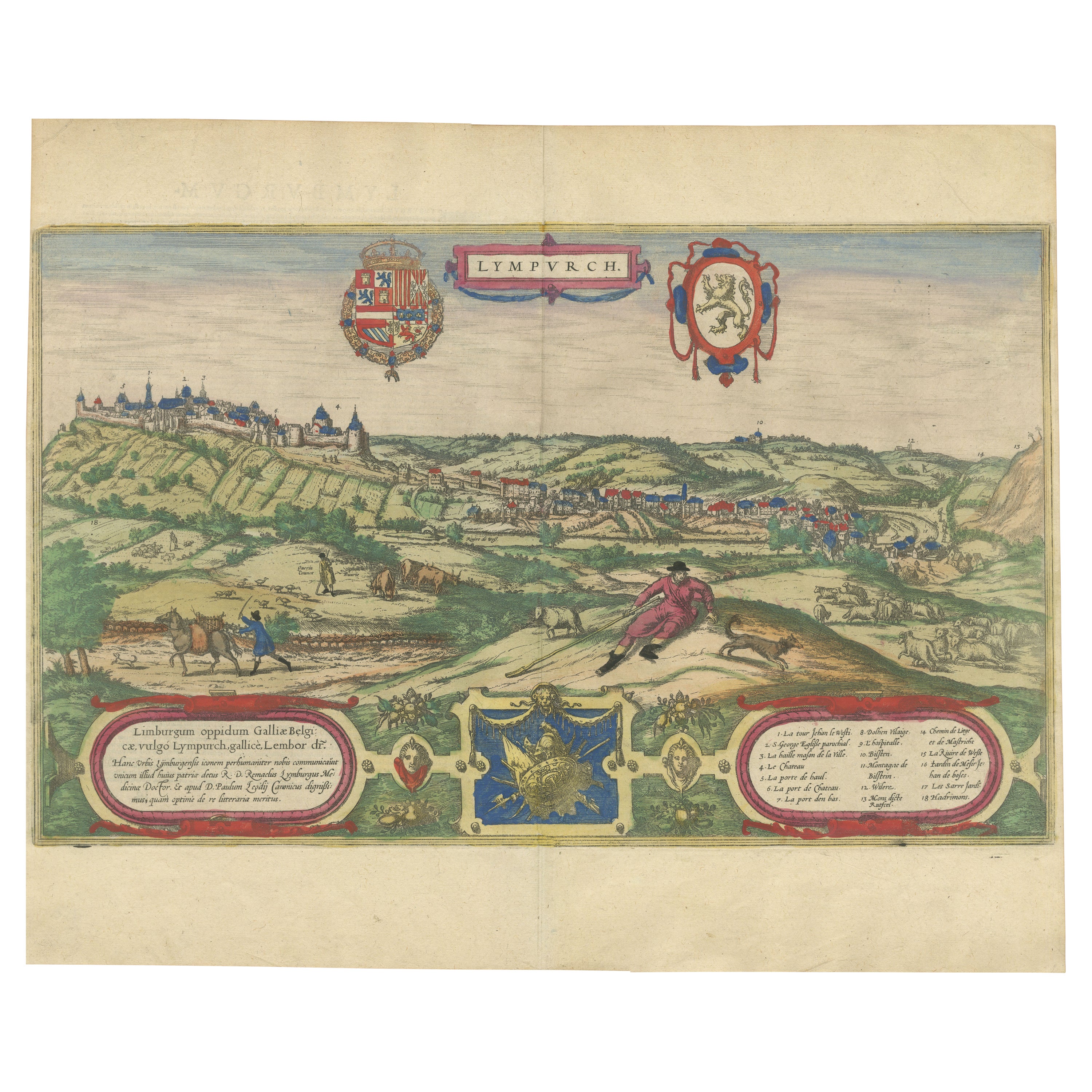
Limburg Cityscape 1580: Historical Copper Engraving by Braun and Hogenberg
Located in Langweer, NL
Title: Limburgum Oppidum Galliae Belgicae, vulgo Lympurch, gallicè, Lembor Dr.
Type: Print (Copper Engraving)
Circa 1580
Technique: Colored Copper Engraving
Medium: Handmade Paper
S...
Category
Antique 16th Century German Maps
Materials
Paper

Antique Print of Hanseatic City of Lübeck in Northern Germany by Merian, c.1650
Located in Langweer, NL
Antique print titled 'Lubecca, Lübeck'. A bird's eye view of Lubeck, the northern German city in Schleswig-Holstein. This print originates from 'Topographia Saxoniae Inferioris'.
Ar...
Category
Antique 17th Century Prints
Materials
Paper
$373 Sale Price
20% Off
You May Also Like
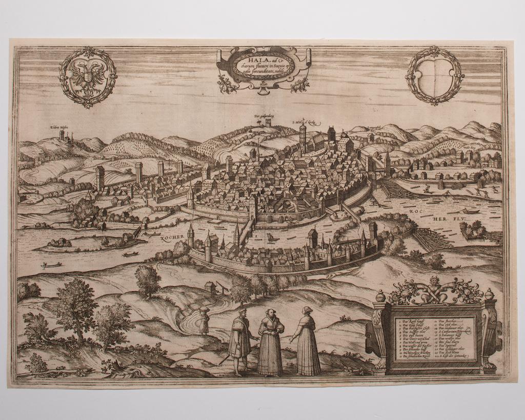
Schwäbisch Hall - Etching by G. Braun e F. Hogenberg- Late 16th Century
Located in Roma, IT
This Schwäbisch Hall is an original etching realized by George Braun and Frans Hogenberg, part of the famous series “Civitates Orbis Terrarum”"
The state of preservation of the art...
Category
16th Century Figurative Prints
Materials
Etching
Brielle Den Briel - Etching by G. Braun and F. Hogenberg - Late 16th Century
By Franz Hogenberg
Located in Roma, IT
This View of Brilium is an original etching realized by George Braun and Franz Hogenberg as part of the famous series "Civitates Orbis Terrarum".
The “Civitates Orbis Terrarum” (At...
Category
16th Century Figurative Prints
Materials
Etching
Ancient View of Oxonium - Etching by G. Braun and F. Hogenberg - 17th Century
By Franz Hogenberg
Located in Roma, IT
Ancient view of Oxonium (Oxford) is an old master artwork realized by George Braun and Franz Hogenberg in the early 17th Century, as part of the famous Series "Civitates Orbis Terrar...
Category
17th Century Old Masters Figurative Prints
Materials
Etching
View of Vesontio - Etching by G. Braun and F. Hogenberg - Late 16th Century
By Franz Hogenberg
Located in Roma, IT
This View of Vesontio is an original etching realized by George Braun and Franz Hogenberg, as part of the famous Series "Civitates Orbis Terrarum".
The “Civitates Orbis Terrarum” (A...
Category
16th Century Figurative Prints
Materials
Etching
View of Kempten in Allgau - Etching by G. Braun and F. Hogenberg - Late 1500
By Franz Hogenberg
Located in Roma, IT
This View of Kempten in Allgau, the Ancient Campidonia, is an original etching realized by George Braun and Franz Hogenberg as part of the famous series "Civitates Orbis Terrarum".
...
Category
16th Century Figurative Prints
Materials
Etching
City of Wismaria - Original Etching by F. Hogenberg - 16th Century
By Franz Hogenberg
Located in Roma, IT
Portrait of the City of Wismaria is an original etching realized by Georg Braun and Franz Hogenberg as part of the suite "Civitates Orbis Terrarum".
Precious etching, showing a view...
Category
16th Century Figurative Prints
Materials
Etching