Items Similar to Antique Title Page of Géographie Universelle Atlas-Migeon, 1880


Want more images or videos?
Request additional images or videos from the seller
1 of 6
Antique Title Page of Géographie Universelle Atlas-Migeon, 1880
$76.19
$95.2420% Off
£56.63
£70.7920% Off
€64
€8020% Off
CA$105.20
CA$131.5020% Off
A$116.66
A$145.8220% Off
CHF 61.29
CHF 76.6220% Off
MX$1,425.36
MX$1,781.6920% Off
NOK 766.88
NOK 958.6020% Off
SEK 719.85
SEK 899.8120% Off
DKK 487.33
DKK 609.1620% Off
About the Item
Antique frontispiece titled 'Géographie Universelle'. Original title page of 'Géographie Universelle Atlas-Migeon' by J. Migeon.
Artists and Engravers: Published by J. Migeon. Reviewed by A. Vuillemin. Alexandre Vuillemin (1812-1880) was a cartographer and an book editor based in Paris, France.
Condition: Good, age-related toning. Please study image carefully.
Date: 1880
Overall size: 47.5 x 34.5 cm.
Image size: 40 x 27.5 cm.
Antique prints have long been appreciated for both their aesthetic and investment value. They were the product of engraved, etched or lithographed plates. These plates were handmade out of wood or metal, which required an incredible level of skill, patience and craftsmanship. Whether you have a house with Victorian furniture or more contemporary decor an old engraving can enhance your living space.
- Dimensions:Height: 13.78 in (35 cm)Width: 18.9 in (48 cm)Depth: 0 in (0.01 mm)
- Materials and Techniques:
- Period:
- Date of Manufacture:1880
- Condition:Condition: Good, age-related toning. Please study image carefully.
- Seller Location:Langweer, NL
- Reference Number:Seller: BG-11793-11stDibs: LU3054329868992
About the Seller
5.0
Recognized Seller
These prestigious sellers are industry leaders and represent the highest echelon for item quality and design.
Platinum Seller
Premium sellers with a 4.7+ rating and 24-hour response times
Established in 2009
1stDibs seller since 2017
2,609 sales on 1stDibs
Typical response time: <1 hour
- ShippingRetrieving quote...Shipping from: Langweer, Netherlands
- Return Policy
Authenticity Guarantee
In the unlikely event there’s an issue with an item’s authenticity, contact us within 1 year for a full refund. DetailsMoney-Back Guarantee
If your item is not as described, is damaged in transit, or does not arrive, contact us within 7 days for a full refund. Details24-Hour Cancellation
You have a 24-hour grace period in which to reconsider your purchase, with no questions asked.Vetted Professional Sellers
Our world-class sellers must adhere to strict standards for service and quality, maintaining the integrity of our listings.Price-Match Guarantee
If you find that a seller listed the same item for a lower price elsewhere, we’ll match it.Trusted Global Delivery
Our best-in-class carrier network provides specialized shipping options worldwide, including custom delivery.More From This Seller
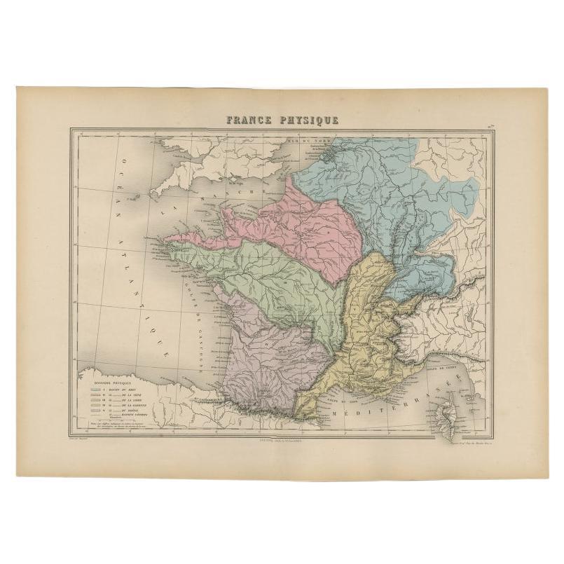
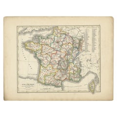
View AllAntique Map of France by Migeon, 1880
Located in Langweer, NL
Antique map titled 'France Physique'. Old map of France. This map originates from 'Géographie Universelle Atlas-Migeon' by J. Migeon.
Artists and Engravers: Published by J. Migeon...
Category
Antique 19th Century Maps
Materials
Paper

$123 Sale Price
20% Off
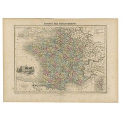
Antique Map of the Departments of France by Migeon, 1880
By J. Migeon
Located in Langweer, NL
Antique map titled 'France par Départements'. Old map of France with a decorative vignette of Strasbourg and an inset map of Corsica. This map originate...
Category
Antique 19th Century Maps
Materials
Paper
$114 Sale Price
20% Off
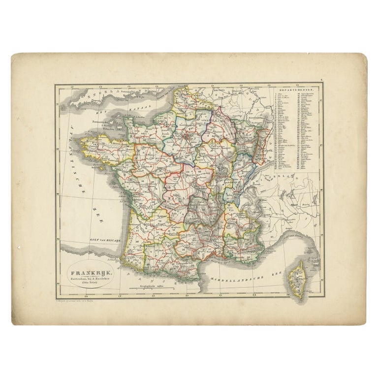
Antique Map of France from an Old Dutch School Atlas, 1852
Located in Langweer, NL
Antique map titled 'Frankrijk'. Map of France. This map originates from 'School-Atlas van alle deelen der Aarde' by Otto Petri. Artists and Engravers: Published by A. Baedeker (Otto ...
Category
Antique 19th Century Maps
Materials
Paper
$114 Sale Price
20% Off
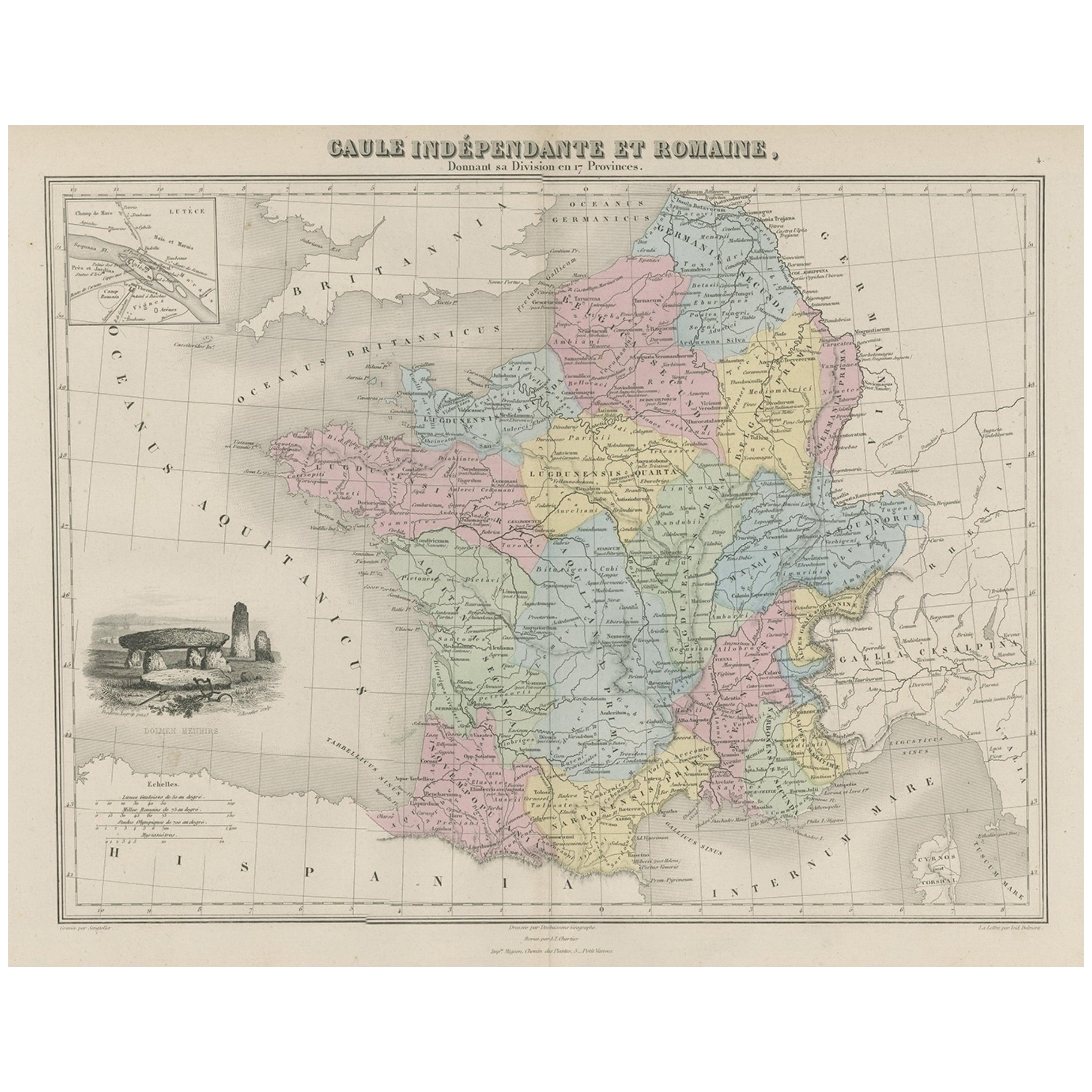
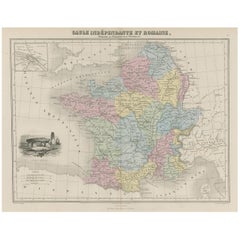
Antique Map of France in Ancient Roman Times, 1880
Located in Langweer, NL
Antique map titled 'Gaule indépendante et Romaine'.
Old map of Gaul or France in ancient Roman times. The map covers from the southern part of England (Britannia) to the north of S...
Category
Antique 19th Century Maps
Materials
Paper
$180 Sale Price
20% Off
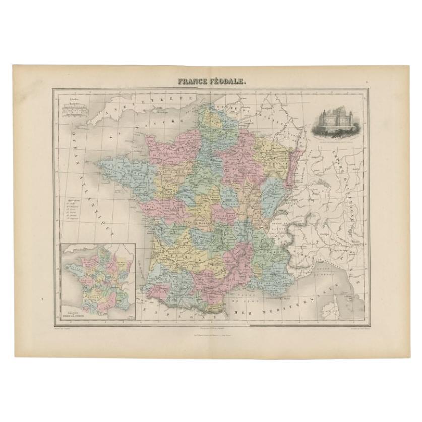
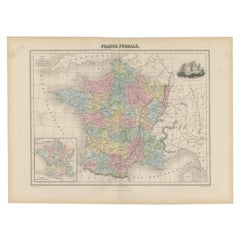
Antique Political Map of France, 1880
By J. Migeon
Located in Langweer, NL
Antique map titled 'France Féodale'. Old map of France with a decorative vignette of Castle de Pierrefonds. This map originates from 'Géographie Universelle Atlas-Migeon' by J. Migeo...
Category
Antique 19th Century Maps
Materials
Paper
$114 Sale Price
20% Off
Antique Map of France by A & C. Black, 1870
Located in Langweer, NL
Antique map titled 'France'. Original antique map of France with inset map of France as divided into provinces, before the revolution of 1789 and map of Corsica...
Category
Antique Late 19th Century Maps
Materials
Paper

$261 Sale Price
20% Off
You May Also Like
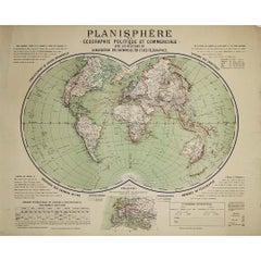
Circa 1900 original poster Planisphère de géographie politique et commercial
Located in PARIS, FR
This circa 1900 original poster, "Planisphère de Géographie Politique et Commerciale," is a fascinating artifact of early 20th-century cartography, created by H. Bouthillier de Beaum...
Category
Early 1900s Prints and Multiples
Materials
Lithograph, Paper
Ancient National Atlas of France with Marengo
Located in Alessandria, Piemonte
Ancient National Atlas of France with the department of Marengo: a rare French etching dated 1806.
ST/178.
Category
Antique Early 19th Century French Other Prints
Materials
Paper

1864 Original illustrated planisphere - World Map - Geography
Located in PARIS, FR
Immerse yourself in the epic journey of the past with the Illustrated Historical Planisphere of 1864 by Charpentier! 🗺️ This cartographic treasure transports you through the intrica...
Category
1860s Prints and Multiples
Materials
Linen, Lithograph, Paper

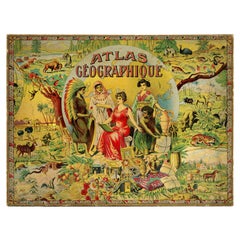
Exceptional Atlas Puzzle by Léon Saussine, ca.1900
Located in Saint-Amans-des-Cots, FR
French atlas puzzle edited by Léon Saussine, France, ca.1900. Exceptional puzzle composed of 7 boards entitled Mappemonde (world map), France par départements (France by departments)...
Category
Antique Early 1900s Art Nouveau Games
Materials
Paper
1860 Large Map "Carte De La Siberie Russie D'asie, " Ric.R0001
Located in Norton, MA
Large 1860 map "Carte De La Siberie Russie D'Asie," R-0001
" Authentic" - 1860 map "Carte De La Siberie Russie D'Asie,"
Dimension: Paper: 68 cm W x 51 cm H ; Sight: 51cm W x 4...
Category
Antique 19th Century Unknown Maps
Materials
Paper

1714 Henri Chatelain "Nouvelle Carte Des Etatas Du Grand.Duc De Mos Moscovie Eur
Located in Norton, MA
A 1714 Henri Chatelain map, entitled
"Nouvelle Carte Des Etatas Du Grand Duc De Moscovie En Europe,"
Ricb001
Henri Abraham Chatelain (1684-1743) was a Huguenot pastor of Parisi...
Category
Antique Early 18th Century Dutch Maps
Materials
Paper

More Ways To Browse
Asian Cork Art
Asymmetrical Bed
Aubergine Porcelain
Baccarat Limited Edition
Baroque Bureau
Beds French Style Mahogany
Biscuit Bowl
Black Curio Cabinet
Black Tansu
Bleu Turquin Marble
Bleu Turquin
Blue Cat Ceramic
Boat Shaped Bowl
Bone China Tea Set
Brass Bed Finials
British Throne
Brunschwig And Fils Fabric
Bureau Art Nouveau