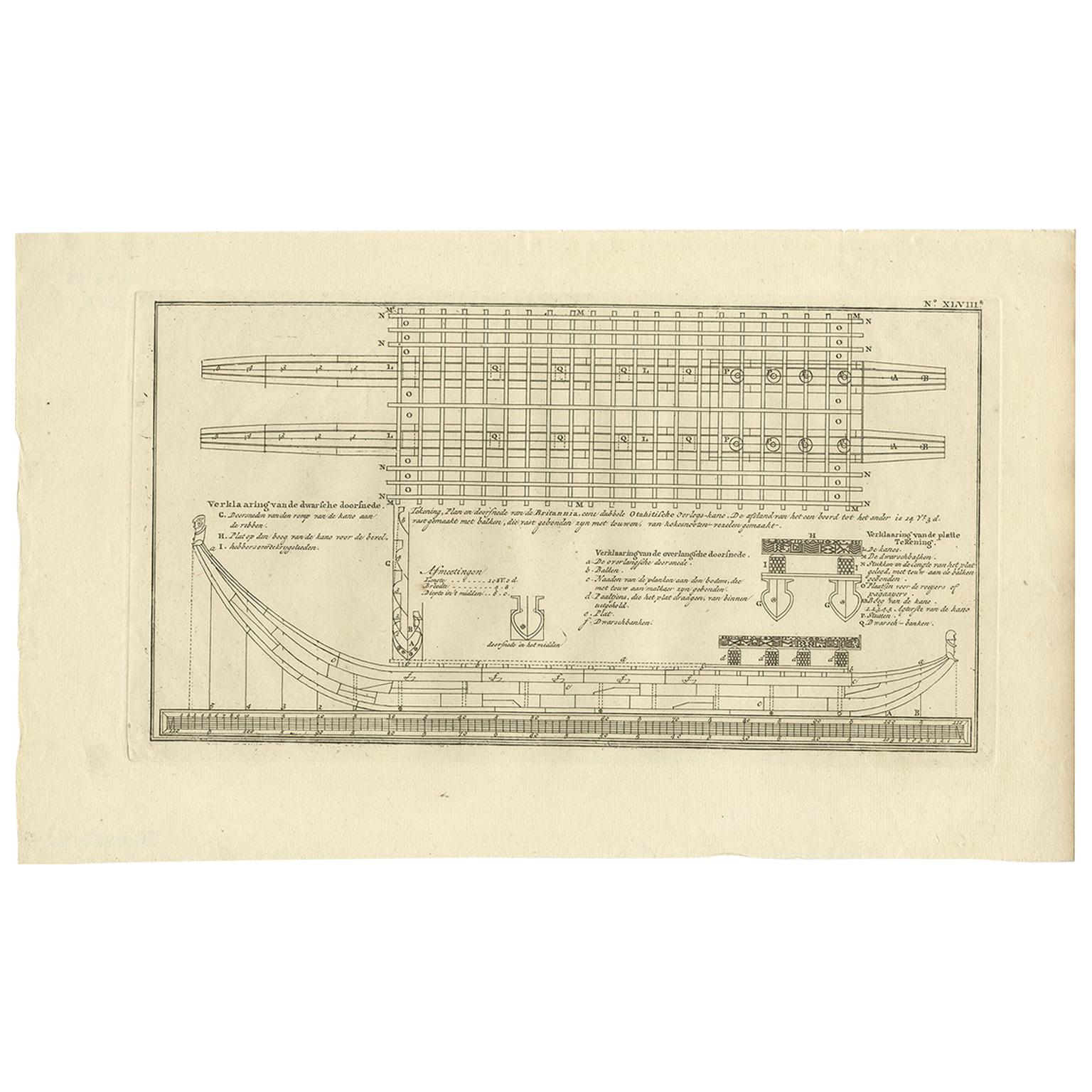
Items Similar to Old Drawing or Plan of a Proa of Amsterdam Island, Now Tongatapu, Tonga, 1803

Want more images or videos?
Request additional images or videos from the seller
1 of 5
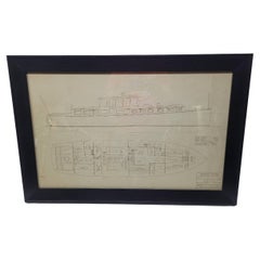
Old Drawing or Plan of a Proa of Amsterdam Island, Now Tongatapu, Tonga, 1803
$420.67
$525.8420% Off
£311.42
£389.2820% Off
€352
€44020% Off
CA$582.10
CA$727.6320% Off
A$641.66
A$802.0720% Off
CHF 335.74
CHF 419.6820% Off
MX$7,872.91
MX$9,841.1420% Off
NOK 4,226.36
NOK 5,282.9520% Off
SEK 3,952.31
SEK 4,940.3920% Off
DKK 2,680.13
DKK 3,350.1620% Off
About the Item
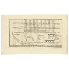
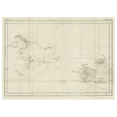
Antique print titled 'Tekening, Plan en Doorsnede van eene dubbele Praauw (..)'.
Antique print depicting a drawing, plan and cross-section of a proa of Amsterdam Island. Amsterdam Island was discovered by Abel Tasman in 1643 and named as such because of it's abundance of supplies. It is now named Tongatapu, the main island of the Kingdom of Tonga. Originates from 'Reizen Rondom de Waereld door James Cook (..)'.
Artists and engravers: Translated by J.D. Pasteur. Published by Honkoop, Allart en Van Cleef.
- Dimensions:Height: 10.24 in (26 cm)Width: 16.54 in (42 cm)Depth: 0 in (0.02 mm)
- Materials and Techniques:
- Period:
- Date of Manufacture:1803
- Condition:Condition: Very good, general age-related toning. Please study image carefully.
- Seller Location:Langweer, NL
- Reference Number:Seller: BG-11487-114 1stDibs: LU3054326929982
About the Seller
5.0
Recognized Seller
These prestigious sellers are industry leaders and represent the highest echelon for item quality and design.
Platinum Seller
Premium sellers with a 4.7+ rating and 24-hour response times
Established in 2009
1stDibs seller since 2017
2,613 sales on 1stDibs
Typical response time: <1 hour
- ShippingRetrieving quote...Shipping from: Langweer, Netherlands
- Return Policy
Authenticity Guarantee
In the unlikely event there’s an issue with an item’s authenticity, contact us within 1 year for a full refund. DetailsMoney-Back Guarantee
If your item is not as described, is damaged in transit, or does not arrive, contact us within 7 days for a full refund. Details24-Hour Cancellation
You have a 24-hour grace period in which to reconsider your purchase, with no questions asked.Vetted Professional Sellers
Our world-class sellers must adhere to strict standards for service and quality, maintaining the integrity of our listings.Price-Match Guarantee
If you find that a seller listed the same item for a lower price elsewhere, we’ll match it.Trusted Global Delivery
Our best-in-class carrier network provides specialized shipping options worldwide, including custom delivery.More From This Seller
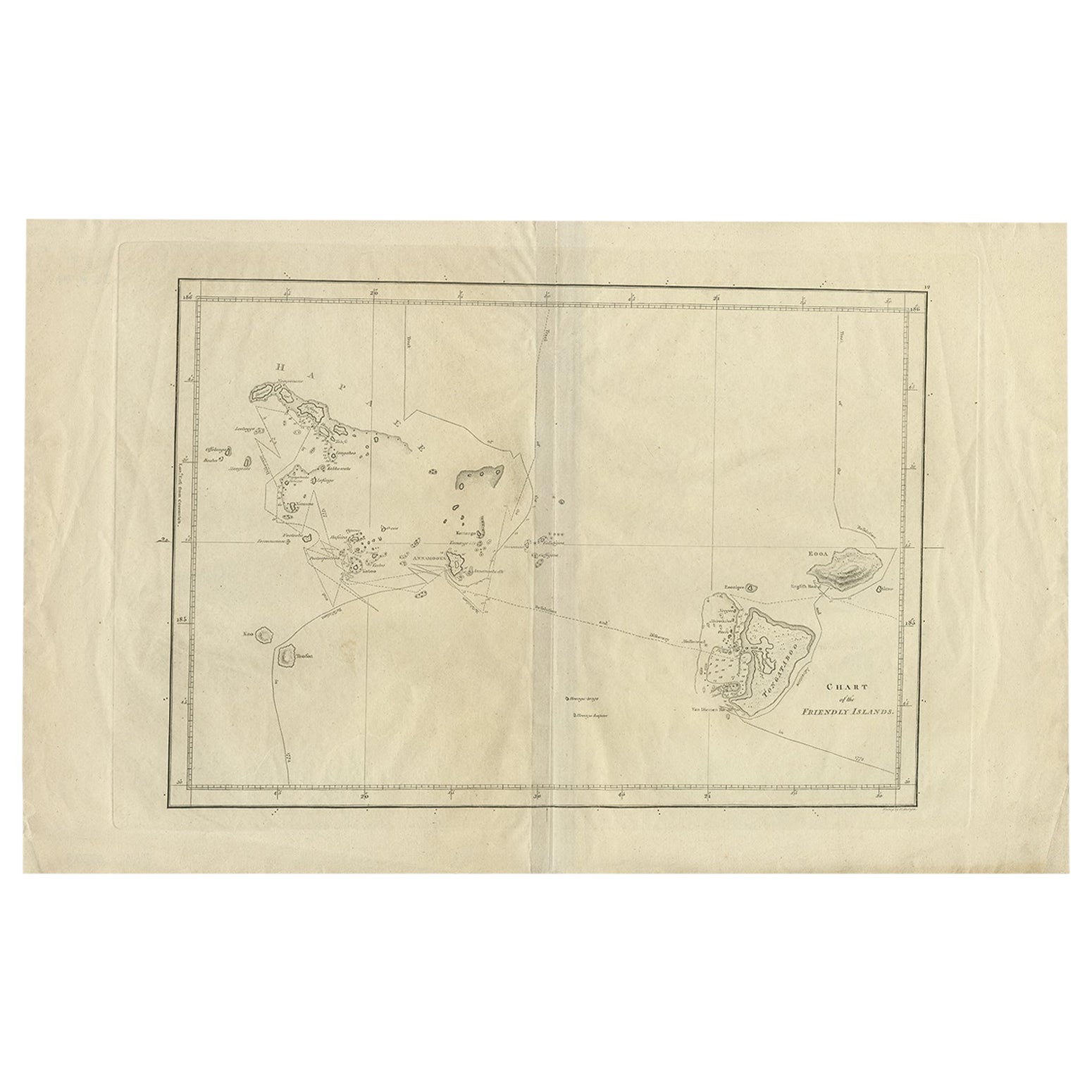
View AllAntique Chart of the Friendly Islands or Tonga in the Pacific Ocean, 1785
By James Cook
Located in Langweer, NL
Antique print titled 'Chart of the Friendly Islands'. Antique map of the Friendly Islands depicting Rotterdam or Anamocka, Middelburg or Eaoowe and Amsterdam or Tongatabu. Originates...
Category
Antique 18th Century Prints
Materials
Paper
$181 Sale Price
20% Off
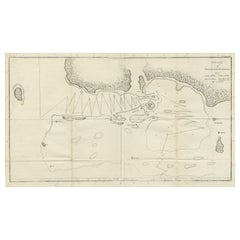
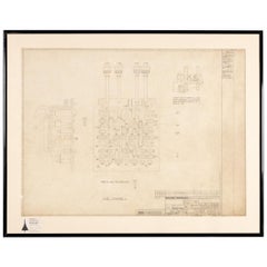
Antique Plan of Britannia 'Cross Section' by Cook, 1803
Located in Langweer, NL
Antique print titled 'Tekening, Plan en Doorsnede van de Britannia (..)'. This print depicts the the Tahiti war Canoe, double connected with beams and bonded with coconut ropes. Orig...
Category
Antique Early 19th Century Dutch Prints
Materials
Paper
$267 Sale Price
20% Off
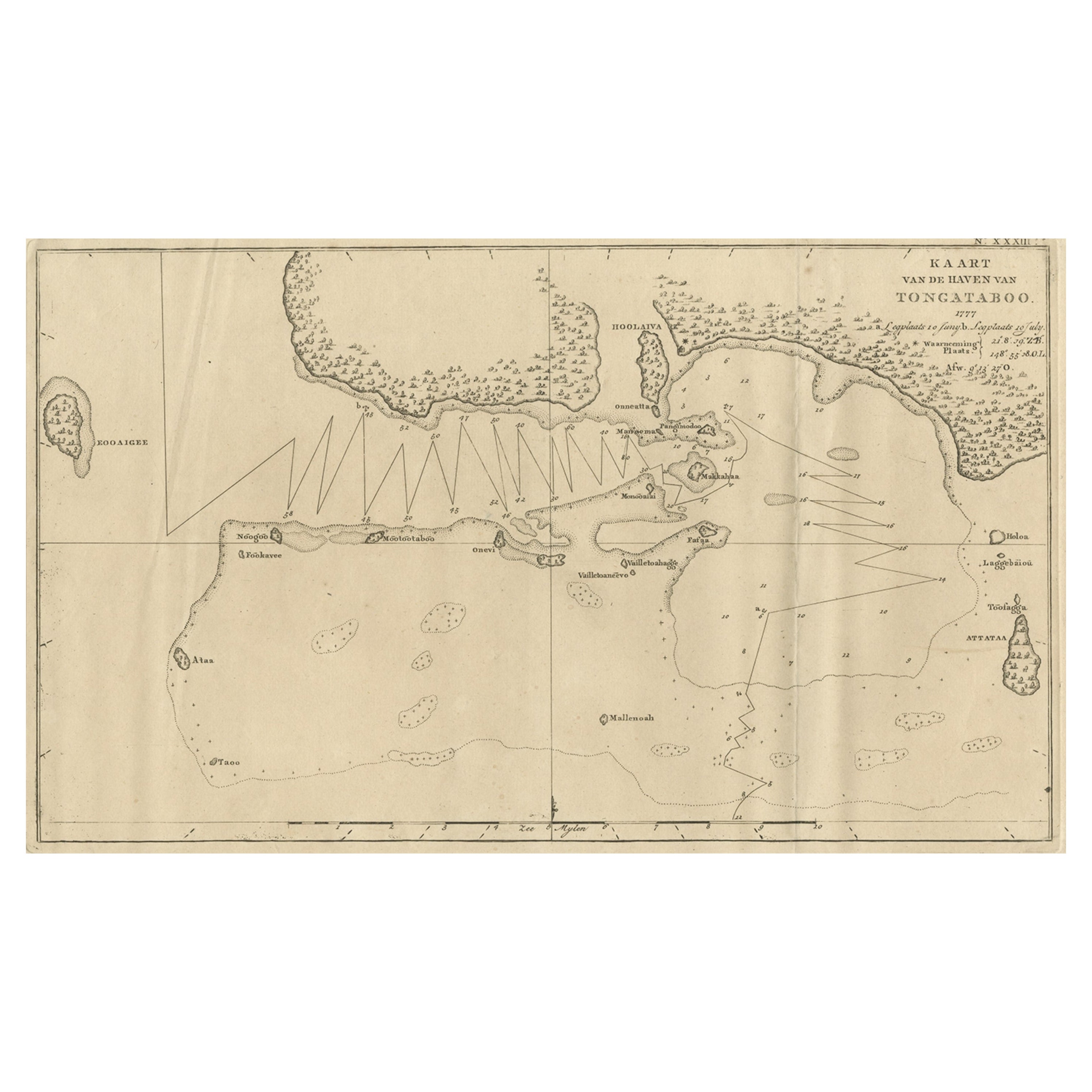
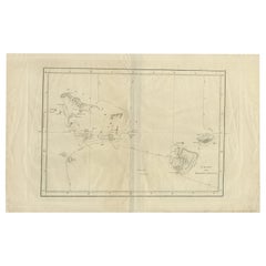
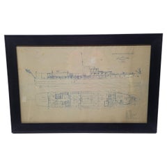
Antique Map of the Harbour of Tongatabu, One of the Tonga Islands, 1803
Located in Langweer, NL
Antique map Tonga titled 'Kaart van de Haven van Tongataboo'.
Antique map of the harbour of Tongatabu, one of the Tonga Islands. Originates from 'Reizen Rondom de Waereld door Ja...
Category
Antique Early 1800s Maps
Materials
Paper
$344 Sale Price
20% Off
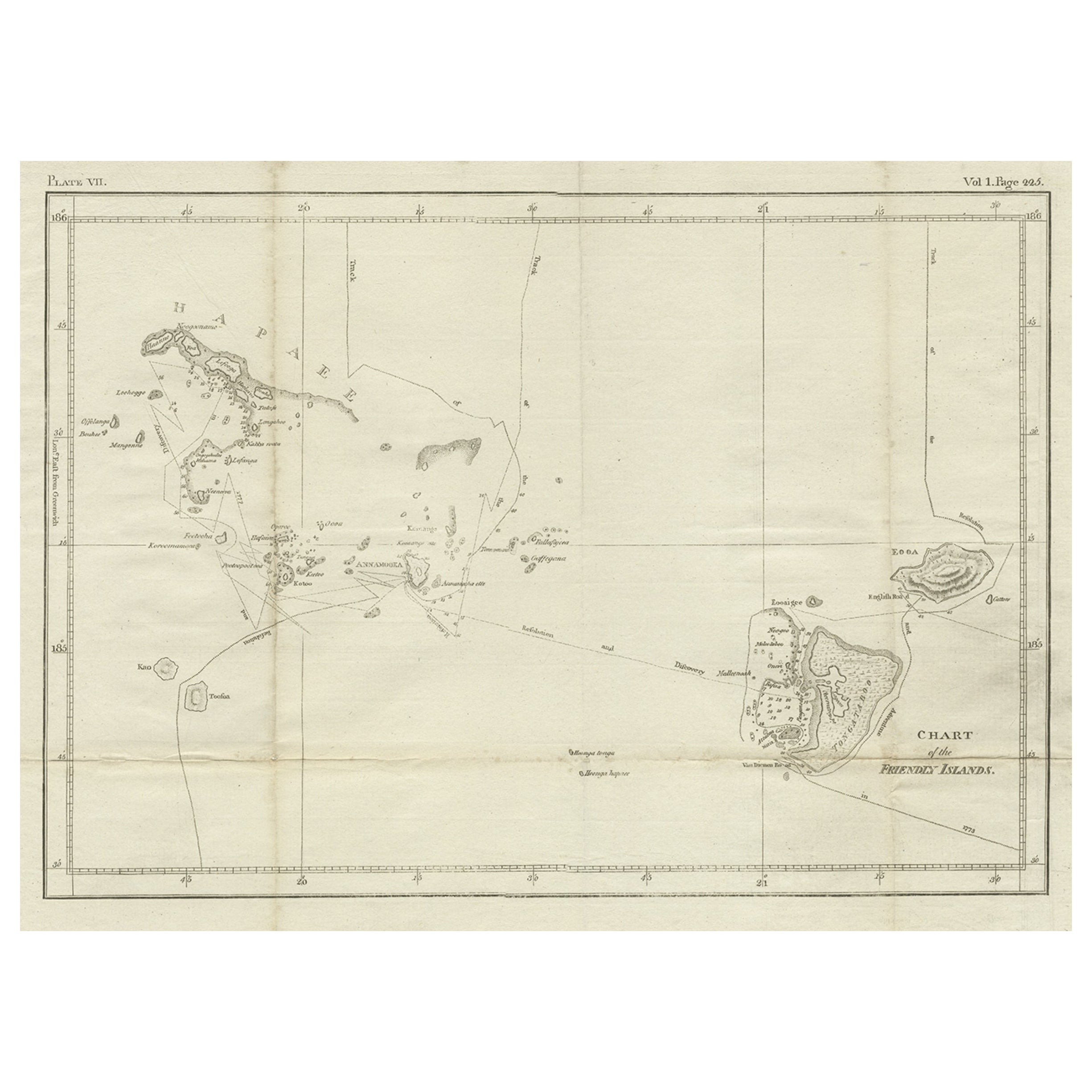
Antique Engraved Map of the Friendly Islands or Tonga, ca.1785
Located in Langweer, NL
Antique map titled 'Carte des Isles des Amis'.
Map of the Friendly Islands / Tonga. The Tongan people first encountered Europeans in 1616 when the Dutch vessel Eendracht, captain...
Category
Antique 1780s Maps
Materials
Paper

$305 Sale Price
20% Off
Antique Chart of the Friendly Islands or Nowadays Tonga, by Cook, 1784
By James Cook
Located in Langweer, NL
Antique print titled 'Chart of the Friendly Islands'. Antique map of the Friendly Islands depicting Rotterdam or Anamocka, Middelburg or Eaoowe and Amsterdam or Tongatabu. Originates...
Category
Antique 18th Century Prints
Materials
Paper
$325 Sale Price
20% Off
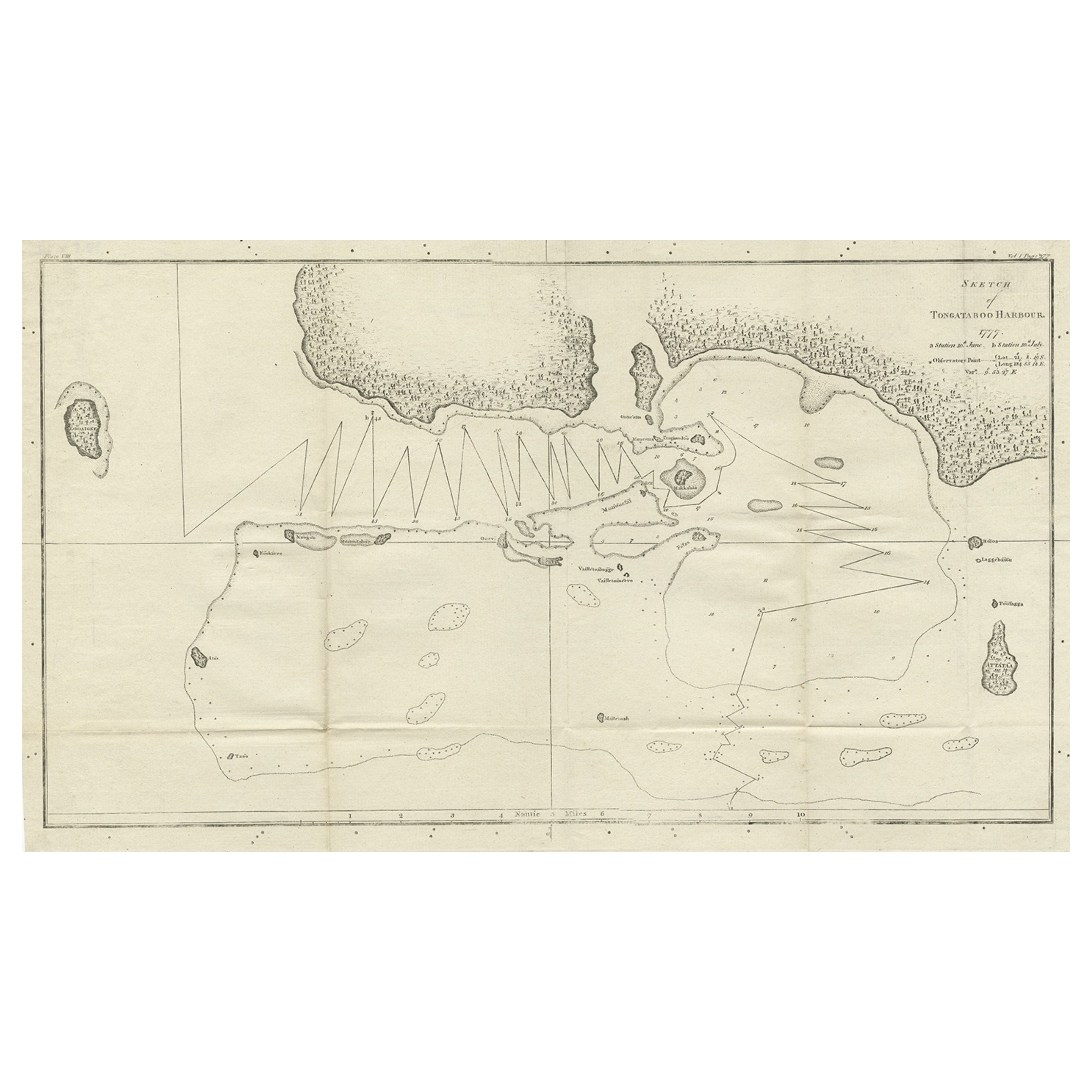
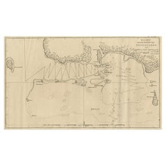
Antique Map of the Harbour of Tongatabu by Cook, C.1783
Located in Langweer, NL
Antique map titled 'Sketch of Tongataboo Harbour (..)'. Antique map of the harbour of Tongatabu, one of the Tonga Islands. Originates from an edition of Cook's Voyages.
Artists an...
Category
Antique 18th Century Maps
Materials
Paper
$325 Sale Price
20% Off
You May Also Like
Old Nautical Print by Engraving on Copper Plate from the Panckoucke Encyclopédie
Located in Milan, IT
Print by engraving on copper plate from the Panckoucke Encyclopédie méthodique, end of the 18th century, volume Marine Planches (more than 1,500 figures dealing with all subjects on the marina: planes, construction, carpentry, tree trunks, armaments of maneuvers, ropes, sails, artillery, ship maneuvers and combat tactics). This is the plate n. 149, page. 166 fig. 1209-1212; with frame cm 57.8 x 31.8. The prospect of the side of a ship is depicted. The Print has the "Benard direxit...
Category
Antique 1790s French Prints
Materials
Paper
Yacht Blueprint Showing Cabin of Sixty Two Foot Schooner
Located in Norwell, MA
Authentic Naval Architects Blueprint of a Sixty Two Foot Schooner designed by John Alden of Boston. The plan was drawn by C.G. McGregor. This is a ...
Category
Vintage 1920s North American Prints
Materials
Paper
Original Concorde Design Drawing, England, c. 1960
Located in Royal Tunbridge Wells, Kent
An extremely rare and original design drawing of the world renowned and much loved Concorde Aircraft. Concorde memorabilia is becoming more and mo...
Category
20th Century English Drawings
Materials
Paper
Original Drawing of a Forty-Eight Foot Yacht by George Lawley
Located in Norwell, MA
Excellent drawing of a proposed 48-foot express cruiser from George Lawley and Son Corporation, Yacht Builders, Neponset, Mass. Scale 1/2" equals one foot. Dated December 7, 1926. Tr...
Category
Vintage 1920s North American Nautical Objects
Materials
Paper
Original 1925 Yacht Blueprint from George Lawley of a 100-Foot Yacht
Located in Norwell, MA
1925 yacht blueprint of a one-hundred-foot private motor yacht. The plan is titled "Proposed Sketch for Motor Yacht" by George Lawley and Son Corporation, Neponset, Mass. Dated Septe...
Category
Vintage 1920s Nautical Objects
Materials
Paper
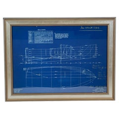
B.T. Dobson Boat Blueprint Design No. 72
Located in Norwell, MA
Original blueprint by naval architect Benjamin Dobson. This is identified as hull nos. 119 and 121, showing lines and offsets. This is a rich blue color, white outlines, also with ha...
Category
Vintage 1920s North American Prints
Materials
Paper
More Ways To Browse
1961 Picasso Exhibition
Aaa Lithograph
Alexander Wilson Birds
Antique Painting Pompeii
Arman Boom Boom
Audubon Havell Edition
Audubon Havell
Aurelia In A Red Bonnet
Avi Kiriaty
Bernard Munch
Bjorn Wiinblad Lithograph
Botero Hand Signed
Calder Artist Proof
Carol Summers Vintage Prints
Chagall Circus Signed
Charles Cobelle Signed Lithograph
Charles T Bowling
Christian Choisy