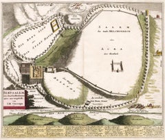
Items Similar to Plan of Ancient Jerusalem – Cornelis de Bruijn’s Engraved City View c.1698

Video Loading
Want more images or videos?
Request additional images or videos from the seller
1 of 12
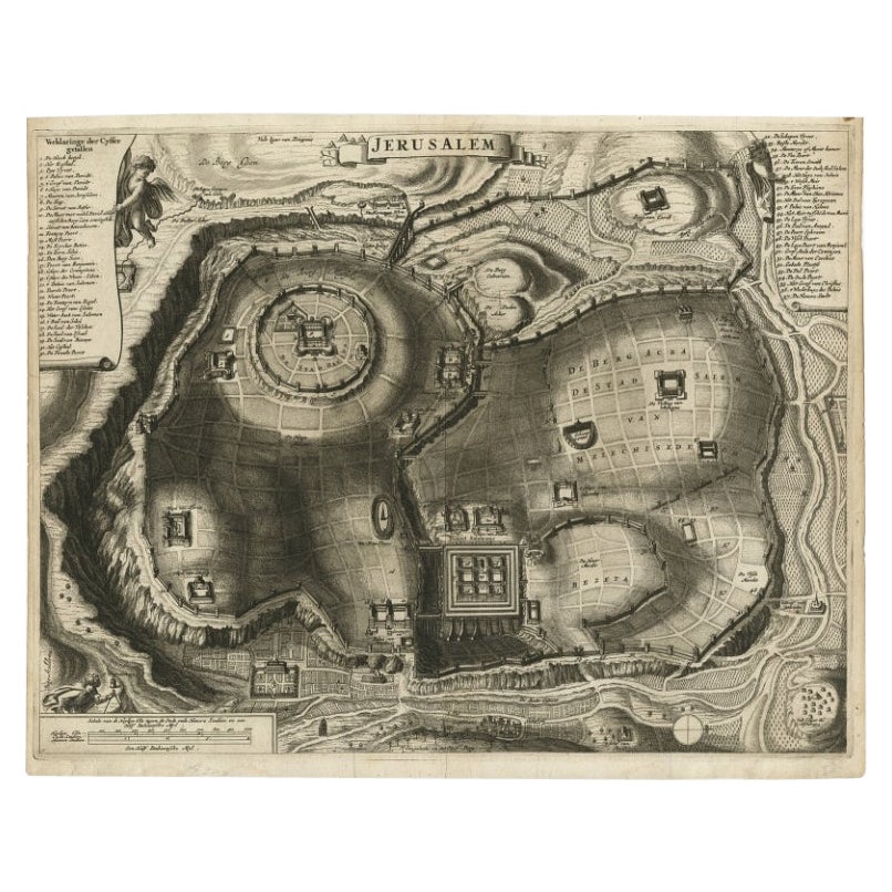
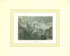
Plan of Ancient Jerusalem – Cornelis de Bruijn’s Engraved City View c.1698
$513.49
$641.8620% Off
£382.39
£477.9820% Off
€432
€54020% Off
CA$708.94
CA$886.1720% Off
A$785.96
A$982.4520% Off
CHF 413.05
CHF 516.3220% Off
MX$9,618.89
MX$12,023.6120% Off
NOK 5,158.62
NOK 6,448.2820% Off
SEK 4,841.88
SEK 6,052.3620% Off
DKK 3,289.10
DKK 4,111.3820% Off
About the Item
Plan of Ancient Jerusalem – Cornelis de Bruijn’s Engraved City View c.1698
This antique map titled Jerusalem is an intricate plan of the ancient city, richly detailed and marked with a comprehensive key identifying key locations and monuments. The engraving provides a bird’s-eye view of the city as it was imagined during biblical times, showing city walls, sacred sites, buildings, and landscape features with remarkable clarity and precision.
The map is attributed to Cornelis de Bruijn (1652 – c.1726/7), a Dutch artist, explorer, and chronicler known for his extensive travels and illustrated travel books. De Bruijn visited Jerusalem during his eastern journey in the late 17th century and was among the first Westerners to make widely accessible depictions of the city. This map likely stems from his celebrated publication Reizen van Cornelis de Bruyn door de vermaardste Deelen van Klein Asia (Voyages of Cornelis de Bruijn through the Most Celebrated Parts of Asia Minor), published in 1698.
De Bruijn’s works aimed to capture ancient cities not only as they appeared but also as they were imagined through historical and religious narratives. His map of Jerusalem, while not topographically accurate by modern standards, merges observation with idealized reconstruction, making it both a historical artifact and a devotional image. It became one of the most influential representations of the city during the late 17th and early 18th centuries.
Condition summary: Excellent impression with strong plate tone and fine detail. Minor marginal toning and one or two faint spots, not affecting the engraved surface. Paper remains stable and in very good condition, but some creases are to be seen.
Framing tips: This piece suits a classic, museum-style frame with a wide off-white or ivory mount and either black, walnut, or dark olive wood for contrast. Consider non-reflective UV-protective glass to preserve the quality of the paper and fine engraved lines.
- Dimensions:Height: 12.37 in (31.4 cm)Width: 14.97 in (38 cm)Depth: 0.02 in (0.5 mm)
- Materials and Techniques:Paper,Engraved
- Place of Origin:
- Period:Late 17th Century
- Date of Manufacture:1698
- Condition:Excellent impression with strong plate tone and fine detail. Minor marginal toning and one or two faint spots, not affecting the engraved surface. Paper remains stable and in very good condition, but some creases are to be seen.
- Seller Location:Langweer, NL
- Reference Number:Seller: BG-135831stDibs: LU3054336155082
About the Seller
5.0
Recognized Seller
These prestigious sellers are industry leaders and represent the highest echelon for item quality and design.
Platinum Seller
Premium sellers with a 4.7+ rating and 24-hour response times
Established in 2009
1stDibs seller since 2017
2,609 sales on 1stDibs
Typical response time: <1 hour
- ShippingRetrieving quote...Shipping from: Langweer, Netherlands
- Return Policy
Authenticity Guarantee
In the unlikely event there’s an issue with an item’s authenticity, contact us within 1 year for a full refund. DetailsMoney-Back Guarantee
If your item is not as described, is damaged in transit, or does not arrive, contact us within 7 days for a full refund. Details24-Hour Cancellation
You have a 24-hour grace period in which to reconsider your purchase, with no questions asked.Vetted Professional Sellers
Our world-class sellers must adhere to strict standards for service and quality, maintaining the integrity of our listings.Price-Match Guarantee
If you find that a seller listed the same item for a lower price elsewhere, we’ll match it.Trusted Global Delivery
Our best-in-class carrier network provides specialized shipping options worldwide, including custom delivery.More From This Seller
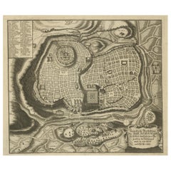
View AllAntique Detailed Map of Jerusalem in Israël with Extensive Key and Scale, 1698
Located in Langweer, NL
Antique map titled 'Jerusalem.'
Plan of the ancient city of Jerusalem. With extensive key and scale. Source unknown, to be determined.
Artists and Engravers: Made by 'Cornelis de...
Category
Antique 17th Century Maps
Materials
Paper

$618 Sale Price
20% Off
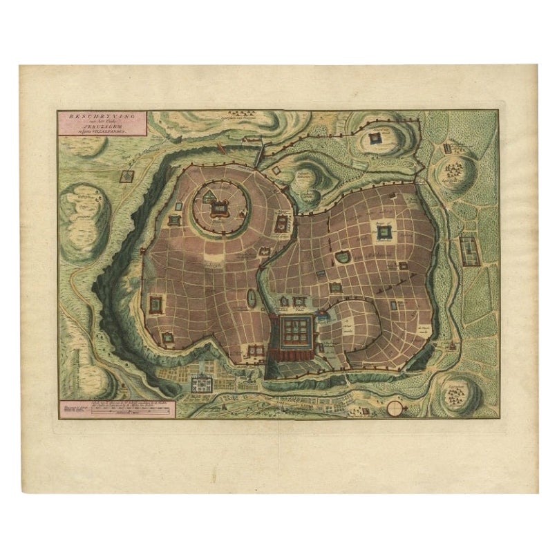
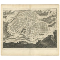
Bird's Eye Plan of the Ancient City of Jerusalem Based on Old Records, c.1725
Located in Langweer, NL
Antique map titled 'Beschryving van het oude Jeruzalem volgens Villalpandus.'
Bird's eye plan of the ancient city of Jerusalem based on Villalpando's foundation map. The plan shows...
Category
Antique 18th Century Maps
Materials
Paper

$618 Sale Price
20% Off
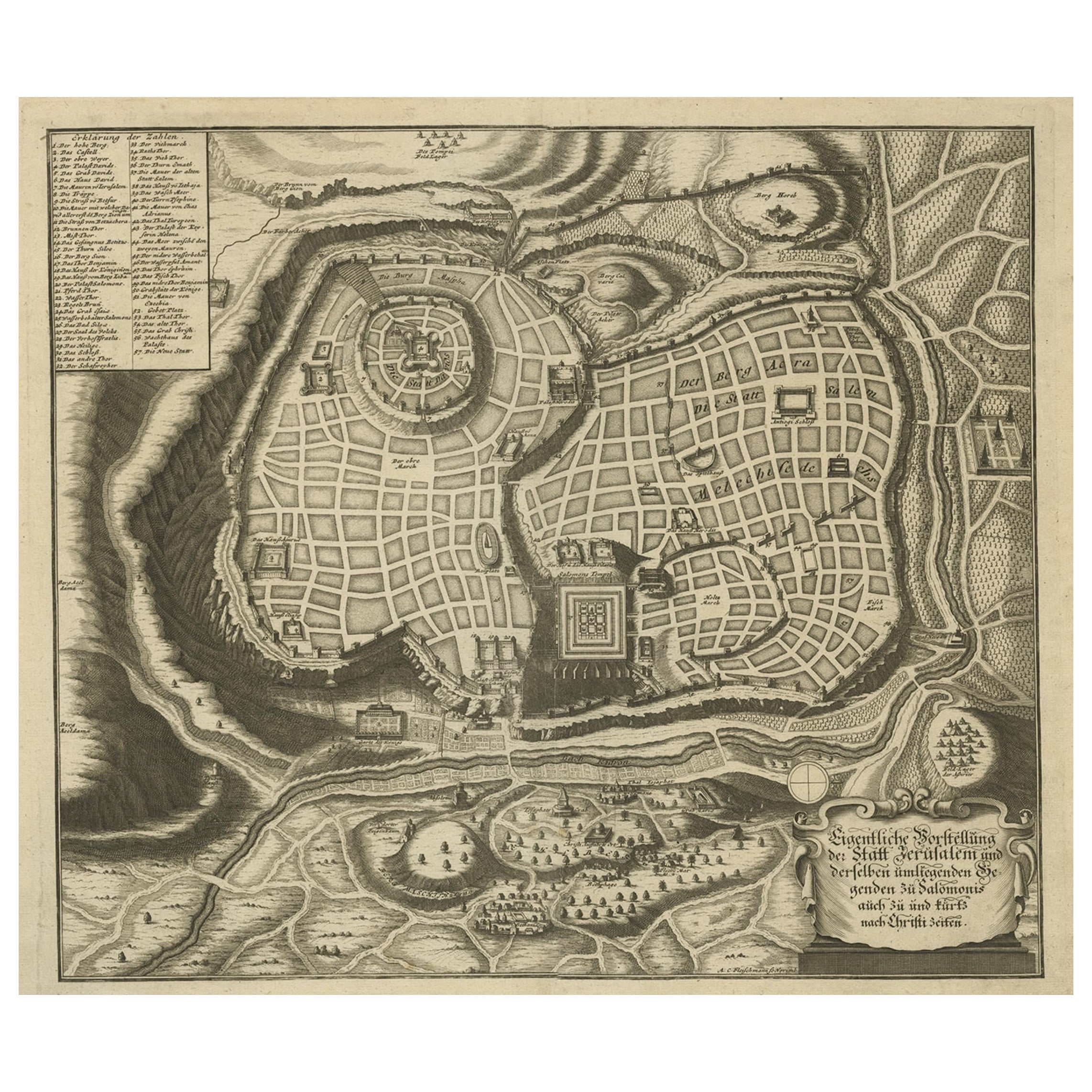
Rare Town Plan of Jerusalem, Includes an Extensive Key to Locations etc, 1708
Located in Langweer, NL
Antique map titled 'Eigentliche Vorstellung der Statt Jerusalem und derselben umliegenden Gegenden zu Salomonis auch zu und kurtz nach Christi Zeiten.'
Rare town plan...
Category
Antique Early 1700s Religious Items
Materials
Paper
$1,093 Sale Price
20% Off
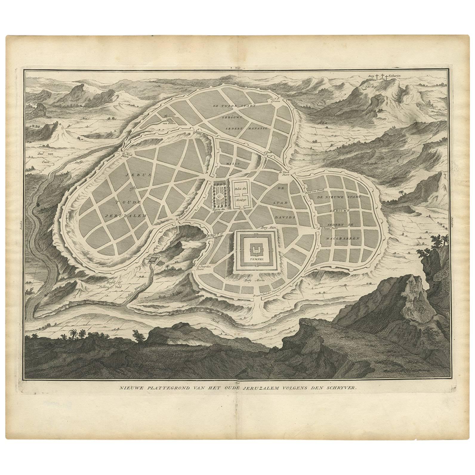
Antique Map of the Ancient City of Jerusalem by A. Calmet, 1725
Located in Langweer, NL
Antique map, titled: 'Nieuwe Plattegrond van het Oude Jeruzalem Volgens den Schryver.' - Bird's-eye view of the ancient city of Jerusalem shows its divisions with prominent depiction...
Category
Antique Early 18th Century Prints
Materials
Paper
$247 Sale Price
20% Off
Spectacular Antique Original Engraving of a Town Plan of Jerusalem, 1708
Located in Langweer, NL
Description: Antique map titled 'Erster Abriss der Stadt Jerusalem wie sie Furnemblich zur Zeit des Hernn Christi beschaffen (..).'
Spectacular town plan...
Category
Antique Early 1700s Maps
Materials
Paper

$1,283 Sale Price
20% Off
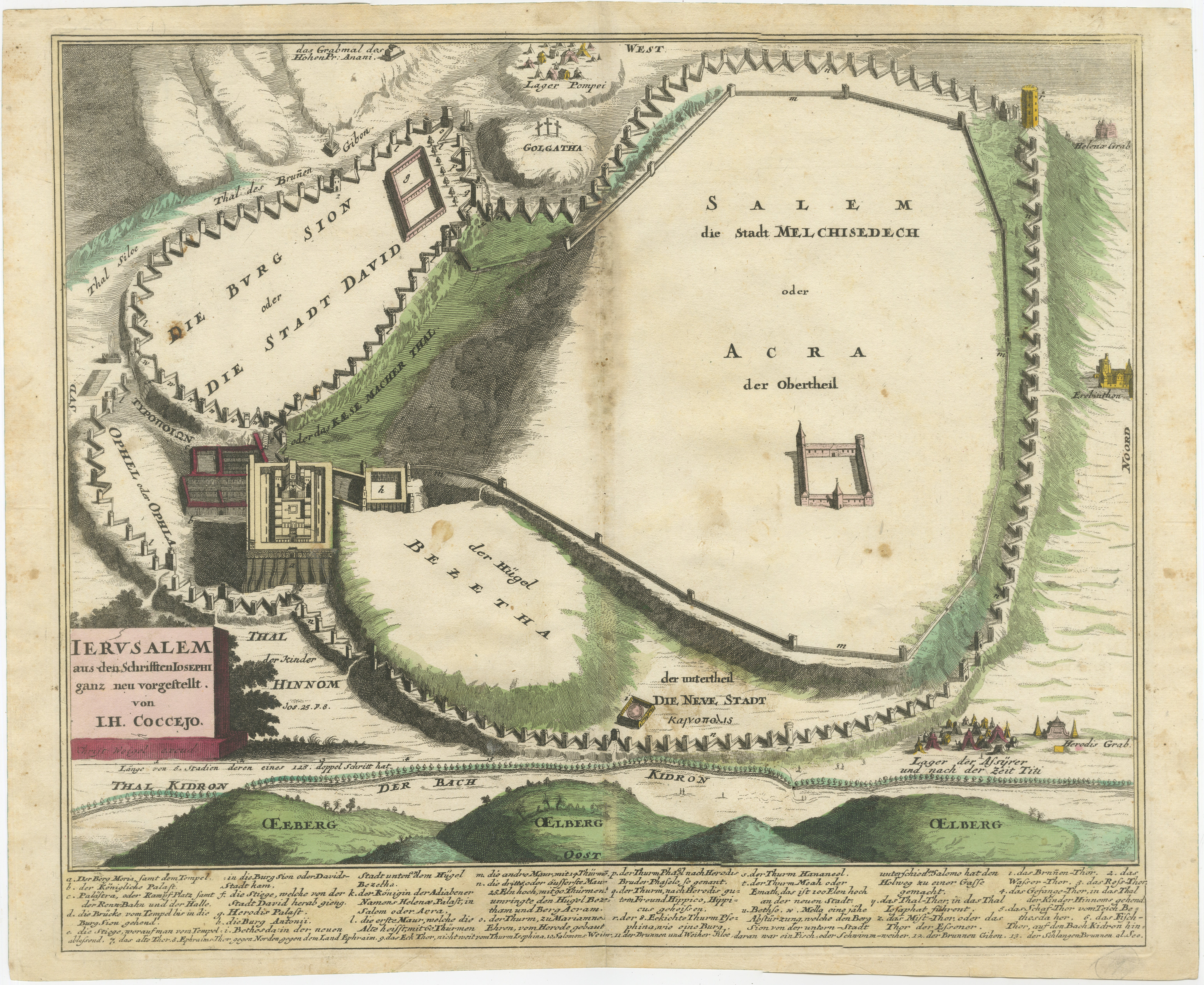
Original Antique Map of Jerusalem Based on Josephus' Writings by Weigel, ca.1720
Located in Langweer, NL
1720 Weigel Map of Jerusalem Based on Josephus' Writings
This intricate 1720 bird's-eye view map of ancient Jerusalem by I.H. Coccejo, engraved by Christoph Weigel, offers a fasc...
Category
Antique 1720s Maps
Materials
Paper

You May Also Like
Map of Biblical Jerusalem
Located in New York, NY
Original copper engraving hand-colored at the time of publication. Nuremberg, 1720.
Category
1720s Prints and Multiples
Materials
Paper
1597 German Map of Alexandria by Georg Braun and Frans Hogenberg
By Georg Braun and Frans Hogenberg
Located in Chapel Hill, NC
1597 Map of Alexandria by Georg Braun and Frans Hogenberg, Germany. From "Civitas Orbis Terrarum", part 2, published in Cologne by Bertram Buchholz. Printed in 2 parts. Title: "Alexa...
Category
Antique 16th Century German Renaissance Maps
Materials
Paper

17th-18th Century Siege of Graves Mapping Engraving By Willian III
Located in Kingston, NY
RARE French 17th-18th Century Enhanced Siege of Graves Mapping Engraving BY William III, also widely known as William of Orange,
The Siege of Grave in Dutch Brabant started by Monsie...
Category
Antique 17th Century French Prints
Materials
Paper

Ancient View of Jerusalem - Original Lithograph - Half of the 19th Century
Located in Roma, IT
Ancient View of Jerusalem is an original modern artwork realized in the first half of the 19th Century.
Original B/W Lithograph on Ivory Paper.
Inscripted on the lower margin in ...
Category
Mid-19th Century Modern Landscape Prints
Materials
Lithograph
Original Antique Map or City Plan of Geneva, Switzerland. Circa 1835
Located in St Annes, Lancashire
Nice map of Geneva
Drawn and engraved by J.Dower
Published by Orr & Smith. C.1835
Unframed.
Free shipping
Category
Antique 1830s English Maps
Materials
Paper

Vintage Print Map of Jerusalem With Wooden Frame
Located in Seattle, WA
Historic Print of Original Oil Painting by Fr. & R. Stegmiller of Jerusalem in 1928. Primarily Red and Yellow Tones as Pictured. Vintage Condition Consistent with Age as Pictured.
D...
Category
Vintage 1970s Mid-Century Modern Paintings
Materials
Wood
More Ways To Browse
Jerusalem Furniture
Stripped Oak Buffet
Thai Rattanakosin
Tortoise Shell Victorian
Tv Cabinet 1950s
Used Chasuble
Used Concrete Fountains
Used English Horse Saddles
Victorian Silver Plate Vases
Vintage Black Cat Figurines
Vintage China Cabinet Hutch
Vintage Chubby
Vintage Mottahedeh
Vintage Nasa Photos
Vintage Stash Box
Vintage Travel Alarm Clock
Violin Table
W Hodges