1 of 1
Richardson's New Map of the State of Texas
$7,995List Price
About the Item
- Creator:Willard Richardson 1 (Artist),Charles Desilver (Author)
- Dimensions:Height: 22.75 in (57.79 cm)Width: 30.25 in (76.84 cm)Depth: 0.5 in (1.27 cm)
- Style:Other (Of the Period)
- Place of Origin:
- Period:
- Date of Manufacture:1860
- Condition:Wear consistent with age and use. Minor fading.
- Seller Location:Houston, TX
- Reference Number:1stDibs: LU129322134202
Authenticity Guarantee
In the unlikely event there’s an issue with an item’s authenticity, contact us within 1 year for a full refund. DetailsMoney-Back Guarantee
If your item is not as described, is damaged in transit, or does not arrive, contact us within 7 days for a full refund. Details24-Hour Cancellation
You have a 24-hour grace period in which to reconsider your purchase, with no questions asked.Vetted Professional Sellers
Our world-class sellers must adhere to strict standards for service and quality, maintaining the integrity of our listings.Price-Match Guarantee
If you find that a seller listed the same item for a lower price elsewhere, we’ll match it.Trusted Global Delivery
Our best-in-class carrier network provides specialized shipping options worldwide, including custom delivery.You May Also Like
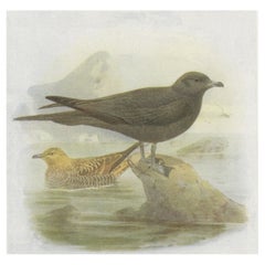
Antique Bird Print of Richardson's Skua, 1907
Located in Langweer, NL
Antique Bird Print of Richardson's Skua. This print originates from 'Birds of Britain' by J. Lewis Bonhote.
Artists and Engravers: J. Lewis Bonhote was an English ornithologist. ...
Category
20th Century Prints
Materials
Paper
Original Antique Map of the State of New Jersey Published in France
Located in Langweer, NL
Original antique map titled 'Carte Géographique Statistique et Historique du New-Jersey'. One of the earliest obtainable maps of the State of New Jersey published outside of the Unit...
Category
Antique Early 19th Century Maps
Materials
Paper
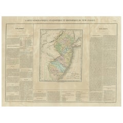
$191 Sale Price
20% Off
H 20.99 in W 26.78 in D 0.02 in
Antique Map of the Eastern United States with Inset Map of Texas
Located in Langweer, NL
Antique map titled 'Verein-Staaten von Nord-America mit Ausnahme Florida's und der Westlichen Territorien'. This map extends as far west as Louisiana and only includes the northern p...
Category
Antique Mid-19th Century Maps
Materials
Paper

$515 Sale Price
20% Off
H 14.65 in W 17.84 in D 0.02 in
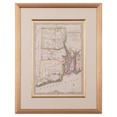
The State of Rhode Island Map - Caleb Harris & Harding Harris, 1818
Located in Savannah, GA
Mathew Carey
(American/Philadelphia, 1760-1839)
The State of Rhode Island compiled from the surveys and observations of Caleb Harris by Harding Harris. Engraving with hand-coloring...
Category
Antique 1810s American Other Prints
Materials
Glass, Wood, Paper
Antique Map of the Region of Georgia with Inset Maps of Florida and Texas
Located in Langweer, NL
Antique map of part of the United States showing Alabama, Georgia, North Carolina, South Carolina, Tennessee, Kentucky, Virginia and part of Florida. With inset maps of the southern ...
Category
Antique Late 19th Century Maps
Materials
Paper
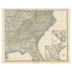
$525 Sale Price
50% Off
H 15.04 in W 18.63 in D 0.02 in
Beautiful First State Map of Friesland, the Netherlands, c.1665
Located in Langweer, NL
Antique map titled 'Dominii Frisiae Tabula, inter Flevum et Lavicam'. Beautiful first state map of Friesland, the Netherlands. With small inset map of the Frisian Wadden islands Vlie...
Category
Antique 17th Century Maps
Materials
Paper
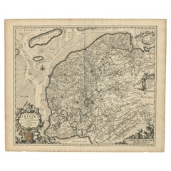
$835 Sale Price
20% Off
H 20.87 in W 24.81 in D 0 in
Antique Map of the State of Ohio by Titus '1871'
Located in Langweer, NL
Antique map titled 'Railroad & Township Map of the State of Ohio'. Original antique map of the State of Ohio. This map originates from 'Atlas of Preble County Ohio' by C.O. Titus. Pu...
Category
Antique Late 19th Century Maps
Materials
Paper

$1,074 Sale Price
25% Off
H 16.54 in W 26.78 in D 0.02 in
Antique 18th Century Map of the Province of Pensilvania 'Pennsylvania State'
Located in Philadelphia, PA
A fine antique of the colony of Pennsylvania.
Noted at the top of the sheet as a 'Map of the province of Pensilvania'.
This undated and anonymous map is thought to be from the Gentleman's Magazine, London, circa 1775, although the general appearance could date it to the 1760's.
The southern boundary reflects the Mason-Dixon survey (1768), the western boundary is placed just west of Pittsburgh, and the northern boundary is not marked.
The map has a number of reference points that likely refer to companion text and appear to be connected to boundaries. The western and southern boundaries are marked Q, R, S, for example. A diagonal line runs from the Susquehanna R to the Lake Erie P. A broken line marked by many letters A, B, N, O, etc., appears in the east.
There are no latitude or longitude markings, blank verso.
Framed in a shaped contemporary gilt wooden frame and matted under a cream colored matte.
Bearing an old Graham Arader Gallery...
Category
Antique 18th Century British American Colonial Maps
Materials
Paper

$1,250
H 10.25 in W 13.25 in D 0.5 in
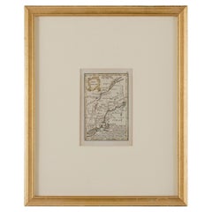
John Gibson - Map of New England
Located in Savannah, GA
A miniature map of New England from John Gibson’s The Atlas Minimus published in 1758.
John Gibson worked in London from 1748-1773 as a geographer and engraver, producing numerous ...
Category
Antique 1750s British Other Prints
Materials
Glass, Paper
Vintage School Map Of Czech State, Czechoslovakia 1960s
Located in Zohor, SK
This is a great vintage school map of "Czech State1526-1648". The map was produced by a National company Skolske Pomocky (School accessories) in 1960s in Czechoslovakia. This map was...
Category
Vintage 1960s Czech Mid-Century Modern Prints
Materials
Wood, Paper
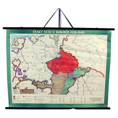
$163 Sale Price
75% Off
H 33.47 in W 44.1 in D 1.19 in
Recently Viewed
View AllMore Ways To Browse
La Mode Illustree Prints Antique
La Mode Illustree
The Great Exhibition Furniture
Used Anatomy Skeleton
Versaille Engraving
Antique Dog Sleds
Antique Fox Hunt Prints
Antique Furniture Wiltshire
Antique Japanese Parasol
Antique Print Fruit And Palm Tree
Antique Prints Melbourne
Antique Sea Life Prints
Argus Pheasant
Carlo Antonini
Framed Piranesi
Large Serigraph Modern
Maid Servant
Martinet Birds