Items Similar to 1710 Edward Wells Detailed Ancient Greece Map with Ornate Cartouche


Want more images or videos?
Request additional images or videos from the seller
1 of 16
1710 Edward Wells Detailed Ancient Greece Map with Ornate Cartouche
$739.16
$923.9520% Off
£545.10
£681.3820% Off
€616
€77020% Off
CA$1,020.77
CA$1,275.9720% Off
A$1,120.03
A$1,400.0420% Off
CHF 586.17
CHF 732.7120% Off
MX$13,783.78
MX$17,229.7220% Off
NOK 7,384.88
NOK 9,231.1020% Off
SEK 6,917.04
SEK 8,646.3020% Off
DKK 4,691.60
DKK 5,864.5020% Off
About the Item
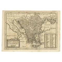
"1710 Edward Wells Map of Ancient Greece: A New Map of Antient Greece, Tirana, Morea, Ilyricum, Sicily, and Macedonia"
Description of the Map:
This map, produced around 1710 and engraved by E. Smith, originates from Edward Wells' "Ancient and Present Geography." It offers a detailed depiction of ancient Greece, including regions like Tirana, Morea (Peloponnese), Ilyricum (parts of the western Balkans), Sicily, and Macedonia. This version is especially notable for its incorporation of historical and geographical scholarship, aimed at providing a comprehensive view of these ancient regions.
Geographic and Artistic Details:
- Coverage: The map covers a significant part of southeastern Europe and includes parts of modern-day Greece, Albania, North Macedonia, and Sicily. It accurately portrays ancient cities, rivers, and topographical features, with boundaries that reflect historical divisions.
- Artistic Elements: A large, ornate coat of arms cartouche enhances the map’s aesthetic, dedicated to "His Highness William Duke of Gloucester." This element not only adds visual appeal but also underscores the map’s dedication and purpose.
- Scale: The map includes two scales of English miles, each according to different computations (Picart's and Reclusolli's), showing the period's engagement with precise cartographic measurement.
Condition:
- Preservation: The map shows some signs of age, including weak fold lines at the lower central fold, but these do not significantly detract from its overall appearance or utility.
Historical and Collectible Value:
This map serves as a valuable artifact for collectors interested in the cartography of ancient geographical regions as interpreted in the early 18th century. Edward Wells was known for his detailed and scholarly approach to mapping, making this piece a significant acquisition for those interested in the historical depiction of Greece and its neighboring areas. Its dedication to a historical figure adds to its narrative and desirability among collectors, particularly those with an interest in the intersection of cartography and royal patronage.
- Dimensions:Height: 17.92 in (45.5 cm)Width: 23.23 in (59 cm)Depth: 0 in (0.02 mm)
- Materials and Techniques:Paper,Engraved
- Period:1710-1719
- Date of Manufacture:1710
- Condition:Good. General age-related toning and/or occasional minor defects from handling. The map shows some signs of age, including weak fold lines at the lower central fold, but these do not significantly detract from its overall appearance or utility.
- Seller Location:Langweer, NL
- Reference Number:Seller: BG-13645-21stDibs: LU3054341306952
About the Seller
5.0
Recognized Seller
These prestigious sellers are industry leaders and represent the highest echelon for item quality and design.
Platinum Seller
Premium sellers with a 4.7+ rating and 24-hour response times
Established in 2009
1stDibs seller since 2017
2,620 sales on 1stDibs
Typical response time: <1 hour
- ShippingRetrieving quote...Shipping from: Langweer, Netherlands
- Return Policy
Authenticity Guarantee
In the unlikely event there’s an issue with an item’s authenticity, contact us within 1 year for a full refund. DetailsMoney-Back Guarantee
If your item is not as described, is damaged in transit, or does not arrive, contact us within 7 days for a full refund. Details24-Hour Cancellation
You have a 24-hour grace period in which to reconsider your purchase, with no questions asked.Vetted Professional Sellers
Our world-class sellers must adhere to strict standards for service and quality, maintaining the integrity of our listings.Price-Match Guarantee
If you find that a seller listed the same item for a lower price elsewhere, we’ll match it.Trusted Global Delivery
Our best-in-class carrier network provides specialized shipping options worldwide, including custom delivery.More From This Seller
View AllAntique Map Eastern Mediterranean by D. Stoopendaal 'circa 1710'
Located in Langweer, NL
Antique map Middle East titled 'De Beschryving van de Reysen Pauli en van de Andere Apostelen'. Antique map of the Eastern Mediterranean with details of the travels by Apostle Paul...
Category
Antique Early 18th Century Dutch Maps
Materials
Paper

$335 Sale Price
20% Off
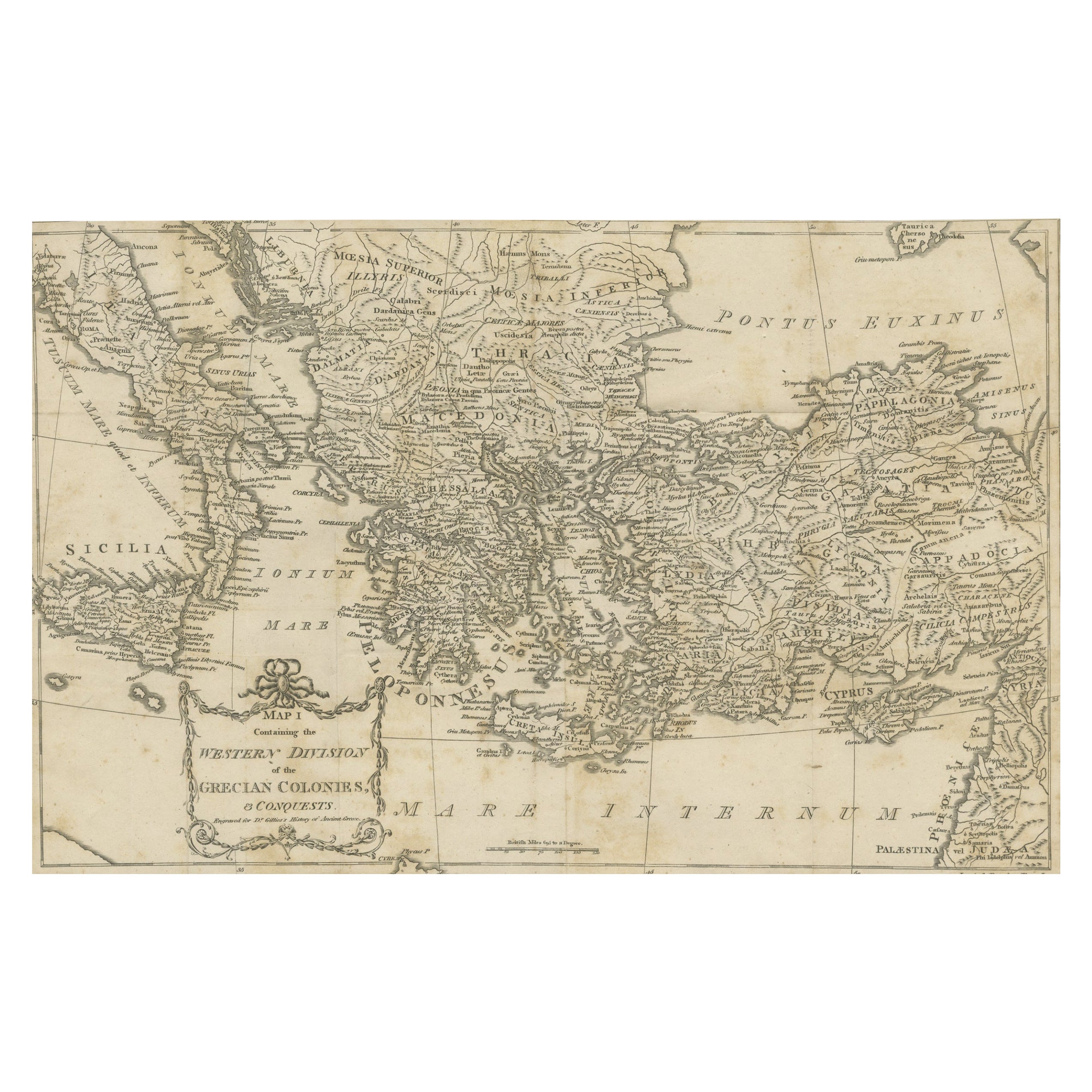
Antique Map of the Ancient Greek Colonization
Located in Langweer, NL
Antique map titled 'Map I containing the Western Division of the Grecian Colonies & Conquests'. Original antique map of the ancient Greek colonization. Frontispiece map of 'The Histo...
Category
Antique Late 18th Century Maps
Materials
Paper
$172 Sale Price
20% Off
Antique Map of the Eastern Mediterranean, C.1710
Located in Langweer, NL
Antique map Middle East titled 'De Beschryving van de Reysen Pauli en van de Andere Apostelen'. Antique map of the Eastern Mediterranean with det...
Category
Antique 18th Century Maps
Materials
Paper

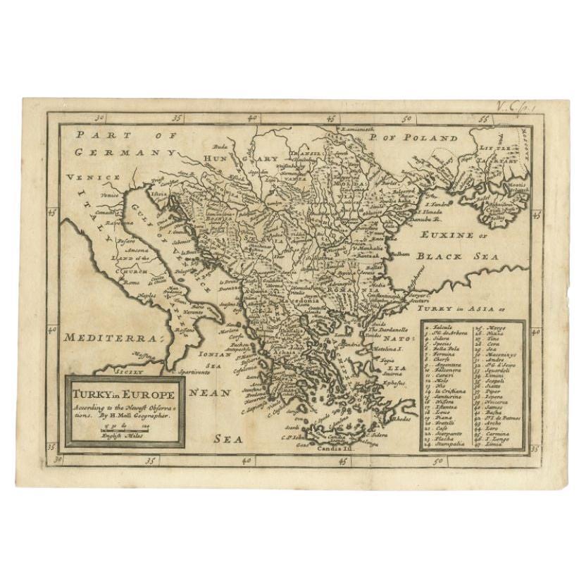
Detailed Original Antique Map of Turkey in Europe, circa 1740
Located in Langweer, NL
Antique map Turkish Empire tilted 'Turky in Europe'. Beautiful, small antique map depicting modern-day Greece and surroundings. Source unknown, to be determined.
Artists and Engra...
Category
Antique 18th Century Maps
Materials
Paper
$326 Sale Price
20% Off
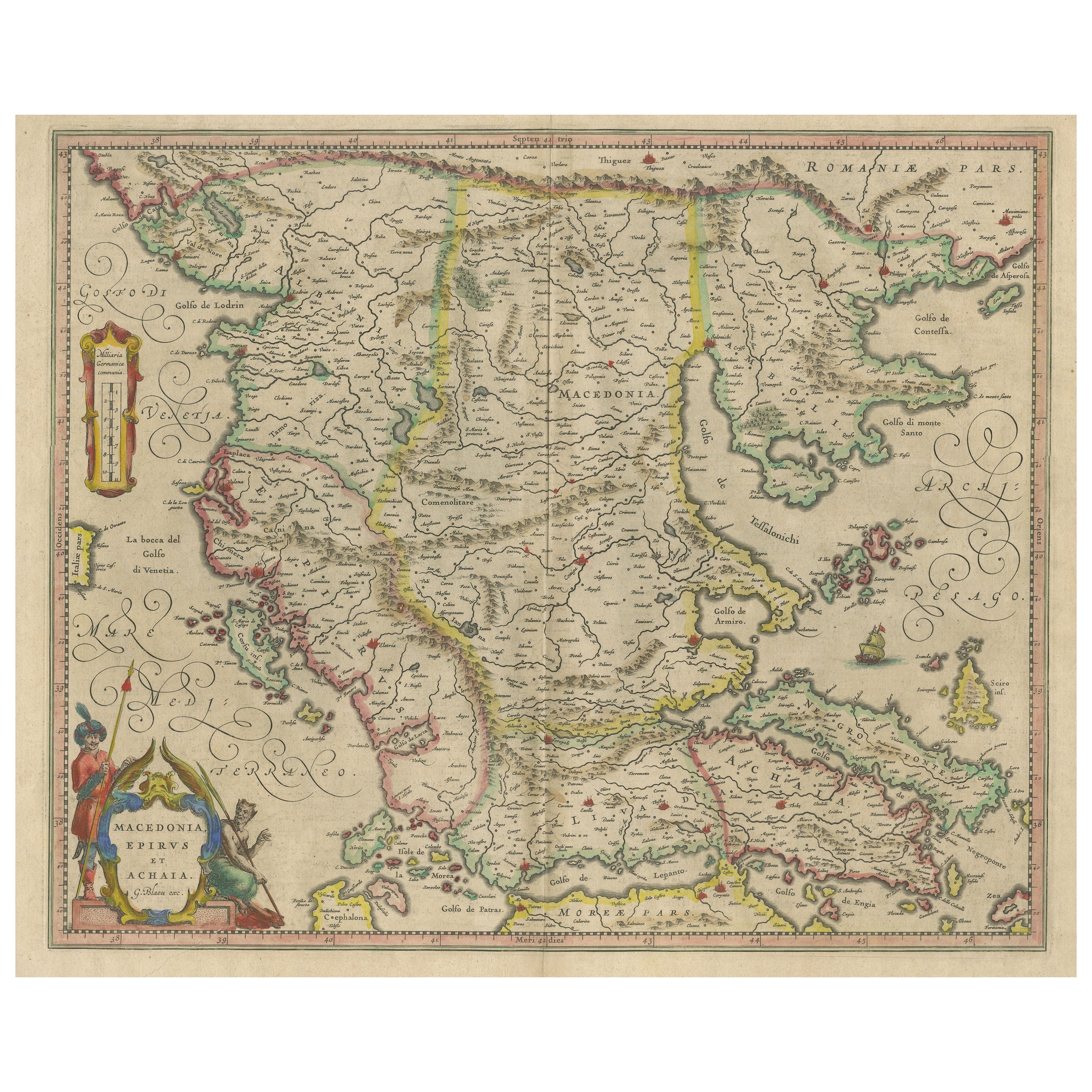
Antique Map of Macedonia, Northern Greece and part of Turkey in Europe
Located in Langweer, NL
Antique map titled 'Macedonia Epirus et Achaia'. Original old map of Macedonia, northern Greece, and part of Turkey in Europe. Published by W.J. Blaeu, circa 1640.
Willem Janszoon ...
Category
Antique Mid-17th Century Maps
Materials
Paper
$767 Sale Price
20% Off
Antique Map of Greece, Albania, Macedonia and Parts of Turkey and Cyprus, c.1745
Located in Langweer, NL
Antique map titled 'Accurata Totius Archipelagi Et Graeciae Universae Tabula'.
Detailed map of Greece. Includes Albania, Macedonia and parts of Turkey and Cyprus. With compass rose...
Category
Antique 18th Century Maps
Materials
Paper

$815 Sale Price
20% Off
You May Also Like
1627 Hendrik Hondius Map Entitled "Vltoniae Orientalis Pars, " Ric.a009
Located in Norton, MA
1627 Hendrik Hondius map entitled
"Vltoniae orientalis pars,"
Ric.a009
Title:
Vltoniae orientalis : pars
Title (alt.) :
Ultoniae orientalis pars
Creator:
Mercator, Gerh...
Category
Antique 17th Century Dutch Maps
Materials
Paper

1633 Map "La Souverainete De Sedan Et De Raucourt, Et La Prevoste Ric0011
Located in Norton, MA
1653 map entitled
"La Souverainete de Sedan et de Raucourt, et la Prevoste de Doncheri,"
Ric0011
Description:
Lovely map centered on Sedan and Doncheri and the Meuze River fr...
Category
Antique 17th Century Dutch Maps
Materials
Paper

Original Antique Map of Ancient Greece, Achaia, Corinth, 1786
Located in St Annes, Lancashire
Great map of Ancient Greece. Showing the region of Thessaly, including Mount Olympus
Drawn by J.D. Barbie Du Bocage
Copper plate engraving by P.F Tardieu
Original hand color...
Category
Antique 1780s French Other Maps
Materials
Paper

1718 Ides & Witsen Map "Route D'amsterdam a Moscow Et De La Ispahan Et Gamron
Located in Norton, MA
1718 Ides & Witsen map, entitled
"Route D'Amsterdam A Moscow Et De La Ispahan Et Gamron,"
Ric.b005
Subject: Eastern Europe and Central Asia
Period: 1718 (published)
Publicati...
Category
Antique Early 18th Century Dutch Maps
Materials
Paper

17th Century Nicolas Visscher Map of Southeastern Europe
Located in Hamilton, Ontario
A beautiful, highly detailed map of southeastern Europe by Nicolas Visscher. Includes regions of Northern Italy (showing the cities Bologna, Padua, and Venice), Bohemia, Austria (sho...
Category
Antique 17th Century Dutch Maps
Materials
Paper

$1,350 Sale Price
38% Off
18th Century Map of the Southern Balkans by Giovanni Maria Cassini
By Giovanni Maria Cassini
Located in Hamilton, Ontario
18th century map by Italian engraver Giovanni Maria Cassini (Italy 1745-1824).
Map of the Southern Balkans: Rome. Hand colored and copper engraved print done in the year 1788. It in...
Category
Antique 18th Century Italian Maps
Materials
Paper

$795 Sale Price
36% Off
More Ways To Browse
Antique Cartouche
Antique English Scales
Ancient Greek Furniture
Orange Coffee Table
Round Brass Table
Set Of Four Italian Dining Chairs
Black And Chrome Lounge Chair
Pedestal Mahogany Dining Table
Round Table Base
Metal Coffee Table 1970s
Wash Stand
18th Century Blue And White Porcelain
Antique Imari Porcelain
Antique Pagoda
Belgian Antiques
Italian Lacquer Dining Room Sets
Paisley Rugs and Carpets
Vintage Scandinavian Armchairs