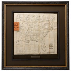
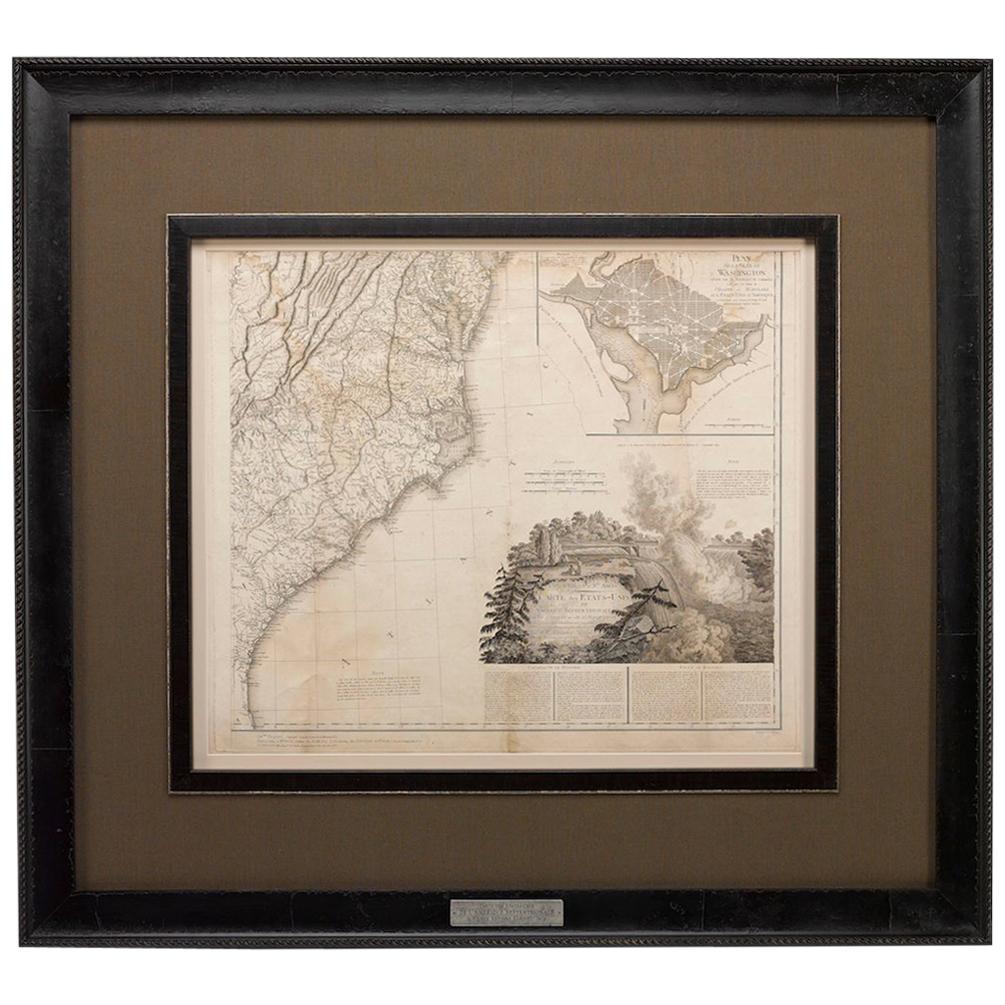
"Historical Civil War Map" Antique U.S. Pocket Map by Asher and Co., 1862
View Similar Items


Want more images or videos?
Request additional images or videos from the seller
1 of 5
"Historical Civil War Map" Antique U.S. Pocket Map by Asher and Co., 1862
About the Item
- Dimensions:Height: 43.5 in (110.49 cm)Width: 42.75 in (108.59 cm)Depth: 2.5 in (6.35 cm)
- Materials and Techniques:
- Place of Origin:
- Period:
- Date of Manufacture:1862
- Condition:Wear consistent with age and use. Overall good condition. Originally a folding pocket map, fold lines are present with some wear. Coloring is still quite vibrant and visible.
- Seller Location:Colorado Springs, CO
- Reference Number:Seller: M1471stDibs: LU909717759772
About the Seller
4.9
Platinum Seller
These expertly vetted sellers are 1stDibs' most experienced sellers and are rated highest by our customers.
Established in 2010
1stDibs seller since 2011
402 sales on 1stDibs
More From This SellerView All
- 1812 United States Map, by Pierre Tardieu, Antique French Map Depicting the U.S.By Pierre François TardieuLocated in Colorado Springs, CO1812 "United States of Nth America -- Carte des Etats-Unis De L'Amerique Septentrionale" Two-Sheet Map by Tardieu This attractive map, published in Paris in 1812, is one of the most rare large format maps from the period. It features a view of the East Coast of the U.S. from Maryland to just below South Carolina. Additionally, Ellicott’s plan for the City of Washington D.C. is included at the top right and an illustration of Niagara Falls is shown at the bottom right with a description in both French and English. This extremely detailed map not only depicts the mountainous regions of the southeastern U.S., but also includes names of regions, rivers, and towns. Based on the first state of Arrowsmith’s 4-sheet map of the United States, this map is completely engraved by Tardieu in Paris and showcases high quality engravings. This detailed map of the recently independent United States includes one of the largest and earliest examples of the Ellicott plan of Washington DC. The artist, Pierre François Tardieu (PF Tardieu) was a very well-known map engraver, geographer, and illustrator. Awarded a bronze medal by King Louis-Phillipe for the accuracy and beauty of his map-making, Tardieu produced many fine works including maps of Louisiana...Category
Antique 1810s French Maps
MaterialsPaper
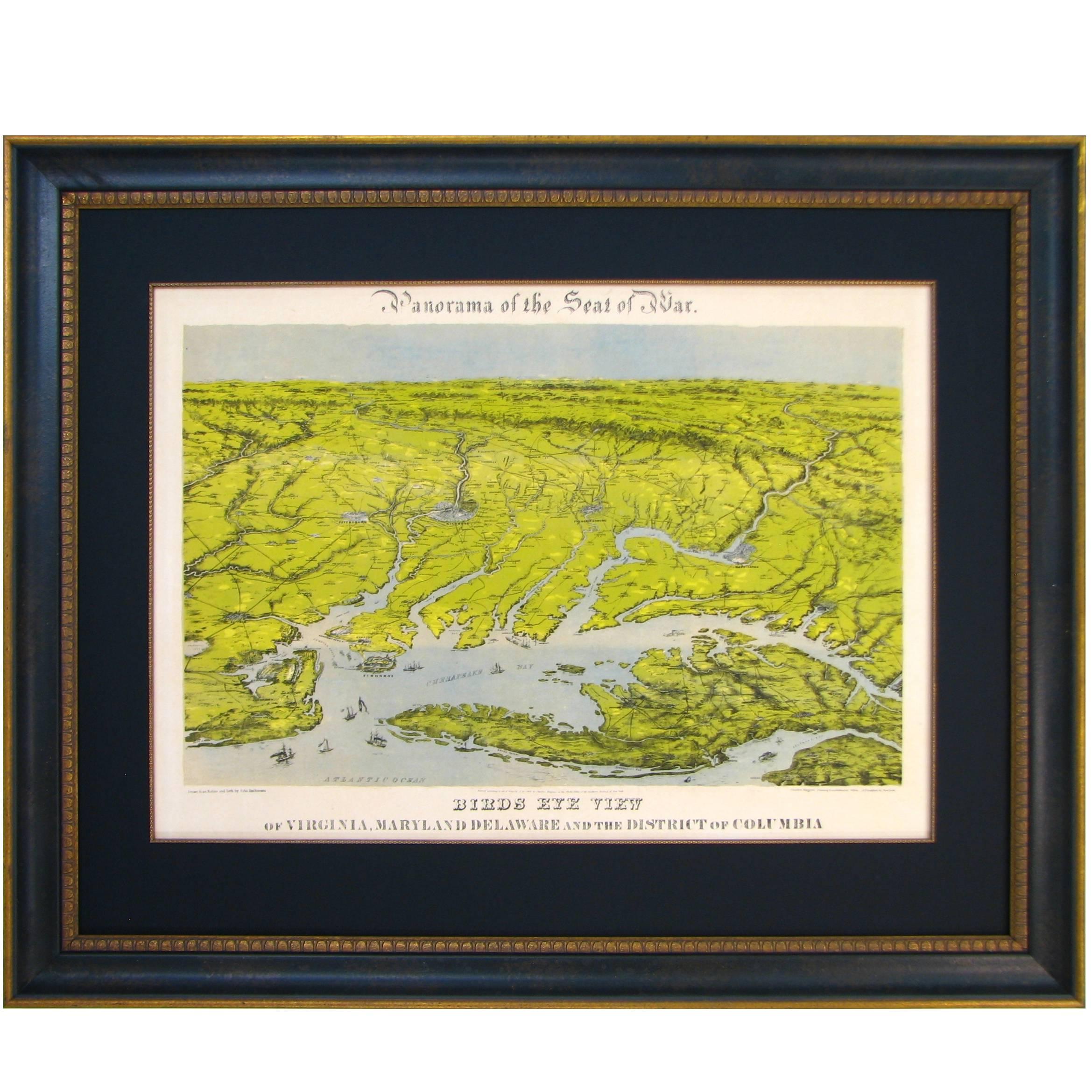
- Civil War Panorama of the Seat of War by John Bachmann, Antique Print circa 1864Located in Colorado Springs, COPanorama of the seat of war. Bird's-eye View of Virginia, Maryland, Delaware and the District of Columbia. This third state of this fascinating bird's eye view of the northernmost p...Category
Antique 1860s American Maps
MaterialsPaper
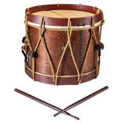
- Civil War-Era Side Drum, Made by George Kilbourn, 1859Located in Colorado Springs, COPresented is an original Civil War-era side drum with a pair of wooden drumsticks. This is a rope tension drum with a wooden body, ropes, and leather tabs. An iron tack pattern surro...Category
Antique 1850s American American Classical Musical Instruments
MaterialsIron
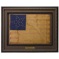
- 34-Star Civil War American Flag, Antique Great Star Pattern, circa 1861Located in Colorado Springs, COThe stars of this extremely rare, Civil War-era flag are arranged in what is sometimes called the "Great Flower" pattern, a large star made out of smaller stars -- named as such beca...Category
Antique 1860s American Political and Patriotic Memorabilia
MaterialsLinen
 $15,500 Sale Price37% Off
 - 1856 U.S. Coast Survey Map of Chesapeake Bay and Delaware BayLocated in Colorado Springs, COPresented is U.S. Coast Survey nautical chart or maritime map of Chesapeake Bay and Delaware Bay from 1856. The map depicts the region from Susquehanna, Maryland to the northern Outer Banks in North Carolina. It also shows from Richmond and Petersburg, Virginia to the Atlantic Ocean. The map is highly detailed with many cities and towns labeled throughout. Rivers, inlets, and bays are also labeled. Various charts illustrating more specific parts of the region are marked on the map using dotted lines. The lines form boxes, and the corresponding chart number and publication date are given. Extensive triangulation surveys were conducted the length of Chesapeake Bay and are illustrated here. Hampton Roads, Virginia is labeled, along with the James, York, and Rappahannock Rivers, which were all extensively surveyed. The chart was published under the supervision of A. D. Bache, one of the most influential and prolific figures in the early history of the U.S. Coast Survey, for the 1856 Report of the Superintendent of the U.S. Coast Survey. Alexander Dallas Bache (1806-1867) was an American physicist, scientist, and surveyor. Bache served as the Superintendent of the U.S. Coast Survey from 1843 to 1865. Born in Philadelphia, Bache toured Europe and composed an important treatise on European Education. He also served as president of Philadelphia's Central High School and was a professor of natural history and chemistry at the University of Pennsylvania. Upon the death of Ferdinand Rudolph Hassler, Bache was appointed Superintendent of the United States Coast Survey. The Office of the Coast Survey, founded in 1807 by President Thomas Jefferson and Secretary of Commerce Albert Gallatin...Category
Antique 1850s American Maps
MaterialsPaper
- U.S. Navy League, "War Clouds Gather!" by Hazel Roberts, Vintage Poster, 1916Located in Colorado Springs, COThis propaganda poster was designed by Hazel Roberts (1883-1966) to encourage onlookers to join the U.S. Navy League. The poster was issued in 1916 and features a depiction of a Navy soldier facing the horizon and playing a bugle. The text at bottom reads "War Clouds Gather! Manhood willing but unarmed. Help the Navy-Join the Navy League/ Local Headquarters." The artist's signature from the lithograph...Category
Vintage 1910s American Historical Memorabilia
MaterialsPaper


You May Also Like
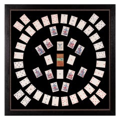
- 1862 Civil War Playing Cards with Stars, Flag, Sheilds and EaglesLocated in York County, PA1862 Civil War playing cards with stars, flags, shields, & eagles, and face cards illustrating civil war officers and lady, Columbia, ca 1862, Benjamin Hitchcock, New York 1862 Civil War playing cards with suits represented by stars, flags, shields, & eagles, in lieu of the traditional French suits of hearts, diamonds, clubs, and spades. The face cards feature Union Army officers and Lady Columbia [a.k.a. Lady Liberty, Goddess of Liberty]. Entitled “Union Playing Cards,” two versions of this deck were produced in New York by Benjamin W. Hitchcock’s “American Card Company.” This is the earlier of the two. The other was released in 1863. There are 52 cards in total with the ace of spades doubling as the title card, as was often the case during the 19th century. The telescoping box...Category
Antique 1860s American Political and Patriotic Memorabilia
MaterialsPaper
 Price Upon Request
 - Historical American Civil War Era Wire Frame Magnifying Eye Glass SpectaclesLocated in Philadelphia, PAA delicate pair of handmade magnifying wire rim eye glasses from the American Civil War era, circa 1860. A great looking historical conversation p...Category
Antique Mid-19th Century American American Classical Historical Memorabilia
MaterialsMetal
- Civil War Socket BayonetsLocated in Norton, MAThree Socket Bayonets. One is a P-53 Civil War era marked "DEAKIN" and has a crown over 53, one is a "US" stamped dull tip, and the last is unmarked or stamped.Category
Antique 19th Century American Arms, Armor and Weapons
MaterialsMetal
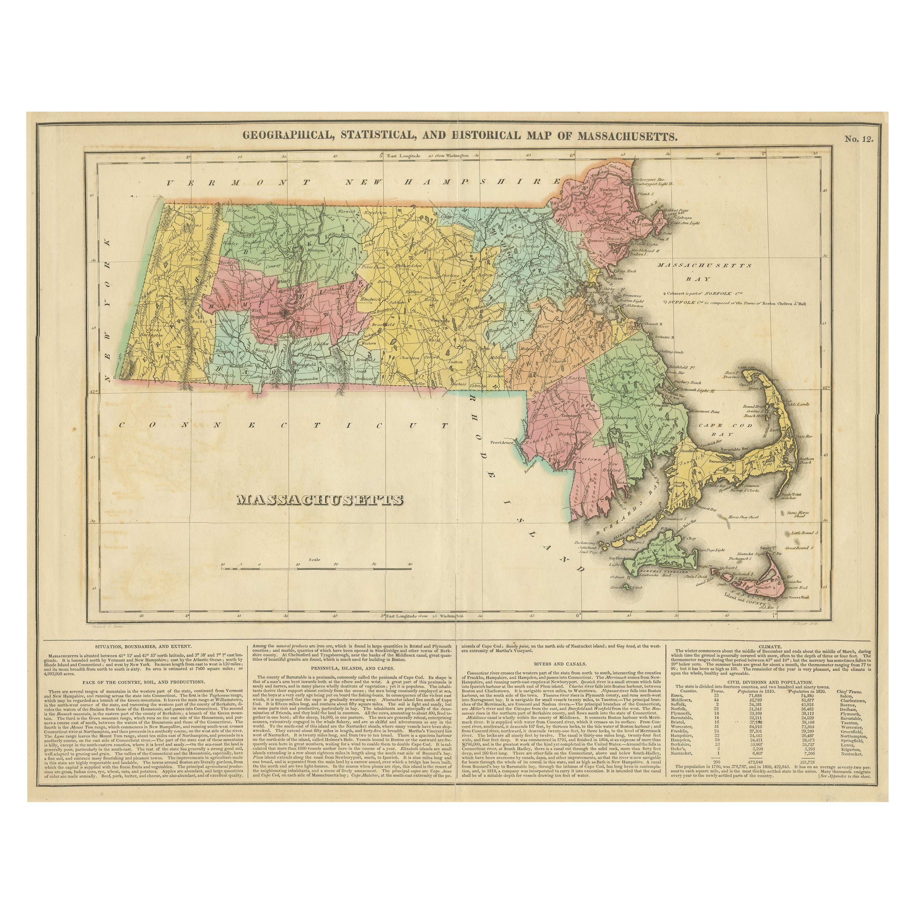
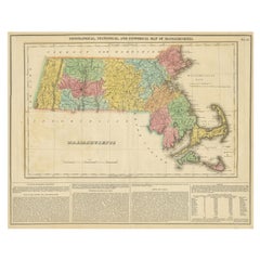
- Antique Geographical, Historical and Statistical Map of Massachusetts, 1822Located in Langweer, NLThis attractive map of Massachusetts presents a finely detailed overview of the state in the first quarter of the 19th century. Transportation ...Category
Antique 1820s Maps
MaterialsPaper
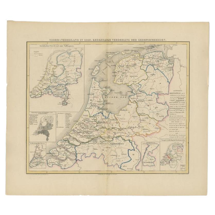
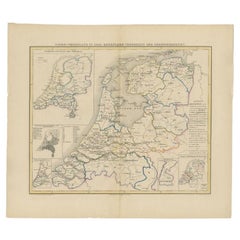
- Antique Map of the Netherlands in 1860 by Mees, 1862Located in Langweer, NLAntique map titled 'Noord-Nederland in 1860. Kerkelijke verdeeling der Gereformeerden'. Map of the Netherlands in 1860. This map originates from 'Historische Atlas van Noord-Nederlan...Category
Antique 19th Century Maps
MaterialsPaper
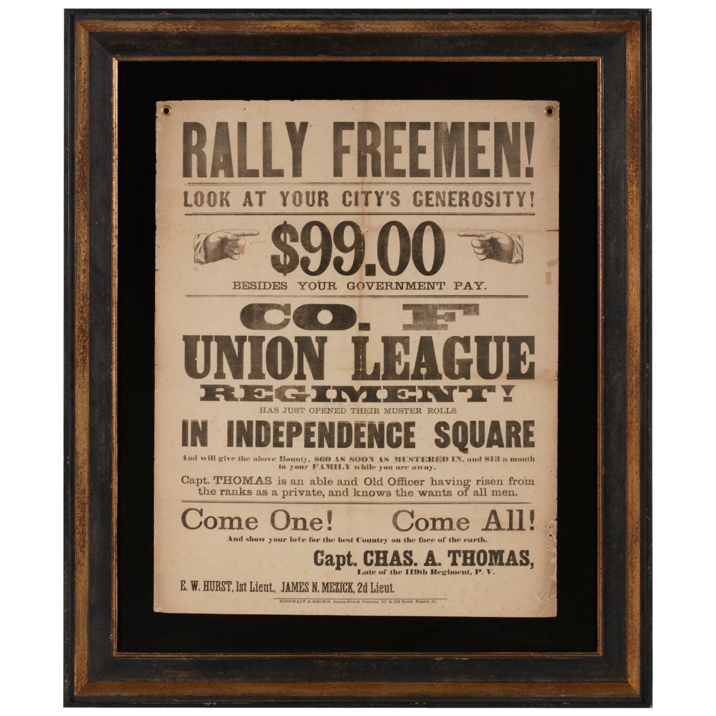
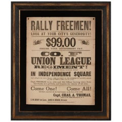
- "Rally Freemen!..." Civil War Recruitment BroadsideLocated in York County, PA"RALLY FREEMEN! …COME ONE! COME ALL! AND SHOW YOUR LOVE FOR THE BEST COUNTRY ON THE FACE OF THE EARTH." A CIVIL WAR RECRUITMENT BROADSIDE FOR THE...Category
Antique 1860s American Political and Patriotic Memorabilia
MaterialsPaper


Recently Viewed
View AllMore Ways To Browse
Railroad Collectibles
Battle Maps
Antique Railroad Collectables
Antique Railroad Collectibles
Antique Railroad Collectibles Collectibles
Southern United States Antiques
Railroad Table
Civil War Map
Virginia Map
Virginia Maps
Pocket Map
Antique Battle Maps
Map Of Virginia
Antique Civil War Maps
Antique Railroad Maps
Map Railroad
Antique Virginia Maps
Virginia Antique Map