Items Similar to 1882 Map of the North Atlantic Ocean Showing Cable Tracks and Trade Winds

Want more images or videos?
Request additional images or videos from the seller
1 of 7
1882 Map of the North Atlantic Ocean Showing Cable Tracks and Trade Winds
$298.99
£220.57
€250
CA$413.91
A$448.80
CHF 238.17
MX$5,527.50
NOK 2,951.98
SEK 2,785.99
DKK 1,903.38
About the Item
This 1882 map of the North Atlantic Ocean, published by Blackie and Son as part of the 'Comprehensive Atlas and Geography of the World,' provides an intricate depiction of one of the most historically significant maritime regions. The map highlights when underwater cables connected the Americas and Europe. It includes key geographic features, such as the British Isles, the eastern United States, the Caribbean, and West Africa, with detailed coastlines and prominent cities like London, New York, and Havana marked.
Bathymetric details, including ocean depths and the location of banks such as the Grand Banks near Newfoundland, are carefully depicted, reflecting the region’s importance for fishing and maritime activities. Trade winds and currents providing insight into the challenges and opportunities for 19th-century navigation. The map also includes subtle pastel coloring to delineate political boundaries and territories.
Condition report: The map is in good condition with light age-related toning and minor spotting. The paper is intact, the engraving is clear, and the colors remain vibrant. There are no visible tears or repairs.
Framing tips: Opt for a classic wooden frame with a dark oak or mahogany finish to complement the historical nature of the map. Use a double mat with a cream or off-white inner mat and a soft blue or light gray outer mat to enhance the oceanic theme. UV-protective glass is recommended to prevent fading and preserve the map’s condition over time.
- Dimensions:Height: 10.63 in (27 cm)Width: 14.97 in (38 cm)Depth: 0 in (0.02 mm)
- Materials and Techniques:
- Period:
- Date of Manufacture:1882
- Condition:Condition report: The map is in good condition with minimal edge wear. Slight toning and occasional spotting are present, consistent with its age. The engraving remains sharp, and the colors are well-preserved. Fold line in middle, as issued.
- Seller Location:Langweer, NL
- Reference Number:Seller: BG-13601-2-651stDibs: LU3054343552992
About the Seller
5.0
Recognized Seller
These prestigious sellers are industry leaders and represent the highest echelon for item quality and design.
Platinum Seller
Premium sellers with a 4.7+ rating and 24-hour response times
Established in 2009
1stDibs seller since 2017
2,620 sales on 1stDibs
Typical response time: <1 hour
- ShippingRetrieving quote...Shipping from: Langweer, Netherlands
- Return Policy
Authenticity Guarantee
In the unlikely event there’s an issue with an item’s authenticity, contact us within 1 year for a full refund. DetailsMoney-Back Guarantee
If your item is not as described, is damaged in transit, or does not arrive, contact us within 7 days for a full refund. Details24-Hour Cancellation
You have a 24-hour grace period in which to reconsider your purchase, with no questions asked.Vetted Professional Sellers
Our world-class sellers must adhere to strict standards for service and quality, maintaining the integrity of our listings.Price-Match Guarantee
If you find that a seller listed the same item for a lower price elsewhere, we’ll match it.Trusted Global Delivery
Our best-in-class carrier network provides specialized shipping options worldwide, including custom delivery.More From This Seller
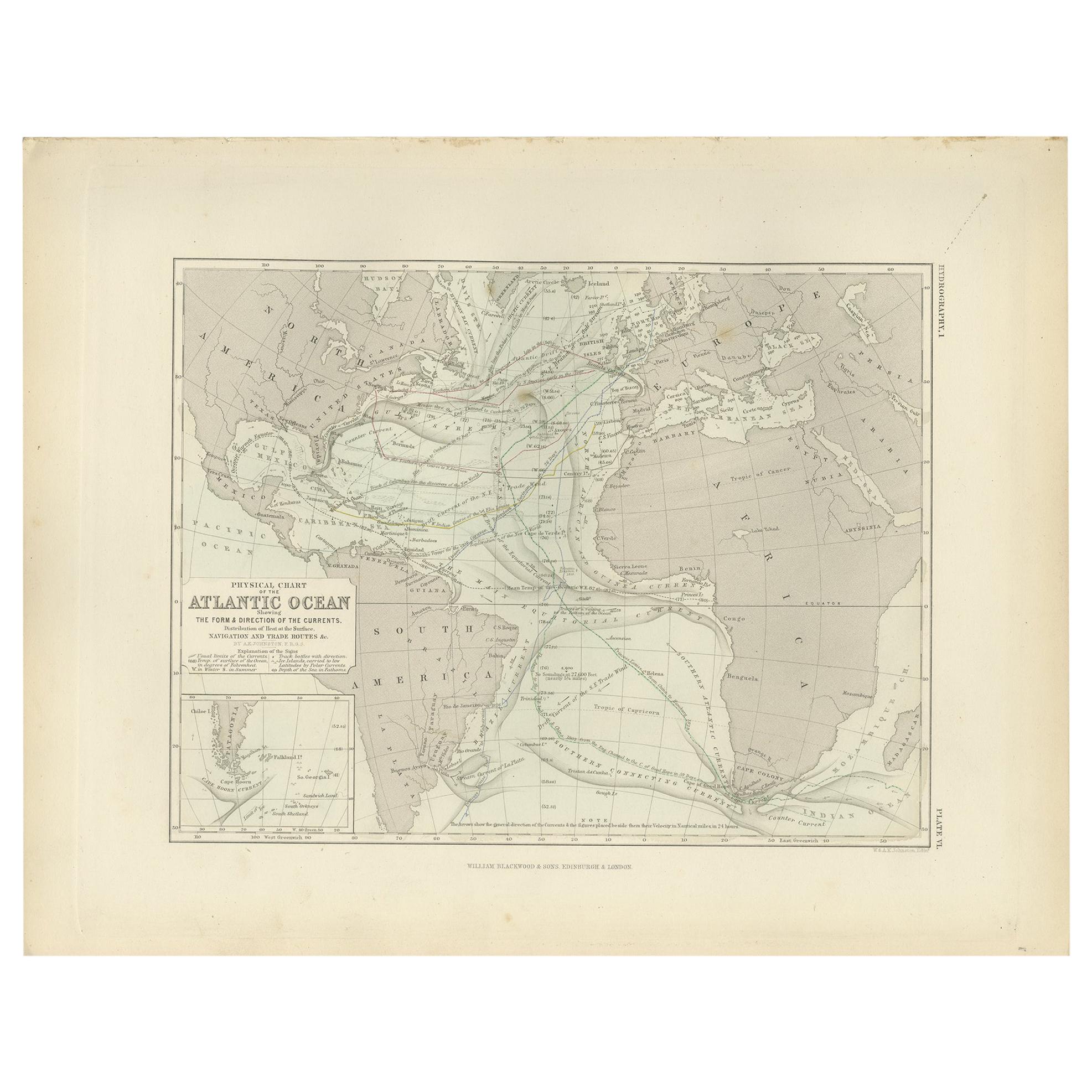
View AllAntique Physical Chart of the Atlantic Ocean by Johnston '1850'
Located in Langweer, NL
Antique map titled 'Physical Chart of the Atlantic Ocean showing the form and direction of the currents'. Original antique chart of the Atlantic Ocean. This map originates from 'The ...
Category
Antique Mid-19th Century Maps
Materials
Paper

$191 Sale Price
20% Off
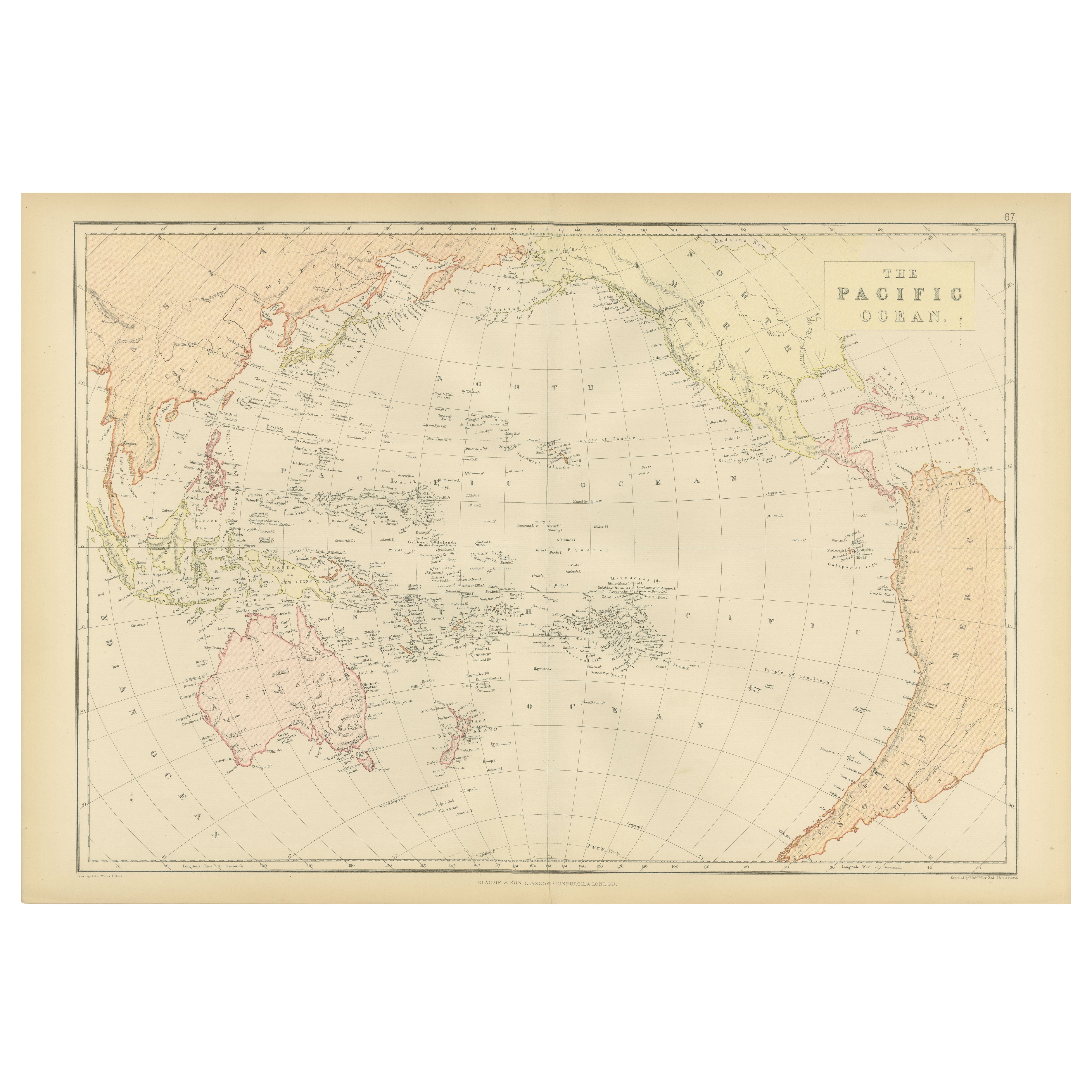
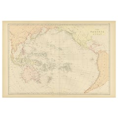
1882 Map of the Pacific Ocean Highlighting Islands and Surrounding Regions
Located in Langweer, NL
This 1882 map of the Pacific Ocean, published by Blackie and Son as part of the 'Comprehensive Atlas and Geography of the World,' presents a detailed and fascinating overview of the ...
Category
Antique 1880s Maps
Materials
Paper
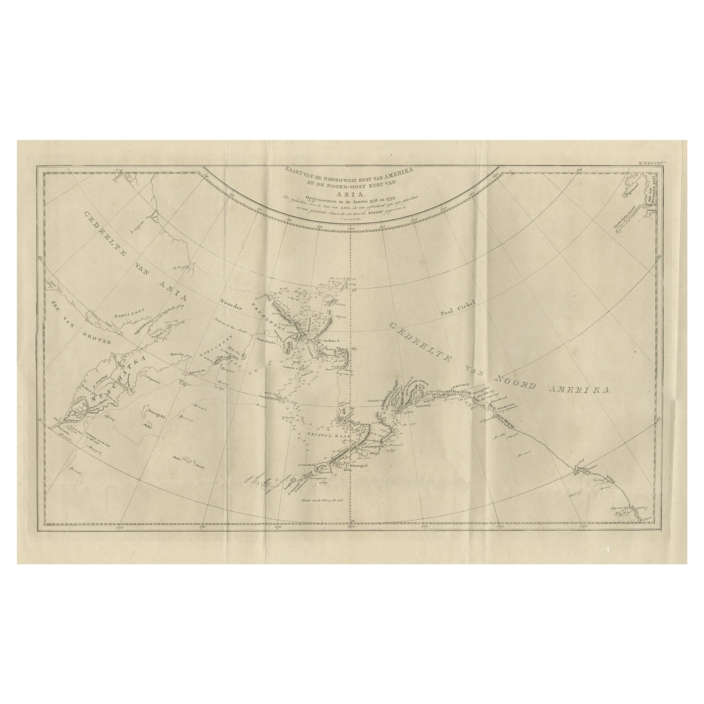
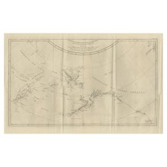
Old Map Showing the Tracks of Cook Between North America and Asia's Coast, 1803
Located in Langweer, NL
Description: Antique map titled 'Kaart van de Noord-West kust van Amerika en de Noord-Oost kust van Asia'.
Antique chart depicting America's northwest coast and Asia's northeast ...
Category
Antique Early 1800s Maps
Materials
Paper
$908 Sale Price
20% Off
Antique Map Showing the Ocean Currents and Temperature of Air, '1872'
Located in Langweer, NL
Two maps on one sheet titled 'Johnson's Oceans Currents (..)' and 'Johnson's World showing the Distribution of the Temperature of the Air'. Original world map...
Category
Antique Late 19th Century Maps
Materials
Paper

$334 Sale Price
20% Off
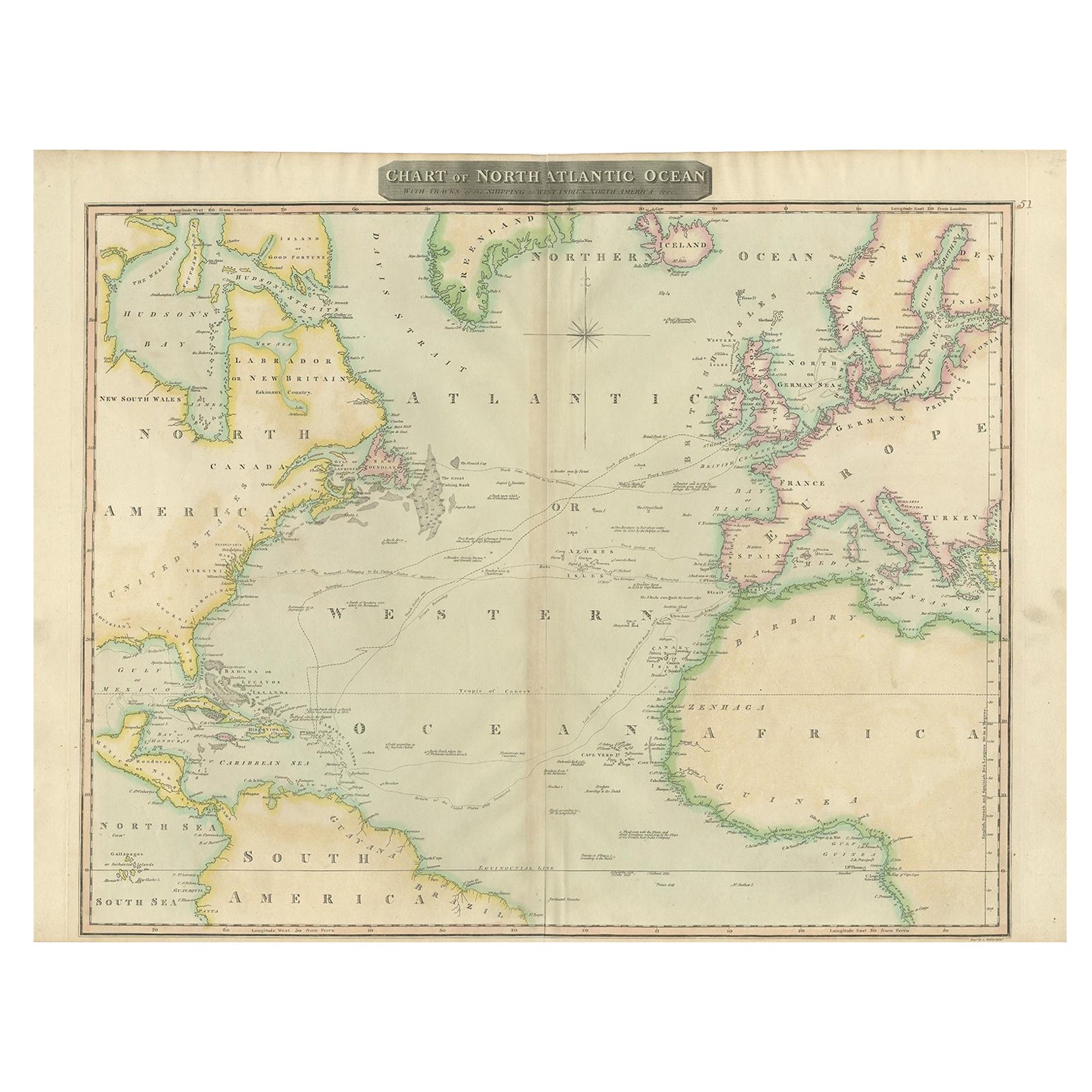
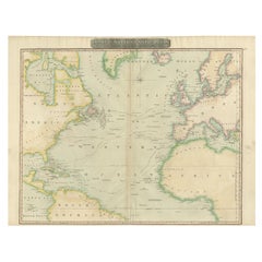
Interesting Map of the Atlantic Showing Nelson's and Trade Routes, 1817
By John Thomson
Located in Langweer, NL
Antique map titled 'Chart of the North Atlantic Ocean with Tracks of the Shipping to West Indies, North America, &cc'. Large map of the Atlantic, showing the tracks of the ships trad...
Category
Antique 19th Century Maps
Materials
Paper
$526 Sale Price
20% Off
Free Shipping
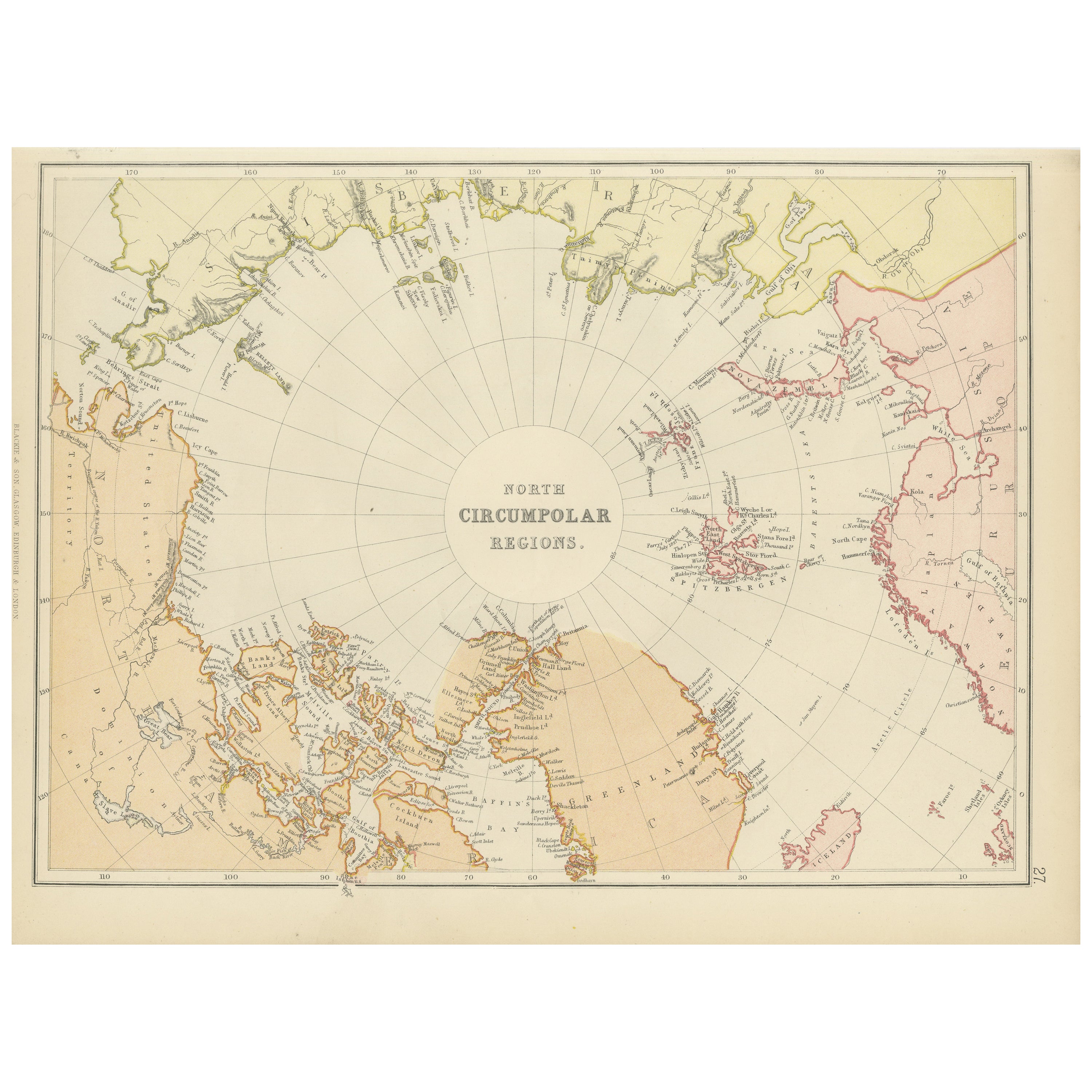
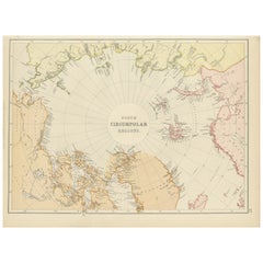
Arctic Exploration: An Original Map of the North Circumpolar Regions, 1882
Located in Langweer, NL
This map, extracted from the 1882 atlas by Blackie & Son, presents the North Circumpolar Regions in a projection centered on the North Pole, offering a unique view of the Arctic territories. The map's radial lines emanate from the pole, focusing on the northernmost parts of continents and the intricate archipelagos that are scattered across the Arctic Ocean.
The territories of Canada, Greenland, Northern Europe, Russia, and the northern extremities of Asia are portrayed with careful detail, highlighting the geography known to Victorian explorers. Notably, the map's color palette is subdued, with the cold regions depicted in pale hues, while coastlines and political boundaries are traced in warmer tones, providing a stark contrast that emphasizes the frigid environment.
The map likely served purposes both educational and navigational, capturing the extent of polar exploration at the time. Names of seas, straits, and islands honor explorers and patrons of the age of Arctic exploration, and the map also hints at the incomplete knowledge of the era, with some areas less detailed than others, reflecting the limits of exploration and cartographic knowledge of the Arctic region at that time.
Moreover, the map includes longitudinal and latitudinal markers, which would have been crucial for navigation and expedition planning. The inclusion of such detail illustrates the growing interest in polar exploration during the late 19th century...
Category
Antique 1880s Maps
Materials
Paper
$267 Sale Price
20% Off
You May Also Like
Original Imray & Son Chart of North Atlantic, 1876
Located in Norwell, MA
Nautical chart of the North Atlantic showing the Eastern United States coast, Caribbean Islands, South America (Venezuela and ), British Possessions (Canada - Gulf of Lawrence, Newfo...
Category
Antique 1870s Nautical Objects
Materials
Paper

Large Original Antique Map of The Pacific Ocean, Fullarton, C.1870
Located in St Annes, Lancashire
Great map of The Pacific Ocean
From the celebrated Royal Illustrated Atlas
Lithograph by Swanston. Original color.
Published by Fullarton,...
Category
Antique 1870s Scottish Maps
Materials
Paper

Large Original Vintage Map of The North Pole, circa 1920
Located in St Annes, Lancashire
Great maps of The North Pole.
Unframed.
Original color.
By John Bartholomew and Co. Edinburgh Geographical Institute.
Published, circa 1920.
Free shipp...
Category
Vintage 1920s British Maps
Materials
Paper
Northwest Coast and Isle of Man Map
Located in Cheshire, GB
Greenville Collins Northwest Coast and Isle of Man. hand coloured chart, encased in an ebonised frame.
Dimensions
Height 26.5 Inches
Width 30 Inches
Depth 1 Inches
Category
Early 20th Century British Maps
Materials
Paper

$525 Sale Price
20% Off
Antique Maritime Chart of East Coast Virginia to Nova Scotia
Located in Norwell, MA
1920 nautical chart of the East Coast of the United States from Virginia to Maine, New Brunswick, and Nova Scotia. The chart shows Cape Cod, Long Island, the Connecticut coast, Jersey Shore, Maine, New Hampshire, etc. Very detailed, showing ports, lighthouses, shoals, depths, etc. The chart is by famous cartographer George W. Eldridge, compiled from surveys of the United States government, British Admiralty, George Eldridge, and others. First authorized by George Eldridge, published in 1916 by Wilfred O. White with a merchant's stamp of Charles Hutchinson...
Category
Vintage 1920s North American Maps
Materials
Paper

Large U.S. Coast and Geodetic Survey Chart A of the Atlantic Coast, 1877
Located in Nantucket, MA
Large U.S. Coast and Geodetic Survey Chart A of the Atlantic Coast, 1877, re-issued in February 1881, a printed paper laid down on linen navigational chart of the U.S. Atlantic coast...
Category
Antique 1880s American Other Maps
Materials
Linen

More Ways To Browse
North Wind
North Wind Furniture
North Wind Antique Furniture
Couch Console
Sterling Silver Flatware Service For 12
Antique Dining Tables With Leaves
Decorative Wall Panels
Frank Lloyd Wright For Cassina
Natural Curved
Spanish Wool Rug
Leather Pouf And Ottomans
Low Side Tables
Set Of Four Italian Dining Chairs
Silk Runner Carpet
18th Century Blue And White Porcelain
3x5 Rugs
Italian Lacquer Dining Room Sets
Round Brass Table