1 of 8
18th Century French Map and City View of Joppe/Jaffa 'Tel Aviv' by Sanson
$1,075List Price
About the Item
- Creator:Nicolas Sanson (Artist)
- Dimensions:Height: 18.88 in (47.96 cm)Width: 23 in (58.42 cm)Depth: 1.13 in (2.88 cm)
- Materials and Techniques:Paper,Engraved
- Place of Origin:
- Period:
- Date of Manufacture:1709
- Condition:Wear consistent with age and use.
- Seller Location:Alamo, CA
- Reference Number:Seller: # 39261stDibs: LU5206220653472
Authenticity Guarantee
In the unlikely event there’s an issue with an item’s authenticity, contact us within 1 year for a full refund. DetailsMoney-Back Guarantee
If your item is not as described, is damaged in transit, or does not arrive, contact us within 7 days for a full refund. Details24-Hour Cancellation
You have a 24-hour grace period in which to reconsider your purchase, with no questions asked.Vetted Professional Sellers
Our world-class sellers must adhere to strict standards for service and quality, maintaining the integrity of our listings.Price-Match Guarantee
If you find that a seller listed the same item for a lower price elsewhere, we’ll match it.Trusted Global Delivery
Our best-in-class carrier network provides specialized shipping options worldwide, including custom delivery.You May Also Like
17th Century Map of Denmark by French Cartographer Sanson, Dated 1658
By Nicolas Sanson
Located in Copenhagen, K
17th century map of Denmark by French cartographer Sanson.
Nicolas Sanson (20 December 1600-7 July 1667) was a French cartographer, termed by some the creator of French geography an...
Category
Antique 17th Century French Maps
Materials
Paper

$1,750
H 18.51 in W 23.23 in D 0.4 in
Antique Map of Madagascar by N. Sanson, circa 1680
By Nicolas Sanson
Located in Langweer, NL
Antique map titled 'Isle de Madagascar ou de St. Laurens. Tiree de Sanutu &c'. Antique map of Madagascar, first published by Sanson in 1657. Sanson n...
Category
Antique Late 17th Century Maps
Materials
Paper
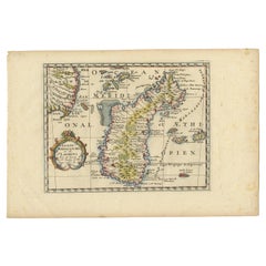
$239 Sale Price
20% Off
H 9.65 in W 14.57 in D 0.02 in
Antique Map of Asia by Sanson, circa 1705
By Nicolas Sanson
Located in Langweer, NL
Dutch edition of Sanson's map of Asia. Shows a large, dramatic version of Terre de Jesso, drawn from the discoveries of the Maarten de Vries expedition of 1643.
Category
Antique Early 18th Century Dutch Maps
Materials
Paper

Original Hand-coloured Antique Map of Pomerania by Sanson '1684'
By Nicolas Sanson
Located in Langweer, NL
Antique map titled 'Le Duche de Pomeranie divise en ses Principales Parties (..)'. Large map of Pomerania. Pomerania is a historical region on the southern shore of the Baltic Sea in...
Category
Antique Late 17th Century Maps
Materials
Paper
$911 Sale Price
20% Off
H 25.01 in W 36.62 in D 0.02 in
Antique Map of Russia by N. Sanson, 1705
Located in Langweer, NL
A strongly engraved map of European Russia showing its political divisions, major topographical features, cities and towns. Extends to the Sea of Azov and the tip of the Caspian Sea ...
Category
Antique Early 18th Century Maps
Materials
Paper

Antique Map of Japan and Korea by Sanson, 'c.1690'
Located in Langweer, NL
Antique map titled 'Les Iles du Iapon (..)'. Original antique map, with beautiful (later) hand coloring, of Japan and the Island of Corey (Korea). Uncommon edition, with '234' at top...
Category
Antique Late 17th Century Maps
Materials
Paper

$959 Sale Price
20% Off
H 8.47 in W 10.83 in D 0.02 in
Antique Map of India and Southeast Asia by Sanson '1654'
Located in Langweer, NL
Antique map titled 'Partie Meridionale de l'Inde'. Early map of India and Southeast Asia. The map shows most of modern India, Bangladesh and Burma, the whole of Sri Lanka, Thailand, ...
Category
Antique Mid-17th Century Maps
Materials
Paper
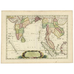
$1,150 Sale Price
20% Off
H 17.72 in W 23.82 in D 0.02 in
Antique Map of the Congo, Gabon and Angola by N. Sanson, circa 1700
Located in Langweer, NL
Attractive map of Gabon, the Congo and Angola from Cape Lopez and Sao Tomé to approximately the border with present-day Namibia. The map is fully engraved with mountains, rivers, for...
Category
Antique Early 18th Century Maps
Materials
Paper
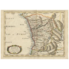
$268 Sale Price
20% Off
H 8.43 in W 11.62 in D 0.02 in
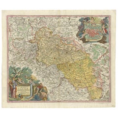
Antique Map of Silesia, Southwest Poland and a City View of Wroclaw, c 1720
By Johann Baptist Homann
Located in Langweer, NL
Antique map titled 'Superioris et Inferioris ducatus Silesiae (..)'.
Detailed map of Silesia by Johann Baptist Homann. Shows the Southwestern part of Poland between Frankfurt Oder ...
Category
Antique Early 18th Century Maps
Materials
Paper
$1,138
Free Shipping
H 21.66 in W 24.81 in D 0.02 in
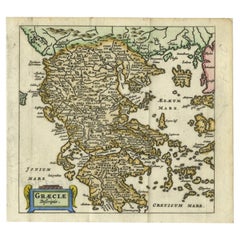
Charming 18th Century Miniature Map of Greece, 1685
Located in Langweer, NL
Antique map titled 'Graeciae Descriptio.' Charming miniature map of Greece from the pocket atlas 'Introductionis in Universam Geographiam tam Veterem qu...
Category
Antique 17th Century Maps
Materials
Paper
Recently Viewed
View AllMore Ways To Browse
Map Of Holy Land
Antique Maps Australia
Used Nautical Charts
Antique Collectables Australia
Joan Blaeu
Map Greece
Antique Maps Of New York City
Map Railroad
Antique Railroad Maps
Pirate Antique
Antique Maps Of Greece
Brazilian Antiques
Turkey Map
Map Of Japan
Antique Nautical Charts
Denmark Map
Antique Macedonia
Hemispheres Map